Solar Grand Solar Minimum part deux

TheSearcher

Are you sure about that?
Soe of my favorites: The resilient gardener by Carol Deppe. IMO about the best out there for growing food to stay fed. She focuses on 5 crops: Corn, beans, eggs, potatoes and squash. THe Joy of Gardening by Dick Raymond. Book from the 80s on basic gardening. He sells the Troybilt tiller pretty hard but it is a good book. Eliot Colemans Four Season Harvest or Four Season Farm Gardeners Cookbook. Both get into gardening year-round in a cold climate with greens growing in greenhouse all year long. A great all around Book is Carla Emerys Encyclopedia of Country Living. Gives you a taste of everything. Also hit up your state extension service as they will have a lot of free info on growing different things in your area. Most of all try stuff. Don't hesitate to plant something because you are afraid of screwing up. Plant it screw up and learn. I would say pick a half dozen things and focus on those. Lear what you can and try it!!

Thanks to you too! Yep, I figured I'd just try whatever sounded good, and see what happens. And the extension service seems like a great idea.
 

TxGal

Day by day

Historic cold headed for Upper Midwest and Ontario

May 5, 2020 by Robert

Polar vortex to bring record cold to Ontario,” reads the headline. But when you look at the maps, you find that Minnesota, Wisconsin and Michigan are also slated for historic cold … And maybe snow.

5 May 2020 – Environment Canada warns that much of Ontario can expect record cold temperatures for at least the next week.

Gerald Cheng, a warning preparedness meteorologist with Environment Canada, said residents in some areas of eastern and southern Ontario can expect to see nighttime temperatures dip below zero on Friday and Saturday, with cooler temperatures sticking around until the weekend.

Cheng said the seasonal daytime temperature for Ontario during this time of year is usually around 17 C with nighttime lows not going below 7 C.

“So we’re talking about nine to 10 degrees off, so you can expect record cold temperatures for the time of year,” Cheng said.

Polar vortex to bring record cold temperatures to Ontario: Environment Canada

May Snow Threat

The historic cold also brings the potential for “significant” snow across the Great Lakes Basin into the weekend, particularly over higher terrain.

Snowfall isn’t exceptionally unusual in northern Ontario in May, but it is quite extraordinary for parts of southern Ontario (especially “significant” amounts).

Toronto typically accumulates a few centimetres of May snowfall every couple of decades, but it was notably more common in the 1960s and 1970s.

Expect continuous threats of snow flurries, squals and rounds of graupel.

The Weather Network - Polar vortex could bring historically cold temperatures to Ontario

Thanks to Argiris Diamantis (and a reader who prefers not to be named) for these links
 

Martinhouse

Deceased
Searcher, dewberries don't really make canes. They straggle all over the ground and don't have big sturdy stalks. I don't know if they send up new shoots or if the original plants just produce each year. Maybe someone else can tell you.

You'll be able to dig your blueberry up and take it with you if it doesn't grow too much right away, but the longer you wait, the harder it will be on the bush. My four were languishing until I moved them to containers made from cutting 55 gallon food grade plastic barrels in half. Now they are doing quite well and actually have a few berries on them this spring.

You need to have a second blueberry bush planted so there is a pollinator. It can be a different variety but should bloom at the same time as your present one. As in Early, Mid-season, or Late. I've seen bushes at two different places that were a single planting and they appeared to bear well, but I always suspected there might have been a pollinator somewhere in their neighborhoods. Also, I have no idea if there is such a thing as a self-pollinating blueberry.
 

TxGal

Day by day

1588771061794.png

The Month of May Brings Record (Sometimes Historic) Cold to BOTH Hemispheres

May 6, 2020 Cap Allon


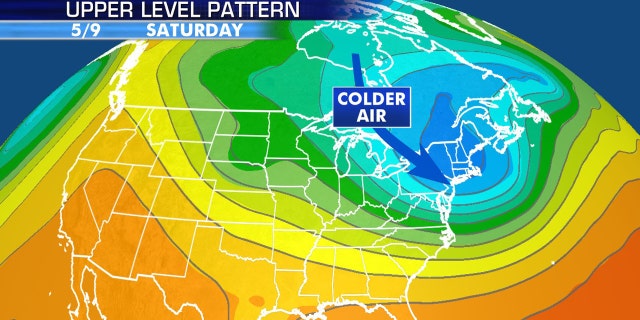
A meridional (wavy) jet stream flow –associated with low solar activity– is in full swing, dragging brutal polar air anomalously-far south/north.

Record (sometimes historic) COLD is currently buffeting vast regions of the globe, from North America to Australia, Europe to Southern Africa. You really do have to hand it to the global warming cabal — even in the face of such extreme odds -and logic- they’re doggedly pursuing their absurd “world on fire” rhetoric:


View: https://twitter.com/washingtonpost/status/1257745133216333825?ref_src=twsrc%5Etfw%7Ctwcamp%5Etweetembed%7Ctwterm%5E1257745133216333825&ref_url=https%3A%2F%2Felectroverse.net%2Fthe-month-of-may-brings-record-sometimes-historic-cold-to-both-hemispheres%2F


Though it’s easy to paint a picture when you’re in control of the brush strokes. Using debunked climate models and fraudulent temperature datasets will see you arrive at whatever conclusion you desire — it’s really that simple.

Ignoring the Urban Heat Island (UHI) effect, as the IPCC do, and then extrapolating those cosmopolitan temperature readings out to the rest of the planet will of course skew the picture. When natural vegetation is replaced with buildings, pavement, and spurious heat sources like air conditioning units, cars, and ice cream trucks are added, the microclimate around thermometer sites changes.

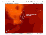
For example, as pointed out by Dr. Roy Spencer, this time last year Miami International Airport set a new high temperature record of 98F for the month of May. The thermometer in question is at the west end of the south runway at the airport, at the center of the Miami-Ft. Lauderdale metroplex:

1588771240708.png
GFS surface temperature analysis for around midnight, 28 May 2019.

Furthermore, U.S. government agency NOAA are adjusting the cooler, rural data to match the urban data, instead of the other way around.

And and on top of that obfuscation and fraudulent extrapolation, where no thermometer station coverage exists –so the majority of the planet then– our friends NOAA simply “guess” or “fill in the gaps”.

With this guesswork the agency, in partnership with a few small fractions of other organizations (such as NASA’s Goddard Institute for Space Studies), have managed to craft a wholly unnaturally linear temperature trend that is supposedly on course to deliver Earth an “unprecedented climatic catastrophe” within the next few months/years/decades — nobody can quite agree on the time-frame…

Image result for gavin schmidt nasa giss


And for those still buying the rhetoric, and happy to cite the above Temperature Anomaly graph as proof of the coming heat-induced catastrophe, why the multidecadal pause in rising temps between 1940-1980…? CO2 emission were increasing substantially during this time…? And if that innocuous question is hurting your head, its because the answer is the Sun — a forcing the IPCC refuses to even factor into its models.

The planet as a whole has been substantially cooling for at least the past 5 years — even NOAA’s own datasets confirm this.

And that cooling trend is continuing into May, 2020 — just as the Northern Hemisphere hits a key growing stage. Expect vast crop losses moving forward. Mitigate these by growing your own. Now is the time to get your hands dirty.

North America (May 10)

gfs_T2ma_namer_19.png


South America (May 7)

gfs_T2ma_samer_7.png

Europe (May 13)

gfs_T2ma_eu_30.png

Southern Africa (May 11)

gfs_T2ma_safr_22.png


Australia (May 21)

gfs_T2ma_aus_63.png


The truth is out there, for those willing to search it out.

The COLD TIMES are returning in line with historically low solar activity, cloud-nucleating Cosmic Rays, and a meridional jet stream flow.

Even NASA agrees, in part at least, with their forecast for this upcoming solar cycle (25) revealing it will be “the weakest of the past 200 years,” with the agency correlating previous solar shutdowns to prolonged periods of global cooling here.


1588771459260.png

Don’t fall for bogus warm-mongering, UHI-ignoring political agendas — our future is one of ever-descending COLD.

Prepare accordinglearn the cycles, relocate if need be, and grow your own.
 

TxGal

Day by day
New Adapt 2030 podcast:

View: https://www.youtube.com/watch?v=ba_5X6fduJg


History Shows Where We Go From Here (972)
7,311 views
•May 5, 2020

Run time is 12:31

Through history we have seen blockades that always lead to food insecurity and here we are again , a rhyme in history that we have seen time immemorial. Cut off of the global food supply beginning with protein first. You have seen headlines shouting food shortages and meat packing plants closing. Its true, its here and you may want to get a plan C flushed out.
 

TxGal

Day by day
The Oppenheimer Ranch Project has a new podcast out:

View: https://www.youtube.com/watch?v=CLEWVJpRTDM


Arctic Blast Set To Punish Northeast with Cold & May Snow - Power Outages in Tennessee - Comet Swan
4,547 views
•Premiered 16 hours ago

Run time is 9:26

May snow, spring polar vortex to shock parts of US https://bit.ly/3c70HS9
Arctic blast set to punish Northeast with cold, May snow https://bit.ly/2ytP5d6
Tennessee storms leave over 100K without power in Nashville area, off-duty firefighter killed https://fxn.ws/2L4iRIo
More than 80,000 remain without power after storm causes one of Nashville's largest outages on record https://bit.ly/2yz5YTI
Power Outage US https://poweroutage.us/
Severe storms glow green over the central US, turn deadly in Missouri https://bit.ly/2ykHyNX
A landslide in New York state leaves homes dangling inches away from a giant crater https://cnn.it/2zeLq2O
Lehigh Valley weather: How can it possibly snow this week? Here’s how https://bit.ly/3dqkjAZ
Heat Continues to Build Across the West https://www.weather.gov/
GFS Model Northeast Snowfall https://bit.ly/2SCn61G
Worldwide Volcano News and Updates: http://bit.ly/2v9JJhO
Global Cryosphere Watch https://globalcryospherewatch.org/sat...
New Paper Has a Wild Explanation For The Most Explosive 'Meteor Impact' on Record https://bit.ly/2SFbefq
Comet Swan is now visible and could be the best in years https://bit.ly/2SEtDJA
Fossilized remains of 400-million-year-old newly discovered plant could change 'evolutionary history' https://fxn.ws/3b4A9PR
 

TxGal

Day by day

"Winter-Like Chill" Targets East For Mother's Day Weekend
by Tyler Durden Wed, 05/06/2020 - 05:30

Warming weather trends across the US over the last week forced many people out of their homes and into parks and beaches, to only ignore the government enforced stay-at-home public health orders. Now there's a blast of frigid air that is expected to bring record-low temperatures in some areas for Mother's Day weekend.

"The weekend cold will be the second of two shots of Arctic air spilling into the eastern half of the Lower 48 this week as a chillier-than-normal pattern that began in mid-April shows little sign of relenting. This abnormally cold weather marks a major departure from January through March when temperatures were much warmer than normal," The Washington Post wrote.

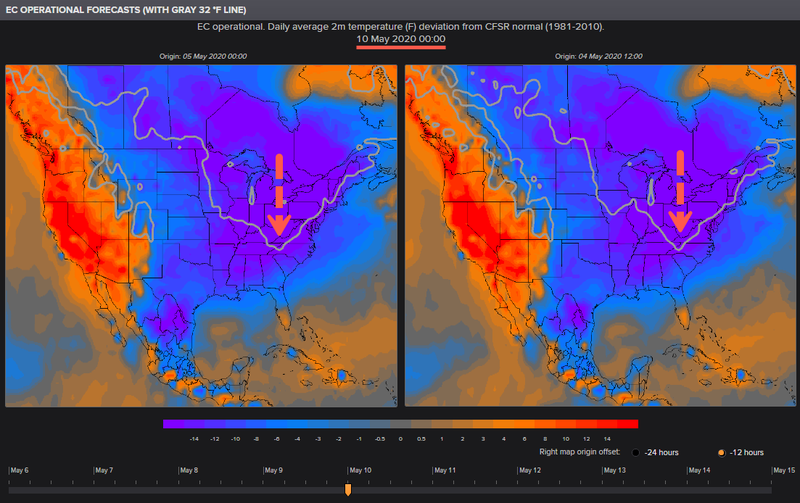
EC operational forecasts show the frost line will dive this weekend into the Southern US and could impact crops, likely delaying some spring plantings.


"Temperatures may approach record cold levels for some areas with a late frost/freeze where the growing season has typically started," wrote the National Weather Service (NWS).

"An amplified pattern will bring in late winter-like chill to much of the East later this week into the weekend as the West will see well above normal temperatures. Guidance remains in good agreement on one upper low swinging through the Great Lakes Friday and out of New England late Saturday with perhaps another one out of central Canada early next week close to Lake Superior. Blend of the deterministic guidance sufficed to start the period as low pressure deepens as it leaves the Ohio Valley toward the Maine coast by early Saturday. Weaker shortwave aloft and surface front will trail behind and bring in additional cooler air to the Plains and MS Valley this weekend, with the 18Z GFS/12Z ECMWF paired well with their ensemble means. By next Mon/Tue, pattern will start to break down."

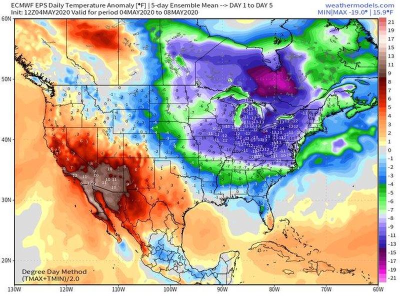
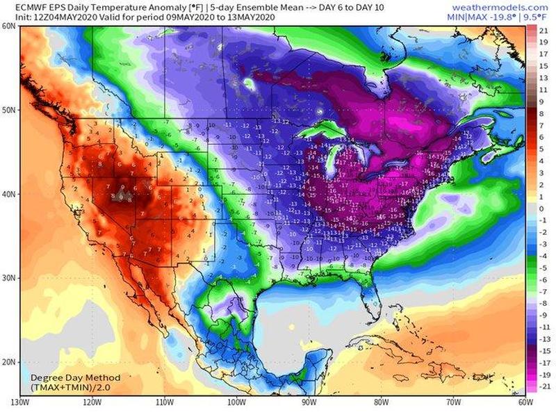
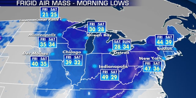
Meteorologist Ryan Maue tweeted, "Next 10-days look to be the coldest first-half of May in a long while. Average daily temperatures 10° to 20°F below normal across much of the Eastern US Actual highs will average in the 40s and 50s with overnight lows in the 20s and 30s."

Temperature Anomaly Day 1 to Day 5


Temperature Anomaly Day 6 to Day 10


Michael Palmer, a meteorologist at the Weather Company, said the blast of cold air could produce record low temperatures for the Pittsburg area on Saturday.

View: https://twitter.com/WeatherWorldPSU/status/1257300118388310021


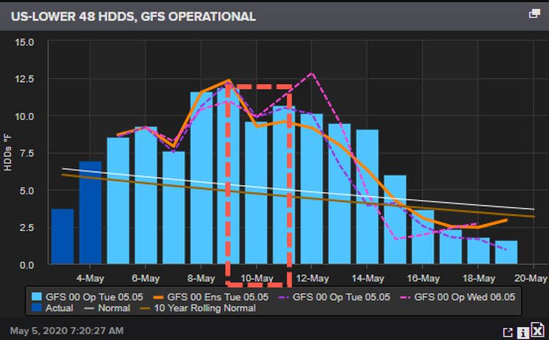
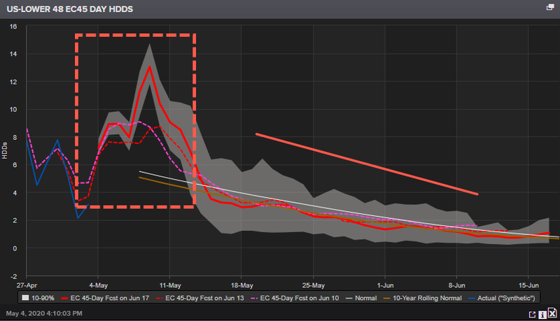
Heating degree day (HDD), the measurement designed to quantify the demand for energy needed to heat a building, is expected to surge for the Lower 48 by Friday and through the weekend. This means that cold weather could force many people in the Midwest, Southeast, and Northeast to turn on their heat this weekend. The good news is that warmer weather is expected to return in the second half of the month.


A 45 day HDD Lower 48 suggests that the blast of cold air this upcoming weekend will be the last of the year.


Summer is ahead...
 

TheSearcher

Are you sure about that?
Searcher, dewberries don't really make canes. They straggle all over the ground and don't have big sturdy stalks. I don't know if they send up new shoots or if the original plants just produce each year. Maybe someone else can tell you.

You'll be able to dig your blueberry up and take it with you if it doesn't grow too much right away, but the longer you wait, the harder it will be on the bush. My four were languishing until I moved them to containers made from cutting 55 gallon food grade plastic barrels in half. Now they are doing quite well and actually have a few berries on them this spring.

You need to have a second blueberry bush planted so there is a pollinator. It can be a different variety but should bloom at the same time as your present one. As in Early, Mid-season, or Late. I've seen bushes at two different places that were a single planting and they appeared to bear well, but I always suspected there might have been a pollinator somewhere in their neighborhoods. Also, I have no idea if there is such a thing as a self-pollinating blueberry.

Well, this is most definitely a blackberry, not a dewberry, so what you told me is most likely correct.

As for the blueberry bush, the nursery was going to sell me a second one for a pollinator, then he checked the one I had and said it was indeed a self-pollinator. So I think I'm good.

Thanks again!
 

TheSearcher

Are you sure about that?

"Winter-Like Chill" Targets East For Mother's Day Weekend
by Tyler Durden Wed, 05/06/2020 - 05:30

Warming weather trends across the US over the last week forced many people out of their homes and into parks and beaches, to only ignore the government enforced stay-at-home public health orders. Now there's a blast of frigid air that is expected to bring record-low temperatures in some areas for Mother's Day weekend.

"The weekend cold will be the second of two shots of Arctic air spilling into the eastern half of the Lower 48 this week as a chillier-than-normal pattern that began in mid-April shows little sign of relenting. This abnormally cold weather marks a major departure from January through March when temperatures were much warmer than normal," The Washington Post wrote.

EC operational forecasts show the frost line will dive this weekend into the Southern US and could impact crops, likely delaying some spring plantings.


"Temperatures may approach record cold levels for some areas with a late frost/freeze where the growing season has typically started," wrote the National Weather Service (NWS).


Meteorologist Ryan Maue tweeted, "Next 10-days look to be the coldest first-half of May in a long while. Average daily temperatures 10° to 20°F below normal across much of the Eastern US Actual highs will average in the 40s and 50s with overnight lows in the 20s and 30s."

Temperature Anomaly Day 1 to Day 5


Temperature Anomaly Day 6 to Day 10


Michael Palmer, a meteorologist at the Weather Company, said the blast of cold air could produce record low temperatures for the Pittsburg area on Saturday.

View: https://twitter.com/WeatherWorldPSU/status/1257300118388310021


Heating degree day (HDD), the measurement designed to quantify the demand for energy needed to heat a building, is expected to surge for the Lower 48 by Friday and through the weekend. This means that cold weather could force many people in the Midwest, Southeast, and Northeast to turn on their heat this weekend. The good news is that warmer weather is expected to return in the second half of the month.


A 45 day HDD Lower 48 suggests that the blast of cold air this upcoming weekend will be the last of the year.


Summer is ahead...

It looks to me like that anomaly is getting bigger and bigger...
 

Martinhouse

Deceased
I just happened on a new Ice Age Farmer podcast that appears to be just about over with.

Okay, it's over now. "Meat Shortages Just the Start - Forces Creating Food Shortages."

rt 21:64
 

TxGal

Day by day
I just happened on a new Ice Age Farmer podcast that appears to be just about over with.

Okay, it's over now. "Meat Shortages Just the Start - Forces Creating Food Shortages."

rt 21:64

I just did the same thing! Posting it in just a few.
 

TxGal

Day by day
Ice Age Farmer has a new podcast out:

View: https://www.youtube.com/watch?v=Inur-e-SscI


Meat Shortage Just the Start -- Forces Creating Food Shortages
14,047 views
•Premiered 113 minutes ago

Run time is 21:03

Wendy's has stopped serving burgers. Kroger/Costco are limiting meat purchases. How long will this last? Will other food be affected? Christian breaks down the forces at work to make the meat shortages permanent, and details that ALL food is in fact being targeted -- not just meat.
 

TxGal

Day by day

'Polar opposites:' May cold snap to leave eastern US chillier than parts of Alaska

By Alex Sosnowski, AccuWeather senior meteorologist
Updated may 6, 2020 12:56 PM

(forecast video here I can't bring over)

An unusually late taste of winter for this time of year across much of the eastern United States will leave major cities from Atlanta to Detroit to Boston colder than parts of Alaska this weekend. The upcoming cold snap, which will allow snow to accumulate in parts of the interior Northeast, will likely help with social distancing efforts, one week after residents across the East used the surge of warmth as a way to exercise, sunbathe or do basically anything to relieve cabin fever as a result of the ongoing shelter-in-place orders.

As cities such as Pittsburgh, Detroit and Buffalo challenge record lows, Fairbanks, Alaska, will approach 80 degrees Fahrenheit on Mother’s Day, which is about 20 degrees above the normal high for May 10. Farther south in The Last Frontier, it will be cooler in Anchorage over the weekend, but with temperatures in the low 60s, highs will still be about 4-5 degrees above average -- and higher than some places in the Northeast.

A weather pattern more fitting of early March in the Northeast will lead to the likelihood of cold winds, damaging frosts and freezes, as well as unusually large swaths of accumulating snow and lake-effect snow for May.
WidePVSatellite.gif

A storm with rain and snow is seen diving southward over the central Appalachians as a mass of clouds associated with the polar vortex spins near Hudson Bay in Canada on this Wednesday, May 6, 2020, satellite loop. (NOAA / GOES-East)

"A lobe of the polar vortex will spin southward and loop around the Great Lakes and northeastern United States into next week before shifting farther northwest over Canada toward the middle of May," Paul Pastelok, AccuWeather's top long-range forecaster, said.

1588805655723.png

As the jet stream plunges across the eastern U.S., allowing the unusually cold weather to press southward, it is bulging northward in the West. An oppressive heat wave is affecting L.A., Phoenix and Las Vegas as warmth builds across the Pacific Northwest and up toward Alaska.

1588805692231.png

"What a pattern across the United States! Look at that big jet stream across the eastern U.S. Meanwhile, in the West, it’s totally opposite, polar opposite, where we’re looking at record warmth... It will be warmer in Alaska than it will be in Atlanta, Georgia. That’s something," AccuWeather Chief On-Air Meteorologist Bernie Rayno said.

Way too cold for May in the East
Even though strong May sunshine will work to negate some of the chill by day, where thick clouds linger and rain or snow falls, daytime temperatures can hover in the 30s to lower 40s F, which is about 20-30 degrees below normal in the Midwest and Northeast.

1588805744677.png

However, despite the warm May sun shining, some locations can still rival record low maximum temperatures as the air coming in is from the Arctic. Washington, D.C., will challenge a record low maximum temperature of 52 on Saturday -- a mark that has stood since 1877. The 143-year-old record at stake in the nation's capital is a testament to the magnitude of the frigid air coming into the region.

CLICK HERE FOR THE FREE ACCUWEATHER APP

"Other places where low maximum temperature records could be set on Saturday include Hartford, Connecticut, Boston and Mount Pocono, Pennsylvania, to name a few," AccuWeather Meteorologist Jesse Ferrell said. The old low maximum temperature records are 45 in 1972, 45 in 1966 and 41 in 1947, respectively.
 

Attachments

  • 1588805925013.png
    1588805925013.png
    378 bytes · Views: 1

TxGal

Day by day


1588806214376.png

Global Temperatures Suffer Second Largest Two Month Drop in Recorded History

May 6, 2020 Cap Allon


The Temperature of the Global Lower Atmosphere plunged 0.38C through March and April, halving its February above baseline high of 0.76C to 0.38C — the second-largest two-month drop in the UAH temperature dataset.

The largest two month drop remains the 0.69C observed back in 1987. And note how the global average temperature back in 1987 –before both the drop AND the inception of the global warming scare is EXACTLY the same as it is now:


A continuation of this sharp downward plunge (seen in March and April, 2020) is highly probable over the coming months (with the odd bump on the way), and we can now consider a reading below baseline by the end of the year “likely”.

For a more in-depth look at the data check out this video from the Oppenheimer Ranch Project:

<iframe width="673" height="360" src="
View: https://www.youtube.com/embed/98VMVqVgC-o
" frameborder="0" allow="accelerometer; autoplay; encrypted-media; gyroscope; picture-in-picture" allowfullscreen></iframe>

Bottom line, the Grand Solar Minimum is intensifying — and fast.

Sunspots (a good barometer for solar activity) are still missing in 2020, and there are still rather limited signs that the next solar cycle (25) firing-up.

The Sun has been blank for 95 days so far this year (or 75% of the time), and as a result we remain firmly within the Solar Minimum of cycle 24. It’s been a long and deep Minimum, too — this spell of reduced solar activity began bottoming-out way back in late 2017, and went on to develop into the deepest of the past 100+ years:

1588806329231.png

Solar cycle 24 –as a whole– was also the weakest of the past 100+ years:

1588806385714.png

The next Solar Cycle (25) will fire-up soon enough. It is, however, forecast to be the weakest of the past 200 years (NASA), which would take us back to Dalton Minimum levels.

Furthermore, cycle 25 is also predicted to be just a stop-off on the Sun’s descent into its next full-blown Grand Solar Minimum: a multidecadal period of cripplingly low solar activity that further reduces global average temperatures here on Earth (research Maunder Minimum, 1645-1715) — NASA also correlates past solar shutdowns to prolonged periods of global cooling here.


The lower latitudes are refreezing in line with historically low solar activity, cloud-nucleating Cosmic Rays, and a meridional jet stream flow.

The MSM needs to wake to these facts and warn the population of what’s really coming. There is no man-made heat-induced catastrophe on the horizon, quite the opposite is true — the COLD TIMES are returning, and the crop loss, civil unrest and famines these periods bring are all-but upon us.

Prepare accordinglylearn the facts, relocate if need be, and grow your own.


TxGal

Day by day


May snow reported in New England as unseasonably cold heads toward East

Travis Fedschun
Fox News
Wed, 06 May 2020 20:19 UTC

1588806681804.png
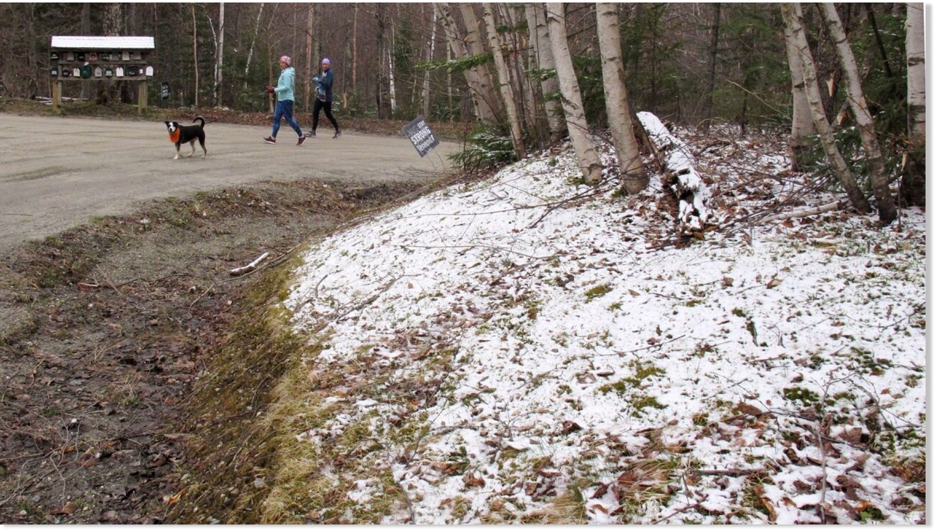
A dusting of snow covers a hillside in Stowe, Vt., on Tuesday May 5, 2020.

Residents across Northern New England woke up to early May snow on Tuesday, the first of several rounds of frozen precipitation before a colder blast expected Mother's Day weekend.

On Wednesday, a low-pressure system moving from the Midwest into the Mid-Atlantic brought rain and snow to parts of Pennsylvania and Western New York, according to Fox News senior meteorologist Janice Dean.

"As you go across the Great Lakes and the interior Northeast, we actually have wind chills in the freezing range," Dean said on "Fox & Friends."

Other snow showers were reported in parts of the White Mountains in New Hampshire, in areas of northern Vermont and parts of Maine.

Photos from near Stowe, Vermont, showed tree branches and hillsides covered by a light dusting of snow.

1588806732116.png
A dusting of snow covers tree branches in Stowe, Vt., on Tuesday May 5, 2020.

Frost advisories were posted Wednesday for areas of Western New York near the Great Lakes, as well as for the Hudson Valley.

The National Weather Service (NWS) office in State College, Pa. said that rain overspreading central Pennsylvania on Wednesday morning may mix with wet snow at higher terrain, but no accumulations are expected.

1588806788461.png
An Arctic blast is forecast to impact the Northeast for Mother's Day Weekend.

"Temperatures will only top out in the mid 40s, within just a few degrees of the record coldest high temperatures for May 6," the NWS tweeted.

As the storm system producing rain and snow in Pennsylvania moves off the coast, much cooler Arctic air will settle in behind it.

"It's gonna get colder as we head into the weekend, we're probably going to set quite a few record lows as we get into Friday and Saturday," Dean said.

The coldest air will arrive Friday night into Saturday morning, with the chilliest air expected from the Great Lakes and Appalachians to the Mid-Atlantic and Northeast.

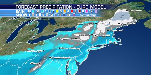
The Arctic air will lead to some snow across the interior Northeast, with heavier snow by Saturday across interior New England.
 

Cardinal

Chickministrator
_______________
Gonna drop to mid 40s here tonight. Hour and a half north of Atlanta. been windy, chilly all day.
 

TxGal

Day by day
Gonna drop to mid 40s here tonight. Hour and a half north of Atlanta. been windy, chilly all day.

Wow, that's pretty chilly for May there, I would think. I can recall one year around 1970 in Northern VA we had actual snow coming down in May. It didn't last long, and nothing stuck anywhere, but it was just weird.

This winter and into spring has actually been a little warmer here than normal. After last winter which was very wet and very cold, it has been a blessing. The downside, though, is that virtually none of our scores of fruit trees have any fruit. I'm guessing we didn't hit the needed chilling hours, even though our varieties are low chill types.
 
Soe of my favorites: The resilient gardener by Carol Deppe. IMO about the best out there for growing food to stay fed. She focuses on 5 crops: Corn, beans, eggs, potatoes and squash. THe Joy of Gardening by Dick Raymond. Book from the 80s on basic gardening. He sells the Troybilt tiller pretty hard but it is a good book. Eliot Colemans Four Season Harvest or Four Season Farm Gardeners Cookbook. Both get into gardening year-round in a cold climate with greens growing in greenhouse all year long. A great all around Book is Carla Emerys Encyclopedia of Country Living. Gives you a taste of everything. Also hit up your state extension service as they will have a lot of free info on growing different things in your area. Most of all try stuff. Don't hesitate to plant something because you are afraid of screwing up. Plant it screw up and learn. I would say pick a half dozen things and focus on those. Lear what you can and try it!!
Just a note; Troybilt tillers ain’t what they used to be.
 

TxGal

Day by day
The Oppenheimer Ranch Project has a new podcast out:

View: https://www.youtube.com/watch?v=yXlGaXrlBGc


‘Very Unusual’ Arctic Air Set To Hit Eastern US With Record-Low Temps & Snow for May - Asteroid?
3,205 views
•Premiered 6 hours ago

Run time is 21:36

‘Very unusual’: Arctic air hit Eastern US with record-low temps for May https://cnb.cx/2W9GpSb

Feeling like March in May: Mother's Day weekend could threaten parts of Va. with frosty, freezing lows https://bit.ly/2WAx58V
Snow And Record Cold? Welcome To May Connecticut https://bit.ly/2YG3EFf
Lehigh Valley may see record-low temperatures this weekend; ‘a very cold, nasty day’ expected Saturday https://bit.ly/2WyT7sH
Thunderstorms and Rain in the Plains and Mississippi Valley; Fire Weather Concerns in Four Corners https://www.weather.gov/
GFS Model Total Snowfall https://bit.ly/2WdjIwK
CMC Model Total Snowfall https://bit.ly/2YCVs8R
Bye, snow! This year could be earliest final freeze in Denver in 12 years = NOT https://bit.ly/2SJqsjF
Perth storm hits with force as fierce cold front cuts power to 55,000 homes in WA's south-west https://ab.co/2W86uBg
Worldwide Volcano News https://www.volcanodiscovery.com/volc...
Scientists explain magnetic pole's wanderings https://bbc.in/2A6ZT1r
Surprise asteroid EVADES Earth protection satellites in one of the closest flybys ever recorded https://bit.ly/2WaEBbJ
Steve Lekson to Give Virtual Chimney Rock Presentation https://bit.ly/3fuDUBy
Think Our Sun Is A Nice, Constant Star? Changes Might Be Coming https://bit.ly/2YHMreM
Impact of the ~ 2400 yr solar cycle on climate and human societies https://bit.ly/2SJqTdN
 

TxGal

Day by day

Polar vortex to bring bitter Arctic blast to East, rare May snowstorm as West faces scorching heat

By Travis Fedschun, Brandon Noriega | Fox News

National forecast for Thursday, May 7


Absent for the entire winter, the polar vortex is blasting in with bitter Arctic cold across the eastern U.S. for Mother's Day weekend, and setting the stage for a possible historic May snowstorm in the Northeast.

The National Weather Service's (NWS) Weather Prediction Center (WPC) said that an "unusual weather pattern evolving across North America," including an "unusually cold" air mass from eastern Canada, is making a late-season snowstorm "increasingly likely" for the interior Northeast.

"This is going to be a record-breaking weekend," Fox News senior meteorologist Janice Dean said Thursday on "Fox & Friends."

MAY SNOW REPORTED IN NEW ENGLAND AS UNSEASONABLY COLD HEADS TOWARD EAST

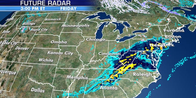
The cold air mass will cause rain from a system moving out of the Tennessee Valley to change to wet snow that could be heavy over the central Appalachians Friday. The storm system then intensifies further as it skirts the New England coast, according to the WPC.

The interior Northeast may see a historic May snowstorm as the polar vortex ushers in bitterly cold Arctic air.

The interior Northeast may see a historic May snowstorm as the polar vortex ushers in bitterly cold Arctic air. (Fox News)

"The potential for heavy snow over portions of the higher terrain of northern New England Friday into Saturday is increasing," the WPC said. "May daily snowfall records may be shattered, with several inches of snow possible."

Forecasters said that across the higher terrain of western and northern Maine, isolated snowfall could approach a foot, which would "shatter" May daily snowfall records.

View: https://twitter.com/NWSWPC/status/1258318289354346496


"Although daily snow in May across New England is not extremely rare, daily snowfall records for the month are possible," the WPC said.

A storm system moving out of the Tennessee Valley is bringing rain that will change over to snow as it meets with cold temperatures arriving in the Northeast.

A storm system moving out of the Tennessee Valley is bringing rain that will change over to snow as it meets with cold temperatures arriving in the Northeast. (Fox News)

Even higher elevations in the Mid-Atlantic could see snow. The NWS Baltimore/Washington D.C. forecast office said that a storm system on Friday ushering in cold air may lead to snow in higher elevations of northwestern Virginia, Western Maryland, and West Virginia.

"As colder air rushes in behind the front Friday evening, there will be a transition from rain to snow showers along the Allegheny Front with minor snow accumulations likely," forecasters said. "Further east, not expecting accumulating snow, however some wet flakes mixing in remains a possibility along and west of the Blue Ridge."

An Arctic blast is forecast to impact the Northeast for Mother's Day Weekend.

An Arctic blast is forecast to impact the Northeast for Mother's Day Weekend. (Fox News)

Some snowflakes could reach areas closer to Washington, D.C., early Saturday morning. But the chance of snow in the district is quite low, according to FOX5, which notes that the nation's capital has never seen measurable snow in May, as far back as the 1880s.

NORTHEAST TO SEE 'SEVERAL ROUNDS OF SNOW' AS ARCTIC BLAST PUSHES IN WHILE SOUTHWEST FACES MORE RECORD HEAT

For those who do not see snowfall, a chilly rain is expected Friday into Saturday.

Bitter cold temperatures are forecast for Mother's Day weekend.

Bitter cold temperatures are forecast for Mother's Day weekend. (Fox News)

Besides the threat of snow, the eastern third of the country will get record-low temperatures, with the Great Lakes and the Northeast seeing the coldest conditions.

The coldest air will arrive by Saturday morning.

The coldest air will arrive by Saturday morning. (Fox News)

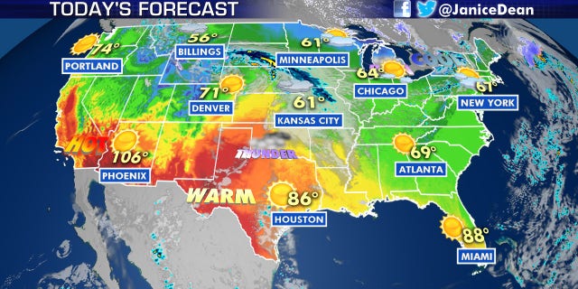
Temperatures are forecast to be higher in Fairbanks, Alaska, than in New York City, Philadelphia, Cleveland, and even Atlanta over the weekend. Widespread record low temperatures will span as far south as Alabama and Mississippi on Saturday. A high of 80 degrees is expected in Fairbanks on Mother's Day.

Record-cold temperatures may be broken on Saturday due to the blast of Arctic. air.

Record-cold temperatures may be broken on Saturday due to the blast of Arctic. air. (Fox News)

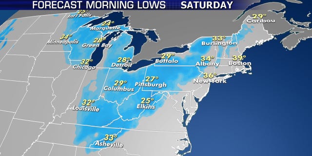
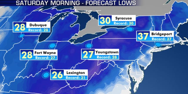
Records could be broken on Saturday morning in Syracuse, New York; Youngstown, Ohio; Lexington, Kentucky; Bridgeport, Connecticut; Fort Wayne, Indiana; and Dubuque, Iowa.

“The potential for record lows across portions of the Great Lakes and the Northeast -- so something to, you know, remember Mother's Day by," Dean said Thursday.

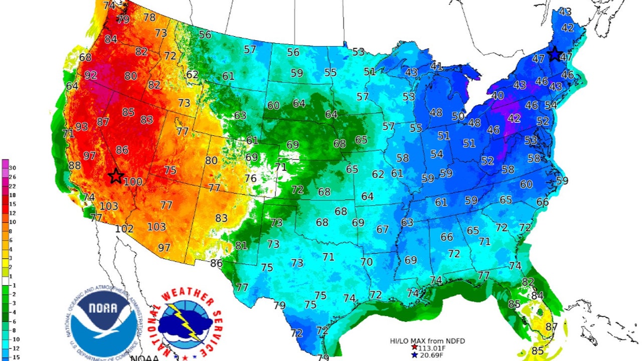
A contrast between temperatures on the West and East Coast on Saturday as a portion of the polar vortex brings bitter cold air to the Northeast.

A contrast between temperatures on the West and East Coast on Saturday as a portion of the polar vortex brings bitter cold air to the Northeast. (NWS WPC)

Frost advisories, freeze warnings, and freeze watches already stretch across the Great Lakes into the Ohio River Valley and high-elevation locations in the Southeast.

“Over some areas, this cold surge would lead to a late frost/freeze where the growing season has already started,” the NWS said.

Climatologist Judah Cohen said on Twitter that a strong blocking near Alaska, which is giving the state the warm temperatures, is forcing the rare appearance of the polar vortex in the Northeast and the possibly historic snowstorm.

View: https://twitter.com/judah47/status/1257344171305820162


This rare visit from the polar vortex over the weekend will only last for Mother's Day weekend before temperatures eventually get milder next week.

Record heat continues out West

As the eastern half of the country bundles up for the cold blast, the opposite is happening out west.
Hot weather continues out West on Thursday, as the Northeast braces for a shot of Arctic air.

Hot weather continues out West on Thursday, as the Northeast braces for a shot of Arctic air. (Fox News)

Near-record heat is expected again for Southern California, the Desert Southwest and the southern Rockies.
Strengthening high pressure will mean excessive heat and wildfire threats across the Southwest into Southern California, with above-average temperatures expanding into the Pacific Northwest this weekend, according to the WPC.

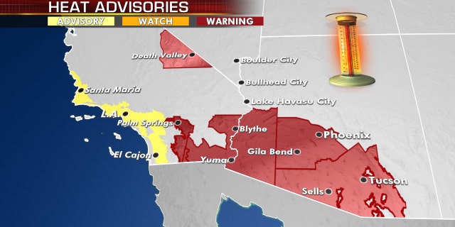
Excessive heat warnings and advisories are in effect out west as hot weather continues.

Excessive heat warnings and advisories are in effect out west as hot weather continues. (Fox News)

Triple-digit temperatures on Thursday could break records in Southern California, southern Arizona, southern New Mexico and far west Texas.

In addition to the heat, fire risk will be very high Thursday over much of the southern Rockies as a low-pressure system that could bring severe weather develops over the central Plains.
 

TxGal

Day by day

Victoria – Coldest in 60 years forecast

May 7, 2020 by Robert

Of course the media calls it a ‘cold snap.’

A complex multi-centred low pressure system has converged on Australia, causing both record-breaking rain and in Victoria and the coldest in 60 years.
April 30 was set to be the coldest day, with parts of northern South Australia, northwest NSW and southwest Queensland forecast to record their coldest April day since the 1960s or 70s.
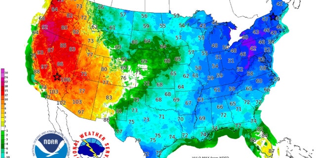
Meteorologist Dr Adam Morgan said maximum temperatures could plunge between 8C-14C below average for this time of year.

“This is a very strong and widespread cold outbreak across southeast Australia,” he said.

Meanwhile Victoria has been pummeled by record-breaking rainfall.

Melbourne’s 2020 totals have already reached almost 400mm — surpassing the total amount for last year.

The Bureau of Meteorology also warned blizzards were likely in alpine areas above 1800m from Thursday evening.

Cold snap to bring lowest temperatures in decades

Queensland cold breaks 30-year-old record in state’s south

In outback Queensland, Thargomindah yesterday broke the 1989 record for the coldest April day when the maximum temperature only reached 18.5C.

Birdsville also beat its 2015 record with a 20.6C day, and the Ballera Gas Fields had its coldest April day, with 18.9C, since monitoring began there 18 years ago.

Queensland cold weather snap breaks 30-year-old record in state's south - ABC News

Thanks to Thomas Krassman for these links
 

Martinhouse

Deceased
Ice Age Farmer has a new podcast coming out at 8:30 this evening.

It is almost an hour long.....I haven't checked the details yet.

It should be a good one!
 

TxGal

Day by day
Ice Age Farmer has a new podcast coming out at 8:30 this evening.

It is almost an hour long.....I haven't checked the details yet.

It should be a good one!

Excellent, thank you!! I probably won't be up that late to post it (got up early to do some running around), but I'll bring it in tomorrow morning if someone else doesn't do it first.
 

packyderms_wife

Neither here nor there.
Soe of my favorites: The resilient gardener by Carol Deppe. IMO about the best out there for growing food to stay fed. She focuses on 5 crops: Corn, beans, eggs, potatoes and squash. The Joy of Gardening by Dick Raymond. Book from the 80s on basic gardening. He sells the Troybilt tiller pretty hard but it is a good book. Eliot Colemans Four Season Harvest or Four Season Farm Gardeners Cookbook. Both get into gardening year-round in a cold climate with greens growing in greenhouse all year long. A great all around Book is Carla Emerys Encyclopedia of Country Living. Gives you a taste of everything. Also hit up your state extension service as they will have a lot of free info on growing different things in your area. Most of all try stuff. Don't hesitate to plant something because you are afraid of screwing up. Plant it screw up and learn. I would say pick a half dozen things and focus on those. Lear what you can and try it!!

Please post this in the Gardening forum here at TBK!!! TIA.
 

Martinhouse

Deceased
Well, I was able to make all five hens get off that big nest of eggs today. Must have been lots of egg smashing going on and the two to three dozen remaining eggs look pretty smeared up. I suspect they will all be duds. I'll give it a few more days and then I'll get rid of all of those eggs. After that, if one or two hens start setting again, I'll definitely separate them into pet carriers and then try to get the other hens to lay elsewhere.

I would really like a big hatch of chicks, but I also need to be gathering eggs before too much longer..
 

Dennis Olson

Chief Curmudgeon
_______________
NOTE: After a discussion in the Lounge, I’ve “un-deleted” the original thread. For whatever reason, von Koehler got all butt-hurt over that thread being open. No idea why. I overreacted by deleting it, so it’s been brought back from the dead. Feel free to copy anything from the old thread to this one EXCEPT any “creative content“ written by von Koehler.

Dennis
 

summerthyme

Administrator
_______________
Carol... multiple hens on one nest almost never work. If you get one acting broody, leave her where she is just long enough to collect 10 (many more than that often ends up with a poor hatch as the hen rotates eggs from the outside in so they all stay warm, but if she has too many, they all get chilled too much instead) fresh (never refrigerated) eggs. Then set up a nest in a dog crate or other secure area, and move her to it after dark. I usually put food and water in the crate and shut them in for 48 hours... then open the door. Generally, that's long enough for them to adapt to the new spot.

If you think you will have another broody hen shortly, rather than refrigeration your eggs immediately, start a rotating basket of unwashed fresh eggs... leave it in a fairly cool spot if possible, but even on the counter will work unless your house is really hot. Every couple days (or however long it takes to have 10-12 eggs), wash (if necessary) those eggs and refrigerate, and replace with freshly gathered ones.

This doesn't really shorten the refrigerated shelf life much (maybe a week), but it will give you the best chance of getting a clutch of chicks when a hen gets it into her tiny brain that she needs a family.

Summerthyme
 

Martinhouse

Deceased
Summerthyme, I never wash my eggs until I'm ready to use them. They last lots longer for me that way. And there are always plenty on the counter. I just put them in the fridge before they start getting old. My house is never very warm, fortunately for the eggs and unfortunately for my comfort.

Since these hens are so persistent about using the one corner of the pen for setting, I'm going to simply shoo the hen away and put the carrier in that corner. I've gotten the hens used to me fiddling around in there and I suspect she'll go back to the nest as soon as I walk away from it. If she doesn't, I'll have to catch her and cram her in the carrier and then put the eggs in after her. I've done this before and after she settles down, she'll pull those eggs under her and sit there looking indignant until she gets used to her "improved" nest. Then I'll relocate the carrier in case the other hens still insist on using that corner. I might even end up with three or four carriers before all is done!

I do wish I had some sort of covered dog kennel to put the carriers in. But I don't so I'll just have to make do without one as best I can. Even if I had some of the bigger rabbit cages, I'd still have to find a safe dry place to keep them. The greenhouse would be perfect, but it gets too hot in there.

I'm thinking having lots of little chickens might be a good trading item before too much longer. And I do intend to butcher and can any extra roosters for cat food.
 

TxGal

Day by day
NOTE: After a discussion in the Lounge, I’ve “un-deleted” the original thread. For whatever reason, von Koehler got all butt-hurt over that thread being open. No idea why. I overreacted by deleting it, so it’s been brought back from the dead. Feel free to copy anything from the old thread to this one EXCEPT any “creative content“ written by von Koehler.

Dennis

Thank you, Dennis!! Lots of good history there for access and review, and saves a boatload of time trying to bring everything over to the thread, part II.
 

TxGal

Day by day
Below is the new Ice Age Farmer podcast posted last evening:

View: https://www.youtube.com/watch?v=4lBNUAx9ILU


The Technocratic, Transhumanist Total Takeover of Food
13,804 views
•Premiered 11 hours ago

Run time is 52:16

To understand the meat shortages and push for fake meat, we must appreciate the technocrats' agenda for a totalitarian, transhumanist future -- and use of FOOD as a weapon to achieve it. Christian looks more deeply into the genesis of this agenda, the history of Rockefeller takeover of agriculture and seeds, the more recent marriage of Big Ag and Big Tech ("AgTech"), and the new AI systems being deployed to achieve "perfect information awareness" -- and total control.
 
Top