
You are using an out of date browser. It may not display this or other websites correctly.
You should upgrade or use an alternative browser.
You should upgrade or use an alternative browser.
Solar Grand Solar Minimum part deux
- Thread starter Dennis Olson
- Start date
-
- Tags
- grand solar minimum
northern watch
TB Fanatic
SCIENTISTS ACKNOWLEDGE THEY GOT IT WRONG, THAT THE PEAK OF SOLAR CYCLE 25 IS FAST APPROACHING
NOVEMBER 1, 2023 CAP ALLONElectroverse
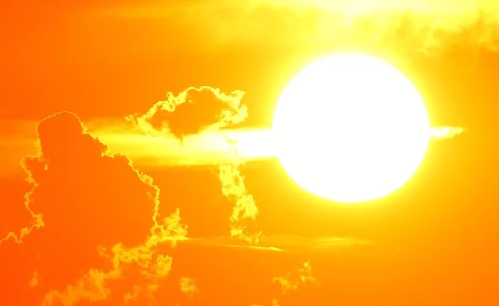
NOAA’s Space Weather Prediction Center has released a “revised prediction” for the current solar cycle, which states that the upcoming solar maximum will arrive sooner and be more explosive than they initially forecast, reports Live Science.
Scientists forecasting solar weather now say that we are fast approaching an explosive peak in solar activity.

Nearing solar maximum the sun’s magnetic field lines become ‘tangled’ which generates more spots, flares and CMEs [NASA/SDO/AIA/LMSAL]
The sun’s current cycle, Solar Cycle 25, officially began in early-2019.
At the time, NOAA’s Space Weather Prediction Center (SWPC) predicted that Solar Cycle 25 would most likely peak at some point in 2025 and be underwhelming compared with average cycles, much like its predecessor, Solar Cycle 24.
They were wrong, SC25 ramped-up quicker than expected and is now threatening to end prematurely (potentially with a bang).
On October 25, the SWPC finally issued a “revised prediction” for Solar Cycle 25 and acknowledged that its initial estimations were “no longer reliable enough for SWPC’s customers”–speaking to its private space exploration and satellite companies.
The new update states that “solar activity will increase more quickly and peak at a higher level” than initially predicted and that solar maximum could come as early as January next year and no later than October.
Also worth noting, despite SC25’s stronger than expected start, the cycle is still running historically weak, and will comfortably conclude as such if its max does indeed arrive promptly:

Solar Cycle 25 (green line) compared with the previous four cycles [solen.info]
A more active solar cycle peak could lead to disruptions here on Earth.
As I reported Tuesday, this week marks the 20th anniversary of the Great Halloween Storm of 2003.
Solar Cycle 23 was winding down this time 20 years ago, and space weather forecasters were talking about how quiet things would soon become. Suddenly, the sun unleashed two of the strongest solar flares of the Space Age: an X17 flare on Oct 28, followed by an X10 on Oct 29, 2003. Both hurled fast-moving Coronal Mass Ejections (CMEs) directly toward Earth.
Many Earth-orbiting satellites experienced data outages, reboots and even unwanted thruster firings. Some operators simply gave up and turned their instruments off. Many of Earth’s satellites were actually ‘lost’.
In a 2020 paper entitled “Flying Through Uncertainty,” USAF satellite operators recalled how “the majority of satellites (in low Earth orbit) were temporarily lost, requiring several days of around-the-clock work to reestablish their positions.”
Most satellite operators today have never experienced anything like the Halloween storms. “That’s a problem,” writes Dr Tony Phillips of spaceweather.com, “because the number of objects they need to track has sharply increased.”
Since 2003, the population of active satellites has ballooned to more than 7,000, with an additional 20,000+ pieces of debris larger than 10 cm. Losing track of so many objects in such a congested environment could theoretically trigger a cascade of collisions, rendering low Earth orbit unusable for years following an extreme geomagnetic storm.
Given our ever-increasing dependence on this tech, as well our planet’s ever-waning magnetic field strength, that’s scary.
A more active solar maximum poses a “larger hazard for these critical technologies and services,” NOAA representatives wrote in their updated forecast. Also, wildlife experts have warned that a more active solar maximum could disorient animals that rely on Earth’s magnetic field to navigate, such as large whales and migrating birds.
Moving forward, SWPC will now shift to a novel, more flexible forecast system to be updated at the start of every month.
“We expect that our new experimental forecast will be much more accurate than the 2019 panel prediction and, unlike previous solar cycle predictions, it will be continuously updated on a monthly basis as new sunspot observations become available,” explained Mark Miesch, a solar physicist at the Cooperative Institute for Research in Environmental Sciences at the University of Colorado Boulder and lead researcher at SWPC.
“It’s a pretty significant change.”
Scientists Acknowledge They Got It Wrong, That The Peak Of Solar Cycle 25 Is Fast Approaching - Electroverse
Latest SWPC update states that solar maximum could come as early as January (2024).
northern watch
TB Fanatic
GLOBAL VOLCANIC UPTICK AND THE POTENTIAL IMPLICATIONS: NEW STUDY SHOWS HOW HISTORICAL ERUPTIONS TRIGGERED GLOBAL COOLING
NOVEMBER 14, 2023 CAP ALLONElectroverse
GLOBAL VOLCANIC UPTICK
News of volcanoes popping off/threatening to pop off are doing the mainstream rounds this week, and while it makes for good ‘clicks’ I am not yet seeing anything overly concerning–over localized hazards that is, in Iceland most notably.Residents of Iceland’s southwestern town of Grindavik have briefly been allowed back to their homes to collect belongings due to a hush in seismicity. Despite the reprieve however, a volcanic eruption is still expected, warn officials.
Pedrag, a native Serb who has lived in Iceland for many years, was one of those who fled the town with his wife.
“If you talk to Icelandic people who have lived there all their lives, they say they have never felt something like that”.
Another resident, Gisli Gunnarsson, said he feared he might never see his home again and called the situation “grim”.
Volcanologists say that a 15km-long (9 mile) river of magma running under the Reykjanes Peninsula is very active. Latest updates could indicate a smaller impending eruption than was previously thought, but one that would still put the town in real danger.
The river runs under Iceland as well as part of the Atlantic Ocean, and the impact of an eruption on the country –and further afield with regard to aviation and potential cooling– will depend on where exactly the magma breaches the surface.
One of Iceland’s most extensive eruptions occurred in 1783 when a flood of lava lasted for eight months. This produced extensive sulphur clouds which hung over Northern Europe for six months and caused an estimated cooling of 1.3C for the following two years.
Dr Ilyinskaya, who is in regular contact with geologists on the ground, said: “It looked concerning back on Friday and Saturday that we could have something of that scale … That is not the situation that is likely at the moment.”
Dr Bill McGuire, professor emeritus of Geophysical & Climate Hazards, UCL, said: “Grindavik is very close to the position of the new fracture, and its survival is far from assured. Everything depends upon where magma eventually reaches the surface, but the situation doesn’t look good for the residents of the town.”
Despite initial concerns of a much wider eruption now receding, officials are continuing to monitor the situation on a “minute by minute” basis things could change quickly.
The area had remained dormant to volcanic activity for 800 years before a 2021 eruption.
Thor Thordason, professor of volcanology at the University of Iceland, said that the magma is now less than 800m (2,600ft) below the surface and that an eruption appeared imminent.
“Unfortunately, the most likely eruption side appears to be within the boundary of the town of Grindavik,” he pointed out.
Other than Reykjanes volcano in southwest Iceland, we also see Italy’s Mount Etna establishing a new eruptive phase, as well as sizable eruptions at Sabancaya (Peru), Popocatépetl (Central Mexico), Klyuchevskoy (Kamchatka/Russia) and Sakurajima (Japan).
Again though, nothing overly concerning — not yet anyway.

Erupting volcanoes (red), and volcanoes with a warning/minor activity (orange) [volcanodiscovery.com].
Volcanic eruptions are one of the key climatic forcings that will drive Earth into its next bout of global cooling.
They have been shown to increase in both number and explosivity during bouts of prolonged low solar activity. This is thought to be tied to an influx of cosmic rays (CRs) penetrating and exciting silica-rich magma.
During solar minimums the sun’s magnetic field weakens and the outward pressure of the solar wind decreases .
Ths allows more CRs to enter the inner solar system, including our own planet’s atmosphere, agitating magma and sending volcanoes a-popping.
NEW STUDY SHOWS HOW HISTORICAL ERUPTIONS TRIGGERED GLOBAL COOLING
A new international study led by Scotland’s University of St Andrews reveals historical high latitude volcanic eruptions caused dramatic global cooling.“High sensitivity of summer temperatures to stratospheric sulfur loading from volcanoes in the Northern Hemisphere” is led by the School of Earth and Environmental Sciences at St Andrews with international colleagues from Switzerland and the United States, and was published in the Proceedings of the National Academy of Sciences (PNAS) on November 6.
Unusually cold decades of the past, such as the 540s, 1450s, and 1600s, are associated with large volcanic eruptions, resulting in volcanic sulfate particles reflecting incoming sunlight. However, the source of the volcanic eruptions and the amount of sulfate they injected into the upper atmosphere has been unknown.
To address this, the international team of researchers, led by Dr. Andrea Burke, studied sulfur isotopes in ice cores from Greenland and Antarctica. The isotopes provided a fingerprint of the fraction of the sulfate that reached the stratosphere.
The results, correlated with tree-ring data, reveal that the largest historical cooling periods were due to volcanic eruptions at high latitudes. It also show that the amount of sulfate injected into the stratosphere by these eruption events may have been around half that previously estimated, suggesting that summer temperatures may be highly sensitive to high latitude volcanic eruptions.

Volcanic events of the 530s (Left, A–E), mid-1450s (Middle, F–J), and 1600s (Right, K–O). (A, F, and K) NH summer temperature anomaly relative to the three-year mean prior to the eruption reconstructed from tree-rings (B, G, and L) Concentration of sulfur (ppb) in the Tunu2013 ice core from Greenland (blue) and the B40 ice core from Antarctica (pink).
The line is from continuous measurement on the ice core , and squares are from the discrete concentrations made on the isotope samples. (C, H, and M) δ34S of sulfate and (D, I, and N) Δ33S of sulfate from ice core samples from Tunu2013(blue) and B40 (pink). Measured values are represented by x’s (Tunu2013) or +’s (B40). For samples with more than 65% volcanic sulfate, estimates of the isotopic composition of the volcanic sulfate from isotope mass balance are also plotted in blue circles (Tunu2013) or pink triangles (B40). (E, J, and O) Continuous S concentration (ppb) from Tunu2013 ice core as in (B, G, and L), with the filled blue area as the estimate of the fraction of the sulfate coming from the stratosphere based on isotope mass balance The dashed line represents 1σ uncertainty on the fraction of stratospheric sulfate as estimated from Monte Carlo simulations. Credit: Proceedings of the National Academy of Sciences (2023). DOI: 10.1073/pnas.2221810120
“Our data show that when Earth’s climate gets altered, other parts of the climate system can kick in to strongly amplify this initial change,” said Dr. Burke.
“High latitudes feel these amplified climate changes particularly strongly.”
Global Volcanic Uptick And The Potential Implications: New Study Shows How Historical Eruptions Triggered Global Cooling - Electroverse
'...the largest historical cooling periods were due to volcanic eruptions at high latitudes'.
Last edited:
straightstreet
Life is better in flip flops
Philippines EQ this morning.
I've read Philippines tv is reporting a 7.2. USGS says 6.7.
I've read Philippines tv is reporting a 7.2. USGS says 6.7.
northern watch
TB Fanatic
From my email inbox The Old Farmer's Almanac November 20 2023

northern watch
TB Fanatic
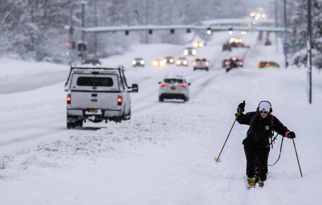
More than a foot of snow, 100 mph wind gusts possible as storm approaches Sierra Nevada
FILE - A car passes a caution sign as heavy snow falls on the Mt. Rose Highway near Reno, Nev., on Dec. 1, 2022. The National Weather Service issued advisories Saturday, Nov. 18, 2023, along the California-Nevada line ahead of an early winter storm that could bring more than a foot (30 centimeters) of snow to the upper elevations of the Sierra and winds gusting up to 100 mph (160 kph) over ridgetops. The winter weather advisories, in effect from 4 p.m. Saturday through 4 a.m. Sunday, stretched from the Lake Tahoe area near Reno to south of Yosemite National Park, including Mammoth Lakes, California. (Jason Bean/The Reno Gazette-Journal via AP, File)
Updated 8:53 AM EST, November 19, 2023
RENO, Nev. (AP) — The National Weather Service issued advisories Saturday along the California-Nevada line ahead of an early winter storm that could bring more than a foot (30 centimeters) of snow to the upper elevations of the Sierra and winds gusting up to 100 mph (160 kph) over ridgetops.
The winter weather advisories, in effect from 4 p.m. Saturday through 4 a.m. Sunday, stretched from the Lake Tahoe area near Reno to south of Yosemite National Park, including Mammoth Lakes, California.
Winter storm approaching:
- The National Weather Service has issued advisories along the California-Nevada line ahead of an early winter storm that could bring more than a foot of snow to the top of the Sierra and winds gusting up to 100 mph.
- The advisories are in effect from 4 p.m. Saturday through 4 a.m. Sunday.
- NWS says snow could fall at rates of 1 to 2 inches an hour in some places.
“Plan on slippery road conditions and poor visibility with snowfall rates of 1 to 2 inches per hour (2.5 to 5 centimeters) in heavier bands,” the weather service in Reno said.
Strong winds could cause tree damage, blowing snow and hazardous boating conditions on Lake Tahoe with waves 2 to 4 feet (60 to 122 centimeters) high, it said.
More than a foot of snow and 100 mph wind gusts possible as storm approaches Sierra Nevada
The National Weather Service issued advisories Saturday along the California-Nevada line ahead of an early winter storm.
 apnews.com
packyderms_wife
Neither here nor there.
Just heard on the radio, 1040 AM out of Des Moines, IA, that the entire soy bean crop in Brazil was destroyed by bad weather and they're not sure if they will have enough time for harvest if they can get in and replant this week.
northern watch
TB Fanatic
From my email inbox The Old Farmer's Almanac November 21 2023

jed turtle
a brother in the Lord
WELL, yesterday was cold and clear, but today has started with a half inch of the first snow to accumulate on the ground and then a dark, cold rain for the rest of the day. But they got 5” of snow in central Maine a one hundred miles north of here. Fairly typical for Thanksgiving weather around here.
northern watch
TB Fanatic
FUKUOKA, JAPAN RECORDS EARLIEST SNOW IN 40 YEARS; BLIZZARDS KILL 2 IN BULGARIA; CALIFORNIA LOGS A FOOT; ANCHORAGE BREAKS NOVEMBER SNOWFALL RECORD; + WAPO ON DAMAGE LIMITATION
NOVEMBER 20, 2023 CAP ALLONElectroverse
FUKUOKA, JAPAN SEES EARLIEST SNOW SINCE IN 40-YEARS
On Sunday, November 19, Fukuoka Prefecture, on the northern shore of Japan’s Kyushu Island, posted early snowfall.The record cold and snow noted in Eastern Asia over the past few weeks –namely in Northeast China, Mongolia and Eastern Siberia– has since traversed the Sea of Japan to deliver the north of the country some exceptionally early flurries.
The city of Fukuoka has posted its earliest snow since November 1983, according to the Japanese Meteorological Agency. And ooking ahead, there’s much more where that came from, and for the majority of Japan, too:

GFS Total Snowfall (cm) Nov 20 – Dec 6 [tropicaltidbits.com]
BLIZZARDS KILL 2 IN BULGARIA
Plunging temperatures, strong winds and heavy rain/snow hit large parts of Bulgaria on Sunday causing severe damage, disrupting power supplies, and claiming the lives of at least two people.Eastern Bulgaria was hit hardest, with residents saying they had never before endured such extreme weather.
A state of emergency was declared in the Black Sea city of Varna, which saw torrential rains turn to heavy snow and blizzards.
Fallen trees and drifting snow blocked key roads.
The mayor’s office reported power disruptions in all boroughs of Varna, and called on residents to stay home.

A car is left on the road near town of Dobrich, Bulgaria, Sunday, Nov. 19 2023 [Bulgarian News Agency]
Varna police reported a woman died after being struck by a falling tree branch.
While in the capital city of Sofia, a man died Saturday after his car skidded into a fallen tree.

Policeman walks in front of a bus gone of the road near town of Dobrich, Bulgaria, Sunday, Nov. 19 2023 [Bulgarian News Agency]
Bulgarian meteorologists issued warnings for dangerous weather for most of the country’s east on Sunday, including for strong winds and blowing snow.
The polar front caused damage across the Black Sea, too, and into the likes of Turkey.
Here, AFAD (Turkey’s emergency agency) issued severe warnings for 72 of the country’s 81 provinces.
Turkish Airlines canceled hundreds of flights from Istanbul’s two airports on Sunday alone. And the heavy accumulating snow led to travel disruptions on the likes of the Istanbul-Ankara highway.
Away from Istanbul, snow depths exceeded 50cm (1.64ft) across the likes of Uludag.
The snow is spreading further east into the likes of Western/Central Asia, from Iraq to northern India.
See the latest GFS run below–and also note the impressive totals expected over central Russia (Siberia):

GFS Total Snowfall (cm) Nov 20 – Dec 6 [tropicaltidbits.com]
CALIFORNIA LOGS A FOOT
Heavy snow clipped California’s higher elevations over the weekend, with more than a foot accumulating on the mountains.Along the California-Nevada border, an early winter storm brought a foot of snow to Mt. Rose Ski Tahoe, another 7 inches to Mammoth Mountain ski base, and 4 inches to Palisades. Flakes also settled below 5,000ft (1,500m) at the NWS office in Reno.
A winter weather advisory was put in effect for the Ruby Mountains and East Humboldt Range as total snow accumulations surpassed 18 inches there.
“If you’re planning to travel into the Sierra, Tahoe Basin or Mono Lake, carry your winter travel kit and check the roads before you go,” warned NWS meteorologist Edan Lindaman.
This is a far cry from what California’s arm of the global warming cabal foretold would be occurring by now. Five years ago, on November 18, 2018, then Governor of California Jerry Brown prophesied that the coming climate disasters will convert even the worst skeptics within five years.
Brown, on the behest of his backers, claimed that ever-increasing temperatures would lead to more wildfires, droughts and hurricanes, and a decrease in snowfall. But Brown was wrong.
Starting with temperatures, below is a look at the U.S. Climate Reference Network for October 2023:

Regarding wildfires, they have been found to be decreasing:

Hurricanes?
No trend:

Hurricane data reveal no trend [more here]
And with regards to snowfall, well, all-time record-smashing snow was the story last season, when at least 20 Western U.S. ski resorts posted their snowiest years in recorded history…
…snow that is again commencing early this new season:

GFS Total Snowfall (inches) Nov 20 – Dec 6 [tropicaltidbits.com]
Brown’s agenda-driving calls for ‘mega-drought’ and ‘the end of snow’ have been proven backwards.
And to those catastrophists now dutifully switching to a ‘warming = increased snowfall’ line of thinking, you also need a re-group-think because the data aren’t showing an increase in precipitation (rain); the trend in SoCal, if anything, is actually down:


ANCHORAGE BREAKS NOVEMBER SNOWFALL RECORD
Anchorage, Alaska has set as new November snowfall record, breaking the 38.8 inches set in 1994.The benchmark was busted on Friday, with snow that took this month’s totals to an unprecedented 39.1 inches:

Given that a third of the month remains, and that more snow is in the forecast, the record could approach 50 inches.
Anchorage has endured record-breaking snowstorms in recent weeks.
Some areas outside the city copped more than 2 feet in just two days earlier in the month.
Anchorage received 9 inches of snow in 24 hours on Nov 8, breaking the daily record of 7.3 inches set back in 1982.
Another 8.2 inches then piled up Thursday, which also broke the daily record for Nov 9, the 7.1 inches which had stood since 1956. By late Thursday, Anchorage had a 21-inch snow depth — the city’s greatest-ever snow depth so early into a season.
And the snow kept falling.
WAPO ON DAMAGE LIMITATION
2022 Nobel prize winner John Clauser is giving the AGW Party a real headache.The Washington Post is the latest corporate media outlet charged with damage limitation: “He won a Nobel Prize. Then he started denying climate change,” reads their headline dated Nov 16.
John Clauser shared the Nobel in physics last year. Now he’s a self-described ‘denier’ of the overwhelming scientific consensus on a warming planet, writes activist-journalist Maxine Joselow.
It might have seemed like a fringe event except for one speaker’s credentials, continues Joselow, speaking to a climate conference held last week. John F. Clauser shared the Nobel Prize in physics last year before declaring Tuesday that “there is no climate crisis” — a claim that contradicts the overwhelming scientific consensus.
“There was overwhelming consensus that what I was doing was pointless [in the 1970s], Clauser said in an interview after the conference. “It took 50 years for my work to win the [Nobel] prize. That’s how long it takes for opinions to change.”
Joselow failed to recognize the point Clauser was making, opting to blindly politicize his stance instead.
Clauser bragged that he met privately with President Biden in the Oval Office last year, when the 2022 Nobel Prize winners were invited to the White House, goes Joselow’s hit piece. He said he criticized Biden’s climate and energy policies, to which he said the president replied: “Sounds like right-wing science.”
This is all the WaPo has to discredit Dr Clauser; that is, ‘Biden called his views right-wing’. But to start from the position that a scientific view differing from your own must be ideologically driven is the clearest sign of desperation.
The climate cabal are scraping the bottom of the barrel. It’s amusing to watch.
Joselow includes the views of NOAA’s Nadir Jeevanjee, who laments: “There is a skeptical streak in the physics community regarding climate science.” Huh. So, on the one hand you have the WaPo asserting that there is an ‘overwhelming consensus’ on the subject, while on the other they’re admitting that a ‘skeptical streak’ runs through the physics community.
What an admission.

I wonder how many paint-tossing alarmists were aware of that?
Fukuoka, Japan Records Earliest Snow In 40 Years; Blizzards Kill 2 In Bulgaria; California Logs A Foot; Anchorage Breaks November Snowfall Record; + WaPo On Damage Limitation - Electroverse
"He won a Nobel Prize. Then he started denying climate change," reads the increasingly-disconnected and desperate Washington Post.
Last edited:
northern watch
TB Fanatic
From my email inbox The Old Farmer's Almanac November 25 2023

northern watch
TB Fanatic
From my email inbox The Old Farmer's Almanac November 26 2023

northern watch
TB Fanatic
From my email inbox The Old Farmer's Almanac November 28 2023

Last edited:
northern watch
TB Fanatic
From my email inbox The Old Farmer's Almanac November 29 2023

jed turtle
a brother in the Lord
These photos are great! It makes it easy to believe that Earth is still somewhat the paradise that was originally created.
northern watch
TB Fanatic
From my email inbox The Old Farmer's Almanac December 1 2023

northern watch
TB Fanatic
From my email inbox The Old Farmer's Almanac December 2 2023

northern watch
TB Fanatic
From my email inbox The Old Farmer's Almanac December 3 2023

northern watch
TB Fanatic

northern watch
TB Fanatic
Temperatures in Siberia dip to minus 50 Celsius as record snow blankets Moscow
ReutersDecember 4, 2023 1:16 AM EST
Updated 6 hours ago

A communal worker cleans snow at the Exhibition of Achievements of National Economy (VDNH) during a heavy snowfall in Moscow, Russia December 3, 2023. REUTERS/Maxim Shemetov Acquire Licensing Rights
MOSCOW, Dec 4 (Reuters) - Temperatures in parts of Siberia plummeted to minus 50 degrees Celsius (minus 58 degrees Fahrenheit) while blizzards blanketed Moscow in record snowfall and disrupted flights as winter weather swept across Russia.
In the Sakha Republic, located in the northeastern part of Siberia and home to Yakutsk, one of the world's coldest cities, temperatures fell below minus 50 C, according to the region's weather stations.
An abnormally early cold snap in Sakha pushed temperatures to even lower than minus 50 C in several areas of Sakha, a vast region just a little smaller than India.
Almost all of Sakha is located in the permafrost zone. In the region's capital, Yakutsk, which lies some 5,000 km (3,100 miles) east of Moscow, the temperature was around minus 44 C to minus 48 C.
Temperatures of minus 50 C have become less common in recent years because of climate change, with permafrost showing increasing signs of thawing.
In the Russian capital, some of the biggest snowfalls ever seen caused delays at some airports on Monday, with runways covered in thick snow.
At least 54 flights were delayed and five more were cancelled at the capital's three largest airports, the RIA news agency reported.
Temperatures in Moscow were forecast to fall to about minus 18 C later this week.
Reporting by Lidia Kelly in Melbourne and Guy Faulconbridge in Moscow; Editing by Jamie Freed
/cloudfront-us-east-2.images.arcpublishing.com/reuters/P2DA2H33VZKR5HDNKUA62SWJEQ.jpg)
Temperatures in Siberia dip to minus 50 Celsius as record snow blankets Moscow
Temperatures in parts of Siberia plummeted to minus 50 degrees Celsius (minus 58 degrees Fahrenheit) while blizzards blanketed Moscow in record snowfall and disrupted flights as winter weather swept across Russia.
 www.reuters.com
northern watch
TB Fanatic
Heavy snowfall hits Moscow as Russian media report disruption on roads and at airports
Russian officials and media say that heavy snowfall that hit Moscow has disrupted traffic on roads and flights in and out of three airportsBy The Associated Press
December 4, 2023, 7:26 AM
")
People swim in ice water celebrating opening of the 65th winter swimming season of the Moscow Walrus Club in Serebryany Bor during heavy snowfall in Moscow, Russia, Sunday, Dec. 3, 2023. A record snowfall has hit Russia's capital bringing an additional 10 cm to already high levels of snow and causing disruption at the capital's airports and on roads. (Pelagia Tikhonova/Moscow News Agency via AP)
MOSCOW -- Heavy snowfall has hit the Russian capital, disrupting traffic on roads and flights in and out of three Moscow airports, officials and media reported on Monday.
The snowfall that began Sunday and continued overnight has brought an additional 23 centimeters (nine inches) to already high levels of snow in Moscow, according to deputy mayor Pyotr Biryukov. About 135,000 people and 18,000 pieces of equipment were involved in the snow-clearing effort.
Nearly 200 trucks got stuck in the snow over the past 24 hours, and required assistance from road traffic workers, the Moscow transport department reported.
A total of 53 flights were delayed and five more were canceled on Monday morning in three out of four Moscow airports, Russian business daily Vedomosti reported. Most of the delays occurred at the Sheremetyevo airport north of the capital. The two airports to the south, Domodedovo and Vnukovo, also experienced delays, the report said. At the Zhukovsky airport southeast of the city, flights were departing from Moscow on schedule, according to Vedomosti.
Heavy snow, as well as temperatures below -50 C (-58 F), were also reported in the Siberian region of Yakutia. In the neighboring region of Magadan, similar temperatures were expected in the coming days.
Heavy snowfall hits Moscow as Russian media report disruption on roads and at airports
Russian officials and media say that heavy snowfall that hit Moscow has disrupted traffic on roads and flights in and out of three airports
 abcnews.go.com
northern watch
TB Fanatic
Munich Airport suspends all flights on Tuesday morning due to freezing rain
Freezing rain and cold weather buffeting Germany have been blamed for traffic accidents that left three dead while Munich Airport temporarily suspended flightsBy KIRSTEN GRIESHABER Associated Press
December 5, 2023, 2:55 AM
")
A passenger plane is cleared of ice in Munich Airport, Germany, Tuesday Dec. 5, 2023. After an interruption of several hours due to the weather conditions, Munich Airport has resumed operations. (Jason Tschepljakow/dpa via AP)
BERLIN -- Freezing rain and cold weather buffeting Germany were blamed for traffic accidents that left three dead on Tuesday while Munich Airport temporarily suspended flights.
One student was killed in a crash involving a school bus in the Erzgebirge mountains in the eastern German state of Saxony, police said. At least 10 other schoolchildren were taken to a hospital. Two adults, including the bus driver, were seriously injured.
The bus skidded into the side of a winter road maintenance vehicle in Sehmatal county near the Czech border, German news agency dpa reported. It then crashed head-on into a tree and and the impact was so strong that it completely destroyed the front of the vehicle.
In Munich, all flights were either canceled or postponed between 6 a.m. and noon (0500-1100 GMT), with the airport warning that many flights scheduled for later in the day might also be affected by the severe weather conditions.
A Lufthansa plane from New York landed at noon, signaling the resumption of flights.
The airport, Germany's second-biggest, had announced the temporary shutdown on Monday night as a result of weather forecasts for Tuesday.
Flights were also grounded at Munich Airport on Saturday following heavy snowfall in the city and in Germany's southern state of Bavaria.
Two other people died in a collision between a car and a tractor-trailer on the A8 highway in Upper Bavaria. According to the police, their car skidded under the rear of a truck, which had come to a stop across the highway overnight from Monday to Tuesday due to frozen rain on the highway's surface, dpa reported.
The A99 near Munich was shutdown in both direction after 13 vehicles were involved in a mass accident, dpa reported. There was no immediate information about possible injuries.
Train operator Deutsche Bahn said traffic in the Munich region would be affected for several days.
Rail services to the Austrian cities of Salzburg and Innsbruck, as well as Zurich in Switzerland, remained suspended early Tuesday but some long-distance trains were to resume travels to Austria later in the day, dpa said. Deutsche Bahn said that there could also be train cancellations and delays in other parts of southern Germany. Passengers were asked to postpone non-essential journeys to Wednesday.
Southern Germany as well as neighboring Austria and Switzerland have been experiencing heavy snowfall which has affected public transport all over the region and led to alarm about possible avalanches.
Munich Airport suspends all flights on Tuesday morning due to freezing rain
Freezing rain and cold weather buffeting Germany have been blamed for traffic accidents that left three dead while Munich Airport temporarily suspended flights
abcnews.go.com
northern watch
TB Fanatic
From my email inbox The Old Farmer's Almanac December 6 2023

northern watch
TB Fanatic
New Book: The Price of Collapse: The Little Ice Age and the Fall of Ming China
by Timothy Brook

by Timothy Brook
Southside
Has No Life - Lives on TB
Hi Packy.Just heard on the radio, 1040 AM out of Des Moines, IA, that the entire soy bean crop in Brazil was destroyed by bad weather and they're not sure if they will have enough time for harvest if they can get in and replant this week.
So I decided to do a looksie. I wonder if this really EVER happened. Here is what I found.
You want to know the worst part? What I just put up there could be a lie, too! We can't believe ANYTHING!
jed turtle
a brother in the Lord
Add to that news: most of the world’s soy and corn mega crops are (GMO) Genetically Modified Organisms. Iirc the reason is so they can be treated with “monsanto” chemicals to “save money”.Hi Packy.
So I decided to do a looksie. I wonder if this really EVER happened. Here is what I found.
You want to know the worst part? What I just put up there could be a lie, too! We can't believe ANYTHING!
Southside
Has No Life - Lives on TB
Don't eat much of either anymore.Add to that news: most of the world’s soy and corn mega crops are (GMO) Genetically Modified Organisms. Iirc the reason is so they can be treated with “monsanto” chemicals to “save money”.
jed turtle
a brother in the Lord
Wise idea.Don't eat much of either anymore.
northern watch
TB Fanatic
Has that changed the yield per acre?Add to that news: most of the world’s soy and corn mega crops are (GMO) Genetically Modified Organisms. Iirc the reason is so they can be treated with “monsanto” chemicals to “save money”.
jed turtle
a brother in the Lord
First article I came across :Has that changed the yield per acre?

Farm income and production impacts from the use of genetically modified (GM) crop technology 1996-2020
This paper updates previous estimates for the global value of using genetically modified (GM) crop technology in agriculture at the farm level. It examined impacts on yields, important variable costs of production, including the cost of the technology, ...
 www.ncbi.nlm.nih.gov
171–195.
Published online 2022 Aug 19. doi: 10.1080/21645698.2022.2105626
PMCID: PMC9397136
PMID: 35983931
Farm income and production impacts from the use of genetically modified (GM) crop technology 1996-2020
Graham BrookesAuthor information Copyright and License information PMC Disclaimer
Go to:
ABSTRACT
This paper updates previous estimates for the global value of using genetically modified (GM) crop technology in agriculture at the farm level. It examined impacts on yields, important variable costs of production, including the cost of the technology, direct farm (gross) income, and impacts on the production base of the main crops where the technology is used (soybeans, corn, cotton, and canola). Over the period 1996 to 2020, the economic benefits have been significant with farm incomes for those using the technology having increased by $261.3 billion US dollars.This equates to an average farm income gain across all GM crops grown in this period of about $112/hectare. In 2020, the farm income gains were $18.8 billion (average of $103/ha)
. The cumulative farm income gains have been divided 52% to farmers in developing countries and 48% to farmers in developed countries. Seventy-two percentage of the gains have derived from yield and production gains with the remaining 28% coming from cost savings.
These yield and production gains have made important contributions to increasing global production levels of the four main crops, having, for example, added 330 million tonnes and 595 million tonnes respectively, to the global production of soybeans and maize since the introduction of the technology in the mid-1990s.
In 2020, the extra global production of the four main crops in which GM technology is widely used (85 million tonnes), would have, if conventional production systems been used, required an additional 23.4 million ha of land to be planted to these crops.
In terms of investment, for each extra dollar invested in GM crop seeds (relative to the cost of conventional seed), farmers gained an average US $3.76 in extra income. In developing countries, the average return was $5.22 for each extra dollar invested in GM crop seed and in developed countries the average return was $3.00.
Last edited:
Lone_Hawk
Resident Spook
The GMO seed companies sued the crap out of farmers that used traditional seed processes. They claimed in court, and won, that the farmer stole their patented seed technology through cross pollination from one field to the farmers. The farmer had a choice, pay thousands of dollars per hector to the seed companies, or use their seeds exclusively. The farmer would lose his farm if he resisted. That is how we got to where we are today.
jed turtle
a brother in the Lord
Hence the famous question “How much “Justice” can you afford” that reveals the truth about modern corporate America.The GMO seed companies sued the crap out of farmers that used traditional seed processes. They claimed in court, and won, that the farmer stole their patented seed technology through cross pollination from one field to the farmers. The farmer had a choice, pay thousands of dollars per hector to the seed companies, or use their seeds exclusively. The farmer would lose his farm if he resisted. That is how we got to where we are today.
northern watch
TB Fanatic
From my email inbox The Old Farmer's Almanac December 11 2023

northern watch
TB Fanatic
From my email inbox The Old Farmer's Almanac December 15 2023

northern watch
TB Fanatic
From my email inbox The Old Farmer's Almanac December 16 2023

northern watch
TB Fanatic


northern watch
TB Fanatic

northern watch
TB Fanatic
Beijing sees most hours of sub-freezing temperatures in December since 1951
Beijing sees most hours of sub-freezing temperatures in December since 1951By The Associated Press
December 25, 2023, 2:51 AM
")
People try to keep warm their hands by a heater as they wait for their seats outside a restaurant at an outdoor shopping mall in Beijing, Saturday, Dec. 23, 2023. A cold wave began earlier in the week bringing extensive snowfall and freezing temperatures across China. (AP Photo/Andy Wong)
BEIJING -- Beijing recorded the most hours of sub-freezing temperatures in December in more than seven decades as a cold wave has enveloped northern and central swathes of China, bringing snowstorms and record-breaking temperatures.
A weather observatory in the Chinese capital as of Sunday had recorded more than 300 hours of sub-freezing temperatures since Dec. 11 – the most since records began, in 1951, according to the official newspaper Beijing Daily.
The city saw nine consecutive days with temperatures below minus 10 degrees Celsius (14 degrees Fahrenheit), the paper added.
Parts of northern and central China have shivered under frigid cold snaps this month, with authorities closing schools and highways several times due to snowstorms.
Temperatures at 78 weather stations across the country hit record lows for the month of December, while average temperatures this month in northern and some central parts of China hit record lows set in 1961, according to the National Meteorological Centre.
Beijing sees most hours of sub-freezing temperatures in December since 1951
Beijing recorded the most hours of sub-freezing temperatures in December in more than seven decades as a cold wave has enveloped northern and central swathes of China, bringing snowstorms and record-breaking temperatures
abcnews.go.com