EUROPE’S BEST START TO A SKI SEASON IN MEMORY; MAINE’S HISTORICALLY COLD FIRST HALF OF NOVEMBER; ‘SNOW PTSD’ IN SAN BERNARDINO MOUNTAINS; + WHERE ARE THE SUNSPOTS?
NOVEMBER 17, 2023 CAP ALLON
Electroverse
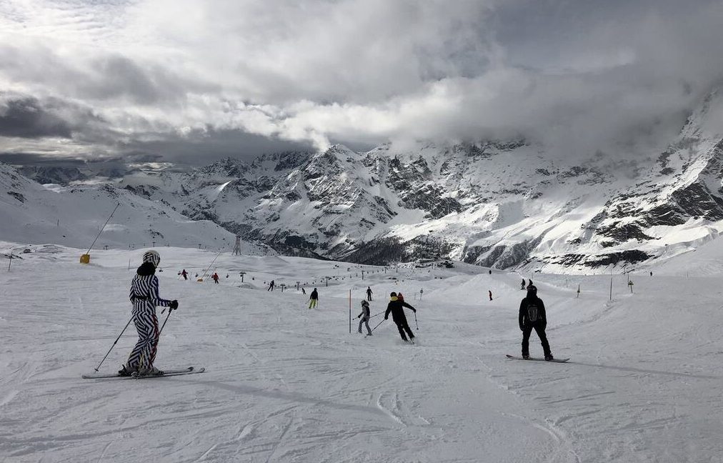
EUROPE’S BEST START TO A SKI SEASON IN MEMORY
Countering mainstream groupthink, reality is once again slapping climate alarmism square in the chops.
Recently, ski resorts from the French Alps right the way down to the Italian Dolomites have been reporting more than 3 feet of fresh powder, resulting in a historically-early start to the the European ski season.
Absurd notions that Europe’s favorite winter pastime is a thing of the past have taken a hit after temperatures across the region fell off a cliff in November, back to “a crisp 1990s sort of climate,” reports
goodnewsnetwork.org.
In many parts parts of the Alps, snow totals have actually exceeded 6 feet which has led big-name resorts in France, Switzerland, Italy, and Austria bringing their opening dates of the 2023-24 season forward by at least a week, to November 18.
Resorts such as Tignes and Val Thorens in France, Passo del Tonale, Temu, and Madonna di Campiglio in Italy, Kitzbühel in Austria, and Davos, Zermatt, and Verbier in Switzerland are all opening early–with the latter opening three weeks early.
“Storms have been piling into the Alps for the last two weeks, with snow accumulations of more than 1 meter [3.3ft] quite widespread now on the upper slopes,” said
Ian McIlrath, managing director of Ski Solutions holiday company.
“This will ensure a solid base for the winter ahead, and with a lot more snow in the forecast, it’s shaping up to be one of the best starts to the winter ski season that I can remember.”
Indeed, looking ahead, Europe is due another absolute pounding — from Scandinavia, through the Alps, to the Balkans:

GFS Total Snowfall (cm) Nov 17 – Dec 3 [
tropicaltidbits.com]
As anomalous cold sets in:

GFS 2m Temperature Anomalies (C) Nov 24 [
tropicaltidbits.com]
MAINE’S HISTORICALLY COLD FIRST HALF OF NOVEMBER
The first half of November has been one of the chilliest-ever across New England states, such as Maine.
Looking to the past 30-years of climate data, first half of November 2023 (1st – 15th) has come out as the second-coldest at 38.2F:

Another blast of polar cold is forecast to descend into the region
Thanksgiving week, as it is the majority of the Lower 48:

GFS 2m Temperature Anomalies (C) Nov 21 – Nov 27 [
tropicaltidbits.com]
All this cold air has assisted the region’s ski and snowboarding resorts, too, allowing them to open early.

GFS Total Snowfall (cm) Nov 17 – Dec 3 [
tropicaltidbits.com]
‘SNOW PTSD’ IN SAN BERNARDINO MOUNTAINS
Last season’s unprecedented snowfall hit Sierra mountain communities hard, and the forecast storms are bringing unwanted flashbacks.
San Bernardino Mountain residents are used to snow, but the magnitude of last season storms was unlike anything the region has ever seen. Eight months later, recovery is still ongoing, and worry is rife that this coming winter will bring repeat punishment.
For weeks last winter, many San Bernardino Mountains residents remained trapped in their homes without power, buried under as much as 12 feet of snow.
Some 350 residences and businesses were damaged or destroyed — including one of the area’s largest grocery stores, whose roof collapsed, and several houses that exploded because of buried gas meters.
Tragically, once the roads were finally cleared, more than a dozen people had been found to have died, many found frozen in their homes.
“I know I have PTSD for snow,” said San Bernardino local
Teri Ostlie, which is a sentiment echoed by many of her neighbors.
A hit of snowfall back in early-May triggered a daylong panic attack, said Ostlie.
“It was awful. I couldn’t trust that I was safe.”
Latest forecasts reveal this winter could deliver a repeat, and the hope is that local officials, particularly in mountainous areas, are better prepared.
“We have the lessons learned,” said San Bernardino County Supervisor
Dawn Rowe.
“You can’t be perfect on your first time experiencing the first of anything, but we’ve done a good job of trying to quantify the areas where we fell short … and making sure we have backstops in place.”
During the snowstorms, it took time for the county’s emergency operations to get running. It wasn’t until March 2 — six days after the National Weather Service issued its first-ever blizzard warning for the region — that the county’s OES began holding daily briefings to coordinate responses with different agencies, records show.
It took almost 24 hours to coordinate and establish effective communications between the various volunteer groups, according to an internal report. This caused frustration within the volunteer groups and initial ineffective management of the groups.

Highway 18 sign in the San Bernardino Mountains on March 3 [Brian van der Brug]
Another major issue was mountain roadways, many of which took weeks to reopen — and that didn’t include clearing hundreds of private roads. This affected the area’s major utilities which, without their own plows, had to ask the county to help with accessing outages — a request that county officials made a priority but that diverted key equipment from clearing operations.
The weather itself was
another issue, points out Rowe.
“This is really the first time that the county has experienced an operation that went so rapidly from a plowing operation to what they call a
‘scoop and dump’” — plows were overwhelmed by the depth and weight of the snow, rendering typical equipment ineffective, she said.
At Mountains Community Hospital in Lake Arrowhead, staff members also speak of PTSD.
Julie Davis, director of acute care nursing, said nobody could leave the hospital due to the uncleared roads.
Hospital staff slept on cots in offices, with 10 nurses on rotating shifts, while other staff maintained cleaning and food services, said Davis, who couldn’t get home to her 5-year-old son for six days.
Looking ahead to this winter, hospital staff have a plan. They will prepare to have more fuel for snow removal equipment in the event of another emergency, add cots and pillows in case they need to stay overnight and have a better line of communication with county officials.
“I know everybody has a little PTSD from the last storm. But I know that the community is going to do better this year because we’ve already been planning for the entire year,” said Davis.
Local governments and authorities, told to expect ever-warning temperatures and decreasing snowpacks, are wholly unprepared for the realities of what a slumberous sun could be about to deliver. Last winter is proof of this. It is on the people to prepare.
WHERE ARE THE SUNSPOTS?
According to NOAA, we’re nearing Solar Maximum of cycle 25, but where are the sunspots?
Today, Nov 17, the Earth-facing solar disk is all-but blank, barring two sunspot regions departing around the southeastern limb:

These two sunspots are also stable and pose no threat for strong solar flares [SDO/HMI]
This weekend could see the first ‘blank’ day since the
one-off on June 8, 2022 and before that, Dec 12, 2021.
Stay tuned for updates.
This weekend could deliver the first 'spotless day' in years...

electroverse.info


 www.zerohedge.com


")
 abcnews.go.com