doctor_fungcool
TB Fanatic
rona + tsumani's+bombstorm+shortages=s DOOM


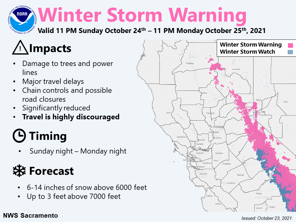

Why are you multiplying by 10. 8 ft of snow is about 10 inches of rain.
Wildfires can produce hyperphobic soils. This happens when intense heat burns plant/organic matter and produces a waxy substance that repels water, rather than absorbing it and allowing it to percolate subsurface. Following a fire, it is common to cover the soil with weed free straw to avoid erosion.
There was a lot of land burned in the west this year. Raw, exposed soil, particularly on slopes or near watercourses, will be particularly vulnerable to mud-slides.
^^^^^^^^^^^^^^
Pray for it to sag southward
Lake Oroville reservoir
View attachment 297629
Folsom Lake
View attachment 297630
Lake Shasta
View attachment 297632
^^^^^^^^^^^^^^^^^^
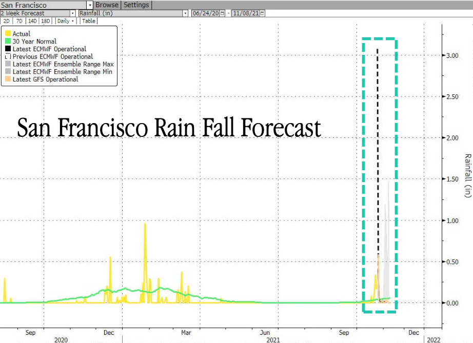
Here is long range weather prediction:
Zerohedge
ZeroHedge - On a long enough timeline, the survival rate for everyone drops to zerowww.zerohedge.com
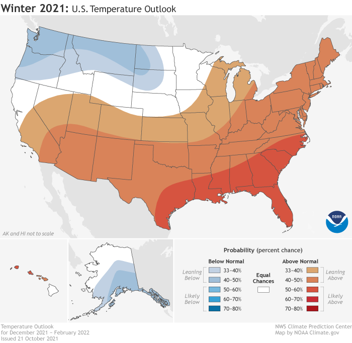
NOAA's Winter Outlook Warns Of 'Double Dip' La Nina, Expect Colder Than Normal Pacific Northwest
THURSDAY, OCT 21, 2021 - 10:30 PM
La Niña conditions are emerging for the second consecutive winter, impacting the weather across the U.S. in the coming months. The National Oceanic and Atmospheric Administration's (NOAA) Climate Prediction Center (CPC) announced Thursday its seasonal outlook for winter from December 2021 through February 2022.
NOAA's 2021 Winter Outlook outlines wetter-than-average conditions for the Northern U.S., mainly in the Pacific Northwest, northern Rockies, Great Lakes, Ohio Valley, and western Alaska. The report said widespread drought in the western half of the U.S. would continue to be monitored.
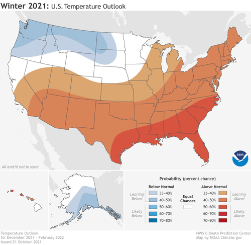
"Consistent with typical La Nina conditions during winter months, we anticipate below-normal temperatures along portions of the northern tier of the U.S. while much of the South experience above-normal temperatures," said Jon Gottschalck, chief of CPC.
NOAA's temperature outlook for the States:
The potential development for a double-dip La Niña will also influence precipitation outlooks:
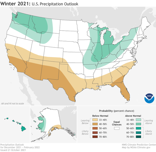
To sum up, La Niña conditions will push the jet stream further north, which leads to a drier and warmer pattern across the Deep South to Southeast. This doesn't mean those areas won't be hit with Arctic blasts, similar to what nearly collapsed Texas' power grid in February. The Lone Star State appears to be taking no chances this year and next as it warned power companies to brace for cold snaps and upgrade systems to avoid blackouts.
I always heard it was a foot-to-inch comparison. One foot of snow was one inch of rain.
Open windows. That's nice. I'd love to have the windows open. The problem I have in my neighborhood is that any nice day there is people are constantly out in the backyard at their fire pits burning. People invested a ton in their fire pits and they are going to use them. You can't have your windows open here long due to it. Your house will soon smell like a campfire.Yeah, not a great sign. Michigan's looking at the worst kind of winter: warm / wet. That's bad because then ice gets involved.
The best is warm / dry. You get the nicest weather--sometimes even warm enough to open the windows!--but without any of the hassle. Cold / dry is next; you expect cold, but there are no serious weather-related problems. Cold / wet is next, because at least then the water is snow and it can be handled. Warm / wet brings melting into the picture. Frozen ground plus unexpected melt means FLOODING.
Had a earthquake in LA about two hours ago. Maybe they could get a larger one off the coast and have them unloaded in LA....wondering what might happen to all of those container ships out there.....
15 miles SE of Portland here: raining pretty good, but no wind yet. I expect to lose power if we get 40 mph gusts.
Depends on temperature and moisture content. You can get snow ratios from 15:1 all the way down to 8:1 or so. The lower being extremely heavy and wet and the upper being fluffy and dry.
...wondering what might happen to all of those container ships out there.....
I don't see how you can avoid this type of disaster with all the ships out there. Extremely difficult to launch a Rescue effort in that environment.40 Shipping Containers Adrift Off US Pacific Coast After Vessel Hit By Rough Seas
Fire Breaks Out On Ship That Lost 40 Containers Off US Pacific Coast | ZeroHedge


Lol, I've always used the "hung like a can of tuna fish" descriptive to hide behind!!!!
When I was a young teenager, California had two years of severe drought followed by an afternoon of storms that not only flooded our nearest town, there was a picture on the news of a sign saying "Drought Control Office."
It was nearly underwater from the flooding...
While this time things are much more extreme, the patterns of severe drought, forest fires followed by massive flooding are pretty typical of the California Weather cycle.
During that same flooding, that drowned the drought sign, our neighbors showed up at our house on horseback herding about 25 horses. They had gotten home from shopping just in time for the mountainsides of our valley to come crashing down on the stables, they just got the horses out as the mud smashed into them and herded the horses into our yard which had chain link fences.
The school was canceled for several days because the roads were closed, and houses up and down the coast fell into the sea.
This year, the fires were worse and the floods are coming sooner but otherwise, the pattern is the same.
www.zerohedge.com


 Five inches of rain in 24 hours in dowtown Portland would screw me over bigly.
www.zerohedge.com
Five inches of rain in 24 hours in dowtown Portland would screw me over bigly.
www.zerohedge.com

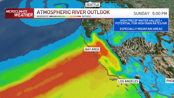
I am on the eastern side of that yellow/orange blob. It has been raining steadily all afternoon and evening. The rain was like popcorn on a hot skillet - jumping up as it hit hard. Wind is down. from earlier (20-30 mph.) Sounds like someone left the shower on. We are supposed to get 2 more inches tonight.here is a radar map imagine from today 10/24/21 at 19:28
It's unusually compact storm.
I should add the storm is centered (E-W) on San Francisco/Oakland areas
View attachment 298161
I am on the eastern side of that yellow/orange blob. It has been raining steadily all afternoon and evening. The rain was like popcorn on a hot skillet - jumping up as it hit hard. Wind is down. from earlier (20-30 mph.) Sounds like someone left the shower on. We are supposed to get 2 more inches tonight.
There is some local street flooding and people are out clearing street gutters and grates. Luckily, the leaves have just begun to turn and drop a bit here or we woud be in big trouble.
It is supposed to drop to showers tomorrow with an occasional thunderstorm. It's all gone here by Monday night - then sunny for a week.
WOW. Downtown Sacramento is expected to get FIVE INCHES OF RAIN in one 24 hour period.
About 1971/72 ish, I graduated from Highschool in 1973 and my family moved to Mississippi - by 1977 I was traveling with friends during the school break in Southern California and the drought pattern was back. You had to ask for water if you were eating out and there were other restrictions.Mid-Late 1970's?