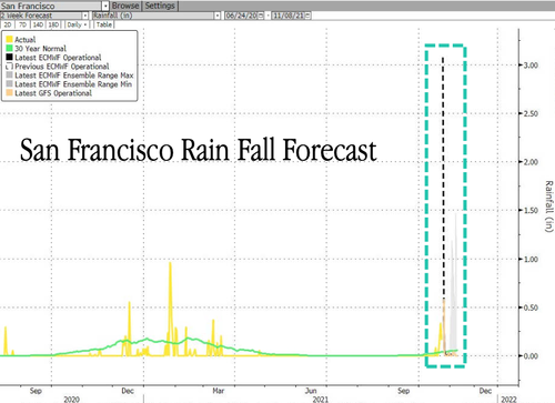
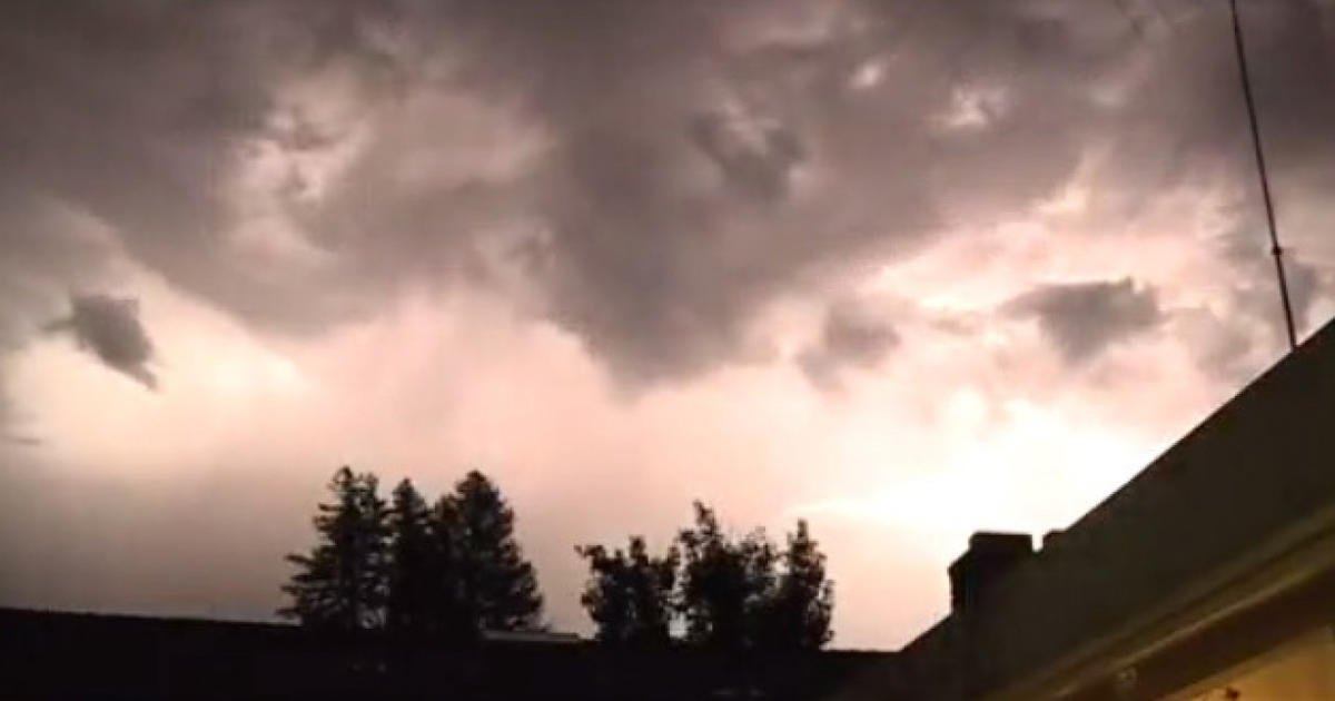
ALERT 8 feet of snow. 48 foot waves. A Bomb Cyclone To Hit PNW and Canada Coastline

Status
Not open for further replies.

doctor_fungcool

TB Fanatic
Back-to-back bomb cyclones are forecasted to bring extreme weather across the country impacting up to 50 million people add to that the possibility of a tsumsmi from the Canary Islands which could affect 65 million folks ....

makes a person feel DOOMISH
 
Last edited:

Melodi

Disaster Cat
When I was a young teenager, California had two years of severe drought followed by an afternoon of storms that not only flooded our nearest town, there was a picture on the news of a sign saying "Drought Control Office."

It was nearly underwater from the flooding...

While this time things are much more extreme, the patterns of severe drought, forest fires followed by massive flooding are pretty typical of the California Weather cycle.

During that same flooding, that drowned the drought sign, our neighbors showed up at our house on horseback herding about 25 horses. They had gotten home from shopping just in time for the mountainsides of our valley to come crashing down on the stables, they just got the horses out as the mud smashed into them and herded the horses into our yard which had chain link fences.

The school was canceled for several days because the roads were closed, and houses up and down the coast fell into the sea.

This year, the fires were worse and the floods are coming sooner but otherwise, the pattern is the same.
 

Doomer Doug

TB Fanatic
San Franciso and California are getting much more rain than that, plus the debris slides and the fact the same storm extends from Alaska to San Francisco.
Portland may be only getting 25 mph winds, but the coast is looking at 100 mph plus.
 

doctor_fungcool

TB Fanatic
Major Flood Threat:’ National Weather Service Says Storm Could Be Historic
By Madisen KeavyOctober 23, 2021 at 5:53 pm
Filed Under:NorCal Storm, Storm Watch


SACRAMENTO (CBS13) – We’ve talked about the rain moving into the area over the last week with the potential for flash floods and mudslides being underscored. Don’t take the dry skies and calm trees as a sign of what’s to come. In just a few hours it’s projected we’ll see historic amounts of rain, which could lead to those dangerous weather situations.
Top Videos


Saturday Evening Forecast‑ 10/24/21


Saturday Evening Forecast - 10/24/21

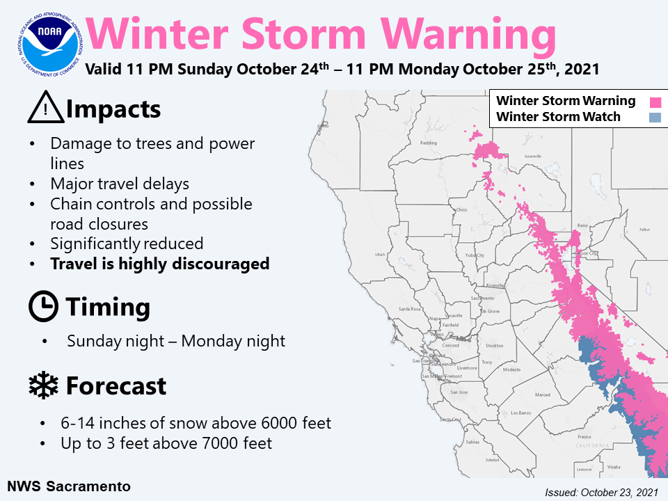
winter-storm-warning-national-weather-service.png

Sacramento calls this a major system and it’s something we don’t see very often in October, or really in any season, fall or not.
READ MORE:Updates: Major Storm System Arrives In Sacramento Area
For the latest on the storm, visit our storm updates page.


The amount of rain projected for downtown Sacramento by the National Weather Service is 4.86 inches in a 24-hour period. That would be the second-highest rainfall 24-hour total on record.
If projections become a reality, this storm would be historic—comparable to similar storms in 2009 and 1880.
However, at higher elevations, we will see even more rain.
Blue Canyon is a marker for the National Weather Service along Highway 80.
READ MORE:Ironman California 2021 Triathlon Canceled Due To Safety Concerns Brought On By Powerful Storm
They are forecasting a 24-hour rainfall total of 8.2 inches. That would make the fifth wettest 24-hour total ever on record for Blue Canyon and any area in the mountains if the forecast holds.
The storm could also make history because of its magnitude and that it’s happening so close to the recent fires. Burn scares this fresh combined with a storm of this size have officials on watch.
Craig Shoemaker, a meteorologist at the National Weather Service in Sacramento, said, “It’s just the matter that it’s coming so fast and over such a short period of time, and especially over those burn scars. And again, there’s going to be a major flood threat also in Sacramento and over the valley. We don’t want to downplay that at all. We’re talking about one of the highest rainfall totals, potentially that we’re currently forecasting over 24 hours period for Sacramento.”
Shoemaker’s words are another warning that this mild weather won’t last. In a few hours, we’ll see this weather system change things.
It’s important to have a way to get emergency alerts and stay vigilant in areas impacted by the fires.
MORE NEWS:Will There Be Major Flooding In Sacramento? What You Can Expect From Sunday’s Storm
The National Weather Service projects that rain will move in fast and that there will be a lot of it.


https://www.fool.com/mms/mark/ai-ce...rce=esatabwdg0211156&wsource=esatabwdg0211156

CBS Sacramento


mw
tpid=5b0a7de7-9db9-43bc-8766-4da02b95600e-tuct7008fdd
 

Blacknarwhal

Let's Go Brandon!
Wildfires can produce hyperphobic soils. This happens when intense heat burns plant/organic matter and produces a waxy substance that repels water, rather than absorbing it and allowing it to percolate subsurface. Following a fire, it is common to cover the soil with weed free straw to avoid erosion.

There was a lot of land burned in the west this year. Raw, exposed soil, particularly on slopes or near watercourses, will be particularly vulnerable to mud-slides.
^^^^^^^^^^^^^^
Pray for it to sag southward

Lake Oroville reservoir
View attachment 297629

Folsom Lake
View attachment 297630

Lake Shasta
View attachment 297632
^^^^^^^^^^^^^^^^^^
Here is long range weather prediction:


NOAA's Winter Outlook Warns Of 'Double Dip' La Nina, Expect Colder Than Normal Pacific Northwest

THURSDAY, OCT 21, 2021 - 10:30 PM

La Niña conditions are emerging for the second consecutive winter, impacting the weather across the U.S. in the coming months. The National Oceanic and Atmospheric Administration's (NOAA) Climate Prediction Center (CPC) announced Thursday its seasonal outlook for winter from December 2021 through February 2022.

NOAA's 2021 Winter Outlook outlines wetter-than-average conditions for the Northern U.S., mainly in the Pacific Northwest, northern Rockies, Great Lakes, Ohio Valley, and western Alaska. The report said widespread drought in the western half of the U.S. would continue to be monitored.

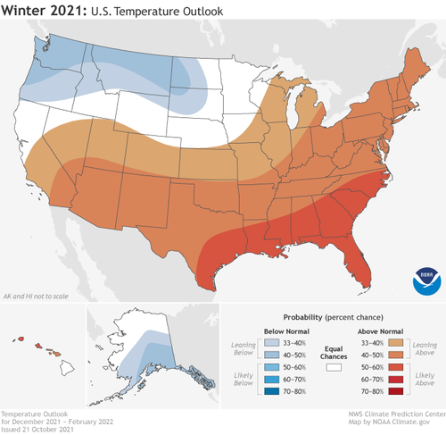
"Consistent with typical La Nina conditions during winter months, we anticipate below-normal temperatures along portions of the northern tier of the U.S. while much of the South experience above-normal temperatures," said Jon Gottschalck, chief of CPC.

NOAA's temperature outlook for the States:


The potential development for a double-dip La Niña will also influence precipitation outlooks:
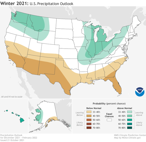


To sum up, La Niña conditions will push the jet stream further north, which leads to a drier and warmer pattern across the Deep South to Southeast. This doesn't mean those areas won't be hit with Arctic blasts, similar to what nearly collapsed Texas' power grid in February. The Lone Star State appears to be taking no chances this year and next as it warned power companies to brace for cold snaps and upgrade systems to avoid blackouts.

Yeah, not a great sign. Michigan's looking at the worst kind of winter: warm / wet. That's bad because then ice gets involved.

The best is warm / dry. You get the nicest weather--sometimes even warm enough to open the windows!--but without any of the hassle. Cold / dry is next; you expect cold, but there are no serious weather-related problems. Cold / wet is next, because at least then the water is snow and it can be handled. Warm / wet brings melting into the picture. Frozen ground plus unexpected melt means FLOODING.
 

Hfcomms

EN66iq
I always heard it was a foot-to-inch comparison. One foot of snow was one inch of rain.

Depends on temperature and moisture content. You can get snow ratios from 15:1 all the way down to 8:1 or so. The lower being extremely heavy and wet and the upper being fluffy and dry.
 

TKO

Veteran Member
Yeah, not a great sign. Michigan's looking at the worst kind of winter: warm / wet. That's bad because then ice gets involved.

The best is warm / dry. You get the nicest weather--sometimes even warm enough to open the windows!--but without any of the hassle. Cold / dry is next; you expect cold, but there are no serious weather-related problems. Cold / wet is next, because at least then the water is snow and it can be handled. Warm / wet brings melting into the picture. Frozen ground plus unexpected melt means FLOODING.
Open windows. That's nice. I'd love to have the windows open. The problem I have in my neighborhood is that any nice day there is people are constantly out in the backyard at their fire pits burning. People invested a ton in their fire pits and they are going to use them. You can't have your windows open here long due to it. Your house will soon smell like a campfire.
 

DennisD

Veteran Member
15 miles SE of Portland here: raining pretty good, but no wind yet. I expect to lose power if we get 40 mph gusts.
 

SageRock

Veteran Member
Depends on temperature and moisture content. You can get snow ratios from 15:1 all the way down to 8:1 or so. The lower being extremely heavy and wet and the upper being fluffy and dry.

The Sierra Nevada mountains in California are famous for heavy, wet snow known as "Sierra cement."
 

SageRock

Veteran Member
In Northern Nevada, about 240 miles inland, it's nearly constant rain, heavy rain, and drizzle with moderate wind so far. There are flash flood warnings up from the weather service. Looks like we're in for a wet winter!
 

Bubble Head

Has No Life - Lives on TB
40 Shipping Containers Adrift Off US Pacific Coast After Vessel Hit By Rough Seas
Fire Breaks Out On Ship That Lost 40 Containers Off US Pacific Coast | ZeroHedge
I don't see how you can avoid this type of disaster with all the ships out there. Extremely difficult to launch a Rescue effort in that environment.
Plan on hearing more about lost containers and ships possibly running into each other. 48 foot swells driven by 100 mile winds is nothing to take lightly. Lives will be lost.
 
October 23, 2021
The Storm's Future is Now Known

The models have converged to a consistent solution, the storm is beginning to "bomb", and I can now provide a forecast with some confidence.
This will be the strongest Northwest storm on record, but its strength will collapse as it approaches the coast of Vancouver Island. More quickly than any storm in my experience.
And there will be strong winds over land, but not from the south, but from the east, as air is pulled westward by the immense, powerful storm offshore.
Let me begin by showing you the latest water vapor satellite image over the eastern Pacific (below), with the dark areas indicating dry conditions.
This is a very potent storm, with massive clouds and extreme darkening, which indicates strong sinking behind the low center (you can see the moisture curling up). Such sinking is a sign of vigor.

Both the American (GFS) and European Center (ECMWF) models indicate very rapid intensification over the next 24h, with the storm catching down to around 943 hPa (see below for 8 AM Sunday). This is a "bomb" cyclone, with the pressure dropping more than 24 hPa in 24 hours.


There has never been a storm this strong in the nearshore waters of our region.

The closest was 950 hPA in 1981.
Both U.S. and European modeling systems predict massive swell/waves approaching the West Coast from this monster storm, reaching 30 feet on Sunday evening!

Both modeling systems indicated that the storm will very rapidly weaken on Monday, making landfall on Vancouver Island with a central pressure around 985 hPa (see US model forecast below) at 11 PM Monday.

I don't think I have seen so rapid a collapse of a storm over water.

But what will happen overland? Will there be some strong winds?

The answer is yes.

Let me show you. The three stages to this unusual event.

Stage 1: An intense low offshore and a large east-west pressure difference over the region

At 8 AM Sunday a huge, deep low center will be due west of the Columbia River outfall. The lines on the map are isobars, lines of constant sea level pressure. A very large pressure difference is over us, with lowered pressure to the west. In the presence of terrain, such a pressure gradient will produce very large easterly (from the east) winds in terrain gaps, and strong winds offshore.


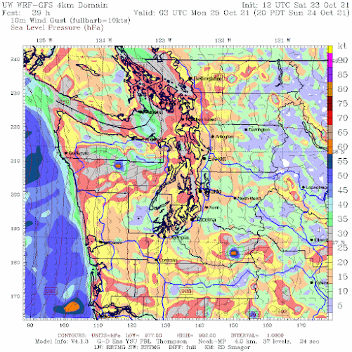
Below are the predicted wind gusts at 11 AM on Sunday (in knots). Strong easterly gusts (to roughly 55 knots) in the eastern Strait of Juan de Fuca as the air in the Strait accelerates to the west, and winds will accelerate down the western slopes of the Cascades, with powerful gusts from Enumclaw to North Bend. Strong southeasterly winds offshore.

Stage 2. A Still Powerful Storm Moves Towards Land

Here is the sea-level pressure forecast at 8 PM Sunday. Just wow. An absolutely intense pressure difference over the coastal waters of Oregon and Washington. Very strong winds.


The predicted wind gusts at this time will be substantial along the coast, some reaching 60 knots (roughly 70 mph). Strong winds over the volcanic peaks and over portions of NW Washington.

Stage 3: The Weakened Low Moves North of western Washington

With the (weakened) low center northwest of western WA, there will be a substantial north-south pressure difference over Puget Sound and the Strait of Georgia (1 AM Tuesday is shown). That means WIND.


Winds will be strong, southerly, and gusty over the inland waters of Puget Sound, with gusts accelerating to 30-40 mph, especially near the water.

And don't forget the precipitation. California getting hit hard, with up to 8-10 inches through Tuesday morning (see forecast below). And there is going to be significant snow in the North Cascades and British Columbia this week.


Time to stop.....enough weather for a day!

My Podcast Has More Background Information on the Big Storms of the Northwest:
 

Doomer Doug

TB Fanatic
I walked back to my apartment and the storm hit around 1o' clock. Got hit with a micro burst that soaked me good the last block or so.

The storm was forecast to hit at 11 am. So it was 2 hours late.
It was worth it to see all the golden leaves swirling towards the ground. :eleph:
Reminded me of that scene in Crouching Tiger hidden Dragon? where they fought flying around the forest with all the leaves.

Took some cell phone pics. A real mystical experience. All leaves will be on the ground by Tuesday.
Nice and comfy in my apartment for today at least.
 

marsh

On TB every waking moment
South of Sacramento it is just a good wet storm with some wind. The last one we had pushed over my obelisk that supports my jasmine vines, so I secured it with wire at compass points. All the tellises and arches are secured, all the outside furniture covered, so I can just sit inside all cozy and watch the rain puddle in the fallen leaves on the patio. It's a nice feeling.
 

Double_A

TB Fanatic
When I was a young teenager, California had two years of severe drought followed by an afternoon of storms that not only flooded our nearest town, there was a picture on the news of a sign saying "Drought Control Office."

It was nearly underwater from the flooding...

While this time things are much more extreme, the patterns of severe drought, forest fires followed by massive flooding are pretty typical of the California Weather cycle.

During that same flooding, that drowned the drought sign, our neighbors showed up at our house on horseback herding about 25 horses. They had gotten home from shopping just in time for the mountainsides of our valley to come crashing down on the stables, they just got the horses out as the mud smashed into them and herded the horses into our yard which had chain link fences.

The school was canceled for several days because the roads were closed, and houses up and down the coast fell into the sea.

This year, the fires were worse and the floods are coming sooner but otherwise, the pattern is the same.
Mid-Late 1970's?
 

marsh

On TB every waking moment

Northern California Swamped With "Historic Rain" Amid Rare Atmospheric River Event

SUNDAY, OCT 24, 2021 - 08:00 PM

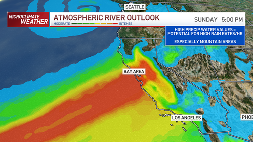
The National Weather Service's (NWS) Sacramento office said "potentially historic rain" rain has fallen in parts of Northern California after a bomb cyclone accompanied an atmospheric river that unleashed massive amounts of moisture pulled in from the Pacific Ocean.


Northern California bore the brunt late Saturday/Sunday, with record rainfall in some areas. NWS Bay Area said, "We just passed the Gold Rush year of 1849 for 7th wettest October on record for Downtown SF. 1876 (3.36) here we come..(Current value is 3.14 which ties 1849)."

Evacuations were ordered for parts of Northern California that have been drought-stricken and left barren by wildfires. Areas that have been burnt are prone to dangerous flooding called "debris flows."

View: https://twitter.com/i/status/1452374182289809409
.54 min

1635124164332.png
1635124210908.png

1635124259906.png

"If you are in the vicinity of a recent burn scar and haven't already, prepare now for likely debris flows," the Sacramento weather service tweeted. "If you are told to evacuate by local officials, or you feel threatened, do not hesitate to do so. If it is too late to evacuate, get to higher ground."

View: https://twitter.com/i/status/1452311434860318726
.25 min

Flooded streets were reported across the Bay Area, closing some in Berkeley and Oakland's Bay Bridge toll plaza. Just north of San Francisco, a whopping 6 inches of rain has fallen this weekend. Rainfall estimates for the Bay Area show at least 3 inches have fallen, trouncing any other storm in years.


"Some of our higher elevation locations could see 6, 7, 8 inches of rain before we're all said and done," Sean Miller, a meteorologist for the NWS in Monterey.

The convergence of storms brings Northern California a huge relief amid devastating droughts and wildfires this past summer.

As we've previously mentioned, La Niña conditions have been declared by NWS, which means wetter than average conditions for Northern California and the Pacific Northwest. In contrast, drier than average conditions are expected for Southern and Central California.
 

nebb

Veteran Member
so far a nothingburger here....SW wa.....about 45 miles north....15 miles east of Portland
 

Pinecone

Has No Life - Lives on TB
Here in the South/Central Willamette valley its a dud. Little rain, almost no wind except for a rare gust here and there. Just enough to send the leaves cascading in a leaf storm. Of course, as I wrote that the lights sorta blinked for no reason. lol
 

Double_A

TB Fanatic
here is a radar map imagine from today 10/24/21 at 19:28

It's unusually compact storm.

I should add the storm is centered (E-W) on San Francisco/Oakland areas
WUNIDS_map-1.gif
 

Doomer Doug

TB Fanatic

WOW. Downtown Sacramento is expected to get FIVE INCHES OF RAIN in one 24 hour period.

Not much of a bang in downtown Portland, after my microburst around 1pm. For whatever reason it looks to be aimed directly at Central and Northern California. I also heard British Columbia got hammered. Much of the coastline from Alaska to San Francisco got those 100 mph winds, and 48 foot swells people were poo pooing.

Lots of flooding and debri slides also.
 

Doomer Doug

TB Fanatic
I'm sure glad it headed south into California and not straight at moi in downtown Portland. :hof:Five inches of rain in 24 hours in dowtown Portland would screw me over bigly.


Northern California Swamped With "Historic Rain" Amid Rare Atmospheric River Event
Tyler Durden's Photo

BY TYLER DURDEN
SUNDAY, OCT 24, 2021 - 08:00 PM
The National Weather Service's (NWS) Sacramento office said "potentially historic rain" rain has fallen in parts of Northern California after a bomb cyclone accompanied an atmospheric river that unleashed massive amounts of moisture pulled in from the Pacific Ocean.

Northern California bore the brunt late Saturday/Sunday, with record rainfall in some areas. NWS Bay Area said, "We just passed the Gold Rush year of 1849 for 7th wettest October on record for Downtown SF. 1876 (3.36) here we come..(Current value is 3.14 which ties 1849)."

Evacuations were ordered for parts of Northern California that have been drought-stricken and left barren by wildfires. Areas that have been burnt are prone to dangerous flooding called "debris flows."
 

parocan

Veteran Member
The ship on fire is visible from the beaches on the west side of the southern tip of Vancouver island.
Hopefully they get the containers before they wash up on the beaches. The worst of the storm is still
working it's way in.
 

marsh

On TB every waking moment
here is a radar map imagine from today 10/24/21 at 19:28

It's unusually compact storm.

I should add the storm is centered (E-W) on San Francisco/Oakland areas
View attachment 298161
I am on the eastern side of that yellow/orange blob. It has been raining steadily all afternoon and evening. The rain was like popcorn on a hot skillet - jumping up as it hit hard. Wind is down. from earlier (20-30 mph.) Sounds like someone left the shower on. We are supposed to get 2 more inches tonight.

There is some local street flooding and people are out clearing street gutters and grates. Luckily, the leaves have just begun to turn and drop a bit here or we woud be in big trouble.

It is supposed to drop to showers tomorrow with an occasional thunderstorm. It's all gone here by Monday night - then sunny for a week.
 

Double_A

TB Fanatic
I am on the eastern side of that yellow/orange blob. It has been raining steadily all afternoon and evening. The rain was like popcorn on a hot skillet - jumping up as it hit hard. Wind is down. from earlier (20-30 mph.) Sounds like someone left the shower on. We are supposed to get 2 more inches tonight.

There is some local street flooding and people are out clearing street gutters and grates. Luckily, the leaves have just begun to turn and drop a bit here or we woud be in big trouble.

It is supposed to drop to showers tomorrow with an occasional thunderstorm. It's all gone here by Monday night - then sunny for a week.

I'm in the South Bay a few miles from SJ Airport. For today my cumulative total as of 8:30pm was only 1.1" of rain.
 

bassaholic

Veteran Member
WOW. Downtown Sacramento is expected to get FIVE INCHES OF RAIN in one 24 hour period.

I'm not too far away here in the Central Valley. We have had non stop heavy pouring rain for around 5-6 hours now. Yep, non stop.

My yard is flooded. Streets here are flooded. My rain gutters are dumping over the sides as there is just so much water and I just cleaned em all out a couple days ago knowing rain was coming.

It doesn't seem to want to let up and I need to take out the trash cans for tomorrow!

I can't remember seeing this much rain for this long.

We need rain badly but damn!
 

bassaholic

Veteran Member
Before the rain came we had pretty high winds. I would guess gusts up to 40-50 MPH. Lots of broke tree branches over here.

Nothing major though, in my yard anyways. I have about an acre and surrounded by some huge trees.
 

Melodi

Disaster Cat
Mid-Late 1970's?
About 1971/72 ish, I graduated from Highschool in 1973 and my family moved to Mississippi - by 1977 I was traveling with friends during the school break in Southern California and the drought pattern was back. You had to ask for water if you were eating out and there were other restrictions.

When I moved to the Bay Area in 1989 there was drought until around 1992 (ish) a friend in his early 20s was so used to no rain that he set up his fancy camp at Harbin Hot Springs for a festival, when hiking and was shocked to come back to find me grabbing his stuff and trying to cover it as rained poured everywhere.

In his entire "adult" life from about 17 to 22, it had never rained in the Summer...

Finally, this rain pattern is very early, around 2000 (ish) I went back for New Year in Berkeley and we left just after the midnight waltz to return to San Francisco. By 1 am the heavens had opened and the rain cascaded into flash floods that totally destroyed a friend's place of business and probably flooded some of the same places that flooded last night (like the Oakland Bridge toll bridge booths.

More often, the fires, like the 1992 Oakland Hills Fire Storm (that we raced away from while shopping right below the hills) happen in October and the serious rains come in January or February.

This year, the fires were all Summer and the rains are coming in October, and that is the same basic pattern but different timing.
 
Status
Not open for further replies.
Top