ALERT 8 feet of snow. 48 foot waves. A Bomb Cyclone To Hit PNW and Canada Coastline

Status
Not open for further replies.

marsh

On TB every waking moment

A 'monster' coming this weekend: Bomb cyclone, atmospheric river to blast western US
Doyle Rice
USA TODAY
The storms could lead to flash floods and dangerous debris flows in a wide swath of the region already devastated by recent wildfires.
  • Some of California’s most important reservoirs are at or near historic lows heading into the rainy season.
  • This weekend's atmospheric river could be a rare Category 5 event.
A series of potent storms is poised to deliver torrents of rain and feet of snow across the West over the next few days, including one on Sunday that's being called a "bomb cyclone" because of its ferocity.

Supercharged by a classic atmospheric river pattern, the storms could lead to flash floods and dangerous debris flows in a wide swath of the region already devastated by wildfires, CNN said.

Still, despite the danger, the rain and snow will be welcome across drought-plagued areas of the West. As of Thursday's U.S. Drought Monitor, nearly 92% of the western U.S. is in some level of drought. The rain will help stop smoldering wildfires and could ease water restrictions on farmers.

California has been hit especially hard by the drought. It has had some of the hottest, driest months on record in the past year. Some of California’s most important reservoirs are at or near historic lows heading into the rainy season.

"The pattern unfolding this week to next week may be one of the biggest series of storms for the rainy season for California, but there is still potential for a couple of bigger storms over the winter," AccuWeather forecaster Paul Pastelok said.

Emily Heller, a meteorologist with the National Weather Service in Sacramento, said, "This is definitely going to be one of those ground-soaking events."

The western U.S. will see a stormy, soggy weekend, forecasters say.


What is a bomb cyclone?
Meteorologists define a bomb cyclone as a rapidly strengthening storm with central pressure that plummets by 24 millibars or more within 24 hours, AccuWeather said. The process is known as bombogenesis.

A millibar is a measure of pressure. The lower the pressure, the more powerful the storm.

The cyclone will rival, in some aspects, the intensity of strong hurricanes from the Atlantic this season. For example, the bomb cyclone could be at the intensity level of Hurricane Larry, a long-lived and intense cyclone that churned across the Atlantic in early September, according to AccuWeather.

Meteorologist Ryan Maue tweeted that "this monster hurricane-force bomb cyclone this weekend will challenge observed historical low pressure off the U.S. West Coast."

What is an atmospheric river?
Atmospheric rivers are responsible for up to 65% of the western USA's extreme rain and snow events, a 2017 study said.

"An atmospheric river marked as a category 4 or a 5 is capable of producing remarkable rainfall totals over three or more days, likely to exceed 10-15% of a typical year's precipitation in some locations," Marty Ralph, director of the Center for Western Weather and Water Extremes at UC San Diego, told CNN.


This weekend's atmospheric river could be a rare Category 5 event, he said.

Made visible by clouds, these ribbons of water vapor extend thousands of miles from the tropics to the western U.S. They provide the fuel for the massive rain and snowstorms and subsequent floods along the West Coast.

Though beneficial for water supplies, these events can wreak havoc on travel, set off deadly mudslides and cause catastrophic damage to life and property, the National Oceanic and Atmospheric Administration said.

One well-known nickname for an atmospheric river is the "Pineapple Express," which occurs when the source of the moisture is near Hawaii.

A single strong atmospheric river can transport up to 15 times the water vapor compared with the average flow of water at the mouth of the Mississippi River, according to NOAA's Earth System Research Laboratory.

Contributing: The Associated Press
 

mikeho78

Contributing Member
Reading this thread brought to mind that HAARP map that used to track areas of increased "disturbance" ranging from earthquakes and bad weather to even geopolitical disturbances. I haven't browsed the woo section to find it though. It was always fun to check in on it from time to time. Does anyone else remember it? Is the HAARP program still a thing anymore?
 

Freeholder

This too shall pass.
I could not believe my eyes when I saw this. 942 hPa central pressure. Never has a storm with such low pressure moved this far south to the waters immediately offshore of the Pacific Northwest. Not even the 1962 Columbus Day Storm (which was only 955 hPa) .

I remember the 1962 storm. Power pole with transformer and lines fell and blocked the road in front of the family car. Complete with fireworks, spark arcs, and explosions.

If this storm is worse - God Help Us, Everyone.

I remember the 1962 storm, too, and I was only five years old! It took my great-grandfather's old barn down.

Kathleen
 

Groucho

Has No Life - Lives on TB
Sorry to hear that a nasty storm will strike, but I really wish the drama queens at the weather bureau would knock off the "bomb cyclone" B.S. Find another way to sell E.D. meds and laxatives.


Origin of the Term “Bomb Cyclone”
patriot
January 4, 2018
bomb cyclone, Uncategorized, winter hurricane
The term “bomb cyclone” is not listed in AFH 11-203V1 or V2, “Weather for Aircrews,” a three-week course taught to all military aviators in the United States Air Force. The volumes comprise 234 and 85 pages, for a total of 319 pages of detailed meteorology. It includes tons of references to cyclone, cyclones, and cyclonic activity, but not a word about “bomb cyclone” or “cyclone bomb,” “cyclonic bomb,” “bombogenesis,” or other variations.

So I checked an exhaustive online weather glossary. Zero. Zip. Nada.

And then I found the origin: “John Gyakum, along with the revered late Massachusetts Institute of Technology meteorologist Fred Sanders, first coined the term in a paper they published in 1980. They used the phrase to describe powerful cyclones that get their energy from rapid drops in pressure caused by hot and cold temperatures colliding.”
Here’s the link to the American Meteorological Society’s Abstract for the paper, and here’s the link to the paper itself. And here’s the citation:
Gyakum, J. R. and Sanders, F. (1980). Synoptic-dynamic climatology of the “Bomb.” Department of Meteorology, Massachusetts Institution of Technology. Retrieved from: Synoptic-Dynamic Climatology of the “Bomb”

This term, however, while coined by two researchers from MIT, was never widely adopted in the annals of mainstream meteorology. Furthermore, Gyakum stopped using it shortly after 9/11 for obvious reasons. Sanders passed away in 2006.


As of January 4, 2018, the term “bomb cyclone” has swept through the corridors of mudstream media like wildfire, even though it was never officially adopted as a weather term. Technically, it’s still just a cyclone (tropical depression), although it appears as if NOAA is caiming it has developed hurricane-force winds near its center.

Even so, tons of publications ranging from Time to Forbes, Popular Science, Fortune, and more have all put out articles about its origins. Fortune gets it right: “Technically, the term bomb cyclone comes from the scientific term “bombogenesis,” which is a storm that drops 24 millibars of pressure over 24 hours.” Well, it sort of gets it right, as the term “bombogenesis” never appeared in the original paper.

There’s a difference between normal cyclonic development and a bomb, best explained by this quote from NBC News’ Science: “Hurricane Sandy was a monster, but not a bomb since it was forecast with extraordinary accuracy a week ahead. A meteorological bomb, on the other hand, develops at a frightening pace — with the atmospheric pressure dropping a millibar or more per hour for at least 24 hours.” – NBC News

The problem with this is that the term was never used by mainstream meteorologists and just randomly popped up even though it’s surviving creator said he’s not using it any more.

Thus, I think some idiot from mudstream media re-coined it without knowing its origin, and only after it gained traction did the many outlets of mudstream media try to legitimize it by tying it back to an obscure research paper from 1980. I found a few references to various forms of it used by local meteorologists over the years, dating back to 2007.
 

Ogre

Veteran Member
How about somebody posting an official NWS forecast regarding this potential storm?
I checked the NWS forecasts for Seattle and Portland. Just rain and wind, but no special statements. Redding California has a flood watch.
You can just plug in whatever location you want.
 

Chicken Mama

Veteran Member
This really doesn't sound extreme.

"A general 1-3 inches of rain with locally higher amounts will fall on portions of Northern California and southern Oregon into Thursday night," Rayno said.
 

SpokaneMan

Veteran Member
My small town is projected to receive about 6.6 inches of rain between now and Tuesday. I have been getting Accuweather alerts on my phone telling me of flooding and landslides are probable. And I'm not worried about a thing really. I just keep thinking of all that Placer Gold that will be turned up for a lucrative spring and summer next year. In fact I was talking to a guy yesterday that goes to a place near me by the name of Yankee Jim's. (Section of the American River). Anyway he told me he was pulling about an ounce of gold per day and acquired about 3 pounds in total just this year. He then opened up a prospecting supply store in Colfax. But then again I live across the road from a gold producing creek. This is the hobby I plan to pick back up to beat inflation.
 

TKO

Veteran Member
Hopefully, the forecasters are like the forecasters we have in the midwest...can't predict their arse from a hole in the ground. If it's predicted to rain here, you can bet it won't. If they say "90% chance of rain" it won't rain. If they say, "0% chance of rain"...you best get your mowing done if you see a gray cloud in the sky.
 

Tundra Gypsy

Veteran Member
Those of us who aren't pleased with all the people moving here the last two years, are hoping we have a really, really bad winter....lots of snow and then more snow....hopefully that will send some back to where they came from; the price of real estate goes back down, and we get rid of some liberals.
 

Doomer Doug

TB Fanatic
They just issued a "wind advisory" from Sunday 0800 to Monday 0500, that being 8 am Sunday, to 5 am Monday, some 22 hours or so.

South Winds 15 to 20 mph with gusts up to 40 mph expected.

It covers the Greater Portland Area and the Lower Columbia area, including the I-5 Corridor in Cowlitz County. Also both the Southern and Central Willamette Valley.

It will mean lots of trees down, since the ground is soggy. And believe it or not, 20 mph is more than enough to take down a tree and/or power pole in the burbs.

Living downtown as I do, with underground utilities I am likely to not lose power. Water is everywhere downtown and I fully expect the additional 3 to 5 inches we will get by Monday to cause urban flooding mucho bigly.

You can add into that 1 to 3 to 3 inches of heavy rain. Saturday also will have a storm that adds another 1 or 2 of rain. It has been raining off and on all day today, plus another 1 or so on Thursday, plus today. Easily had 2 or 3 inches Thursday and Friday, with still more rain inbound Saturday.

All the leaves on the trees will be blown down onto the ground/street. All the leaves will then clog ALL the storm drains, which will create a 10 foot long, 2 or 3 feet wide, puddle of water on every single storm drain all over the city of Portland. Yep, it will make walking a bitch, and make cars have to drive through mini lakes.

Like I said, it is just the way things are in Portland. Other places get other issues, but in the fall we get Lake Erie uber alles.
 

Double_A

TB Fanatic
What general area of NW are you?

SF Bay Area will will get the southernmost portion of this storm brush by. NOAA is still advising Flood Watch for this far south specifically the North SF Bay areas and Coastal Santa Cruz Mtns, 15miles west of me. A recent fire was still burning. This should put them out, but the runoff in the Mtns is gonna be horrible in the Fire zones. About 20 yrs ago there was a mudslide in the Mountains where it buried 19 people alive, the site is a permanent tomb.
 

Mtsilverback

Veteran Member
Imagine a pineapple express coming through dropping a couple feet of snow in the valleys. Snow that is very wet! Roof collapsing heavy snow. Street snowed shut for weeks.

Ah, the memories.

EDIT! This happened a few years ago.
 
Last edited:

summerthyme

Administrator
_______________
They just issued a "wind advisory" from Sunday 0800 to Monday 0500, that being 8 am Sunday, to 5 am Monday, some 22 hours or so.

South Winds 15 to 20 mph with gusts up to 40 mph expected.

It covers the Greater Portland Area and the Lower Columbia area, including the I-5 Corridor in Cowlitz County. Also both the Southern and Central Willamette Valley.

It will mean lots of trees down, since the ground is soggy. And believe it or not, 20 mph is more than enough to take down a tree and/or power pole in the burbs.

Living downtown as I do, with underground utilities I am likely to not lose power. Water is everywhere downtown and I fully expect the additional 3 to 5 inches we will get by Monday to cause urban flooding mucho bigly.

You can add into that 1 to 3 to 3 inches of heavy rain. Saturday also will have a storm that adds another 1 or 2 of rain. It has been raining off and on all day today, plus another 1 or so on Thursday, plus today. Easily had 2 or 3 inches Thursday and Friday, with still more rain inbound Saturday.

All the leaves on the trees will be blown down onto the ground/street. All the leaves will then clog ALL the storm drains, which will create a 10 foot long, 2 or 3 feet wide, puddle of water on every single storm drain all over the city of Portland. Yep, it will make walking a bitch, and make cars have to drive through mini lakes.

Like I said, it is just the way things are in Portland. Other places get other issues, but in the fall we get Lake Erie uber alles.
Well, it should dampen the protesters fervor!

Summerthyme
 

Doomer Doug

TB Fanatic
Not really. They are one hard core, march everywhere, in any weather. I remember last Valentines Day, when we had the snow storm, bitterly cold temperatures they were rioting two blocks away from my building. The whore press spun it as having a snow ball fight with police, but they were really rioting.

I think they got the stand down order, or Soros cut off the money or whatever, since they haven't done much since Biden's election. Doesn't matter though, given the near total destruction of downtown they have completed.
 

marsh

On TB every waking moment
My small town is projected to receive about 6.6 inches of rain between now and Tuesday. I have been getting Accuweather alerts on my phone telling me of flooding and landslides are probable. And I'm not worried about a thing really. I just keep thinking of all that Placer Gold that will be turned up for a lucrative spring and summer next year. In fact I was talking to a guy yesterday that goes to a place near me by the name of Yankee Jim's. (Section of the American River). Anyway he told me he was pulling about an ounce of gold per day and acquired about 3 pounds in total just this year. He then opened up a prospecting supply store in Colfax. But then again I live across the road from a gold producing creek. This is the hobby I plan to pick back up to beat inflation.
We used to have a guy who would check the ribbed culverts under roads. Good haul sometimes for little effort.
 

Chapulin

Veteran Member
NOAA
PZZ898-240545-
853 AM PDT Sat Oct 23 2021

.SYNOPSIS FOR WASHINGTON AND OREGON WATERS...A cold front will move E across the inner waters and moving inland this afternoon. A stronger cold front will approach the area from the W tonight as a very intense low pressure center develops W of the region. The very intense low will track E and NE and over the outer NW portions of the waters Sun afternoon and Sun night as the front moves E and inland late Sun. The low pressure will then move slowly N of the waters Mon. A third cold front will move E into the region Mon night, then pass inland Tue. Yet another cold front will move over the waters Tue night, and pass inland Wed. High pressure will then build over the waters Tue night, and shift inland Wed. Low pressure center will move NE over the area Wed night while lifting a warm front over the region. Large NW swell will impact most of the region Sun into next week.
 

marsh

On TB every waking moment

Bomb Cyclone To Unleash Atmospheric River Over Northern California

SATURDAY, OCT 23, 2021 - 01:00 PM

A "bomb cyclone" will unleash an atmospheric river Saturday night into Sunday across Northern California.

"By Saturday night, a rapidly intensifying Pacific cyclone directing a powerful atmospheric river squarely at the West Coast delivers a fire hose of rich subtropical moisture into California," the Weather Prediction Center (WPC) said Friday.

These two simultaneous weather phenomenons will result in the season's first snow event in the Sierras and torrential rains for the coastline and valleys across central and Northern California.

"You might hear this term referencing the Sunday-Monday storm coming our way. A bomb cyclone is simply a storm that gets very strong very quickly. It drops at least 24 mb (a unit of pressure) in 24 hours. The lower the pressure, the stronger the storm," said Sacramento-based KTXL's Adam Epstein.


In Northern California, rainfall estimates through the end of the weekend are around 2-4 inches. In San Francisco, estimates are upwards of 3 inches.


WPC warns that some areas could receive 8-10 inches.

1635026610156.png

The rare level 5 atmospheric river event could be enough rain to alleviate drought-stricken areas ravaged by wildfires.
"An atmospheric river marked as a category 4 or a 5 is capable of producing remarkable rainfall totals over three or more days, likely to exceed 10% to 15% of a typical year's precipitation in some locations," said Marty Ralph, director of the Center for Western Weather and Water Extremes at the University of California San Diego.
In higher elevations, wet snow across the Sierras could amount to 1-3 feet.

View: https://twitter.com/i/status/1451703744538759170
.25 min

The news gets better for Northern California and the Pacific Northwest as WPC has declared La Niña conditions, which means wetter than average conditions will ease areas plagued by drought. As for Southern and Central California, La Niña means a drier than average winter.
 

Doomer Doug

TB Fanatic
The wind advisory starts at 11 am Sunday and ends at 5 am Monday morning with the same general area.

The winds will be from the south at 15 to 25 mph with gusts of 40 mph.

The rain will likely 1 to 3 inches.
 

West

Senior
The wind advisory starts at 11 am Sunday and ends at 5 am Monday morning with the same general area.

The winds will be from the south at 15 to 25 mph with gusts of 40 mph.

The rain will likely 1 to 3 inches.

Typical Pacific Crest and Sierra Mountain range weather.

I argue that if the forest in the PNW where much healthier, especially the ones in California that these weather patterns would develop twice as much rain from transpiration alone.

Healthy young replanted forest from proven professional forest management that uses clear cutting in small checked board sections so there is always a logging industry, also makes its own wet weather. Cause young trees now how to turn on the transpiration faucets..

Seen it in 1997 at the peak and end of the N. CA. logging, milling and associated industry we once had.

The spotted owl, red legged tree frog ,wild mnt flowers, all killed the industry. And all three where benefiting from healthy forest and logging..
 

marsh

On TB every waking moment
Just buttoned up the backyard for the storm. I was gifted 2 bales of straw for winter mulch and now it is all safely tucked under tarps for the interim. The strom gusts of wind don't bother me. Being on the Delta, we get them all year.

My favorite weather site for CA trends.


Strong atmospheric river to bring fire season-ending and drought-mitigating heavy rain to NorCal, but also high risk of burn area flooding/debris flows

Water! Falling from the sky!
1635043306434.png

In Northern California, it has been a good old rainy week. Many spots have seen a couple inches or more; nearly everywhere has seen at least enough for some modest puddles. In some areas, the amount of rain that has already fallen is probably enough to greatly attenuate or end fire season. This recent precipitation means that autumn 2021 is already progressing quite differently than recent bone-dry autumns–and this is a most welcomed change for most folks who have endured seemingly unending fire seasons in recent years. It’s also reassuring, in the midst of what was recently measured as California’s most intense drought on record by some metrics, to see water falling from the sky…with a high confidence forecast of more on the way.

Very strong, warm atmospheric river to affect California on Sunday

1635043508165.png
1635043610648.png


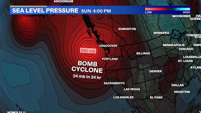
I’ll cut right to the chase: one of the strongest October storms in some years (perhaps a decade or more in some NorCal locations) will likely occur on Sunday.

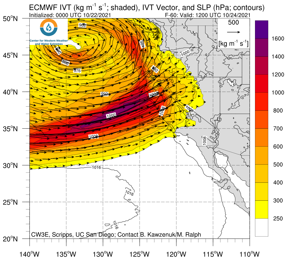
This moisture delivery system will be in the form of a strong atmospheric river.

In fact, according to the recently-developed AR-Cat scoring system, the Sunday event will likely be an “AR-Cat 5” event. That’s the highest possible rating, although atmospheric rivers can potentially be much stronger still and well above the top end of the scale. Professionally, I do have some concerns that the present AR rating system doesn’t do a great job of actually signifying potential impacts (especially in a warming climate), but suffice it to say: this will be an impressive AR for any time of year, let alone this early in the season (i.e., October).

Stormy conditions are expected to begin early Sunday and ramp up through the day in NorCal. Strong warm advection ahead of a robust cold front, plus the entrainment of some subtropical moisture in the AR plume, will yield a rather warm airmass–raising snow levels to well above pass level in the Sierra Nevada. In fact, rain may fall as high as 10,000 feet during the first half (and most intense) portion of the storm before crashing later in the event. A surface low offshore and to the northwest of CA, combined with a respectable jet streak over NorCal, will lead to very efficient orographic and frontal lifting during the peak of the event Sunday evening. As a result, widespread moderate orographic precipitation (locally heavy) will turn into a widespread heavy rain event for a period later on Sunday as the cold front and AR core approaches. Very intense rainfall rates of 1/2 to 1 inch per hour will be possible for a couple of hours around frontal passage just about everywhere, and for quite a few consecutive hours in the orographically favored areas.


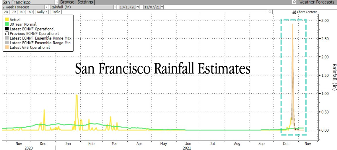
The weekend storm will bring very heavy rainfall to a broad swath of Northern California, especially the northern/central Sierra Nevada and northern Coast Range.

Strong and gusty winds (perhaps to 40-50 mph or so in some places), and maybe some isolated thunderstorms, will likely accompany the cold front–although widespread damaging winds are not expected with this event. I would expect peak rainfall rates around the time of cold frontal passage to be high enough to cause some urban/small stream flooding in parts of NorCal, although widespread significant flooding is not expected due to very dry antecedent conditions in most places. Prior to this week’s rain, soils were at/near record dryness levels and rivers were also at/near record low levels–so there will still be a lot of capacity for the ground to absorb a lot of this water (which is why river flooding is not expected anywhere, despite very intense rainfall). Some parts of NorCal that have seen 3-5+ inches of rainfall this week may see somewhat faster rises on rivers than elsewhere, and perhaps an increased likelihood of small stream flooding, but in general the flood risk with this event will primarily be on small/flashy watersheds and in urban settings. Flash Flood Watches have already been issued by various NWS offices in NorCal for a broad swath of the state, although most of these are primarily intended to target the recent wildfire burn areas (which are, decidedly, numerous and extensive).

The very wettest places in NorCal, especially the western slopes of the Northern Sierra near the Feather River watershed, could locally see 10-13 inches of rainfall by Monday morning (!). Parts of the SF North Bay could easily see 5-7 inches, and much of NorCal will see at least 1-2 inches. That is very impressive indeed for a single storm in October! SLO and SB counties could see a solid 1-2 inch soaking, but most of Southern California will see much less precipitation (<1 inch nearly everywhere) than NorCal. Still, some rain will likely still fall at least as far south as Los Angeles–moderating, but likely not ending, fire season across SoCal.

Snow levels will eventually drop and bring substantial snowfall to the Sierra Nevada at/below pass level, but a majority of the liquid equivalent will likely first fall as rain before the colder air arrives. Still, I’d expect a respectable late October snowpack above 6-7k feet following this event.

1635043781367.png

Significant flood/debris flow risk in recent NorCal wildfire burn areas
A major exception to the “relatively low flood risk” mentioned above will be near wildfire burn areas. While I’d mostly expect this storm to be net beneficial (in terms of drought/fire season mitigation), very heavy rainfall is likely on steep slopes in intensely burned portions of Dixie, Caldor, other recent fire footprints.

Concern has rapidly escalated that portions of the Hwy 50 and Hwy 70 corridor, in particular, could be severely affected by some combination of flash flooding, debris flows, and mudslides during the Sunday storm. There could potentially be substantial damage to transportation and utility infrastructure in the most intensely burned portions of recent (i.e. 2021, but perhaps also 2020) fire footprints, as well as risk to towns immediately within or downstream from these areas.

1635043837181.png
1635043873914.png

Why am I especially concerned about post-fire hydrologic hazards with this event? First, the very most intense precipitation will occur precisely where the largest and most intensely burned fire footprints exist along the western slopes of the Sierra Nevada. Hourly rainfall *rates* will also be quite high near the peak of the event, perhaps 1 inch/hr or even locally a bit higher. Second, the most intense portion of this atmospheric will be quite warm, with snow levels around 10,000 feet. This means that some higher elevation portions of the burn areas that might more typically see snow at this time of year will see rain instead, with substantial runoff. Thirdly, the Dixie and Caldor Fire footprints in particular encompass some very steep terrain that has been historically prone to slope instability even in the absence of fire activity. All this is to say: if you live within or near a 2020 (or especially 2021) fire footprint in northern or central CA, please be aware of the possibility of major debris flows that could be dangerous and/or disrupt transportation for an extended period. Risks are highest for the most recent (i.e., 2021) fire zones, but could locally extend into some of the 2020 footprints as well (which could includes parts of the SF North Bay, Santa Cruz Mountains, etc.).

Although this storm will be much weaker in SoCal, a brief period of moderate to heavy rainfall may occur over the steep ocean-facing slopes of the Transverse Ranges and there will be some risk of debris flows within the very recent Alisal Fire footprint in SB County as well–possibly affecting Hwy 101 at some point on Monday.

Substantial drying trend beginning next week, though occasionally unsettled conditions could continue

I won’t spend much time on the long range outlook this time, but conditions do look to dry out considerably heading into the end of October and early November. There may be a couple opportunities for more typical autumn-like showers, but otherwise, things look…pleasantly unremarkable following this weekend’s heavy rains. At this point, I am reasonably optimistic I won’t be talking about fire risk in NorCal for the rest of the season, and in SoCal for at least a couple of weeks…
 

Doomer Doug

TB Fanatic
Here is the Federale official Portland weather forecast web page.


Heavy rain, 100% chance on Sunday and 100% on Monday.

Yep FOUR days of rain in a row in the Pacific NW pretty much everywhere you go. Good thing I'm a prepper so I can just sit around and read, or if I have power dink around online. :D
 
Status
Not open for further replies.
Top