ALERT 6 Dams at Serious Risk of Failing from Montana to Missouri - Expert says

awakeaware

Inactive
some serious things are going on right now the MSM is not touching.

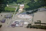
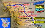
Dams all the way to Montana are right now at a huge risk for failing. The dams are all filled to the brim starting at Fort Peck in Montana. We are talking about what Edgar Cayce had said where the U.S. is cut in half and that would happen. St. Louis would be wiped out and waist deep in water.

here is one article about it.

http://stlouis.cbslocal.com/2011/06/...l-proportions/

here is an expert talking about it and saying it is a real possibility!

http://www.youtube.com/watch?v=0XV72...layer_embedded

Many nuclear plants along this area, the whole infrastructure of utilities/energy could be wiped out.
 

FREEBIRD

Has No Life - Lives on TB
There is already enough trouble from levees breaching, etc. and if Gavins Point Dam fails, it's very bad for Yankton, Sioux City, Omaha/Council Bluffs, Offutt AFB (Stratcom), a couple of nuclear power plants, and everything else downstream.

I can't imagine the devastation if upper dams fail and the lower ones go like dominoes. But I've got a front row seat.
 

Bad Hand

Veteran Member
There is a nuclear power plant in Nebraska that had an indecent already and they are trying to protect it from the flood waters that are coming. Maybe building nuclear power plants in flood zones isn't such a good idea.
 

NWPhotog

Veteran Member
In windy conditions, waves regularly crest over the top of the spillway . . have ever since I was a young boy. That is not the top of the dam, that is the top of the spillway. . .major difference.. . .not to panic about that.
 
Here the closest dam (of two) is spilling 100,000 cubic feet per second, almost 2.7 billion gallons per hour.

That figure was from three days ago, the water is still rising.

ETA - current warning

925 AM MDT SAT JUN 11 2011

THE NATIONAL WEATHER SERVICE IN MISSOULA HAS EXTENDED THE

* FLOOD WARNING FOR THE CLARK FORK RIVER NEAR PLAINS...
CENTRAL SANDERS COUNTY.

* UNTIL FURTHER NOTICE.

* AT 8:45 AM SATURDAY THE STAGE WAS 16.4 FEET.

* FLOOD STAGE IS 16.0 FEET.

* FORECAST...THE RIVER WILL REMAIN ABOVE FLOOD STAGE THROUGH THE
WEEKEND.

===

.
 
Last edited:

awakeaware

Inactive
Some more links about what is happening. I don't understand how MSM is not talking about this at all. They are only on the Weiner info and always things that are micro and do not affect people on a whole. Yet the big stories are never told where thousands and possibly millions (if dams fail) are affected.

It is from local papers of the midwest and areas affected that are carrying news about it.

Here is FEMA's update of situations list.

http://www.fema.gov/emergency/reports/2011/nat060911.shtm

http://www.deseretnews.com/article/700143111/At-full-flow-mighty-Missouri-puts-on-show.html?pg=1

http://sayanythingblog.com/entry/wa...-river-dams-more-at-risk-than-they-are-today/

http://www.publicbroadcasting.net/k...sidents.evacuate.along.swollen.Missouri.River

This site has it by area around Montana and Iowa of what is happening. Also Montana has asked for a state of emergency to be declared.

http://www.uncoverage.net/2011/06/m...-flooded-iowa-farmers-to-build-their-own-dam/
 

RCSAR

Veteran Member
If they do fail and flood all the way down to the New Madrid area. That is going to add a lot of weight , water is heavy.

Wonder how it will effect the fault?
 

ka5gtc

Contributing Member
My son and daughter inlaw live in Council Bluff and I call often to check . They have a new house and both work in the area . I worry about them but know that only the Lord can protect them. I live in hurricane central and we have time and a place to go. The kids dont have a place and if things go south they wont have time either. My son said that they were told that if they flood that the water would stay for months. All we can do is pray.
 

Red Baron

Paleo-Conservative
_______________
Some more links about what is happening. I don't understand how MSM is not talking about this at all. They are only on the Weiner info and always things that are micro and do not affect people on a whole. Yet the big stories are never told where thousands and possibly millions (if dams fail) are affected.

The MSM has a distict West Coast/East Coast bias and generally distains anything to do with us in "flyover" country.

Only until there is a large loss of life will the MSM cover it.
 

Bad Hand

Veteran Member
Today it is 48 and raining but it looks likes it is snowing in the mountains. The cold temperatures are slowing the snow melt but allowing the snow pack to continue to build.
 

tanstaafl

Has No Life - Lives on TB
So, what are the six dams (and where are they located) from the original post?

Not that this is imminent, but the TV program Mega Disasters has an episode called "Dam Break" (2008), which is a hypothetical worst-case scenario disaster where multiple dams fail above Eugene (Oregon) after an earthquake causes a landslide into a lake (sort of a mini-Cumbra de Vieja in the Canary Islands scenario).
 

Lone Eagle Woman

Veteran Member
Yes here in the Rockies, the rain and snow continue to fall. And in many ways, the runoff has yet to begin for the snow that is in the High Country. Here in Jackson Hole, all the mountains round about are still covered with snow. At the Snowbird Resort in Utah, the snowpack is 525% above normal. The snowpack here in the Snake River Drainage is almost 400% of normal. Lately it has been nothing but raining and snowing continuing up in Montana and here locally in JH. And the forecast if one looks for the Northern Rockies with the adjacent Northern Plains in for this Rain and Snow with cooler temps to continue for the next foreseeable future. This does not look good when it comes to these dams. If one breaks then everything downstream from there to the Gulf of Mexico will be nothing but flooding and more flooding.

By the Snotel Sites, here is some of the percentages in the River Drainage System affecting these dams ....

Missouri Mainstem Rver Basin (Montana) - 548 %
Smith, Judith,, and Musselshell River Basins (Montana) - 805 %
Headwaters Missouri Mainstem (Montana) - 626 %
Missouri Headwaters - 329 %

(Do Not Know the difference in the above listings - just different listing on the snotel sites page)

Upper Yellowstone River Basin (Mt. and Wy.) - 291 %
Bighorn River Basin (Wyoming) - 331 %
Tongue River Basin (Wyoming) - 964 %
Powder River Basin (Wyoming) - 700 %
Sun, Teton, and Marias River Basin (Montana) - 385 %
Jefferson River Basin (Montana) - 329 %
Madison River Basin - 320 %
Gallatin River Basin - 301 %

Montana Snotel Link .... http://www.wwrc.uwyo.edu/wrds/nrcs/updatesur/update-mt.html
 
Last edited:

Sleeping Cobra

TB Fanatic
In windy conditions, waves regularly crest over the top of the spillway . . have ever since I was a young boy. That is not the top of the dam, that is the top of the spillway. . .major difference.. . .not to panic about that.

It's amazing how much stress dams take.
 

Lone Eagle Woman

Veteran Member
Here is a related article on this over at the website ....Ice Age Now (http://www.iceagenow.com)

The article is entitlled:

"Missouri River, Second 500 Year Flood in 15 Years, Could Continue thru Mid August

And the url is ....www.iceagenow.com with being the third article from the top as of Sunday.

There is lots of links over at this link at article at Ice Age Now.
 

PCViking

Lutefisk Survivor

Attachments

  • Calhoun.jpg
    Calhoun.jpg
    19.8 KB · Views: 367
  • USA_Missouri_Map_Nuclear_Power_Plan_and_Dam.jpg
    USA_Missouri_Map_Nuclear_Power_Plan_and_Dam.jpg
    117 KB · Views: 366

changed

Preferred pronouns: dude/bro
Something for all of you to ponder. Not all of the snow in the mountains has melted yet.
 

FREEBIRD

Has No Life - Lives on TB
Ask yourselves why, if there is an Obama-ordered "blackout" on the nuclear power plants, the Omaha World-Herald is continuing to front-page the story (#23)?
 

PCViking

Lutefisk Survivor
local news... FB. Everybody in Omaha knows what's going on... no use hiding it there...

Here FB is what I should have posted:

http://www.myweathertech.com/2011/0...lackout-over-crippled-nebraska-nuclear-plant/

US Orders News Blackout Over Crippled Nebraska Nuclear Plant

A shocking report prepared by Russia’s Federal Atomic Energy Agency (FAAE) on information provided to them by the International Atomic Energy Agency (IAEA) states that the Obama regime has ordered a “total and complete” news blackout relating to any information regarding the near catastrophic meltdown of the Fort Calhoun Nuclear Power Plant [photo top left] located in Nebraska.

According to this report, the Fort Calhoun Nuclear Plant suffered a “catastrophic loss of cooling” to one of its idle spent fuel rod pools on 7 June after this plant was deluged with water caused by the historic flooding of the Missouri River which resulted in a fire causing the Federal Aviation Agency (FAA) to issue a “no-fly ban” over the area.

Follow link for rest of story.

:vik:
 

PCViking

Lutefisk Survivor
Ya know BK... it would really suck if something like that happened... I've seen a lot of potential crisis not happen and I hope this one passes too.

The fact of the matter is that the dams all along the Big MO are at capacity... like they have never experienced before. Do your fluid statics and you'll see that is a problem. The Army Corps of Engineers data is easy to find on the internet.

:vik:
 
Last edited:

night driver

ESFP adrift in INTJ sea
PCViking, you ARE aware that that story is a Scorcha Fall story, right????

It's about 2 weeks old and has been traced back to him.....
 

changed

Preferred pronouns: dude/bro
Yes thank you. I wrote the names of the dams down and i want to keep an eye on youtube of updates.

Sleeping Cobra, do a wikipedia search on those dams and the lakes they form and you will be amazed at the area of them in a normal year. Lake Oahe alone is 300,000+ acres in size.
 

Karnie

Veteran Member
local news... FB. Everybody in Omaha knows what's going on... no use hiding it there...

Here FB is what I should have posted:

http://www.myweathertech.com/2011/0...lackout-over-crippled-nebraska-nuclear-plant/

US Orders News Blackout Over Crippled Nebraska Nuclear Plant

A shocking report prepared by Russia’s Federal Atomic Energy Agency (FAAE) on information provided to them by the International Atomic Energy Agency (IAEA) states that the Obama regime has ordered a “total and complete” news blackout relating to any information regarding the near catastrophic meltdown of the Fort Calhoun Nuclear Power Plant [photo top left] located in Nebraska.

According to this report, the Fort Calhoun Nuclear Plant suffered a “catastrophic loss of cooling” to one of its idle spent fuel rod pools on 7 June after this plant was deluged with water caused by the historic flooding of the Missouri River which resulted in a fire causing the Federal Aviation Agency (FAA) to issue a “no-fly ban” over the area.

Follow link for rest of story.

:vik:

Horse hockey. There have been quite a few national reports. Reuters has reported on this recently. ABC has reported that the electricity is cut off due to the levee breach. The NY Times has reported. Some "total and complete" news blackout.
 
Top