It is a fall noreaster. Until recently we get them every year. Now we get bomb cyclones which are the end of the world. Get your milk and your beer and you are all set. Yes we will lose power, trees will come down and there will be flooding but it happens every year. No snow. All rain from what I can see.So, this is happening now?
Anyone on the coast reporting snow, or just rain?
Thanks.

You are using an out of date browser. It may not display this or other websites correctly.
You should upgrade or use an alternative browser.
You should upgrade or use an alternative browser.
Volcano Update 2 - Additional vents opening -Volcano on La Palma island in the Canary Islands has erupted
- Thread starter Warm Wisconsin
- Start date
Lilbitsnana
On TB every waking moment
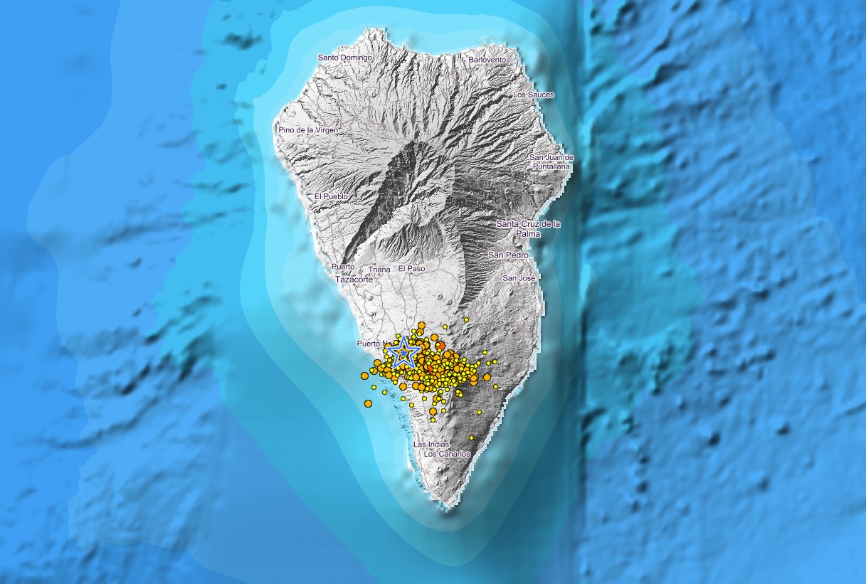
Earthquake data: Mag 4.2 / 36.0 km (22 mi) depth
7 hours ago reported felt
Oct 26, 2021 06:05 GMT, Oct 26, 2021 7:05 am (GMT +1) local time
Lat / Lng: 28.5782 / -17.8062: La Palma Island, Spain
Source: IGN
Other sources: EMSC: 4.1 / 40 km
7 hours ago reported felt
Oct 26, 2021 06:05 GMT, Oct 26, 2021 7:05 am (GMT +1) local time
Lat / Lng: 28.5782 / -17.8062: La Palma Island, Spain
Source: IGN
Other sources: EMSC: 4.1 / 40 km
That was interesting and a bit troubling....Well, THIS blew my mind!! ....
THIS VIDEO GAME SECRET FILES 2 WAS MADE YEARS AGO IN 2009 ABOUT WHAT WE ARE SEEING TODAY WITH THE VOLCANIC ERUPTION ON LA PALMA, ARE YOU AWAKE YET? YOU CAN DISMISS THIS AS JUST A GAME OR CONSPIRACY THEORY , OR YOU COULD SAY THAT
LA PALMA PREDICTIVE PROGRAMMING FROM THE GAME SECRET FILES 2 DESTROYING THE USA WITH A TUSNAMI
R/T 1:40
View: https://www.youtube.com/watch?v=R7tajUITIFk
Samuel Adams
Has No Life - Lives on TB
That was interesting and a bit troubling....
Now.......don’t you become a believer, especially immediately following that scathing review regarding government imposed earthquakes !!

It's just interesting that this video is 12 years old. As far as the manufactured quakes, that's a whole different story. The grid pattern is because geologists placed the sensors in that pattern because I think they are scared.Now.......don’t you become a believer, especially immediately following that scathing review regarding government imposed earthquakes !!
Samuel Adams
Has No Life - Lives on TB
I agree with all of your assessments herein, for the record.....
cyberiot
Rimtas žmogus
It is a fall noreaster. Until recently we get them every year. Now we get bomb cyclones which are the end of the world. Get your milk and your beer and you are all set. Yes we will lose power, trees will come down and there will be flooding but it happens every year. No snow. All rain from what I can see.
Never heard of bomb cyclones until about a week ago. Now ya can't open your car door without hitting one.
Warm Wisconsin
Easy as 3.141592653589..
It's just interesting that this video is 12 years old. As far as the manufactured quakes, that's a whole different story. The grid pattern is because geologists placed the sensors in that pattern because I think they are scared.
REAL EXPLANATION: That website maps earthquake position (co-ordinates) in degrees and minutes, but not seconds. Each degree within the tropics spans about 40000/360=111 kilometers and each minute of arc spans about 111/60=1.85 kilometers. It is this 1.85 km grid that you see! ... If the grid system was not used with so many earthquakes, the map would show one giant red clump.
TheSearcher
Are you sure about that?
It's just interesting that this video is 12 years old. As far as the manufactured quakes, that's a whole different story. The grid pattern is because geologists placed the sensors in that pattern because I think they are scared.
Are saying that the sensors were recently placed, due to the recent activity?
I have no idea.Are saying that the sensors were recently placed, due to the recent activity?
TheSearcher
Are you sure about that?
I have no idea.
I'm just trying to figure out why the scientists being scared results in a grid pattern. Really, I'm just trying to understand what you mean.
Lilbitsnana
On TB every waking moment
I haven't seen anything yet other than from Bushcraft Bear, so ?? ETA: legit, maybe even two of them ETA2: revised down to 4.7 eq, with adjusted depth between the two readings
BushcraftBear
@BushcraftBearLP
·
18s
Earthquake Monitor website says 4.8Magnitude. But that can change.
ETA: it could still be revised up/down and location could be revised as well
BushcraftBear
@BushcraftBearLP
·
18s
Earthquake Monitor website says 4.8Magnitude. But that can change.
ETA: it could still be revised up/down and location could be revised as well
| 2021-10-26 16:25:36.4Earthquake, Magnitude 4.7 - CANARY ISLANDS, SPAIN REGION - 2021 October 26, 16:25:34 UTC |
| 09min ago | 28.52 | N | 17.79 | W | 58 | 4.8 | CANARY ISLANDS, SPAIN REGION |
Last edited:
Lilbitsnana
On TB every waking moment
I haven't seen anything yet other than from Bushcraft Bear, so ?? ETA: yep, showing now, maybe two of them.
BushcraftBear
@BushcraftBearLP
·
18s
Earthquake Monitor website says 4.8Magnitude. But that can change.
nana note: ETA: it could still be revised up/down and location could be revised as well
ETA2: revised down to 4.7 with adjusted depth
2021-10-26 16:25:36.4Earthquake, Magnitude 4.8 - CANARY ISLANDS, SPAIN REGION - 2021 October 26, 16:25:36 UTC
09min ago 28.52 N 17.79 W 58 4.8 CANARY ISLANDS, SPAIN REGION
just above SouthEastern tip of island (towards bottom of island) ETA 4:43 PM CDT: They moved location of quake from bottom of island to Northern 1/3 section NW of airport. (east side of island)
| Oct 26, 2021 5:25 pm (GMT +1) (Oct 26, 2021 16:25 GMT) 13 minutes ago | 4.8 58 km | La Palma Island, 20 km southeast of Los Llanos de Aridane, Spain I FELT IT - 42 reports |
Last edited:
This would allow them to plot where the deep quakes are and where the more intense quakes are rather than just knowing that there was an earthquake somewhere on the island.I'm just trying to figure out why the scientists being scared results in a grid pattern. Really, I'm just trying to understand what you mean.
Lilbitsnana
On TB every waking moment
I don't know why they are now showind two 4.8 EQs at same time very close together, I assume something will changes. Either revised up a bunch as one EQ, maybe one will be eliminated after location narrowed down, or both will remain ?? Not sure. Big elevation/depth difference, so most likely two.
ETA: revised down to one 4.7 with adjusted depth
Map
ETA: revised down to one 4.7 with adjusted depth
| Oct 26, 2021 16:25 GMT 17 minutes ago | 4.8 34 km | Spain: E FUENCALIENTE DE LA PALMA.ILP I FELT IT |
| Map | |||
| Oct 26, 2021 16:25 GMT 17 minutes ago | 4.8 58 km | Near Los Llanos de Aridane, Canary Islands, Spain I FELT IT |
La Palma Island Earthquakes Today: Latest Quakes Past 24 hours
Latest quakes on or near La Palma Island now or today. See if there was a quake on or near La Palma Island just now! Find how many recent quakes there were, report a quake if you felt one!
www.volcanodiscovery.com
Last edited:
Lilbitsnana
On TB every waking moment
Got Bushcraft Bear's attention
BushcraftBear
@BushcraftBearLP
·
21m
EARTHQUAKE ALERT!!! Strongest one I did feel since the eruption. That was scary.
BushcraftBear
@BushcraftBearLP
·
21m
The whole ground was shaking.
BushcraftBear
@BushcraftBearLP
·
21m
EARTHQUAKE ALERT!!! Strongest one I did feel since the eruption. That was scary.
BushcraftBear
@BushcraftBearLP
·
21m
The whole ground was shaking.
Lilbitsnana
On TB every waking moment
This Bushcraft Bear video was BEFORE the 4.8 (adjusted down to 4.7). (ETA: LOL had huge typo "40" instead of "to")
Ground in south La Palma increased 10 centimeters. The volcano as active as never before. 4.2 quake.
11 min 41 sec
View: https://www.youtube.com/watch?v=oTu8s8SOFoI
Ground in south La Palma increased 10 centimeters. The volcano as active as never before. 4.2 quake.
11 min 41 sec
Last edited:
It appears that there were two since they are different locations (but close to each other). To me (completely untrained) this would be an escalation.I don't know why they are now showind two 4.8 EQs at same time very close together, I assume something will changes. Either revised up a bunch as one EQ, maybe one will be eliminated after location narrowed down, or both will remain ?? Not sure. Big elevation/depth difference, so most likely two.
Oct 26, 2021 16:25 GMT
17 minutes ago4.8
34 kmSpain: E FUENCALIENTE DE LA PALMA.ILP
I FELT IT
Map
Map Oct 26, 2021 16:25 GMT
17 minutes ago4.8
58 kmNear Los Llanos de Aridane, Canary Islands, Spain
I FELT IT
La Palma Island Earthquakes Today: Latest Quakes Past 24 hours
Latest quakes on or near La Palma Island now or today. See if there was a quake on or near La Palma Island just now! Find how many recent quakes there were, report a quake if you felt one!www.volcanodiscovery.com
Lilbitsnana
On TB every waking moment
It appears that there were two since they are different locations (but close to each other). To me (completely untrained) this would be an escalation.
They revised it down to one 4.7 with the depth adjusted between the previously reported two. Sensor locations and the timing difference in monitors registering is why reports end up being revised after analysis.
Lilbitsnana
On TB every waking moment
various scenes from today
INVOLCAN
@involcan
·
59m
Imágenes de la erupción a las 18.20 (hora canaria) desde Tacande, en las que se observa la emisión de piroclastos / Footage of the eruption at 6:20 p.m. (Canarian time) from Tacande, in which the emission of pyroclasts is observed #LaPalma
1 min 19 sec
INVOLCAN
@involcan
·
39m
La actividad de hace unos minutos contrasta con la aparente tranquilidad registrada ahora mismo a las 18.45 (hora canaria) / The activity of a few minutes ago contrasts with the apparent tranquility recorded right now at 6:45 p.m. (Canarian time) #LaPalma
40 sec
INVOLCAN
@involcan
·
32m
El cono interno ha colapsado sobre sí mismo. En este vídeo de las 18.50 (hora canaria) se observa el actual e imponente penacho volcánico/The inner cone has collapsed on itself. In this video recorded at 6.50 pm (Canarian time) the current and imposing volcanic plume can be seen
1 min 09 sec
INVOLCAN
@involcan
·
59m
Imágenes de la erupción a las 18.20 (hora canaria) desde Tacande, en las que se observa la emisión de piroclastos / Footage of the eruption at 6:20 p.m. (Canarian time) from Tacande, in which the emission of pyroclasts is observed #LaPalma
1 min 19 sec
INVOLCAN
@involcan
·
39m
La actividad de hace unos minutos contrasta con la aparente tranquilidad registrada ahora mismo a las 18.45 (hora canaria) / The activity of a few minutes ago contrasts with the apparent tranquility recorded right now at 6:45 p.m. (Canarian time) #LaPalma
40 sec
INVOLCAN
@involcan
·
32m
El cono interno ha colapsado sobre sí mismo. En este vídeo de las 18.50 (hora canaria) se observa el actual e imponente penacho volcánico/The inner cone has collapsed on itself. In this video recorded at 6.50 pm (Canarian time) the current and imposing volcanic plume can be seen
1 min 09 sec
packyderms_wife
Neither here nor there.
This Bushcraft Bear video was BEFORE the 4.8 (adjusted down 40 4.7).
Ground in south La Palma increased 10 centimeters. The volcano as active as never before. 4.2 quake.
He also said that the other side of the island deflated/deflected several CMs.
Lilbitsnana
On TB every waking moment
He also said that the other side of the island deflated/deflected several CMs.
Yes, he just didn't include that info in the header of the video.
packyderms_wife
Neither here nor there.
Yes, he just didn't include that info in the header of the video.
Most don't watch the videos they only read the synopsis and title, hence my comment about the decrease on the other side of the island.
What do you think is happening with one side rising and the other side sinking? I don't think I've ever heard of that. Please let me know what you think.Most don't watch the videos they only read the synopsis and title, hence my comment about the decrease on the other side of the island.
packyderms_wife
Neither here nor there.
What do you think is happening with one side rising and the other side sinking? I don't think I've ever heard of that. Please let me know what you think.
Not a clue, other than my Tambora comparison.
RememberGoliad
Veteran Member
What do you think is happening with one side rising and the other side sinking? I don't think I've ever heard of that. Please let me know what you think.
Hank Johnson's probably lookin' a little smug right now

TheSearcher
Are you sure about that?
That copious amount of steam bothers me.
Lilbitsnana
On TB every waking moment
text and video from Bushcraft Bear

BushcraftBear
@BushcraftBearLP
·
3m
WATCH OUT!! Official warning of landslides and stronger earthquakes! There was a M4.7 this afternoon
9 min 23 sec
WATCH OUT!! Official warning of landslides and stronger earthquakes! There was a M4.7 this afternoon
BushcraftBear
@BushcraftBearLP
·
3m
WATCH OUT!! Official warning of landslides and stronger earthquakes! There was a M4.7 this afternoon
9 min 23 sec
WATCH OUT!! Official warning of landslides and stronger earthquakes! There was a M4.7 this afternoon
Lilbitsnana
On TB every waking moment
always subject to change on both magnitude and location, but a 4.1 for now (they have already downgraded some other 4 plus ones today, so, might downgrade this one too)
ETA: FOR NOW IGNORE THIS, they have placed it on neighboring island, not La Palma, but in case it gets moved again, leaving this for now.
Map
ETA: FOR NOW IGNORE THIS, they have placed it on neighboring island, not La Palma, but in case it gets moved again, leaving this for now.
| Tuesday, October 26, 2021 22:29 GMT (75 earthquakes) | |||
| Oct 26, 2021 11:29 pm (GMT +1) (Oct 26, 2021 22:29 GMT) 14 minutes ago | 4.1 14 km | Spain: SW SANTIAGO DEL TEIDE.ITF I FELT IT |
packyderms_wife
Neither here nor there.
always subject to change on both magnitude and location, but a 4.1 for now (they have already downgraded some other 4 plus ones today, so, might downgrade this one too)
ETA: FOR NOW IGNORE THIS, they have placed it on neighboring island, not La Palma, but in case it gets moved again, leaving this for now.
Map
Tuesday, October 26, 2021 22:29 GMT (75 earthquakes) Oct 26, 2021 11:29 pm (GMT +1) (Oct 26, 2021 22:29 GMT)
14 minutes ago4.1
14 kmSpain: SW SANTIAGO DEL TEIDE.ITF
I FELT IT
I wonder if this is the true reason why the USGS isn't reporting on the La Palma quakes?
Lilbitsnana
On TB every waking moment
I wonder if this is the true reason why the USGS isn't reporting on the La Palma quakes?
I don't know.
I thought maybe USGS doesn't report them anymore because being a volcano it produces so very many quakes from magma movement, unlike normal quakes.
Or maybe some kind of agreement with European monitoring sites to limit reports.
Warm Wisconsin
Easy as 3.141592653589..
I don't know.
I thought maybe USGS doesn't report them anymore because being a volcano it produces so very many quakes from magma movement, unlike normal quakes.
Or maybe some kind of agreement with European monitoring sites to limit reports.
The European geological team is much smaller than the USGS team. The USGS doesn’t have any responsibility to review earthquakes outside of their areas of interest, however they do it if they have the bandwidth at that time. In a case like this the European team will dedicate staff to review the earthquakes for accuracy, since this is an event inside their area of responsibility.
The computer kicks out a generalized report and then humans review it and update it. There is no reason to have both agencies review the same earthquake. So the USGS bows out.
The two 4.7 earthquakes earlier was two seismic stations reporting the same earthquake in two different locations. Humans reviewed it and determined only one earthquake occurred, so they deleted one.
Last edited:
Lilbitsnana
On TB every waking moment
The European geological team is much smaller than the USGS team. The USGS doesn’t have any responsibility to review earthquakes outside of their areas of interest, however they do it if they have the bandwidth at that time. In a case like this the European team will dedicate staff to review the earthquakes for accuracy, since this is an event inside their area of responsibility.
The computer kicks out a generalized report and then humans review it and update it. There is no reason to have both agencies review the same earthquake. So the USGS bows out.
The two 4.7 earthquakes earlier was so seismic stations reporting the same earthquake in two different locations. Humans reviewed it and determined only one earthquake occurred, so they deleted one.
I get the analyzing data to refine reports. There is more than one European agency with monitors on the island.
Lilbitsnana
On TB every waking moment
always subject to change on both magnitude and location, but a 4.1 for now (they have already downgraded some other 4 plus ones today, so, might downgrade this one too)
ETA: FOR NOW IGNORE THIS, they have placed it on neighboring island, not La Palma, but in case it gets moved again, leaving this for now.
Map
Tuesday, October 26, 2021 22:29 GMT (75 earthquakes) Oct 26, 2021 11:29 pm (GMT +1) (Oct 26, 2021 22:29 GMT)
14 minutes ago4.1
14 kmSpain: SW SANTIAGO DEL TEIDE.ITF
I FELT IT
moved to la Palma as two quakes a minute or two apart. A 3.0 and a 3.2
Lilbitsnana
On TB every waking moment

Warm Wisconsin
Easy as 3.141592653589..
I get the analyzing data to refine reports. There is more than one European agency with monitors on the island.
I see. Yes - European-Mediterranean Seismological Centre (EMSC) and the European Geological Survey (EGS) both have monitors. Usually, EGS will add extra sensors to volcanoes to get additional information the EMSC can’t provide.
danielboon
TB Fanatic
Not good
Lilbitsnana
On TB every waking moment
Initially being reported as a 4.6 by EMSC-CSEM. (volcano discovery not showing it yet)
ETA 7:27 PM CDT: upgraded to a 4.8 (see post #1163 for more info)
I see. Yes - European-Mediterranean Seismological Centre (EMSC) and the European Geological Survey (EGS) both have monitors. Usually, EGS will add extra sensors to volcanoes to get additional information the EMSC can’t provide.
There is a Spanish or a Canary Islands agency that has their own monitors too,
Last edited:
packyderms_wife
Neither here nor there.
Initially being reported as a 4.6 by EMSC-CSEM. (volcano discovery not showing it yet)
There is a Spanish or a Canary Islands agency that has their own monitors too,
And the guy in charge of it resigned today, citing he wanted to leave the island. Seems like the sound of the volcano is getting to the locals after what 29 days now?
Lilbitsnana
On TB every waking moment
And the guy in charge of it resigned today, citing he wanted to leave the island. Seems like the sound of the volcano is getting to the locals after what 29 days now?
I think it is day 38 or 39. I wonder just what their research since this started shows.