Volcano Update 2 - Additional vents opening -Volcano on La Palma island in the Canary Islands has erupted

Lilbitsnana

On TB every waking moment
From what I've been reading on various sites they don't think it's going to stop erupting before the end of the year.

Yep. I posted a week or so ago that the scientists said the magma chamber study showed it would last until sometime in Mid January of 2022.

It has had a few "refills" for lack of a better word, since then, so I don't know how long they think it will last now.

They did start talking more about months and how historically one lasted for years.
I'm very curious what the latest data shows them.
 

Lilbitsnana

On TB every waking moment
Initially being reported as a 4.6 by EMSC-CSEM. (volcano discovery not showing it yet)


There is a Spanish or a Canary Islands agency that has their own monitors too,

Upgraded to a 4.8

Moderate mag. 4.8 earthquake - La Palma Island, 15 km southeast of Los Llanos de Aridane, Spain, on Wednesday, Oct 27, 2021 12:53 am (GMT +1) - 25 minutes ago

Updated: Wed, Oct 27, 2021 00:16 GMT - 103 seconds ago

Overview | Quake Data | Interactive map | User Reports | Earlier quakes here | Quakes in Spain | Canary Islands
Moderate mag. 4.8 earthquake - La Palma Island, 15 km southeast of Los Llanos de Aridane, Spain, on Wednesday, Oct 27, 2021 12:53 am (GMT +1)
Moderate magnitude 4.8 earthquake at 33 km depth

26 Oct 23:55 UTC: First to report: VolcanoDiscovery after 2 minutes.
26 Oct 23:56: Now using data updates from EMSC
26 Oct 23:58: Now using data updates from IGN
27 Oct 00:16: Magnitude recalculated from 4.6 to 4.8. Hypocenter depth recalculated from 23.0 to 33.0 km (from 14.3 to 21 mi). Epicenter location corrected by 16 km (9.7 mi) towards N.

Update Wed, 27 Oct 2021, 00:00
Moderate magnitude 4.6 quake hits 28 km southeast of Los Llanos de Aridane, Spain after midnight
4.6 quake 27 Oct 12:53 am (GMT +1)

4.6 quake 27 Oct 12:53 am (GMT +1)
An earthquake of magnitude 4.6 occurred only 7 minutes ago 28 km southeast of Los Llanos de Aridane, Spain, Spain's Instituto Geográfico Nacional (IGN) reported.
The quake hit at a shallow depth of 23 km beneath the epicenter near Los Llanos de Aridane, La Palma Island, Canary Islands, Spain, after midnight on Wednesday, October 27th, 2021, at 12:53 am local time. The exact magnitude, epicenter, and depth of the quake might be revised within the next few hours or minutes as seismologists review data and refine their calculations, or as other agencies issue their report.
A second report was later issued by the European-Mediterranean Seismological Centre (EMSC), which listed it as a magnitude 4.6 earthquake as well.
Based on the preliminary seismic data, the quake should not have caused any significant damage, but was probably felt by many people as light vibration in the area of the epicenter.
Weak shaking might have been felt in Fuencaliente de la Palma (pop. 1,900) located 8 km from the epicenter, Mazo (pop. 4,800) 21 km away, Breña Baja (pop. 4,200) 23 km away, Brena Alta (pop. 7,100) 26 km away, El Paso (pop. 7,100) 26 km away, Tazacorte (pop. 5,700) 27 km away, Los Llanos de Aridane (pop. 20,800) 28 km away, and Santa Cruz de La Palma (pop. 17,100) 30 km away.
VolcanoDiscovery will automatically update magnitude and depth if these change and follow up if other significant news about the quake become available. If you're in the area, please send us your experience through our reporting mechanism, either online or via our mobile app. This will help us provide more first-hand updates to anyone around the globe who wants to know more about this quake.
If you were or still are in this area during the quake help others with your feedback and report it here.
Download the Volcanoes & Earthquakes app and get one of the fastest seismic alerts online:
Android | iOS
Earthquake data


Date & time: Oct 26, 2021 23:53:16 UTC - 25 minutes ago
Local time at epicenter: Wednesday, Oct 27, 2021 12:53 am (GMT +1)
Magnitude: 4.8
Depth: 33.0 km

Epicenter latitude / longitude: 28.5627°N / 17.8058°W
ES.png
(Spain)
Antipode: 28.563°S / 162.194°E
Nearest volcano: La Palma (18 km / 11 mi)
Nearby towns and cities:
6 km (4 mi) SSW of Mazo (pop: 4,810) --> See nearby quakes!
9 km (5 mi) NNE of Fuencaliente de la Palma (La Palma Island) (pop: 1,890) --> See nearby quakes!
14 km (9 mi) SSW of Santa Cruz de La Palma (La Palma Island) (pop: 17,100) --> See nearby quakes!
15 km (10 mi) SE of Los Llanos de Aridane (La Palma Island) (pop: 20,800) --> See nearby quakes!
24 km (15 mi) S of Garachico (Santa Cruz de Tenerife) (pop: 6,000) --> See nearby quakes!
31 km (19 mi) SSE of Santo Domingo (pop: 1,930) --> See nearby quakes!
68 km (42 mi) NW of Vallehermoso (pop: 3,300) --> See nearby quakes!
86 km (53 mi) NW of San Sebastian de La Gomera (Santa Cruz de Tenerife) (pop: 8,960) --> See nearby quakes!
152 km (94 mi) W of Tenerife (pop: 222,400) --> See nearby quakes!
240 km (149 mi) WNW of Las Palmas de Gran Canaria (pop: 381,800) --> See nearby quakes!
15 km (10 mi) SSE of La Palma Island (pop: 86,500) --> See nearby quakes!
129 km (80 mi) W of Teneriffa Island (pop: 906,900) --> See nearby quakes!
Weather at epicenter at time of quake:
Broken Clouds
04n.png
20.9°C (70 F), humidity: 67%, wind: 7 m/s (14 kts) from NE
Primary data source: IGN (Instituto Geográfico Nacional)
Estimated released energy: 1 x 10¹² joules (278 megawatt hours, equivalent to 239 tons of TNT) More info

500 km
500 mi
+−
Leaflet | Map data: © Google Maps

[smaller] [bigger]

If you felt this quake (or if you were near the epicenter), please share your experience and submit a short "I felt it" report! Other users would love to hear about it!
If you did NOT feel the quake although you were in the area, please report it! Your contribution is valuable to earthquake science, seismic hazard analysis and mitigation efforts. You can use your device location or the map to indicate where you were during the earthquake. Thank you!


Data for the same earthquake reported by different agencies
Info: The more agencies report about the same quake and post similar data, the more confidence you can have in the data. It takes normally up to a few hours until earthquake parameters are calculated with near-optimum precision.
Mag.DepthLocationSource
4.833 kmSpain: SW VILLA DE MAZO.ILPIGN
4.740 kmCANARY ISLANDS, SPAIN REGIONEMSC
 

phloydius

Veteran Member
This is posted only for entertainment:
Something making the rounds on social media and other forums is a Simpsons 2003 episode, which shows the Southwest corner of the coast of La Palma gone - much like what it would look like if the fracture happened triggering a tsunami. It is very much worth noting that this is not the only discrepancy in the cost lines of the Canary Island.

Simpsons.png
 

cyberiot

Rimtas žmogus
This is posted only for entertainment:
Something making the rounds on social media and other forums is a Simpsons 2003 episode, which shows the Southwest corner of the coast of La Palma gone - much like what it would look like if the fracture happened triggering a tsunami. It is very much worth noting that this is not the only discrepancy in the cost lines of the Canary Island.

View attachment 298591
Compare:

1635345105159.png
 

Lilbitsnana

On TB every waking moment
Not directly on the island (for now)
Another big EQ 4.8 but this one is just off the coast in a NE direction from the 4.7 yesterday on Eastern side of island (23 hrs ago)

There have been six 4 plus EQs in last 48 hours, five in the last 24 hours. Five of the six have been on the island.

Oct 27, 2021 3:21 pm (GMT +1) (Oct 27, 2021 14:21 GMT)
48 minutes ago
4.8
40 km
La Palma Island, 4.2 km southeast of Santa Cruz de La Palma, Spain
 
Last edited:

Pinecone

Has No Life - Lives on TB
Thank you all for keeping the rest of us on the earthquakes and cone collapses and the more impressive fountains and lava flows. This thing is amazing to watch - from a distance. I think of volcanoes (the cones and mountains) as ancient things, but this one rose from nothing to form an impressive cone within a few weeks. Geology on speed.
 

Lilbitsnana

On TB every waking moment
BushcraftBear video
Nana note: he mentions that the latest deformation mentioned the other day is of unknown origin/cause. The scientists say this deformation is different than previous ones (by magma movement, etc) and they are looking into/investigating this new situation. :eek:

A night full of earthquakes. M4.2, M4.0 and more. Unknown deformation of the ground of 10 cm
10 min 43 sec
 
Last edited:

Faroe

Un-spun
Thank you all for keeping the rest of us on the earthquakes and cone collapses and the more impressive fountains and lava flows. This thing is amazing to watch - from a distance. I think of volcanoes (the cones and mountains) as ancient things, but this one rose from nothing to form an impressive cone within a few weeks. Geology on speed.
I was never much a believer in uniformitarianism, nor punctuated equilibrium.
It's catastrophe and design all the way.
 

Southside

Has No Life - Lives on TB
I went Volcano boarding once in Nicaragua.
The only place they do it.(Cerro Negro). The Volcano there is about 110 years old, and stands 2338 feet. 1 hour climb, 45 seconds or so, down the other side. Is currently an active volcano.
Soon(maybe 20 years or so) we can volcano board here!

See fun video.
View: https://www.youtube.com/watch?v=rFLx9ujlflg


Would love to do it again.
 

Lilbitsnana

On TB every waking moment
I went Volcano boarding once in Nicaragua.
The only place they do it.(Cerro Negro). The Volcano there is about 110 years old, and stands 2338 feet. 1 hour climb, 45 seconds or so, down the other side. Is currently an active volcano.
Soon(maybe 20 years or so) we can volcano board here!

See fun video.
View: https://www.youtube.com/watch?v=rFLx9ujlflg


Would love to do it again.

That sounds similar to something a friend of mine years ago described doing as a teen growing up on Hawaii, as well as driving up/down with jeeps. Crazy people.

It was her Dad that was the volcanologist I had met a few times when he would come to visit her. Unfortunately, my friend died about 20 years ago; still miss her and she made the best lasagna I have ever had in my life.
 
Last edited:

Lilbitsnana

On TB every waking moment
BushcraftBear

Tonight the eruption is gaining strength again. La Palma Volcano breaking news.
5 min 59 sec (it actually stops at 4min 17 sec then just a black screen with music....not sure why or what he did that for)
 
Last edited:

packyderms_wife

Neither here nor there.
View: https://www.youtube.com/watch?v=r-Mvwxee2jo


RT 9:28

Right before Tambora blew it's top in 1815, there was a ship/captain that was running volcano tours. Well, the dutch scientists had told the governor that the volcano was safe and that it was going to go back to sleep any day now, which we all know was not true. Anyway, the people standing in front of the volcano cone in this video reminds me of that scene in the docudrama about Tambora, with the captain of the ship trying to get his ship away from the erupting volcano.

Btw I've looked for a link for that documentary/movie and have yet to find one.
 

Doomer Doug

TB Fanatic
Here is some hard core data from risk management types.


Official: La Palma ‘Most Severe Volcano in 100 Years’

EUROPEThe Associated Press Oct 28, 2021ShareFacebookTwitterCopy LinkComments
Official: La Palma ‘Most Severe Volcano in 100 Years’
A volcano erupts on the Canary island of La Palma, Spain, on Oct. 27, 2021. (Canary Islands Volcanology Institute via AP/Screenshot via NTD)

An erupting volcano on the Spanish island of La Palma continued to emit huge amounts of magma and black ash Wednesday after the collapse of an inner cone on the previous night.

New lava flows emerged, causing landslides and overflows of magma into the primary lava flow that has advanced to the west of the island.

The president of the Canary Islands, Ángel Víctor Torres, said that the eruption was now “the most severe volcano that the European Union and Europe as a whole has suffered in the last 100 years.”

The EU’s Copernicus Emergency Management Service calculates that lava flow from the volcano has covered more than 908 hectares (3.5 square miles) of the island and destroyed at least 2,162 buildings.

Approximately 7,500 people have been forced to leave their homes since the volcano began erupting a month ago.
Scientists say the volcano is more active than ever and the eruption could go on for three months.
 

Doomer Doug

TB Fanatic
An economic analysis of just how much wiping out the US East Coast would cost in moola, dinero, filthy lucre:hof:
Now this is some serious ass DOOM!
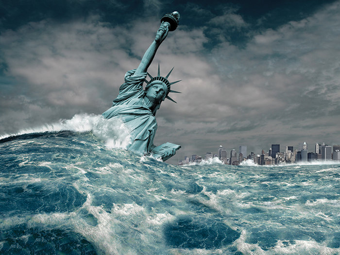

Black Swan: Mega-Tsunami
A Mega-Tsunami Is Coming; Can the East Coast Even Prepare?
Could a tsunami destroy everything from Boston to Miami? If it did, would we even stand a chance?
By: Autumn Demberger | July 30, 2018
Topics: August 2018 Issue | Business Interruption | Catastrophe | Claims | Climate Change | Crisis Management | Critical Risks | Global Risk | Property | Supply Chain | Uninsurable Risks


082018_BlackSwan_1_lead-700x525.jpg

Scenario: La Palma earned the nickname “the beautiful island” — white sand beaches highlighted by black volcanic soil. An endless night sky filled with stars as far as the eye can see.
But beauty here is only skin deep.

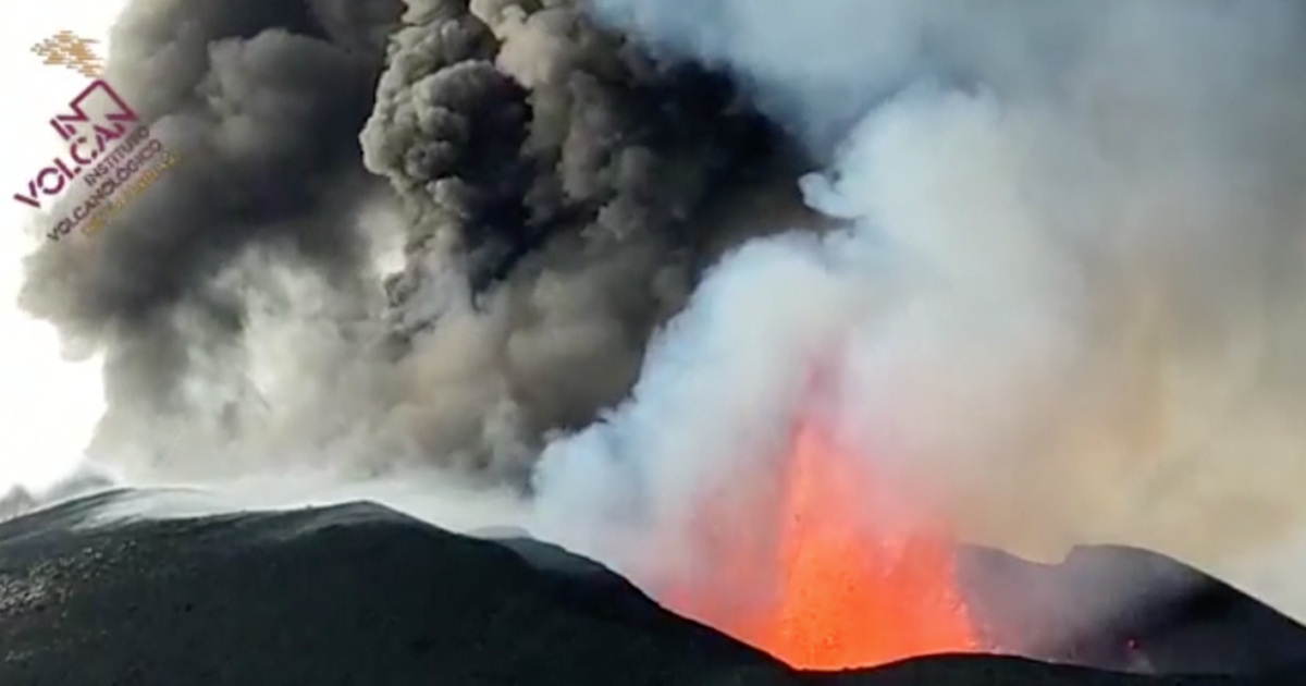
Nestled on the western side of La Palma sits the Cumbre Vieja volcano, like a pot of water waiting to boil over. Its last big eruption was more than 50 years ago, but everyone knows it’s only a matter of time before it unleashes the beast inside.
It starts with tremors. Glasses rattle on kitchen tables while picture frames skew left and right. Tourists to La Palma brush it off, calling the jelly feeling “sea legs” — they are, after all, on an island.

But the locals know better and they hold their breath. When it does happen, the ash and lava spill out of the volcano’s mouth like a giant sigh. No one could have predicted what happens next.

The western side of the volcano cracks and splits; the steam builds up inside and pushes against the volcano’s walls. The pressure is too much; the entire western flank breaks off, the Atlantic Ocean eagerly swallowing every rock, stone and pebble as they freefall into its deep blue depths. The earth rumbles and the water begins to slosh around as its calm ebb and flow turns into frenzied splashing and crashing.

The waves grow. And they grow and they grow. To the naked eye, it looks like the heavens unleashed a curtain made of water — somehow the volcano’s landslide has produced a tsunami that reaches the sky.
Azbee-National-Bronze-250x400.png

And this mega-tsunami moves fast.
All 3,000 feet of water roars as it barrels away from La Palma’s coast toward the United States. As the most western island of the Canary Islands, La Palma sits eight to 10 hours away from the eastern shore by plane. It’s the one piece of good news: Residents have a window of time to evacuate.

But chaos breeds chaos, and soon the highways are clogged with cars, frightened families from Boston to Miami trying to flee inland. A final silver lining: The wave decreases as it sojourns across the Atlantic from a staggering 3,000 to a mere 160 feet.
The wave touches down, flowing onto beaches and flooding bays. Coastal buildings don’t stand a chance; water rushes inland 10 miles along the entire eastern seaboard. Homes are destroyed, countless hotels crumble under the force. Chemical plants that once churned out product by the oceanside spill their toxic waste into the sea.

Beaches up and down the coast account for billions of dollars in tourism revenue each summer. It looks like vacationers might not be able to return for decades thanks to the amount of oils and solvents released.

On top of that, the East Coast is home to 29 percent of the U.S. population. Now they are displaced — their homes destroyed, their cities flooded. Not everyone made it out in time.

It’s not the end of the world, but it very much feels like it.
Analysis: La Palma’s mega-tsunami is a disaster, no doubt. And — scarily enough — it’s not impossible.
In 1949, the Cumbre Vieja volcano erupted along the coast of La Palma and caused an earthquake that created a mile-long fissure on its east side.

The force of the fissure then caused the volcano’s west side to slip six feet into the Atlantic Ocean. It has since remained in this position, its estimated 1.5 trillion metric tons waiting like a ticking time bomb.

Researcher and scientist Steven Ward, now a research geophysicist at the Institute of Geophysics and Planetary Physics, UC Santa Cruz, and Simon Day, a senior research associate at the Institute for Risk & Disaster Reduction, University College London, first quantified the features of the La Palma mega-tsunami.
They looked at the geological structure of the volcano and created simulations of the event, which can be seen on Ward’s YouTube channel.

If circumstances align and the volcano erupts powerfully enough, the western half of the volcano could fall into the ocean and create this mega-tsunami scenario in full, the research concluded.
“La Palma is a volcanic island,” said Ward. “It’s built up from ash and lava that pushed out layers like a stack of shingles on a sloping roof. Sometimes, volcano sides become unstable and like that stack of shingles, part of the pile slides off. It’s a common thing [to have] huge pieces of debris fall off.”

“The unusual structural evolution of the volcano, revealed by changes in the distribution of eruption sites over its surface since about 10,000 years ago, could best be explained by the progressive development of a landslide surface under that western flank and consequent weakening,” added Day.
“Satellite radar data has shown that a large section of the west flank is continuing to move very slowly … despite the fact that it is not being pushed by magma rising to the surface within the volcano,” he said.

“La Palma has a lot of water in it,” Ward explained. “The thinking is that in some future eruption, hot magma will reach this water, turn it into steam and the steam will split the mountain.”


A landslide of this scale could send out a mega-tsunami-sized wave. Ward said the hard part is predicting if, or when, the landm
the landmass will actually slide into the Atlantic.
Such an event won’t likely come out of the blue, he said. There will be a buildup of volcanic and tectonic activity beforehand that will aid researchers in forecasting a potential disaster.
In fact, earlier this year, residents of the island feared the worst as La Palma encountered more than 40 mini-earthquakes within a 48-hour period. Large tremors stemming from Cumbre Vieja followed soon after, though the volcano never erupted.
A Catastrophe Too Big to Predict
A mega-tsunami is hard to predict and prepare for. On a smaller scale, tsunamis themselves are rare enough events.
“Usually you have significant property and clean-up — and BI damage or costs,” said Ed Mazman, president of property, Ironshore.
Specifically, Mazman said, coastal businesses are most at risk: “A lot of that is hospitality, hotels, resorts. This is a tremendous event, uncontrollable exposures.”
There are ways to prepare for a “typical” tsunami, but when it comes to an event like this and the size of the potential wave, “I don’t think we could really protect against it,” he said.
“It’s like a tornado. You could have a structure prepped for a tornado, but if it’s in the way of a CAT 5, that tornado’s going to win.” — Ed Mazman, president of property, Ironshore
“Firms are thinking about life safety over property damage. You can’t really protect property. If it’s in the path, if it’s close enough — it’s like a tornado. You could have a structure prepped for a tornado, but if it’s in the way of a CAT 5, that tornado’s going to win,” Mazman said.

The best example to look at in terms of damage done is Superstorm Sandy, which hit the East Coast in October 2012.
While Sandy gives an idea of the extent of damage to expect, a mega-tsunami still differs in one glaring way: the area impacted. This is not just one city bearing the brunt of the damage; anything in between Boston and Miami could feel the wrath of the tsunami.
“Every scenario [already modeled] seems to be limited to one geographic area, like a large metropolitan area. If a CAT 5 hurricane were to hit Miami, it’s $150 to $200 billion. This [mega-tsunami] would be at least 10 times that,” said Mazman.
The good news: There’s a window of time for those on the East Coast to evacuate before a mega-tsunami even touches down on land.
“A tsunami travels as fast as a jet airplane, 400 to 500 miles per hour. But the ocean’s pretty big. From La Palma to the East Coast, it would take eight to 10 hours for a mega-tsunami to get there,” Ward explained.
 
Top