Electroverse
Articles Crop Loss Extreme Weather
California’s Quiet Wildfire Season; Snowfall Records Fall Across US; Monthly Low Temp Benchmarks Tumble Down Under As Rare Spring Flakes Hit Tasmania; Villages Cut Off As Heavy Snow Hits Kashmir; + Europe’s Food Prices Soar
November 16, 2022 Cap Allon
California’s Quiet Wildfire Season
California is enjoying its quietest wildfires in years, attributable, in part, to summer rain and cooler weather — natural cycles.
Fires have swept through 363,000 acres across the Golden State, which is a fraction of recent years.
The AGW Party are still peddling the fear, though: Max Molritz, a wildfire specialist with University of California Cooperative Extension, warns that if the state doesn’t see much precipitation over the next few months, it will continue to be at risk.
“The plants themselves are still under pretty extreme water stress, and they’re still potentially quite flammable, even if it’s cold,” said Moritz, which I’m sure is a frustrating message for the AGW Party to promote — wildfires aren’t linked to temperature.
This year, summer rains prevented many fires from taking hold, including ‘the Mosquito Fire’ which ignited early-September in Placer and El Dorado countries. Fear-driven climate models had predicted the fire would burn all the way to North Lake Tahoe, but then rains came to Northern California and doused the fire and drenched the surrounding vegetation.
“It could have been a pretty terrible fire season except that we had rain in mid-September,” said a
straw-clutching Michael Wara, director of the climate and energy policy program at Stanford University. That late-summer storm decreased the wildfire risk for several weeks, and was then chased by yet more precipitation in October. and now November.
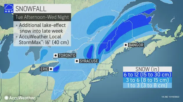
Snowfall Records Fall Across US
Broken snowfall records are mounting as a powerful Arctic Outbreak descends on the Lower 48.
Lebanon, Indiana –for example– recently received a daily snow total of 2.7 inches, its highest for the date since 1991.
A myriad of snow resorts are opening earlier than schedule, too, following historic early-season dumpings. Big Sky Resort in Montana is one such area, probably the most recent, though there are many, many others — California’s Mammoth Mountain is already enjoying one of its snowiest Novembers in decades, and we’re barely halfway through the month,
While in Wichita, Kansas, the 0.4 inches that settled Monday may not sound like a lot, but it was enough to bust a 135-year-old snowfall record, surpassing the 0.3 inches set on Nov 14, 1929 in weather books dating all the way back to 1888.
Record cold accompanied the record Wichita snow — a frigid 9F was logged on Tues, Nov 15, usurping the 10F set in 1955.
“We are starting to get into winter,” NWS meteorologist Eric Metzger helpfully pointed out, “usually we don’t get this cold this early, usually you have to wait to December,” he added, also pointing out that the cold
and snow is forecast to hang around through the weekend, at least.
As discussed in previous articles, the vast majority of the CONUS is in the midst of a
full-blown taste of winter:
Monthly Low Temp Benchmarks Tumble Down Under As Rare Spring Flakes Clip Tasmania
Following what was a colder-than-average winter –record-breaking cold for the likes of Brisbane– spring is continuing that cooling trend. Even with summer around the corner, blasts of polar cold are still hitting the Australian continent.
A string of
monthly low temperature records have been broken this week, slain in some cases. The out-of-season freeze has really been quite something, felling ‘November lowest maximum temperatures’ in the likes Liawenee, Portland, Grove, Tunnack, Breakwater and Strathalbyn, to name just six.
Also noteworthy, of those six, three broke records set earlier
this month, serving as further evidence that Australia’s chills are persistent, not a one-off freeze events that the AGW Party can pass off as ‘a freak weather event’.

A handful of Australia’s busted
monthly low temperature records.
The accompanying mid-November
snow has also been noteworthy.
Snow settled at Vinces Saddle on the Huon Highway, Tasmania on Tuesday — about 200 meters (650 feet) lower than the warm-mongering BoM had initially forecast. Parts of kunanyi/Mt Wellington also experienced substantial spring snowfall.
Bureau of Meteorology duty forecaster Michael Conway said more snow is possible in elevated parts, including the south and south-east, lower east coast, southern midlands and central plateau.
According to the BoM, another record-challenging cold front is expected next week.
The GFS is in agreement:

GFS 2m Temperature Anomalies (C) Nov 16 – Nov 22 [
tropicaltidbits.com].
Villages Cut Off As Heavy Snow Hits Kashmir
Major highways are closed and many towns and villages have been cut-off due to heavy overnight snowfall in Jammu and Kashmir, India. Authorities have also closed schools due to the early hit of winter.
The infamous Mughal Road, an alternative link between the Jammu region and Kashmir’s Shopian district, was closed due to heavy snow at Pir Ki Gali and the surrounding area. The Bandipora-Gurez road was also shut.
Early season snowfall has been reported in many locales, including Handwara, Kralpora, Pazipora and Tangdhar, Kupwara, Tangmarg, and Khansahib–often times far earlier than normal, according to local officials.

Heavy snow in Kashmir cuts off many remote districts.
The recent storm delivered 6 inches of snow to Gulmarg, more than a foot to Gurez and Machil, and 2 feet to the Koksar district, with the latter cut off from the rest of the state after accumulations blocked the Atal Tunnel on the Manali-Leh highway.
The heavy snowfall has resulted in many remote towns and villages being completely cut off from the outside world.
Not helping matters, the 270km-long Jammu-Srinagar highway –the only
all-weather road linking Kashmir with the rest of the country– has been also closed due to feet of accumulating snow.

Snow-clad village after heavy snowfall hit Lahaul and Spiti this week [Jai Kumar].

The upper Manali area covered in snowfall on Monday.
Europe’s Food Prices Soar
Rising energy prices and rolling blackouts are bad enough, but it’s food insecurity, i.e. rising costs and shortages, that will break the camels back, the straw that sees the masses willingly walk into this looming technocratic and totalitarian future.
Europe is having a torrid time of it; all self-inflicted, but still, the people didn’t vote for this demolition.
And this is a message I want those in the future, looking back on this time, to know:
“Why did they believe such claptrap about the climate etc.? … Why did they willfully allow their energy and food security and ultimately their freedoms be stripped from them?”.
Well, the majority of us knew full-well it was nonsense, but the opposition, ‘the establishment’, had gained a monopoly on the ‘truth’ and it became increasingly difficult for the average Joe to navigate the mire of obfuscation and deception, to find which way was up.
The elites bought governments, the media and the education systems; they took the farmland and the water rights from us; they told us that unless we accepted stark reductions in living standards life on planet Earth would cease to exist. And, frustratingly, a noisy minority fell for it, pushed this narrative on others, and virtue-signaled
us all into socialism, digital slavery and destruction.
That’s what happened. Forget the history books. We had no say in their writing. The majority of us weren’t stupid or gullible, we were simply overpowered, outplayed. Most of us knew
they were lying, and
they knew we knew
they were lying, yet
they still successfully pushed through their society-wrecking policies via their planted politicians, journalists and brainwashed activists, and they took us down.
Market prices of fresh produce have shot to record highs in Bulgaria, with tomatoes up by 19%, cucumbers by 6.1%, green peppers up by 10.1%, potatoes by 4.5%, and apples by 4%. While in Spain, record rises were posted last month, keeping the cost of living crippling high. Spain’s overall food prices climbed 15.4% from a year earlier, the biggest increase since the statistical series began, with the cost of fresh vegetables jumping by 25.7%, eggs up 25.5%, milk up 25% and grains up 22.1%.
Food prices are rising globally, of course, not just in Europe.
This is unsustainable, but this is also the point.
Rising food prices will be the story throughout 2023 as the fertilizer and herbicide/pesticide ‘shortages’ impact yields and as farmland intentionally sits barren in the name of ‘saving the planet from the ravages of CO2’.
Then the rationing will come, quickly followed by the realization that those empty shelves aren’t going to be restocked. Next comes blind panic, in tandem with social unrest, riots and then, finally, and only at the pit of despair,
they will implement the new monetary system, i.e. CBDCs and Digital IDs. This roll-out will be sold as our savior, but in actual fact it will strip us of the few freedoms we have left. These tools will enslave us indefinitely, digitally, and the unprepared will have no choice but to comply. By that point, however, the masses will likely be thankful for them — they have long been trained to pick convenience over freedom.
Related
Journalists ‘Instructed’ To Attribute “Any Extreme Heat To Human Caused Climate Change”; Cold Records Fall In Texas And Guam; + First Time Since 1941 That The Atlantic Has Had No Named StormsSeptember 1, 2022In "Articles"
It Is Climate Zealotry, Rather Than Climate Change, That Is Destroying The WorldSeptember 7, 2022In "Articles"
No Scientific Consensus On A Warming Arctic And Extreme WeatherNovember 3, 2022In "Articles"


 ️ Historic snowstorm is now underway. Credit :


