Volcano Update 2 - Additional vents opening -Volcano on La Palma island in the Canary Islands has erupted

Lilbitsnana

On TB every waking moment
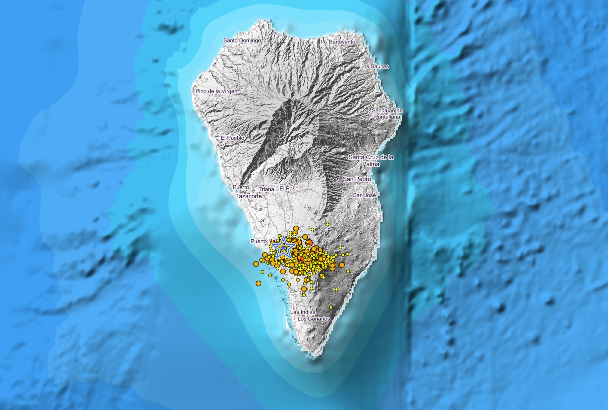
Fire locations progressing east from the main cluster. There is a line forming that looks to cut across the island. New vents forming east, I'd guess.

What are you calling the "line"?

There are roads (the tan/off-white dotted lines) on that map. The lava flow has gone across the main North/South road on that side of island. I don't know where it is located, but apparently the road has a tunnel and it was overrun with lava several days or weeks ago.

From what I can tell, the red and yellow are showing fires/lava/steam/ash temps.
 
Last edited:

TheSearcher

Are you sure about that?
What are you calling the "line"?

There are roads (the tan/off-white dotted lines) on that map. The lava flow has gone across the main North/South road on that side of island. I don't know where it is located, but apparently the road has a tunnel and it was overrun with lava several days or weeks ago.

From what I can tell, the red and yellow are showing fires/lava/steam/ash temps.

Those red/orange boxes are fire indicators, and up until recently it was in that big cluster to the west. The figure shows a couple of fires springing up due east, and in my mind that projects a line.
 

Lilbitsnana

On TB every waking moment
Those red/orange boxes are fire indicators, and up until recently it was in that big cluster to the west. The figure shows a couple of fires springing up due east, and in my mind that projects a line.

it is mostly lava, some fires as a building burned
the two squares on the right could be lava or steam.
That site had only been emitting steam, but in last two or three days was sometimes a small flow of lava as well


from the site:

  • Red squares show satellite derived thermal anomalies which may be from fire, hot smoke, agriculture or other sources.
  • The size of the red squares represent an approximate 1km x 1km pixel for MODIS data and 375m x 375m pixel for VIIRS.
  • Detected activity could be a small, intense fire or a fire burning over a broader area within the pixel. It does not mean the entire square is entirely on fire.
    What does a fire detection mean on the ground?
  • The spatial resolution, satellite view geometry and detection confidence available as attributes for each detection/hotspot should be considered when using these data.
  • Due to their relatively coarse spatial resolution and technical considerations inherent to satellite-derived data, they should be applied carefully at relatively local scales.
 

Lilbitsnana

On TB every waking moment

I never saw what you are talking about. It looks a lot like it has before.
The top cone has widened a bit today, but still multiple vents flowing.

If you had noted the time on the clock at bottom left of the screen it would help. (clock shows La Palma time)
This is same view other than the inset at top of the link that I posted in 1007.

this one is actually over a minute behind from live link in 1007. They had a problem with one of the streams a day or two ago, so now this one runs "behind" because they are relaying it or something. It was explained at the time in the chat, but don't remember exact details.

chats are different between afartv feed 1 and 2, so different comments.
 

Pinecone

Has No Life - Lives on TB
I never saw what you are talking about. It looks a lot like it has before.
The top cone has widened a bit today, but still multiple vents flowing.

If you had noted the time on the clock at bottom left of the screen it would help. (clock shows La Palma time)
This is same view other than the inset at top of the link that I posted in 1007.

this one is actually over a minute behind from live link in 1007. They had a problem with one of the streams a day or two ago, so now this one runs "behind" because they are relaying it or something. It was explained at the time in the chat, but don't remember exact details.

chats are different between afartv feed 1 and 2, so different comments.
One hour ago if you run the red line at the bottom back.
 

Lilbitsnana

On TB every waking moment
One hour ago if you run the red line at the bottom back.

I've ran it back multiple times. Without knowing the exact timestamp on the clock, I can't tell what you are talking about. I didn't see anything unusual.

There is a fixed in place red block/rectangle at bottom left. It says "Day 35 Oct 23 and then a time", that is the best way to find things.
 

Lilbitsnana

On TB every waking moment
There are two new lava streams this morning; one of them is said to be very fast moving.

There were some more partial cone collapses over last few hours.


people have named some of the vents and cones, I am not sure of all the different names.

snippets from chat on afarTV feed1:

"The lowering of the lava from the collapse is likely causing the higher cones to experience some internal slip so more black smoke as the ejecta slips back in"


"There's two new lava streams: from Sidney but southwestern, and lower down between sid and mama to the south"
 
Last edited:

Lilbitsnana

On TB every waking moment
I haven't gone back in time on the livestream to check, but here is a entry from chat (feed 1) that gives the time of a couple of the collapses.

Clock on very bottom left will give the time, all time is shown in La Palma time. (timestamp of chat is showing in CDT, clock at bottom of livestream is always showing La Palma time, it is currently 12:21 PM. So entry below is talking about 7:41 AM and 9:30 AM island time which is also the clock time period to go back to )

6:08 AM TooMass@Manny Mayer check 07:41:00 when it partly collapsed and due to that lower vent spilled out all the lava. at 09:30:00 you can see an overflow from Sydneys partly collapsed north flank

View: https://www.youtube.com/watch?v=XLeYZY6VVAw
 
Last edited:

Lilbitsnana

On TB every waking moment
There was a 4.3 EQ this morning (2:28 AM Central time; 8:28 AM la Palma time)

Saturday, October 23, 2021 11:23 GMT (47 earthquakes)
Oct 23, 2021 8:28 am (GMT +1) (Oct 23, 2021 07:28 GMT)
4 hours ago
4.3
36 km
La Palma Island, 14 km southeast of Los Llanos de Aridane, Spain
 

Lilbitsnana

On TB every waking moment
hmm, got distracted and hadn't checked EQs for a while.

This 4.1 quake was much farther North and East than the others, this one was near the coast on the top third of the island (SE of Candelaria and NNW of Santa Cruz de la palma). It looks like it should actually be in/on one of the other two volcano plumes. The ones that feed Cumbre Nuevo or Taburiente. hmmm

Thursday, October 21, 2021 04:03 GMT (17 earthquakes)
Oct 21, 2021 3:14 am (GMT +1) (Oct 21, 2021 02:14 GMT)
2 hours 1 minutes ago
4.1
40 km
La Palma Island, Canary Islands, Spain
I FELT IT - 6 reports

Since this all began, it is Cumbre Vieja that has been active with multiple vents.

I am starting to become more and more convinced that Cumbre Nuevo is starting to become active as well.

More and more of the EQs are located in places that would reflect the Nuevo lava tubes are about to be or are being fed lava.

Things are interesting for sure.
 

Lilbitsnana

On TB every waking moment
another timeframe for one of the collapses several hours ago. (again, chat timestamp is current CDT, the video timestamp is la Palma time, so 7:39 AM la palma time and 8:30 and 8:54 AM la Palma time. It is currently 2:23 PM la Palma time) Any livestream that shows la palma time, but I look at afarTV feeds 1 or 2 usually.

7:59 AM Charlie Desperado @Wen Hop if you go back and have a look.. the Baby vent violently spills out at 7:39 local time.. before that Sydney is fine. Then at 8:30 through the haze you can see Syndey change. at 8:54 it splits
 

Lilbitsnana

On TB every waking moment
I haven't seen the drone video being mentioned

9:03 AM mc Maca new drone video confirms that there r 5 vents now..2 behind mama vent..there use to be 3 on the top of the cone but i guess the missing two r making a comeback now haha


this is for a brief lava flow on front lower right of current volcano view coming out of cone

from chat:
full run of the partial collapse and lava flow is from 13:58-14:14 plus

View: https://www.youtube.com/watch?v=dTTm5zXiydg
 

Lilbitsnana

On TB every waking moment
been busy, hadn't seen this

hmmm
a 4.9 unless it gets revised down later (ETA: confirmed at 4.9 after bringing it down from a 5.0)


Saturday, October 23, 2021 15:34 GMT (51 earthquakes)
Oct 23, 2021 4:34 pm (GMT +1) (Oct 23, 2021 15:34 GMT)
38 minutes ago
4.9
38 km
La Palma Island, 10.1 km south of Santa Cruz de La Palma, Spain
ETA:


Earthquake data: Mag 4.9 / 38.0 km (24 mi) depth
40 minutes ago reported felt
Oct 23, 2021 15:34 GMT, Oct 23, 2021 4:34 pm (GMT +1) local time
Lat / Lng: 28.5951 / -17.7898: La Palma Island, Canary Islands, Spain
Source: IGN
Other sources: EMSC: 4.7 / 40 km
 
Last edited:
Top