
You are using an out of date browser. It may not display this or other websites correctly.
You should upgrade or use an alternative browser.
You should upgrade or use an alternative browser.
WEATHER Severe Weather the Week of April 29th, 2024
- Thread starter packyderms_wife
- Start date
Worst tornado this evening currently in progress,
Large debris signature detected on radar.
----------------------------------------
BULLETIN - EAS ACTIVATION REQUESTED
TORNADO WARNING
NATIONAL WEATHER SERVICE NORMAN OK
944 PM CDT TUE APR 30 2024
THE NATIONAL WEATHER SERVICE IN NORMAN HAS ISSUED A
* TORNADO WARNING FOR...
SOUTH CENTRAL COMANCHE COUNTY IN SOUTHWESTERN OKLAHOMA...
WEST CENTRAL COTTON COUNTY IN SOUTHWESTERN OKLAHOMA...
EAST CENTRAL TILLMAN COUNTY IN SOUTHWESTERN OKLAHOMA...
* UNTIL 1030 PM CDT.
* AT 944 PM CDT, A CONFIRMED LARGE AND EXTREMELY DANGEROUS TORNADO
WAS LOCATED 3 MILES NORTHEAST OF HOLLISTER, MOVING EAST AT 10 MPH.
THIS IS A PARTICULARLY DANGEROUS SITUATION. TAKE COVER NOW!
HAZARD...DAMAGING TORNADO.
SOURCE...RADAR CONFIRMED TORNADO.
IMPACT...YOU ARE IN A LIFE-THREATENING SITUATION. FLYING DEBRIS
MAY BE DEADLY TO THOSE CAUGHT WITHOUT SHELTER. MOBILE
HOMES WILL BE DESTROYED. CONSIDERABLE DAMAGE TO HOMES,
BUSINESSES, AND VEHICLES IS LIKELY AND COMPLETE
DESTRUCTION IS POSSIBLE.
* LOCATIONS IMPACTED INCLUDE...
CHATTANOOGA, FAXON, HOLLISTER, AND LOVELAND.
PRECAUTIONARY/PREPAREDNESS ACTIONS...
TO REPEAT, AN EXTREMELY DANGEROUS AND POTENTIALLY DEADLY TORNADO IS
ON THE GROUND. TO PROTECT YOUR LIFE, TAKE COVER NOW! MOVE TO A STORM
SHELTER, SAFE ROOM OR AN INTERIOR ROOM ON THE LOWEST FLOOR OF A
STURDY BUILDING. AVOID WINDOWS. IF YOU ARE OUTDOORS, IN A MOBILE
HOME, OR IN A VEHICLE, MOVE TO THE CLOSEST SUBSTANTIAL SHELTER AND
PROTECT YOURSELF FROM FLYING DEBRIS.
Max Velocity is saying this is a very rare (2%) anti-cyclonic (clockwise) rotating tornado.
He says he has never seen an anti-cyclonic receive a PDS Warning.
The tornado is also almost stationary.
----------------
SEVERE WEATHER STATEMENT
NATIONAL WEATHER SERVICE NORMAN OK
1026 PM CDT TUE APR 30 2024
OKC033-141-010400-
/O.CON.KOUN.TO.W.0089.000000T0000Z-240501T0400Z/
COTTON OK-TILLMAN OK-
1026 PM CDT TUE APR 30 2024
...A TORNADO WARNING REMAINS IN EFFECT UNTIL 1100 PM CDT FOR WEST
CENTRAL COTTON AND SOUTHEASTERN TILLMAN COUNTIES...
AT 1026 PM CDT, A CONFIRMED LARGE AND EXTREMELY DANGEROUS TORNADO
WAS LOCATED ABOUT 4 MILES SOUTHEAST OF LOVELAND, AND IS NEARLY
STATIONARY OR MOVING VERY SLOWLY SOUTH.
THIS IS A PARTICULARLY DANGEROUS SITUATION. TAKE COVER NOW!
HAZARD...DAMAGING TORNADO.
SOURCE...RADAR CONFIRMED TORNADO.
IMPACT...YOU ARE IN A LIFE-THREATENING SITUATION. FLYING DEBRIS MAY
BE DEADLY TO THOSE CAUGHT WITHOUT SHELTER. MOBILE HOMES
WILL BE DESTROYED. CONSIDERABLE DAMAGE TO HOMES,
BUSINESSES, AND VEHICLES IS LIKELY AND COMPLETE DESTRUCTION
IS POSSIBLE.
LOCATIONS IMPACTED INCLUDE...
GRANDFIELD, DEVOL, AND LOVELAND.
PRECAUTIONARY/PREPAREDNESS ACTIONS...
TORNADOES ARE EXTREMELY DIFFICULT TO SEE AND CONFIRM AT NIGHT. DO NOT
WAIT TO SEE OR HEAR THE TORNADO. TAKE COVER NOW!
I've been watching storm chasers today and they have reported what they called weird stuff. (I have no idea what is normal.) A tornado which formed in a really high base and then sorta drilled a house as it hung over the storm chasers earlier today. Then the one RB reported which was anti-cyclonic.
packyderms_wife
Neither here nor there.
Max Velocity is saying this is a very rare (2%) anti-cyclonic (clockwise) rotating tornado.
He says he has never seen an anti-cyclonic receive a PDS Warning.
The tornado is also almost stationary.
----------------
SEVERE WEATHER STATEMENT
NATIONAL WEATHER SERVICE NORMAN OK
1026 PM CDT TUE APR 30 2024
OKC033-141-010400-
/O.CON.KOUN.TO.W.0089.000000T0000Z-240501T0400Z/
COTTON OK-TILLMAN OK-
1026 PM CDT TUE APR 30 2024
...A TORNADO WARNING REMAINS IN EFFECT UNTIL 1100 PM CDT FOR WEST
CENTRAL COTTON AND SOUTHEASTERN TILLMAN COUNTIES...
AT 1026 PM CDT, A CONFIRMED LARGE AND EXTREMELY DANGEROUS TORNADO
WAS LOCATED ABOUT 4 MILES SOUTHEAST OF LOVELAND, AND IS NEARLY
STATIONARY OR MOVING VERY SLOWLY SOUTH.
THIS IS A PARTICULARLY DANGEROUS SITUATION. TAKE COVER NOW!
HAZARD...DAMAGING TORNADO.
SOURCE...RADAR CONFIRMED TORNADO.
IMPACT...YOU ARE IN A LIFE-THREATENING SITUATION. FLYING DEBRIS MAY
BE DEADLY TO THOSE CAUGHT WITHOUT SHELTER. MOBILE HOMES
WILL BE DESTROYED. CONSIDERABLE DAMAGE TO HOMES,
BUSINESSES, AND VEHICLES IS LIKELY AND COMPLETE DESTRUCTION
IS POSSIBLE.
LOCATIONS IMPACTED INCLUDE...
GRANDFIELD, DEVOL, AND LOVELAND.
PRECAUTIONARY/PREPAREDNESS ACTIONS...
TORNADOES ARE EXTREMELY DIFFICULT TO SEE AND CONFIRM AT NIGHT. DO NOT
WAIT TO SEE OR HEAR THE TORNADO. TAKE COVER NOW!
Max is a baby when it comes to weather events, he’s got a whole lot more strange severe weather to see in his lifetime! I’ve got stories of some of the weird weather stuff I’ve seen in my life, ball lightning being one of them.
Last edited:
packyderms_wife
Neither here nor there.
Have you seen any videos of this yet?A traditional cyclonic tornado signature is now forming near the anti-cyclonic tornado.
A twin tornado is possible!
Meemur
Voice on the Prairie / FJB!
Yeah, I think some of the weather wonks are very young. They really should look back at the 70s in the Midwest. We had some wild weather then too, including several summers in a row of very large hail that impacted the corn harvest.
I was at an informal ("day version") of our neighborhood watch meeting. One of the LEOs told us to let them know if the storm chasers are driving too recklessly and to take video *if* we could do so safely. He said that there will be a state-wide crackdown on bad driving behaviors during storms.
They can chase, but they can't endanger the driving public while doing so.
packyderms_wife
Neither here nor there.
I see Westmoreland KS got hit hard last night!
View: https://www.youtube.com/watch?v=rNKQolIbuf4
THE MOST INSANE TORNADO VIDEO ever captured in Westmoreland, Kansas
RT 8:41 - Reed Timmer
THE MOST INSANE TORNADO VIDEO ever captured in Westmoreland, Kansas
RT 8:41 - Reed Timmer
Last edited:
packyderms_wife
Neither here nor there.
Yeah, I think some of the weather wonks are very young. They really should look back at the 70s in the Midwest. We had some wild weather then too, including several summers in a row of very large hail that impacted the corn harvest.
Every time Max declares something "rare" I have to remind myself that he's not even 30 yet. The ball lightning I saw during the flood of 1993, a whole bunch of us saw it, I was in the passenger side of a car stuck on the interstate coming out of St. Louis, traffic had come to a halt due to a helicopter crash on the river, right next to the bridge we were stuck on. To this day I'm still afraid of helicopters! The reporters on board managed to capture the ball lightning right before they crashed. No I don't think the ball lightning caused the crash, it was incredibly windy that day. The odd thing about the ball lightning was that it was partly sunny out, with a ferocious thunderstorm right behind us that was fixing to blow through.
packyderms_wife
Neither here nor there.
RT 8:44 - Ryan Hall y'all
In this video we are talking about the upcoming 2024 hurricane season & how it could be very active.

College of DuPage Meteorology
Severe Weather and Flash Flood Warnings
Note: This page will reload every 2 minutes. Warnings are listed with the most recent first.
Click on the station ID to bring up list of recent severe weather statements.
TORNADO WARNING FAIRBANKS AK - PAFG 1145 AM AKDT WED MAY 1 2024
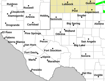
SVR T-STORM WARNING MIDLAND/ODESSA TX - KMAF 241 PM CDT WED MAY 1 2024
SVR T-STORM WARNING MIDLAND/ODESSA TX - KMAF 234 PM CDT WED MAY 1 2024
TORNADO WARNING FAIRBANKS AK - PAFG 1121 AM AKDT WED MAY 1 2024
TORNADO WARNING FAIRBANKS AK - PAFG 1116 AM AKDT WED MAY 1 2024
TORNADO WARNING FAIRBANKS AK - PAFG 1055 AM AKDT WED MAY 1 2024
Why does Fairbanks, AK have a test for tornado warnings? OH, I went and looked. They are pretty rare. Never knew they had them up that far north! I learn something new every day.
College of DuPage Meteorology
Severe Weather and Flash Flood Warnings
Note: This page will reload every 2 minutes. Warnings are listed with the most recent first.
Click on the station ID to bring up list of recent severe weather statements.
TORNADO WARNING FAIRBANKS AK - PAFG 1145 AM AKDT WED MAY 1 2024
SVR T-STORM WARNING MIDLAND/ODESSA TX - KMAF 241 PM CDT WED MAY 1 2024
SVR T-STORM WARNING MIDLAND/ODESSA TX - KMAF 234 PM CDT WED MAY 1 2024
TORNADO WARNING FAIRBANKS AK - PAFG 1121 AM AKDT WED MAY 1 2024
TORNADO WARNING FAIRBANKS AK - PAFG 1116 AM AKDT WED MAY 1 2024
TORNADO WARNING FAIRBANKS AK - PAFG 1055 AM AKDT WED MAY 1 2024
packyderms_wife
Neither here nor there.
Texas
Tornado Warning
TXC371-012115-
/O.NEW.KMAF.TO.W.0001.240501T2037Z-240501T2115Z/
BULLETIN - EAS ACTIVATION REQUESTED
Tornado Warning
National Weather Service Midland/Odessa TX
337 PM CDT Wed May 1 2024
The National Weather Service in Midland has issued a
* Tornado Warning for...
Central Pecos County in southwestern Texas...
* Until 415 PM CDT.
* At 336 PM CDT, a severe thunderstorm capable of producing a tornado
was located 17 miles south of Fort Stockton, moving east at 15 mph.
HAZARD...Tornado and ping pong ball size hail.
SOURCE...Radar indicated rotation.
IMPACT...Flying debris will be dangerous to those caught without
shelter. Mobile homes will be damaged or destroyed.
Damage to roofs, windows, and vehicles will occur. Tree
damage is likely.
* This tornadic thunderstorm will remain over mainly rural areas of
central Pecos County.
PRECAUTIONARY/PREPAREDNESS ACTIONS...
TAKE COVER NOW! Move to a basement or an interior room on the lowest
floor of a sturdy building. Avoid windows. If you are outdoors, in a
mobile home, or in a vehicle, move to the closest substantial shelter
and protect yourself from flying debris.
Heavy rainfall may hide this tornado. Do not wait to see or hear the
tornado. TAKE COVER NOW!
&&
LAT...LON 3062 10289 3071 10289 3080 10251 3054 10248
TIME...MOT...LOC 2036Z 265DEG 14KT 3066 10281
TORNADO...RADAR INDICATED
MAX HAIL SIZE...1.50 IN
$$
91
Tornado Warning
TXC371-012115-
/O.NEW.KMAF.TO.W.0001.240501T2037Z-240501T2115Z/
BULLETIN - EAS ACTIVATION REQUESTED
Tornado Warning
National Weather Service Midland/Odessa TX
337 PM CDT Wed May 1 2024
The National Weather Service in Midland has issued a
* Tornado Warning for...
Central Pecos County in southwestern Texas...
* Until 415 PM CDT.
* At 336 PM CDT, a severe thunderstorm capable of producing a tornado
was located 17 miles south of Fort Stockton, moving east at 15 mph.
HAZARD...Tornado and ping pong ball size hail.
SOURCE...Radar indicated rotation.
IMPACT...Flying debris will be dangerous to those caught without
shelter. Mobile homes will be damaged or destroyed.
Damage to roofs, windows, and vehicles will occur. Tree
damage is likely.
* This tornadic thunderstorm will remain over mainly rural areas of
central Pecos County.
PRECAUTIONARY/PREPAREDNESS ACTIONS...
TAKE COVER NOW! Move to a basement or an interior room on the lowest
floor of a sturdy building. Avoid windows. If you are outdoors, in a
mobile home, or in a vehicle, move to the closest substantial shelter
and protect yourself from flying debris.
Heavy rainfall may hide this tornado. Do not wait to see or hear the
tornado. TAKE COVER NOW!
&&
LAT...LON 3062 10289 3071 10289 3080 10251 3054 10248
TIME...MOT...LOC 2036Z 265DEG 14KT 3066 10281
TORNADO...RADAR INDICATED
MAX HAIL SIZE...1.50 IN
$$
91
packyderms_wife
Neither here nor there.
packyderms_wife
Neither here nor there.
South Texas

Meemur
Voice on the Prairie / FJB!
And then there are also extremely rare January tornadoes, such as in Jan. 3, 2023 in Illinois: January 3, 2023 Tornado EventWhy does Fairbanks, AK have a test for tornado warnings? OH, I went and looked. They are pretty rare. Never knew they had them up that far north! I learn something new every day.
When the conditions are right, geography or time of year doesn't matter.
SouthernBreeze
Has No Life - Lives on TB
And then there are also extremely rare January tornadoes, such as in Jan. 3, 2023 in Illinois: January 3, 2023 Tornado Event
When the conditions are right, geography or time of year doesn't matter.
You're right, Meemur. Mississippi has seen tornadoes in every month of the year over the years. I remember a few years ago, a tornado touched down in Pontotoc, MS and wiped the town almost clean. Happened on Christmas Day.
packyderms_wife
Neither here nor there.
Tornado Warning
TXC195-233-357-393-012245-
/O.NEW.KAMA.TO.W.0007.240501T2155Z-240501T2245Z/
BULLETIN - EAS ACTIVATION REQUESTED
Tornado Warning
National Weather Service Amarillo TX
455 PM CDT Wed May 1 2024
The National Weather Service in Amarillo has issued a
* Tornado Warning for...
Northeastern Hutchinson County in the Panhandle of Texas...
Southeastern Hansford County in the Panhandle of Texas...
Northern Roberts County in the Panhandle of Texas...
Southwestern Ochiltree County in the Panhandle of Texas...
* Until 545 PM CDT.
* At 454 PM CDT, a severe thunderstorm capable of producing a tornado
was located 12 miles south of Spearman, moving northeast at 25 mph.
HAZARD...Tornado and hail up to two inches in diameter.
SOURCE...Weather spotters reported a rotating wall cloud.
IMPACT...Flying debris will be dangerous to those caught without
shelter. Mobile homes will be damaged or destroyed.
Damage to roofs, windows, and vehicles will occur. Tree
damage is likely.
* This tornadic thunderstorm will remain over mainly rural areas of
northeastern Hutchinson, southeastern Hansford, northern Roberts
and southwestern Ochiltree Counties.
PRECAUTIONARY/PREPAREDNESS ACTIONS...
TAKE COVER NOW! Move to a basement or an interior room on the lowest
floor of a sturdy building. Avoid windows. If you are outdoors, in a
mobile home, or in a vehicle, move to the closest substantial shelter
and protect yourself from flying debris.
&&
LAT...LON 3595 10120 3603 10126 3632 10087 3595 10060
TIME...MOT...LOC 2154Z 237DEG 21KT 3602 10115
TORNADO...RADAR INDICATED
MAX HAIL SIZE...2.00 IN
$$
COR
packyderms_wife
Neither here nor there.
packyderms_wife
Neither here nor there.
Tornado Warning
TXC045-191-020130-
/O.NEW.KLUB.TO.W.0002.240502T0058Z-240502T0130Z/
BULLETIN - EAS ACTIVATION REQUESTED
Tornado Warning
National Weather Service Lubbock TX
758 PM CDT Wed May 1 2024
The National Weather Service in Lubbock Texas has issued a
* Tornado Warning for...
Southwestern Hall County in the Panhandle of Texas...
Southeastern Briscoe County in the Panhandle of Texas...
* Until 830 PM CDT.
* At 757 PM CDT, a confirmed tornado was located 4 miles northeast of
Turkey, moving northeast at 10 mph.
HAZARD...Damaging tornado and ping pong ball size hail.
SOURCE...Public confirmed tornado.
IMPACT...Flying debris will be dangerous to those caught without
shelter. Mobile homes will be damaged or destroyed.
Damage to roofs, windows, and vehicles will occur. Tree
damage is likely.
* This tornadic thunderstorm will remain over mainly rural areas of
southwestern Hall and southeastern Briscoe Counties.
PRECAUTIONARY/PREPAREDNESS ACTIONS...
To repeat, a tornado is on the ground. TAKE COVER NOW! Move to a
basement or an interior room on the lowest floor of a sturdy
building. Avoid windows. If you are outdoors, in a mobile home, or in
a vehicle, move to the closest substantial shelter and protect
yourself from flying debris.
&&
LAT...LON 3463 10077 3438 10062 3431 10101 3431 10102
3441 10114
TIME...MOT...LOC 0057Z 246DEG 8KT 3442 10082
TORNADO...OBSERVED
MAX HAIL SIZE...1.50 IN
$$
12

Four large tornado outbreaks occurred during the month, producing 86, 35, 45, and at least 123 tornadoes, respectively, along with some isolated activity on other days, including a rare tornado in Alaska during the middle of the month. The month was, therefore, much above average with 297 tornadoes, the second most on record in April behind the extraordinarily active April 2011.

 en.wikipedia.org
List of United States tornadoes in April 2024 - Wikipedia
Last edited:

pauldingbabe
The Great Cat
packyderms_wife
Neither here nor there.
RT 7:52 - Ryan Hall y'all xtra
In this video we are talking about even more severe weather outbreaks in the near future…
Great
Im already getting webbed feets.
Im already getting webbed feets.
packyderms_wife
Neither here nor there.

US National Weather Service Des Moines Iowa
trodosSpen6mi0t0gag01llu544776f4u5177glg100hl0mg6m17agg7928t ·Thursday 5-2-2024 - 130 PM
Numerous reports of water over some roads in especially rural portions of the counties included in this flash flood warning. Avoid walking or driving through flood waters! Turn around, don't drown!
packyderms_wife
Neither here nor there.
May 2nd, 2024 and I have the furnace on.
packyderms_wife
Neither here nor there.
Tornado Warning
Severe Weather Statement
National Weather Service Springfield MO
205 PM CDT Thu May 2 2024
MOC011-097-021915-
/O.CON.KSGF.TO.W.0024.000000T0000Z-240502T1915Z/
Barton MO-Jasper MO-
205 PM CDT Thu May 2 2024
...A TORNADO WARNING REMAINS IN EFFECT UNTIL 215 PM CDT FOR
SOUTHWESTERN BARTON AND NORTHWESTERN JASPER COUNTIES...
At 205 PM CDT, a severe thunderstorm capable of producing a tornado
was located near Purcell, or 12 miles northwest of Carthage, moving
northeast at 25 mph.
HAZARD...Tornado.
SOURCE...Radar indicated rotation.
IMPACT...Flying debris will be dangerous to those caught without
shelter. Mobile homes will be damaged or destroyed. Damage
to roofs, windows, and vehicles will occur. Tree damage is
likely.
Locations impacted include...
Nashville.
PRECAUTIONARY/PREPAREDNESS ACTIONS...
TAKE COVER NOW! Move to a basement or an interior room on the lowest
floor of a sturdy building. Avoid windows. If you are outdoors, in a
mobile home, or in a vehicle, move to the closest substantial shelter
and protect yourself from flying debris.
&&
LAT...LON 3724 9447 3725 9452 3744 9450 3736 9433
TIME...MOT...LOC 1905Z 204DEG 20KT 3728 9448
TORNADO...RADAR INDICATED
MAX HAIL SIZE...<.75 IN
$$
Didio
packyderms_wife
Neither here nor there.

Missouri
packyderms_wife
Neither here nor there.
packyderms_wife
Neither here nor there.

jward
passin' thru
Mario Nawfal
@MarioNawfal
BREAKING: MASSIVE TORNADO IN HEART OF TEXAS
Freddy McKinney captured a harrowing scene south of Hawley, Texas, where multiple residents, including a little child who was injured, fled their destroyed home following a devastating tornado.
Source: @AZ_Intel_ , @FreddyMcKinneyR
View: https://twitter.com/MarioNawfal/status/1786197625689055375

Vegas321
Live free and survive
jwad, not a slight against you. But I think this video of Freddy's stream should be taken down.Mario Nawfal
@MarioNawfal
BREAKING: MASSIVE TORNADO IN HEART OF TEXAS
Freddy McKinney captured a harrowing scene south of Hawley, Texas, where multiple residents, including a little child who was injured, fled their destroyed home following a devastating tornado.
Source: @AZ_Intel_ , @FreddyMcKinneyR
View: https://twitter.com/MarioNawfal/status/1786197625689055375
There was a child who was seriously injured captured on video.
Just for respect of this being a juvenile.
Prayers for that child and the family. Prayers for Freddy. He is very shaken by this.