
You are using an out of date browser. It may not display this or other websites correctly.
You should upgrade or use an alternative browser.
You should upgrade or use an alternative browser.
WEATHER Severe Weather the Week of April 29th, 2024
- Thread starter packyderms_wife
- Start date

packyderms_wife
Neither here nor there.
Current Map | U.S. Drought Monitor.
US Drought Report, it's an interactive map.

 www.fireweatheravalanche.org
Wildfire map... never thought I'd be posting this one weekly.
www.fireweatheravalanche.org
Wildfire map... never thought I'd be posting this one weekly. 

 www.star.nesdis.noaa.gov
GOES Sat imagery... you can select different filter views, for dust, smoke, ash, etc
www.star.nesdis.noaa.gov
GOES Sat imagery... you can select different filter views, for dust, smoke, ash, etc
US Drought Report, it's an interactive map.
FWAC Wildfire Map - Current Wildfires, Forest Fires, and Lightning Strikes near you | Fire, Weather & Avalanche Center
Interactive real-time wildfire map for the United States, including California, Oregon, Washington, Idaho, Arizona, and others. See current wildfires and wildfire perimeters near you using the Fire, Weather & Avalanche Center Wildfire Map.
GOES Imagery Viewer - NOAA / NESDIS / STAR
Near real-time publication of GOES-East and GOES-West images from NOAA/NESDIS/STAR
packyderms_wife
Neither here nor there.
Here we go again!
Severe Weather Statement
National Weather Service Fort Worth TX
311 PM CDT Sun Apr 28 2024
TXC145-331-395-282045-
/O.CON.KFWD.TO.W.0021.000000T0000Z-240428T2045Z/
Robertson TX-Milam TX-Falls TX-
311 PM CDT Sun Apr 28 2024
...A TORNADO WARNING REMAINS IN EFFECT UNTIL 345 PM CDT FOR WEST
CENTRAL ROBERTSON...NORTHEASTERN MILAM AND SOUTHEASTERN FALLS
COUNTIES...
At 311 PM CDT, a confirmed tornado was located near Rosebud, or 16
miles north of Cameron, moving northeast at 25 mph.
HAZARD...Damaging tornado and half dollar size hail.
SOURCE...Law enforcement confirmed tornado.
IMPACT...Flying debris will be dangerous to those caught without
shelter. Mobile homes will be damaged or destroyed. Damage
to roofs, windows, and vehicles will occur. Tree damage is
likely.
Locations impacted include...
Rosebud, Wilderville, Highbank, Pleasant Grove, Baileyville, Reagan,
and Cedar Springs.
PRECAUTIONARY/PREPAREDNESS ACTIONS...
Heavy rainfall may hide this tornado. Do not wait to see or hear the
tornado. TAKE COVER NOW!
&&
LAT...LON 3098 9693 3110 9700 3128 9682 3106 9663
TIME...MOT...LOC 2011Z 233DEG 21KT 3107 9688
TORNADO...OBSERVED
MAX HAIL SIZE...1.25 IN
$$
Dunn
packyderms_wife
Neither here nor there.
Severe Weather Statement
National Weather Service Fort Worth TX
306 PM CDT Sun Apr 28 2024
TXC161-293-282045-
/O.CON.KFWD.TO.W.0020.000000T0000Z-240428T2045Z/
Freestone TX-Limestone TX-
306 PM CDT Sun Apr 28 2024
...A TORNADO WARNING REMAINS IN EFFECT UNTIL 345 PM CDT FOR
SOUTHWESTERN FREESTONE AND SOUTHEASTERN LIMESTONE COUNTIES...
At 305 PM CDT, a severe thunderstorm capable of producing a tornado
was located near Groesbeck, moving northeast at 30 mph.
HAZARD...Tornado and quarter size hail.
SOURCE...Radar indicated rotation.
IMPACT...Flying debris will be dangerous to those caught without
shelter. Mobile homes will be damaged or destroyed. Damage
to roofs, windows, and vehicles will occur. Tree damage is
likely.
This dangerous storm will be near...
Lake Limestone around 310 PM CDT.
Teague around 320 PM CDT.
Fairfield around 335 PM CDT.
Other locations impacted by this tornadic thunderstorm include
Farrar, Fallon, Dew, Box Church, Donie, Freestone, Lanely, and Cotton
Gin.
PRECAUTIONARY/PREPAREDNESS ACTIONS...
Heavy rainfall may hide this tornado. Do not wait to see or hear the
tornado. TAKE COVER NOW!
&&
LAT...LON 3135 9646 3151 9655 3181 9622 3152 9600
TIME...MOT...LOC 2005Z 227DEG 27KT 3148 9643
TORNADO...RADAR INDICATED
MAX HAIL SIZE...1.00 IN
$$
Dunn
packyderms_wife
Neither here nor there.

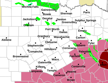
Texas
packyderms_wife
Neither here nor there.
LIVE STREAM - Max Velocity
BREAKING TORNADO ON THE GROUND IN TEXAS - Tornadoes, Damaging Winds - With Live Storm Chaser
packyderms_wife
Neither here nor there.
Tornado Warning
TXC145-395-282115-
/O.NEW.KFWD.TO.W.0022.240428T2030Z-240428T2115Z/
BULLETIN - EAS ACTIVATION REQUESTED
Tornado Warning
National Weather Service Fort Worth TX
330 PM CDT Sun Apr 28 2024
The National Weather Service in Fort Worth has issued a
* Tornado Warning for...
Central Robertson County in central Texas...
East central Falls County in central Texas...
* Until 415 PM CDT.
* At 330 PM CDT, a severe thunderstorm capable of producing a tornado
was located near Bremond, or 17 miles southeast of Marlin, moving
east at 25 mph.
HAZARD...Tornado and half dollar size hail.
SOURCE...Radar indicated rotation.
IMPACT...Flying debris will be dangerous to those caught without
shelter. Mobile homes will be damaged or destroyed.
Damage to roofs, windows, and vehicles will occur. Tree
damage is likely.
* This dangerous storm will be near...
Bremond around 335 PM CDT.
Twin Oak Reservoir around 400 PM CDT.
Other locations impacted by this tornadic thunderstorm include
Easterly, New Baden, Bald Prairie, and Reagan.
PRECAUTIONARY/PREPAREDNESS ACTIONS...
Heavy rainfall may hide this tornado. Do not wait to see or hear the
tornado. TAKE COVER NOW!
&&
LAT...LON 3100 9675 3100 9677 3102 9677 3103 9678
3105 9677 3105 9678 3106 9679 3106 9681
3107 9681 3121 9679 3126 9662 3122 9659
3131 9641 3105 9633 3098 9676
TIME...MOT...LOC 2030Z 254DEG 22KT 3110 9674
TORNADO...RADAR INDICATED
MAX HAIL SIZE...1.25 IN
$$
Dunn
night driver
ESFP adrift in INTJ sea
We are expecting Ryan and Max to reprise their efforts from the last few days up here in North Mid West (CLE) in the afternoon as we're going to see unseasonably warm wet atmosphere for Monday and Tuesday.
packyderms_wife
Neither here nor there.
Severe Weather Statement
National Weather Service Fort Worth TX
324 PM CDT Sun Apr 28 2024
TXC161-282045-
/O.CON.KFWD.TO.W.0020.000000T0000Z-240428T2045Z/
Freestone TX-
324 PM CDT Sun Apr 28 2024
...A TORNADO WARNING REMAINS IN EFFECT UNTIL 345 PM CDT FOR SOUTH
CENTRAL FREESTONE COUNTY...
At 323 PM CDT, a severe thunderstorm capable of producing a tornado
was located near Teague, moving northeast at 35 mph.
HAZARD...Tornado and quarter size hail.
SOURCE...Radar indicated rotation.
IMPACT...Flying debris will be dangerous to those caught without
shelter. Mobile homes will be damaged or destroyed. Damage
to roofs, windows, and vehicles will occur. Tree damage is
likely.
This tornadic thunderstorm will remain over mainly rural areas of
south central Freestone County, including the following locations...
Dew and Freestone.
PRECAUTIONARY/PREPAREDNESS ACTIONS...
Heavy rainfall may hide this tornado. Do not wait to see or hear the
tornado. TAKE COVER NOW!
&&
LAT...LON 3148 9627 3156 9633 3174 9618 3153 9601
TIME...MOT...LOC 2023Z 233DEG 31KT 3155 9624
TORNADO...RADAR INDICATED
MAX HAIL SIZE...1.00 IN
$$
Dunn
packyderms_wife
Neither here nor there.
Severe Weather Statement
National Weather Service Fort Worth TX
325 PM CDT Sun Apr 28 2024
TXC145-395-282045-
/O.CON.KFWD.TO.W.0021.000000T0000Z-240428T2045Z/
Robertson TX-Falls TX-
325 PM CDT Sun Apr 28 2024
...A TORNADO WARNING REMAINS IN EFFECT UNTIL 345 PM CDT FOR WEST
CENTRAL ROBERTSON AND SOUTHEASTERN FALLS COUNTIES...
At 325 PM CDT, a severe thunderstorm capable of producing a tornado
was located 9 miles southwest of Bremond, or 15 miles south of
Marlin, moving northeast at 25 mph.
HAZARD...Tornado and half dollar size hail.
SOURCE...Radar indicated rotation.
IMPACT...Flying debris will be dangerous to those caught without
shelter. Mobile homes will be damaged or destroyed. Damage
to roofs, windows, and vehicles will occur. Tree damage is
likely.
Locations impacted include...
Reagan.
PRECAUTIONARY/PREPAREDNESS ACTIONS...
Heavy rainfall may hide this tornado. Do not wait to see or hear the
tornado. TAKE COVER NOW!
&&
LAT...LON 3103 9678 3104 9677 3105 9677 3105 9678
3106 9679 3106 9682 3108 9681 3111 9683
3110 9685 3122 9678 3106 9663 3102 9677
TIME...MOT...LOC 2025Z 238DEG 20KT 3107 9679
TORNADO...RADAR INDICATED
MAX HAIL SIZE...1.25 IN
$$
Dunn
packyderms_wife
Neither here nor there.
Tornado Warning
TXC145-395-282115-
/O.NEW.KFWD.TO.W.0022.240428T2030Z-240428T2115Z/
BULLETIN - EAS ACTIVATION REQUESTED
Tornado Warning
National Weather Service Fort Worth TX
330 PM CDT Sun Apr 28 2024
The National Weather Service in Fort Worth has issued a
* Tornado Warning for...
Central Robertson County in central Texas...
East central Falls County in central Texas...
* Until 415 PM CDT.
* At 330 PM CDT, a severe thunderstorm capable of producing a tornado
was located near Bremond, or 17 miles southeast of Marlin, moving
east at 25 mph.
HAZARD...Tornado and half dollar size hail.
SOURCE...Radar indicated rotation.
IMPACT...Flying debris will be dangerous to those caught without
shelter. Mobile homes will be damaged or destroyed.
Damage to roofs, windows, and vehicles will occur. Tree
damage is likely.
* This dangerous storm will be near...
Bremond around 335 PM CDT.
Twin Oak Reservoir around 400 PM CDT.
Other locations impacted by this tornadic thunderstorm include
Easterly, New Baden, Bald Prairie, and Reagan.
PRECAUTIONARY/PREPAREDNESS ACTIONS...
Heavy rainfall may hide this tornado. Do not wait to see or hear the
tornado. TAKE COVER NOW!
&&
LAT...LON 3100 9675 3100 9677 3102 9677 3103 9678
3105 9677 3105 9678 3106 9679 3106 9681
3107 9681 3121 9679 3126 9662 3122 9659
3131 9641 3105 9633 3098 9676
TIME...MOT...LOC 2030Z 254DEG 22KT 3110 9674
TORNADO...RADAR INDICATED
MAX HAIL SIZE...1.25 IN
$$
Dunn
packyderms_wife
Neither here nor there.
Tornado Warning
TXC161-282115-
/O.NEW.KFWD.TO.W.0023.240428T2037Z-240428T2115Z/
BULLETIN - EAS ACTIVATION REQUESTED
Tornado Warning
National Weather Service Fort Worth TX
337 PM CDT Sun Apr 28 2024
The National Weather Service in Fort Worth has issued a
* Tornado Warning for...
Southeastern Freestone County in central Texas...
* Until 415 PM CDT.
* At 337 PM CDT, a severe thunderstorm capable of producing a tornado
was located 7 miles southeast of Teague, moving east at 30 mph.
HAZARD...Tornado and half dollar size hail.
SOURCE...Radar indicated rotation.
IMPACT...Flying debris will be dangerous to those caught without
shelter. Mobile homes will be damaged or destroyed.
Damage to roofs, windows, and vehicles will occur. Tree
damage is likely.
* This tornadic thunderstorm will remain over mainly rural areas of
southeastern Freestone County, including the following locations...
Lanely, Dew, and Red Lake.
This includes Interstate 45 between mile markers 185 and 196.
PRECAUTIONARY/PREPAREDNESS ACTIONS...
Motorists should not take shelter under highway overpasses. If you
cannot safely drive away from the tornado, as a last resort, abandon
your vehicle and lie down in a low lying area and protect yourself
from flying debris.
&&
LAT...LON 3164 9580 3162 9579 3161 9581 3151 9618
3163 9627 3184 9599 3182 9597 3179 9598
3175 9588 3174 9587 3174 9588 3172 9587
3172 9588 3169 9587 3170 9583 3167 9581
3168 9578
TIME...MOT...LOC 2037Z 247DEG 28KT 3158 9618
TORNADO...RADAR INDICATED
MAX HAIL SIZE...1.25 IN
$$
Dunn
packyderms_wife
Neither here nor there.
We are expecting Ryan and Max to reprise their efforts from the last few days up here in North Mid West (CLE) in the afternoon as we're going to see unseasonably warm wet atmosphere for Monday and Tuesday.
Max is live right now, I posted a link to his live stream several posts up.
packyderms_wife
Neither here nor there.
Tornado Warning
TXC001-161-282200-
/O.NEW.KFWD.TO.W.0024.240428T2100Z-240428T2200Z/
BULLETIN - EAS ACTIVATION REQUESTED
Tornado Warning
National Weather Service Fort Worth TX
400 PM CDT Sun Apr 28 2024
The National Weather Service in Fort Worth has issued a
* Tornado Warning for...
East central Freestone County in central Texas...
Central Anderson County in central Texas...
* Until 500 PM CDT.
* At 400 PM CDT, a severe thunderstorm capable of producing a
tornado was located 10 miles southeast of Fairfield Lake State
Park, or 10 miles east of Fairfield, moving east at 40 mph.
HAZARD...Tornado and quarter size hail.
SOURCE...Radar indicated rotation.
IMPACT...Flying debris will be dangerous to those caught without
shelter. Mobile homes will be damaged or destroyed.
Damage to roofs, windows, and vehicles will occur. Tree
damage is likely.
* This dangerous storm will be near...
Palestine around 415 PM CDT.
Other locations impacted by this tornadic thunderstorm include
Tucker, Pert, Johnson, Crystal Lake, Todd City, Neches, Massey Lake,
Tennessee Colony, Red Lake, and Cedar Creek.
PRECAUTIONARY/PREPAREDNESS ACTIONS...
Heavy rainfall may hide this tornado. Do not wait to see or hear the
tornado. TAKE COVER NOW!
&&
LAT...LON 3171 9534 3164 9572 3165 9574 3165 9575
3163 9575 3159 9594 3183 9601 3197 9544
3196 9545 3193 9542 3190 9544 3188 9543
3185 9545 3182 9540 3176 9540 3175 9536
3173 9537 3173 9533
TIME...MOT...LOC 2100Z 252DEG 34KT 3170 9594
TORNADO...RADAR INDICATED
MAX HAIL SIZE...1.00 IN
$$
Dunn
packyderms_wife
Neither here nor there.
Tornado Warning
TXC289-395-282215-
/O.NEW.KFWD.TO.W.0025.240428T2109Z-240428T2215Z/
BULLETIN - EAS ACTIVATION REQUESTED
Tornado Warning
National Weather Service Fort Worth TX
409 PM CDT Sun Apr 28 2024
The National Weather Service in Fort Worth has issued a
* Tornado Warning for...
Northeastern Robertson County in central Texas...
Southwestern Leon County in central Texas...
* Until 515 PM CDT.
* At 408 PM CDT, a severe thunderstorm capable of producing a tornado
was located near Twin Oak Reservoir, or 20 miles north of Hearne,
moving east at 30 mph.
HAZARD...Tornado and half dollar size hail.
SOURCE...Radar indicated rotation.
IMPACT...Flying debris will be dangerous to those caught without
shelter. Mobile homes will be damaged or destroyed.
Damage to roofs, windows, and vehicles will occur. Tree
damage is likely.
* This dangerous storm will be near...
Centerville around 500 PM CDT.
Other locations impacted by this tornadic thunderstorm include
Redland, Jewett, Marquez, Leona, Easterly, Corinth, Robbins, Flynn,
Bald Prairie, and Ridge.
This includes Interstate 45 between mile markers 153 and 174.
PRECAUTIONARY/PREPAREDNESS ACTIONS...
Motorists should not take shelter under highway overpasses. If you
cannot safely drive away from the tornado, as a last resort, abandon
your vehicle and lie down in a low lying area and protect yourself
from flying debris.
&&
LAT...LON 3105 9651 3125 9651 3144 9594 3110 9593
TIME...MOT...LOC 2108Z 252DEG 25KT 3116 9646
TORNADO...RADAR INDICATED
MAX HAIL SIZE...1.25 IN
$$
Dunn
packyderms_wife
Neither here nor there.
packyderms_wife
Neither here nor there.
I'm going to go take a break from the weather, OC is almost done chopping pineapple for the dehydrator, and next up homemade blackberry jam. Stay safe everyone.
I'm going to go take a break from the weather, OC is almost done chopping pineapple for the dehydrator, and next up homemade blackberry jam. Stay safe everyone.
Procedural error
Pineapple, coconut, rum, blender.
Just called he who signs a lot of my checks..
"We working in Sulfur tomorrow?"
"Hellifino, I'm watching a tornado pass over my house."
"I don't give a $#it about that, it's not my house...call me when you're out of the fraidy-hole."

"We working in Sulfur tomorrow?"
"Hellifino, I'm watching a tornado pass over my house."
"I don't give a $#it about that, it's not my house...call me when you're out of the fraidy-hole."
Tornadoes popping up.
Shreveport may get hit.
Red boxes, eastern Ok. & Tx. west La.

Shreveport may get hit.
Red boxes, eastern Ok. & Tx. west La.
packyderms_wife
Neither here nor there.
NWS is saying the Sulphur OK tornado was an EF3.
packyderms_wife
Neither here nor there.
RT 9:20 - Max Velocity
In this weather forecast, we are breaking down ANOTHER BIG storm that will bring a multi-day severe weather event to the United States. This will bring more severe weather like damaging winds, large hail, and tornadoes. Find the latest details of the weather across the United States in our latest weather forecast.
Today

Tomorrow.
Dorothy should keep Toto nearby.

Tomorrow.
Dorothy should keep Toto nearby.
packyderms_wife
Neither here nor there.
Tornado watch box up for southwestern Iowa.
packyderms_wife
Neither here nor there.
LIVE STREAM - Max Velocity
In this live stream, we are breaking down upcoming severe weather in the United States. This severe weather event could bring significant damaging winds, large hail, and tornadoes. This is a live weather channe
packyderms_wife
Neither here nor there.
Chasers are all on deck this afternoon, many about three hours earlier than they had posted they'd be live.
View: https://www.youtube.com/watch?v=nFKemJaYstU
️ENHANCED RISK:Live Storm Chaser-Big Hail and Severe Weather Likely in Nebraska, Iowa, and Kansas!
LIVE STREAM - Vince Waelti
️ENHANCED RISK:Live Storm Chaser-Big Hail and Severe Weather Likely in Nebraska, Iowa, and Kansas!
LIVE STREAM - Vince Waelti
Watch now extended to cover a large portion of the state. Got a reverse 911 call about 40 minutes ago and I did not like the percentages of risk they gave.Tornado watch box up for southwestern Iowa.
Tornado risk

Hail
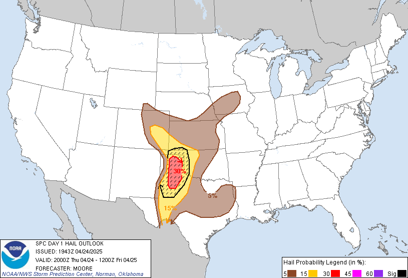
Hail
packyderms_wife
Neither here nor there.
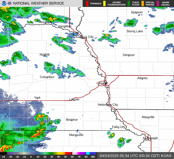
Tornado Warning
IAC129-137-155-302115-
/O.NEW.KOAX.TO.W.0052.240430T2036Z-240430T2115Z/
BULLETIN - EAS ACTIVATION REQUESTED
Tornado Warning
National Weather Service Omaha/Valley Nebraska
336 PM CDT Tue Apr 30 2024
The National Weather Service in Omaha has issued a
* Tornado Warning for...
Northern Montgomery County in southwestern Iowa...
Northeastern Mills County in southwestern Iowa...
Southeastern Pottawattamie County in southwestern Iowa...
* Until 415 PM CDT.
* At 336 PM CDT, a severe thunderstorm capable of producing a tornado
was located over Hastings, or 15 miles west of Red Oak, moving
northeast at 35 mph.
HAZARD...Tornado and tennis ball size hail.
SOURCE...Radar indicated rotation.
IMPACT...Flying debris will be dangerous to those caught without
shelter. Mobile homes will be damaged or destroyed.
Damage to roofs, windows, and vehicles will occur. Tree
damage is likely.
* This dangerous storm will be near...
Emerson and Hastings around 340 PM CDT.
Henderson around 350 PM CDT.
Elliott around 410 PM CDT.
Other locations impacted by this tornadic thunderstorm include Farm
Creek Public Wildlife Area and Old Town Park.
PRECAUTIONARY/PREPAREDNESS ACTIONS...
TAKE COVER NOW! Move to a basement or an interior room on the lowest
floor of a sturdy building. Avoid windows. If you are outdoors, in a
mobile home, or in a vehicle, move to the closest substantial shelter
and protect yourself from flying debris.
&&
LAT...LON 4096 9545 4096 9563 4109 9562 4137 9516
4135 9515 4116 9516 4116 9493 4114 9492
4105 9493
TIME...MOT...LOC 2036Z 234DEG 29KT 4102 9552
TORNADO...RADAR INDICATED
MAX HAIL SIZE...2.50 IN
$$
Petersen
packyderms_wife
Neither here nor there.
Iowa
packyderms_wife
Neither here nor there.
Lots of watch boxes popping up!
packyderms_wife
Neither here nor there.
Tornado Warning
KSC117-131-302230-
/O.NEW.KTOP.TO.W.0022.240430T2155Z-240430T2230Z/
BULLETIN - EAS ACTIVATION REQUESTED
Tornado Warning
National Weather Service Topeka KS
455 PM CDT Tue Apr 30 2024
The National Weather Service in Topeka has issued a
* Tornado Warning for...
Southern Nemaha County in northeastern Kansas...
East central Marshall County in northeastern Kansas...
* Until 530 PM CDT.
* At 455 PM CDT, a severe thunderstorm capable of producing a tornado
was located near Vermillion, moving east at 45 mph.
HAZARD...Tornado and hail up to two inches in diameter.
SOURCE...Radar indicated rotation.
IMPACT...Flying debris will be dangerous to those caught without
shelter. Mobile homes will be damaged or destroyed.
Damage to roofs, windows, and vehicles will occur. Tree
damage is likely.
* Locations impacted include...
Centralia, Corning, Goff, Vermillion, and Woodlawn.
PRECAUTIONARY/PREPAREDNESS ACTIONS...
TAKE COVER NOW! Move to a basement or an interior room on the lowest
floor of a sturdy building. Avoid windows. If you are outdoors, in a
mobile home, or in a vehicle, move to the closest substantial shelter
and protect yourself from flying debris.
&&
LAT...LON 3964 9633 3976 9632 3985 9586 3961 9582
TIME...MOT...LOC 2155Z 271DEG 39KT 3969 9621
TORNADO...RADAR INDICATED
MAX HAIL SIZE...2.00 IN
$$
101
Several chasers up thataway.
Donna_in_OK
Veteran Member
Live in Oklahoma - More tornado warnings with damage:
View: https://www.youtube.com/watch?v=0NTLlPD-3GA
packyderms_wife
Neither here nor there.
It’s hailing again, just north of Des Moines Iowa. It’s really bad on the west side of town.
packyderms_wife
Neither here nor there.
Tornado warnings south central Iowa. I’m on my phone.