ALERT Southern Severe Weather Outbreak Under Way

msswv123

Veteran Member
A major early season severe weather outbreak is taking shape tonight, spanning about a dozen states from the Deep South to the Ohio Valley.

Some of the thunderstorms are even expected to spawn tornadoes, making for an especially dangerous situation given the veil of night.

Several factors have come together for this rare, significant January severe weather event. A cold front marking the leading edge of colder air will slice into an unusually warm and moist air mass.

The threat for twisters will come via a powerful and rotating blast of air arriving in the upper levels of the atmosphere.

While a widespread tornado outbreak is not anticipated, the enhanced threat existing tonight is certainly noteworthy. A few destructive, long-track tornadoes are quite possible.

Cities at risk for these damaging severe storms through tonight include: Cape Girardeau, Mo.; Evansville, Ind.; Cincinnati, Ohio; Lexington, Louisville and Bowling Green, Ky.; Chattanooga, Memphis and Nashville, Tenn.; Jackson and Tupelo, Miss.; and Birmingham, Huntsville and Montgomery, Ala.

snip

Beginning this evening, the Mississippi Valley will be the first threatened by severe storms, stretching from near the junction of the Mississippi and Ohio rivers south to northern Louisiana.
Overnight, the lower Ohio Valley, much of Kentucky and Tennessee, as well as the Deep South will become the focal point for the powerful storms.

Powerful wind gusts above 60 mph, capable of downing trees and power lines will be the largest threat faced from any thunderstorm. Pelting hail up to the size of golf balls will also be possible.
Most of the storms will sweep east in a line, heightening the risk for widespread wind damage. Additional storms will form ahead of the main line, and those too could turn severe.

http://www.accuweather.com/en/weather-news/severe-outbreak-with-tornadoes/60560
 

Red Baron

Paleo-Conservative
_______________
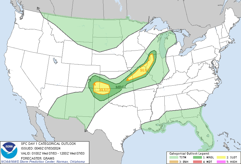
Moderate Risk issued by the NWS Storm Prediction Center for the South Central United States through tonight,

day1otlk_0100.gif


DAY 1 CONVECTIVE OUTLOOK
NWS STORM PREDICTION CENTER NORMAN OK
0631 PM CST SUN JAN 22 2012

VALID 230100Z - 231200Z

...THERE IS A MDT RISK OF SVR TSTMS ACROSS PARTS OF ERN
AR...NRN-CNTRL MS...NW AL...WRN/CNTRL TN...SE MO...SRN IL...SRN IND
AND WRN KY...

...THERE IS A SLGT RISK OF SVR TSTMS ACROSS PARTS OF THE LOWER TO
MID-MS VALLEY...OZARKS...OH AND TN VALLEYS...

...LOWER TO MID MS VALLEY/OH AND TN VALLEYS...
A SEVERE WEATHER EVENT IS BEGINNING TO UNFOLD WITH A RAPID INCREASE
IN CONVECTIVE COVERAGE OVER THE LAST HOUR IN CNTRL AR. THIS IS
OCCURRING AHEAD OF A POWERFUL NEGATIVELY-TILED UPPER-LEVEL TROUGH
MOVING ACROSS THE PLAINS STATES. THIS BANDED CONVECTION IN CNTRL AR
SHOULD GRADUALLY INTENSIFY AND SHIFT ENEWD TOWARD THE MS RIVER
BETWEEN NOW AND 03Z. AHEAD OF THE CONVECTION...SFC DEWPOINTS WILL
INCREASE INTO THE MID 60S F RESULTING IN RAPID DESTABILIZATION WITH
MODERATE INSTABILITY DEVELOPING FROM THE MEMPHIS AREA SWD ACROSS NRN
MS. THIS COMBINED WITH 55 TO 70 KT OF DEEP LAYER SHEAR AND STORM
RELATIVE HELICITIES IN THE 400 TO 450 M2/S2 RANGE WILL BE FAVORABLE
FOR SUPERCELLS AND TORNADOES. THE CURRENT THINKING IS THAT A FEW
STRONG TORNADOES MAY OCCUR FROM AROUND THE MO BOOTHEEL SWD ACROSS
THE MEMPHIS AREA INTO ERN AR AND NRN MS. AS A LINE OF INTENSE STORMS
ORGANIZES...THE WIND DAMAGE THREAT SHOULD INCREASE WITH A
SQUALL-LINE MOVING EWD ACROSS THE MODERATE RISK AREA THIS EVENING
AND DURING THE OVERNIGHT PERIOD. THE THREAT FOR STRONG TORNADOES
COULD PERSIST LATE THIS EVENING FROM WRN TN SWD INTO NCNTRL MS AND
WRN AL WITH EMBEDDED ROTATING CELLS WITHIN THE LINE OR AT THE SRN
END OF THE LINE. AN ENHANCED WIND DAMAGE THREAT APPEARS LIKELY TO
EXIST ALONG MUCH OF THE LENGTH OF THE SQUALL-LINE AND SOME GUSTS
ABOVE 70 KT WILL BE POSSIBLE WITH BOWING LINE-SEGMENTS.
OVERALL...THE PREVIOUS OUTLOOK APPEARS TO HAVE A GOOD HANDLE ON THE
SITUATION. THE ONLY APPRECIABLE CHANGES FOR THE 01Z OUTLOOK ARE TO
ADD THUNDER BACK ACROSS CNTRL AND WRN MO ASSOCIATED WITH
THUNDERSTORMS ONGOING SOUTH OF KANSAS CITY AND TO REMOVE THUNDER
ACROSS PARTS OF SE TX.

..BROYLES.. 01/23/2012
 

msswv123

Veteran Member
The threat for twisters will come via a powerful and rotating blast of
air arriving in the upper levels of the atmosphere.


Just had CME impact don't know if that is affecting this but here's the latest on that:

CME IMPACT: Arriving a little later than expected, a coronal mass ejection (CME) hit Earth's magnetic field at 0617 UT on Jan. 22nd. According to analysts at the Goddard Space Weather Lab, the impact strongly compressed Earth's magnetic field and briefly exposed satellites in geosynchronous orbit to solar wind plasma. Shifting lines of magnetic force induced strong ground currents in Norway and sparked bright auroras over the upper reaches of North America.

The impact also disturbed Earth's ionosphere. In Atlanta, Georgia, radio engineer Pieter Ibelings monitored a 4.5 MHz CODAR (coastal radar) signal as it bounced off layers of ionization along the US east coast. "The moment of impact can be clearly seen on the CODAR radar plot,"

http://spaceweather.com/
 

Red Baron

Paleo-Conservative
_______________
8:08 CST NWS radar from Little Rock.

Two Tornadic Votex Signatures (TVS) indicated by the blue triangles,
 

Attachments

  • WUNIDS_map.gif
    WUNIDS_map.gif
    41.9 KB · Views: 238

msswv123

Veteran Member
Tornado Watch: Benton, MS; Coahoma, MS; Craighead, AR; Crittenden, AR; Crockett, TN; Cross, AR; DeSoto, MS; Dunklin, MO; Dyer, TN; Fayette, TN; Gibson, TN; Hardeman, TN; Haywood, TN; Lafayette, MS; Lauderdale, TN; Lee, AR; Madison, TN; Marshall, MS; Mississippi, AR; Panola, MS; Pemiscot, MO; Phillips, AR; Poinsett, AR; Pulaski, AR; Quitman, MS; Saint Francis, AR; Shelby, TN; Tate, MS; Tipton, TN; Tunica, MS
 

Red Baron

Paleo-Conservative
_______________
PRELIMINARY LOCAL STORM REPORT
NATIONAL WEATHER SERVICE LITTLE ROCK AR
806 PM CST SUN JAN 22 2012

..TIME... ...EVENT... ...CITY LOCATION... ...LAT.LON...
..DATE... ....MAG.... ..COUNTY LOCATION..ST.. ...SOURCE....
..REMARKS..

0759 PM FUNNEL CLOUD 10 SE HAZEN 34.69N 91.45W
01/22/2012 PRAIRIE AR AMATEUR RADIO

AMATEUR RADIO OPERATOR REPORTS TWO FUNNEL CLOUDS 10 MILES
SOUTHEAST OF HAZEN.
 

Red Baron

Paleo-Conservative
_______________
PRELIMINARY LOCAL STORM REPORT
NATIONAL WEATHER SERVICE LITTLE ROCK AR
803 PM CST SUN JAN 22 2012

..TIME... ...EVENT... ...CITY LOCATION... ...LAT.LON...
..DATE... ....MAG.... ..COUNTY LOCATION..ST.. ...SOURCE....
..REMARKS..

0759 PM TORNADO 2 N SLOVAK 34.68N 91.58W
01/22/2012 PRAIRIE AR AMATEUR RADIO

AMATEUR RADIO OPERATOR REPORTS A TORNADO ON THE GROUND 2
MILES NORTH OF SLOVAK.
 

msswv123

Veteran Member
JONESBORO, AR (KAIT) – Severe weather has started battering parts of Region 8 Sunday evening bringing hail, strong winds, and dangerous lightning to the state.
The National Weather Service has all of Region 8 under a Tornado Watch until Midnight. There have already been several severe thunderstorm warnings issued from Region 8 counties.

Tornadoes, damaging winds, large hail, and heavy rainfall are all possible with these storms. Monitor the weather conditions and check for any alerts as the night progresses. Review your severe weather plans now so you know where to go if there's a warning issued for your area.

Hail pics here ...some pretty large hail

http://www.kait8.com/story/16571510/severe-weather-begins-to-hit-region-8
 

Red Baron

Paleo-Conservative
_______________
mcd0051.gif


MESOSCALE DISCUSSION 0051
NWS STORM PREDICTION CENTER NORMAN OK
0837 PM CST SUN JAN 22 2012

AREAS AFFECTED...PORTIONS OF THE LOWER/MID-MS VALLEY

CONCERNING...TORNADO WATCH 5...6...

VALID 230237Z - 230400Z

THE SEVERE WEATHER THREAT FOR TORNADO WATCH 5...6...CONTINUES.
NRN/CNTRL PORTIONS OF QLCS FROM SWRN IL INTO NERN AR SHOULD
ACCELERATE E/NEWD WITH PRIMARY THREAT OF DAMAGING WINDS. GREATER
TORNADO THREAT SHOULD PERSIST ALONG THE BROKEN SRN PORTION OF THE
LINE ACROSS E-CNTRL/SERN AR EVOLVING ACROSS THE MS RIVER.


AS OF 0230Z...A 450-MI LONG QLCS EXTENDED FROM SWRN IL INTO S-CNTRL
AR. GREATEST RELATIVE SEVERE THREAT EXISTS ALONG THE SRN PORTION OF
THIS LINE WITH A FEW LONG-TRACKED SUPERCELLS NOW PROGRESSING INTO
PARTS OF E-CNTRL/SERN AR. EFFECTIVE SRH WILL REMAIN EXTREME AOA 500
M2/S2 AND WITHIN THE BROADEST WARM SECTOR CHARACTERIZED BY 62-64 F
SURFACE DEW POINTS...POTENTIAL FOR SIGNIFICANT TORNADOES REMAINS
HIGH AS ACTIVITY APPROACHES SWRN TN/NWRN MS.


THE SOLID LINEAR STRUCTURE FARTHER N WITHIN A COMPARATIVELY NARROW
SURFACE-BASED WARM SECTOR SHOULD PREDOMINATELY FAVOR DAMAGING WINDS.
ALTHOUGH OBSERVED METAR GUSTS HAVE REMAINED IN THE 35-40 KT RANGE
THUS FAR IN SERN MO/NERN AR...THE ORGANIZED STRUCTURE OF THE LINE
AMIDST STRONG MID-LEVEL DCVA MAY AID IN FURTHER INTENSIFICATION AS
IT CROSSES THE MS RIVER TOWARDS THE LOWER OH VALLEY
. FOR ADDITIONAL
INFORMATION FARTHER N OF WW 6...PLEASE SEE MCD 50.

..GRAMS.. 01/23/2012
 

Red Baron

Paleo-Conservative
_______________
PRELIMINARY LOCAL STORM REPORT
NATIONAL WEATHER SERVICE LITTLE ROCK AR
845 PM CST SUN JAN 22 2012

..TIME... ...EVENT... ...CITY LOCATION... ...LAT.LON...
..DATE... ....MAG.... ..COUNTY LOCATION..ST.. ...SOURCE....
..REMARKS..

0838 PM TORNADO 1 W BURKS 34.30N 91.42W
01/22/2012 ARKANSAS AR STORM CHASER

TORNADO REPORTED ON THE GROUND 1 MILE WEST OF BURKS.

---------


PRELIMINARY LOCAL STORM REPORT
NATIONAL WEATHER SERVICE LITTLE ROCK AR
843 PM CST SUN JAN 22 2012

..TIME... ...EVENT... ...CITY LOCATION... ...LAT.LON...
..DATE... ....MAG.... ..COUNTY LOCATION..ST.. ...SOURCE....
..REMARKS..

0833 PM TORNADO 4 NW DE WITT 34.33N 91.39W
01/22/2012 ARKANSAS AR STORM CHASER

TORNADO REPORTED ON THE GROUND BY STORM CHASERS 4 MILES
NORTHWEST OF DE WITT.
 

bad_karma00

Underachiever
Looks bad right now, and we're in the path. Let you know what happens. That's assuming, of course, that it doesn't 'happen' to me. We're good for another hour, maybe two, but the wind here is already roaring, and worse yet, the temp is actually rising.
 

msswv123

Veteran Member
Yes everyone stay safe...every article I've read say be ready to shelter...here's the weatherchannel link with a live twitter feed....blessings T


A significant January severe weather outbreak is forecast to strike parts of the Lower Mississippi Valley, the Ohio Valley and the Mid-South regions.

This is an outbreak that will unfold over the late evening hours of Sunday night into the wee hours of Monday morning.

Our updates will include forecasting analysis, significant tornado alerts, storm damage reports, radar analysis, storm photos and much more.

http://www.weather.com/outlook/weather-news/news/articles/january-severe-weather-outbreak_2012-01-22
 

msswv123

Veteran Member
Stu Ostro:
The image below is a model analysis of a very potent core of winds in the middle part of the atmosphere this evening; as it continues crashing E and NE into warm, moist, unstable air, the threat for severe weather will continue overnight

Sunday January 22, 2012 10:02 Stu Ostro
10:02


Matt - Weather.com:

Jim Cantore: "Storms moving NE at approx 65mph"


Tim Ballisty weather.com:
Yes, Matt - the storms are cruising. Will not allow many to prepare if they don't pay attention.

Tim Ballisty weather.com:
You have friends in Memphis? Let them know about the line of severe thunderstorms that are approaching the city.
 
Last edited:

Red Baron

Paleo-Conservative
_______________
Live streaming severe weather TV coverage from WREG Memphis,

http://www.wreg.com/

Average speed of the storms cells are 50+ mph which wil create a severe wind threat along with tonadoes and large hail.

People in the Memphis TN area should avoid driving and finish preparations before the storm arrives.
 

Publius

TB Fanatic
I'm well north east of this and we're now getting very fine snow flakes and have wait and see how this may effect us.
 

msswv123

Veteran Member
Live feed:

Stu Ostro:
Also, dangerous cloud-to-ground lightning. In fact, an extraordinary amount of it for so far north in January.


eta:

I hope everyone takes this seriously and if you have loved ones or friends in the path of these storms warn them...After that MONSTER in Joplin last year it pays to be alert. This happening at night is not a good thing for sure...blessings T
 

TerriHaute

Hoosier Gardener
We have been keeping an eye on this storm system too. Local Indianapolis weathermen have been telling us to expect severe thunderstorms tonight. On the radar, it looks like the storms are growing very strong and expanding quickly and will soon cross over the state line. It has been creepy all afternoon. The temperature has been rising all day and as soon as it went above freezing, the ice and snow started evaporating into fog. Eerie to have it this warm (45 degrees at 10:30PM) with fog and thunderstorms in the middle of January. The weather alert radio is definitely going to be turned on tonight.
 

Red Baron

Paleo-Conservative
_______________
The NWS Storm Prediction Center is currently debating a Weather Watch issuance for portions of IN and IL.


mcd0050.gif


MESOSCALE DISCUSSION 0050
NWS STORM PREDICTION CENTER NORMAN OK
0825 PM CST SUN JAN 22 2012

AREAS AFFECTED...CNTRL/ERN IL AND WRN/CNTRL IND

CONCERNING...SEVERE POTENTIAL...WATCH POSSIBLE

VALID 230225Z - 230430Z

THUNDERSTORMS WILL INCREASE IN COVERAGE ACROSS CNTRL/ERN IL AND
WRN/CNTRL IND TONIGHT. MARGINAL SVR WEATHER THREAT WILL EXIST WITH
THIS ACTIVITY...ENVIRONMENTAL TRENDS WILL CONTINUE TO BE MONITORED
FOR A WW.

AT 02Z...A 996 MB SURFACE LOW WAS MOVING FROM ERN KS INTO WRN
MO...AND IS FORECAST TO TRACK NEWD INTO NRN IL DURING THE OVERNIGHT
HOURS. STRONG SLY LOW-LEVEL FLOW AHEAD OF THE CYCLONE WILL CONTINUE
TO AID IN THE NWD ADVECTION OF MOISTURE /AROUND 8-10 C AT 850 MB/
ABOVE A COOL STABLE SURFACE AIRMASS /TEMPERATURES RANGING FROM NEAR
40F OVER NRN IND TO AROUND 60F OVER SRN IL AND SRN IND/. AS STRONG
FORCING FOR ASCENT CONTINUES TO OVERSPREAD THE REGION THROUGH
06Z...HI-RES MODEL GUIDANCE SUGGESTS STORMS WILL EXPAND IN COVERAGE
NWD OUT OF SRN IL INTO PORTIONS OF CNTRL/ERN IL...AND THEN MOVE EWD
INTO WRN/CNTRL IND. IT IS QUESTIONABLE WHETHER ROBUST BOUNDARY LAYER
DESTABILIZATION WILL OCCUR OVER IL/IND...WHICH WOULD BE PROBLEMATIC
FOR AN APPRECIABLE SVR WEATHER RISK. HOWEVER...GIVEN THE
STRONG/DYNAMIC NATURE OF THE EJECTING CYCLONE...OBSERVATIONAL TRENDS
WILL BE MONITORED CLOSELY DURING THE NIGHT FOR SIGNS OF GREATER THAN
ANTICIPATED DESTABILIZATION.
..GARNER.. 01/23/2012
 

gisgaia

Veteran Member
Stu Ostro: The image below is a model analysis of a very potent core of winds in the middle part of the atmosphere this evening; as it continues crashing E and NE into warm, moist, unstable air, the threat for severe weather will continue overnight

Sunday January 22, 2012 10:02 Stu Ostro
10:02


Matt - Weather.com: Jim Cantore: " Storms moving NE at approx 65mph"

Tim Ballisty weather.com: Yes, Matt - the storms are cruising. Will not allow many to prepare if they don't pay attention.

Tim Ballisty weather.com: You have friends in Memphis? Let them know about the line of severe thunderstorms that are approaching the city.

******************************************

Just got back to house from shopping trip around 100 miles west of DFW area this evening and it was one WILD ride going into super-high winds + a major Dust Storm coming in from West Texas; it was blowing winds 40-50 mph sustained and gusts at least 60+ and we had no idea this was going on till we got into it!

In Msswv's reply quoted above, I just bolded in red that remark about how the tornadic storms in Arkansas moving "northeast at 65 mph" as was thinking just a few hours ago about how the winds we were experiencing on our trip were sure looking like they were going to cause some major trouble somewhere tonight... And now look what's happening with this really severe situation of multiple twisters in eastern Arkansas & now approaching Memphis along w/ many other areas to east & northeast --> wow!

It was also very warm here today, almost 80 degrees F but yesterday was more normal about 52 F. January is usually the period that begins our coldest weather here in Dallas area, blue-tail northers that bring ice storms / snow but who knows anymore what's what ?!?

Saw a Sorcha Faal report today talking about how underground tectonic activity in western Mexico along Coast has also showed concomittant signs of atmospheric heating and links to warnings about southwestern USA EQ dangers in California near Mexico border regions, etc here is that link: http://www.whatdoesitmean.com/index1556.htm

In Texas today, we heard on radio news that roads were closed near Lubbock due to blinding dust storm w/ winds over 60mph ... and here is link/snip to news about that:

QUOTE - FAIR USE CITED/SNIP:

Dust storm warning for Lubbock area [TEXAS] WFAA
http://www.wfaa.com/news/texas-news/Dust-storm-warning-in-West-Texas-137850048.html

Posted on January 22, 2012 at 10:46 AM Updated today at 11:02 AM

Dust storm warning
Map data ©2012 - Terms of Use33.56 -101.87

The National Weather Service has issued a dust storm warning for Lubbock and other parts of the Texas South Plains through 4 p.m. Sunday.

Forecasters say high winds gusting to 65 mph will reduce visibility to less than a half-mile, and — in some cases — to near zero.

Motorists are warned of extremely hazardous crosswinds and poor visibility in blowing dust, and travel is not recommended.

Power lines and weak outdoor structures are also potential targets of the wind and dust.
/// END SNIP QUOTE
 

msswv123

Veteran Member
11:00

Comment From Adam
Sirens going off on Mud Island


10:58

Tim Ballisty weather.com:
Tornado Warning for Shelby, TN and Crittenden, St. Francis, AR and DeSoto, MS until 10:45pm CT.
At 9:55, trained spotters reported a tornado near Simsboro moving NE at 55 mph.

10:54
Tim Ballisty weather.com:

Twitter is down for maintenance. Not good.

Tornado warning for Crockett, Gibson, Haywood counties in Tenn. Possible tornado near Forked Deer, TN moving NE at 40 mph. #severe #tnwx


11:13
spacer.gif

Sirens are going off in Southaven, MS.
Sunday January 22, 2012 11:13 Sarah
11:13
spacer.gif

Sirens going off in Martin, TN
Sunday January 22, 2012 11:13 Guest

11:13
spacer.gif

Sirens going off in Gibson County
Sunday January 22, 2012 11:13 Victor

11:13
spacer.gif

Sirens going off in Bradford, TN.

Comment From TiffanyTiffany: ]

Sirens going on in Olive Branch, MS!!!
 
Last edited:

gisgaia

Veteran Member
DUST STORM / WEATHER REPORTS DFW 10:20 PM CST

******************************************

Just got back to house from shopping trip around 100 miles west of DFW area this evening and it was one WILD ride going into super-high winds + a major Dust Storm coming in from West Texas; it was blowing winds 40-50 mph sustained and gusts at least 60+ and we had no idea this was going on till we got into it!

In Msswv's reply quoted above[#23] I bolded in red that remark about how the tornadic storms in Arkansas moving "northeast at 65 mph" as was thinking just a few hours ago about how the winds we were experiencing on our trip were sure looking like they were going to cause some major trouble somewhere tonight... And now look what's happening with this really severe situation of multiple twisters in eastern Arkansas & now approaching Memphis along w/ many other areas to east & northeast --> wow!

It was also very warm here today, almost 80 degrees F but yesterday was more normal about 52 F. January is usually the period that begins our coldest weather here in Dallas area, blue-tail northers that bring ice storms / snow but who knows anymore what's what ?!?

Saw a Sorcha Faal report today talking about how underground tectonic activity in western Mexico along Coast has also showed concomittant signs of atmospheric heating and links to warnings about southwestern USA EQ dangers in California near Mexico border regions, etc here is that link: http://www.whatdoesitmean.com/index1556.htm

In Texas today, we heard on radio news that roads were closed near Lubbock due to blinding dust storm w/ winds over 60mph ... and here is link/snip to news about that:

QUOTE - FAIR USE CITED/SNIP:

Dust storm warning for Lubbock area [TEXAS] WFAA
http://www.wfaa.com/news/texas-news/Dust-storm-warning-in-West-Texas-137850048.html

Posted on January 22, 2012 at 10:46 AM Updated today at 11:02 AM

Dust storm warning
Map data ©2012 - Terms of Use33.56 -101.87

The National Weather Service has issued a dust storm warning for Lubbock and other parts of the Texas South Plains through 4 p.m. Sunday.
Forecasters say high winds gusting to 65 mph will reduce visibility to less than a half-mile, and — in some cases — to near zero.
Motorists are warned of extremely hazardous crosswinds and poor visibility in blowing dust, and travel is not recommended.
Power lines and weak outdoor structures are also potential targets of the wind and dust.
/// END SNIP QUOTE
*************************************

Okay, just saw first headline stories on Dallas local news 10 PM tonight ... top story was the winds & dust storm that hit here so hard this afternoon. All were saying that this is one of the worst dust storms to come into our area in decades & areas to west were much worse (where we were on our trip). Here's some interesting things I noted watching the reports just now ... (was flipping between ABC-Ch 8 / NBC-Ch 5 & CBS-Ch 11):

--- Channel 8 showed pics that viewers sent in and one was of the dim sun image through the dust, the newscaster made remark that he could clearly see SUNSPOTS on the sun's surface and that he thought it was really weird for that to be possible.

--- One of the channels showed some clips from Lubbock where the windstorm was very fierce and one scene showed a street where every phone pole along it was blown out of the ground & lying over sideways w/ power lines down (I'm thinking that's crazy as phone poles don't usually blow out of ground w/ 60-65 mph straight-line winds so ???? hmmmmmm .....)

--- Another channel did a related story during their wind/dust coverage about how an AA Flight from Brazil incoming to Miami had to take emergency actions after hitting severe turbulence this afternoon & 3 crew members were injured - showed scene of them being lifted off plane to ambulances waiting; they were on backboards w/ neck collars (now this would incident have been way out over the Gulf or along Florida coastal regions as coming in to land so another Hmmmmmm ??? .... )

--- Then on NBC, breaking story was about how there was emergency "hard" landing of some corporate helicopter (from Oklahoma) at Las Colinas Country Club (in Irving ne of downtown Dallas) this afternoon, the tail of the chopper was damaged.

{{ Now local WX report is on ABC (Ch 8) and he is showing image of the dust storm on the Sat GOES images from earlier today and remarking how big this was (our exceptional drought in Texas was certainly contributing factor = DUST BOWL Days returning ??!) ... next, he's talking about the big Tornado outbreak tonight , etc -- but adds how we here missed that part of the system due to a powerful "CAP" over this region (I now think the CAP + "high, thin clouds = chemtrail wx mod interventions and this afternoon I did see some huge chemtrail aerosol lines in a grid up above the dust storm out while driving west of Weatherford area ... this was just as we were entering into the beginning of the dust storm that was rolling in along I-20 towards & most powerful gusts were rocking the car like crazy!). ABC weatherman also saying how we have a very powerful storm system heading into our area of DFW by Tuesday w/ expected 100% coverage of heavy rain storms and then it will move towards the east.

End Report & Good Night folks ... Gis
 
Last edited:

bad_karma00

Underachiever
Tornado warning in Memphis. Whole line of Tstorm warnings, and another Tornado warning near Dyersburg looks like. What a night. Hope all are under cover.
 

msswv123

Veteran Member
Mississippi Emergency Management Agency facebook post:


Mississippi Emergency Management Agency ‎@Josh. Thanks for the link. For those of you who are not familiar with a PDS, this is what is called a Particularly Dangerous Situation. The dynamics are such that severe weather in Arkansas, Mississippi and Tennessee will no doubt be severe and there are already a number of active tornado warnings in Arkansas.
about an hour ago ·

https://www.facebook.com/permalink.php?story_fbid=10150490628190732&id=81599105731


@gisgaia...wow must have been one heck of a wind storm to take down power poles. Had not heard about the brazil flight either. thanks for adding that. I have never seen a NOAA flashing radar alert like that before have you?...blessings T
 

Tennessee gal

Veteran Member
Sure would appreciate everyone's prayers for all in the path of this storm.

It is due in our area between 1:00AM and 3:00AM.
We have a history of bad storms including several tornadoes. One hit a few years that covered 15 miles and left 700homes damaged or destroyed with 2 dead and 60 hurt.
 

msswv123

Veteran Member
Sure would appreciate everyone's prayers for all in the path of this storm.

It is due in our area between 1:00AM and 3:00AM.
We have a history of bad storms including several tornadoes. One hit a few years that covered 15 miles and left 700homes damaged or destroyed with 2 dead and 60 hurt.


Sending prayers Tennessee gal ~ for you and everyone in the path of these storms...stay safe...blessings T
 

Lilbitsnana

On TB every waking moment
Muscle Shoals and Florence, AL area tornado being picked up on radar right now.

Moving 60-65 mph to the NE.
 

Red Baron

Paleo-Conservative
_______________
Tornado Warning for Nashville and surrounding areas!

BULLETIN - EAS ACTIVATION REQUESTED
TORNADO WARNING
NATIONAL WEATHER SERVICE NASHVILLE TN
1253 AM CST MON JAN 23 2012

THE NATIONAL WEATHER SERVICE IN NASHVILLE HAS ISSUED A

* TORNADO WARNING FOR...
CHEATHAM COUNTY IN MIDDLE TENNESSEE...
WESTERN DAVIDSON COUNTY IN MIDDLE TENNESSEE...
SOUTHEASTERN DICKSON COUNTY IN MIDDLE TENNESSEE...
NORTHEASTERN HICKMAN COUNTY IN MIDDLE TENNESSEE...
NORTHWESTERN WILLIAMSON COUNTY IN MIDDLE TENNESSEE...

* UNTIL 130 AM CST

* AT 1249 AM CST...NATIONAL WEATHER SERVICE DOPPLER RADAR INDICATED A
SEVERE THUNDERSTORM CAPABLE OF PRODUCING A TORNADO. THIS DANGEROUS
STORM WAS LOCATED 11 MILES NORTHWEST OF CENTERVILLE...AND MOVING
NORTHEAST AT 75 MPH.

* LOCATIONS IMPACTED INCLUDE...
DICKSON...ASHLAND CITY...NASHVILLE...BURNS...FAIRVIEW...WHITE
BLUFF...KINGSTON SPRINGS...PEGRAM AND CHARLOTTE.

PRECAUTIONARY/PREPAREDNESS ACTIONS...

TAKE COVER NOW. MOVE TO AN INTERIOR ROOM ON THE LOWEST FLOOR OF A
STURDY BUILDING. AVOID WINDOWS. IF IN A MOBILE HOME...A VEHICLE OR
OUTDOORS...MOVE TO THE CLOSEST SUBSTANTIAL SHELTER AND PROTECT
YOURSELF FROM FLYING DEBRIS.
 

Lilbitsnana

On TB every waking moment
Currently several tornado warnings in Alabama...

Tornado Warning

--------------------------------------------------------------------------------
SEVERE WEATHER STATEMENT
NATIONAL WEATHER SERVICE BIRMINGHAM AL
225 AM CST MON JAN 23 2012

ALC107-230845-
/O.CON.KBMX.TO.W.0001.000000T0000Z-120123T0845Z/
PICKENS AL-
225 AM CST MON JAN 23 2012

...A TORNADO WARNING REMAINS IN EFFECT FOR CENTRAL PICKENS COUNTY
UNTIL 245 AM CST...


AT 220 AM CST...NATIONAL WEATHER SERVICE DOPPLER RADAR INDICATED A
SEVERE THUNDERSTORM CAPABLE OF PRODUCING A TORNADO. THIS DANGEROUS
STORM WAS LOCATED NEAR GARDEN...OR NEAR CARROLLTON...MOVING NORTHEAST
AT 55 MPH.

LOCATIONS IMPACTED INCLUDE...
GORDO...OWENS AND LUBBUB.

PRECAUTIONARY/PREPAREDNESS ACTIONS...

TORNADOES ARE DIFFICULT TO SEE AND CONFIRM AT NIGHT. TAKE COVER NOW.

&&

TO REPORT SEVERE WEATHER...CALL 1-800-856-0758.

LAT...LON 3346 8784 3333 8783 3325 8784 3325 8783
3319 8783 3317 8818 3325 8822
TIME...MOT...LOC 0825Z 245DEG 47KT 3324 8808

$$
17
--------------------------------------------------------------------------------
TORNADO WARNING
ALC063-119-230915-
/O.NEW.KBMX.TO.W.0002.120123T0823Z-120123T0915Z/

BULLETIN - EAS ACTIVATION REQUESTED
TORNADO WARNING
NATIONAL WEATHER SERVICE BIRMINGHAM AL
223 AM CST MON JAN 23 2012

THE NATIONAL WEATHER SERVICE IN BIRMINGHAM HAS ISSUED A

* TORNADO WARNING FOR...
NORTHERN GREENE COUNTY IN WEST CENTRAL ALABAMA...
NORTH CENTRAL SUMTER COUNTY IN WEST CENTRAL ALABAMA...

* UNTIL 315 AM CST

* AT 220 AM CST...THE NATIONAL WEATHER SERVICE INDICATED A SEVERE
THUNDERSTORM CAPABLE OF PRODUCING A TORNADO. THIS DANGEROUS STORM
WAS LOCATED 7 MILES WEST OF WEST UNION...OR 20 MILES NORTHWEST OF
LIVINGSTON...AND MOVING NORTHEAST AT 50 MPH.

* LOCATIONS IMPACTED INCLUDE...
PANOLA...NEW WEST GREENE...WEST GREENE...UNION...MANTUA...GEIGER...
WARSAW...NEW MOUNT HEBRON...PLEASANT RIDGE AND CLINTON.

THIS INCLUDES...
INTERSTATE 20 EXIT NUMBERS 40 THROUGH 45...

PRECAUTIONARY/PREPAREDNESS ACTIONS...

TORNADOES ARE DIFFICULT TO SEE AND CONFIRM AT NIGHT. TAKE COVER NOW.

&&

TO REPORT SEVERE WEATHER...
CALL 1-800-856-0758.

LAT...LON 3293 8835 3300 8823 3300 8817 3304 8814
3304 8809 3305 8807 3304 8804 3307 8802
3308 8797 3312 8794 3314 8787 3314 8785
3287 8783 3280 8837
TIME...MOT...LOC 0823Z 243DEG 43KT 3284 8836

$$

17
--------------------------------------------------------------------------------
SEVERE WEATHER STATEMENT
NATIONAL WEATHER SERVICE JACKSON MS
228 AM CST MON JAN 23 2012

MSC069-075-230915-
/O.CON.KJAN.TO.W.0007.000000T0000Z-120123T0915Z/
LAUDERDALE MS-KEMPER MS-
228 AM CST MON JAN 23 2012

...A TORNADO WARNING REMAINS IN EFFECT UNTIL 315 AM CST FOR
SOUTHEASTERN KEMPER AND NORTHERN LAUDERDALE COUNTIES...

AT 228 AM CST...NATIONAL WEATHER SERVICE METEOROLOGISTS CONTINUED TO
INDICATE A SEVERE THUNDERSTORM WITH STRONG ROTATION. THIS TORNADO
WAS LOCATED NEAR SUQUALENA MOVING NORTHEAST AT 50 MPH.

THE TORNADO WILL BE NEAR...
MARION BY 240 AM CST...
MERIDIAN STATION BY 245 AM CST...
LAUDERDALE BY 250 AM CST...
TAMOLA BY 255 AM CST...

PRECAUTIONARY/PREPAREDNESS ACTIONS...

A TORNADO WARNING MEANS THAT A TORNADO IS OCCURRING OR IMMINENT. YOU
SHOULD ACTIVATE YOUR TORNADO ACTION PLAN AND TAKE PROTECTIVE ACTION
NOW.

&&

LAT...LON 3247 8839 3237 8884 3243 8887 3273 8837
3266 8837
TIME...MOT...LOC 0828Z 244DEG 44KT 3242 8881

$$

DHB
--------------------------------------------------------------------------------
SEVERE WEATHER STATEMENT
NATIONAL WEATHER SERVICE HUNTSVILLE AL
223 AM CST MON JAN 23 2012

ALC071-089-095-230845-
/O.CON.KHUN.TO.W.0003.000000T0000Z-120123T0845Z/
JACKSON AL-MADISON AL-MARSHALL AL-
223 AM CST MON JAN 23 2012

...A TORNADO WARNING REMAINS IN EFFECT UNTIL 245 AM CST FOR NORTHERN
MARSHALL...SOUTHEASTERN MADISON AND SOUTHWESTERN JACKSON COUNTIES...

AT 223 AM CST...NATIONAL WEATHER SERVICE DOPPLER RADAR CONTINUED TO
INDICATE A TORNADO. THIS TORNADO WAS LOCATED NEAR HEBRON...OR ABOUT
9 MILES NORTHWEST OF GUNTERSVILLE...MOVING NORTHEAST AT 55 MPH.

OTHER LOCATIONS IN THE WARNING INCLUDE BUT ARE NOT LIMITED TO
COLUMBUS CITY...GRANT...WOODVILLE...LANGSTON...LARKINSVILLE...
SCOTTSBORO AND SECTION.

PRECAUTIONARY/PREPAREDNESS ACTIONS...

WHEN A TORNADO WARNING IS ISSUED BASED ON DOPPLER RADAR...IT MEANS
THAT STRONG ROTATION HAS BEEN DETECTED IN THE STORM. A TORNADO MAY
ALREADY BE ON THE GROUND...OR IS EXPECTED TO DEVELOP SHORTLY. IF YOU
ARE IN THE PATH OF THIS DANGEROUS STORM...MOVE INDOORS AND TO THE
LOWEST LEVEL OF THE BUILDING. STAY AWAY FROM WINDOWS. IF DRIVING...DO
NOT SEEK SHELTER UNDER A HIGHWAY OVERPASS.

A TORNADO WATCH REMAINS IN EFFECT UNTIL 600 AM CST MONDAY MORNING FOR
NORTHERN ALABAMA AND CENTRAL TENNESSEE.

&&

LAT...LON 3454 8592 3439 8640 3454 8650 3474 8602
3454 8591
TIME...MOT...LOC 0823Z 247DEG 48KT 3450 8631

$$

BCC
--------------------------------------------------------------------------------
SEVERE WEATHER STATEMENT
NATIONAL WEATHER SERVICE JACKSON MS
218 AM CST MON JAN 23 2012

MSC069-230830-
/O.CON.KJAN.TO.W.0005.000000T0000Z-120123T0830Z/
KEMPER MS-
218 AM CST MON JAN 23 2012

...A TORNADO WARNING REMAINS IN EFFECT UNTIL 230 AM CST FOR
NORTHEASTERN KEMPER COUNTY...

AT 219 AM CST...NATIONAL WEATHER SERVICE METEOROLOGISTS CONTINUE TO
TRACK A SEVERE THUNDERSTORM CAPABLE OF PRODUCING A TORNADO. THIS
TORNADO WAS LOCATED NEAR SCOOBA MOVING EAST AT 40 MPH.

THE TORNADO WILL BE NEAR...
RURAL NORTHEASTERN KEMPER COUNTY AT 230 AM CST

PRECAUTIONARY/PREPAREDNESS ACTIONS...

A TORNADO WARNING MEANS THAT A TORNADO IS OCCURRING OR IMMINENT. YOU
SHOULD ACTIVATE YOUR TORNADO ACTION PLAN AND TAKE PROTECTIVE ACTION
NOW.

A TORNADO WATCH REMAINS IN EFFECT UNTIL 600 AM CST MONDAY MORNING FOR
MISSISSIPPI.

&&

LAT...LON 3278 8836 3273 8857 3278 8856 3293 8853
3293 8842 3293 8834
TIME...MOT...LOC 0819Z 248DEG 35KT 3282 8842

$$

BYB

http://forecast.weather.gov/wwamap/wwatxtget.php?cwa=bmx&wwa=tornado warning


ETA: they just added Tuscaloosa County...

TORNADO WARNING
ALC125-230915-
/O.NEW.KBMX.TO.W.0003.120123T0831Z-120123T0915Z/

BULLETIN - EAS ACTIVATION REQUESTED
TORNADO WARNING
NATIONAL WEATHER SERVICE BIRMINGHAM AL
231 AM CST MON JAN 23 2012

THE NATIONAL WEATHER SERVICE IN BIRMINGHAM HAS ISSUED A

* TORNADO WARNING FOR...
NORTHERN TUSCALOOSA COUNTY IN WEST CENTRAL ALABAMA...

* UNTIL 315 AM CST

* AT 230 AM CST...THE NATIONAL WEATHER SERVICE INDICATED A SEVERE
THUNDERSTORM CAPABLE OF PRODUCING A TORNADO. THIS DANGEROUS STORM
WAS LOCATED 6 MILES EAST OF GORDO...AND MOVING EAST AT 45 MPH.

* LOCATIONS IMPACTED INCLUDE...
LAKE LURLEEN STATE PARK...LAKE TUSCALOOSA BINION CREEK LANDING...
SAMANTHA...BANKHEAD LOCK AND DAM...ECHOLA...BUHL...BROWNVILLE...
LAKE TUSCALOOSA TIERCE PATTTON BRIDGE...LAKE TUSCALOOSA HWY 69
BRIDGE AND LAKE TUSCALOOSA SEXTON BEND.

PRECAUTIONARY/PREPAREDNESS ACTIONS...

TORNADOES ARE DIFFICULT TO SEE AND CONFIRM AT NIGHT. TAKE COVER NOW.

&&

TO REPORT SEVERE WEATHER...
CALL 1-800-856-0758.

LAT...LON 3336 8784 3359 8733 3352 8732 3351 8727
3350 8726 3350 8728 3348 8729 3349 8733
3346 8734 3344 8729 3339 8723 3337 8723
3334 8718 3325 8784
TIME...MOT...LOC 0831Z 252DEG 40KT 3330 8779

$$

17
 

Lilbitsnana

On TB every waking moment
Tuscaloosa County, trees down, rotation (on radar) is tightening.

ETA: 3 AM NWS saying people near the Black Warrior River area of Tuscaloosa County...take shelter now. EMS reporting damage.
 
Last edited:
Top