You are using an out of date browser. It may not display this or other websites correctly.
You should upgrade or use an alternative browser.
You should upgrade or use an alternative browser.
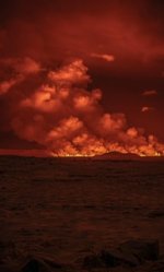
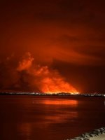
DISASTER Fairly large fissure volcano in Iceland tonight- Evacuating most of the peninsula
- Thread starter Warm Wisconsin
- Start date
Warm Wisconsin
Easy as 3.141592653589..
Warm Wisconsin
Easy as 3.141592653589..
2 minute video of the first helicopter to fly over the area
This is a potentially very bad situation. Could cut the island off from the international airport
TheSearcher
Are you sure about that?
Was that being discussed anywhere around here? It sure surprised me!
pauldingbabe
The Great Cat
That airport is still the NATO base as well?
Warm Wisconsin
Easy as 3.141592653589..
*** UPDATES ***
*** FISSURE NOW 4 KM ***
*** GRINDAVÍK ***
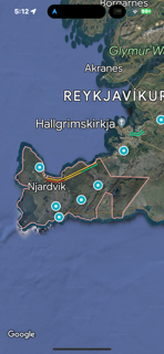
The fissure is about 4 kilometers long and could extend towards Grindavík. According to the latest measurements by the IMO, the seismic activity is moving south towards Grindavík. The measured activity is just east of the magma tunnel that formed on November 10. This development of the seismic activity, together with measurements from GPS devices, is an indication that the magma is moving to the southwest and the eruption could extend in the direction of Grindavík.
Source:
www.ruv.is
Warm Wisconsin
Easy as 3.141592653589..
Post in thread 'Intense earthquake swarm near Fagradalsfjall volcano, Iceland'Was that being discussed anywhere around here? It sure surprised me!
EQ - Intense earthquake swarm near Fagradalsfjall volcano, Iceland
Warm Wisconsin
Easy as 3.141592653589..
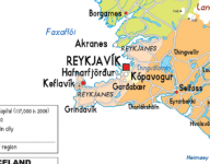
It look like the fissure is at Grindavik. The NATO base is at Keflavik, although there are a couple of NAVCOMSECGRU installations outside the base (or at least there were when I lived there for a year+ in the 1970s.)
View attachment 450889
The road from the capital to Keflavik is now closed. So both routes to the airport are closed now.
Warm Wisconsin
Easy as 3.141592653589..
The main road has been reopened. The fissure expansion seems to have stopped for the moment.
It’s expelling about 250 cubic meters a second.
Very large amount of lava.
The harmonic data is suggesting that there is significant magma being feed up directly from the mantle. This is a significant change from the last 3 eruptions in the last few years.
It’s expelling about 250 cubic meters a second.
Very large amount of lava.
The harmonic data is suggesting that there is significant magma being feed up directly from the mantle. This is a significant change from the last 3 eruptions in the last few years.
TheSearcher
Are you sure about that?
I had stopped watching it, as I thought it had been subsiding. I wonder if that recent big flare was more impactful than we thought.?Post in thread 'Intense earthquake swarm near Fagradalsfjall volcano, Iceland'
EQ - Intense earthquake swarm near Fagradalsfjall volcano, Iceland
Warm Wisconsin
Easy as 3.141592653589..
I had stopped watching it, as I thought it had been subsiding. I wonder if that recent big flare was more impactful than we thought.?
I have always discarded that idea. However, all 4 of the last Icelandic eruptions have happened right after solar flares and magnetic storms. Starting to consider this idea.
auxman
Ad eundum quo nemo ante iit...
From AlertsUSA...
Embassy Iceland issues volcano alert warning of an eruption north of Grindavik (26 miles SW of Reykjavik). Avoid area and monitor local news. More via email.
Background:
The ash cloud produced from the 2010 eruption of the Eyjafjallajökull volcano in Iceland resulted in the closure of the controlled airspace of many European countries and the cancellation of tens of thousands of flights worldwide.
Location: Grindavik, Reykjanes Peninsula, southwest Iceland
Event: The Icelandic Meteorological (Met) Office and news media reported a volcanic eruption started at 10:17 p.m., north of Sundhnúkur on Sundhnúkagýgaröðin about 2 miles (4 km) north of Grindavik, which is 26 miles (42 km) due southwest of Reykjavik, on the Reykjanes Peninsula, on December 18, 2023. Iceland Civil Protection is asking the public not to go to the site while responders assess the situation.
The Reykjanesbær Road to Keflavik Airport is closed at the main traffic circle in Hafnarfjörður, and all roads to Grindavik are closed. There are limited current impacts to flight operations at Keflavik Airport (KEF). Airlines will base their flight operation decisions on ash forecasts and other factors from the Icelandic Met Office and its partners. If you have pending travel plans, contact your airline or check their website for information.
U.S. citizens are advised to monitor local news and government websites for detailed information and to follow Civil Protection instructions.
Last edited:
Warm Wisconsin
Easy as 3.141592653589..
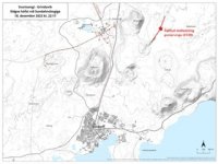
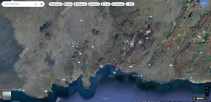
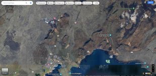
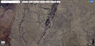
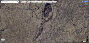
Definitely could! One of the eruptions in this area a few hundred years ago lasted almost 100 yearsLooking at a pre-eruption map, and heading about nearby magma flow, it looks like it could get quite a bit larger...
View attachment 450909View attachment 450910View attachment 450911View attachment 450912
Warm Wisconsin
Easy as 3.141592653589..
The fissure is now 5.5 km long!
The lava is now heading north and south, so both ways from the fissure.
The main road to the airport is now at risk of being overtaken within the next few days. They are debating about tourist evacuation. That has never happened in modern history.
The lava is traveling at 1-1.5 km per hour
The fountains in the live stream are a few hundred meters high.
Live stream

 www.youtube.com
Multi cam view

 www.youtube.com
The lava is now heading north and south, so both ways from the fissure.
The main road to the airport is now at risk of being overtaken within the next few days. They are debating about tourist evacuation. That has never happened in modern history.
The lava is traveling at 1-1.5 km per hour
The fountains in the live stream are a few hundred meters high.
Live stream

Grindavik (Fagradalsfjall) - Live from Iceland
Go to https://livefromiceland.is for more.
Multi cam view

Reykjanes multiview - Live from Iceland
Multiview of the evolving situation in Reykjanes. The town of Grindavík has been evacuated after magma intrusion was identified possibly reaching under it.Si...
Warm Wisconsin
Easy as 3.141592653589..
Here is my buddy’s you tube
He gets the best drone footage of Icelandic eruptions.
I am trying to get myself to Iceland before Christmas. No promises on this one like other eruptions. However, if I make it I will hike in to a high point to live stream.
Unfortunately my normal home base of grindavik is in the path of the lava so I still need to work that out.
He gets the best drone footage of Icelandic eruptions.
Loading…
youtube.com
I am trying to get myself to Iceland before Christmas. No promises on this one like other eruptions. However, if I make it I will hike in to a high point to live stream.
Unfortunately my normal home base of grindavik is in the path of the lava so I still need to work that out.
Warm Wisconsin
Easy as 3.141592653589..
Update from the Iclandic Met Office:
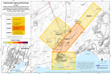
As of December 19, 2023, a volcanic eruption is ongoing on the Reykjanes Peninsula, specifically near Sundhnúksgígur, approximately 4 km northeast of Grindavík.
The eruption, which started about four hours ago, appears to be reducing in power based on observations from seismometers and GPS meters. This reduction in activity may suggest that the eruption is reaching equilibrium, although it does not necessarily indicate how long the eruption will last.
The eruption is occurring along the entire fissure, with the greatest force concentrated in the central area marked as "Zone 3" on the risk assessment map. The crack extends about 4-5 km in total length, with the northern end located just east of Stóra-Skógfell and the southern end east of Sundhnúk. The distance from the southern end to the edge of Grindavík is nearly 3 km.
Authorities, including the National Weather Service, are closely monitoring the situation and maintaining direct contact with civil defense and responders in the affected area. The trend of decreasing activity is noted to be a common occurrence at the beginning of eruptions on the Reykjanes Peninsula in recent years.
The National Weather Service will provide updates on the situation, and a consultation meeting of scientists is scheduled for the morning. The next news update is expected at 9 AM on December 19, 2023.
vedur.is

jward
passin' thru
Nahel Belgherze
@WxNB_
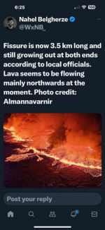
JUST IN: First aerial footage captured just minutes ago of the newly opened volcanic fissure near Grindavík, Iceland.
It is estimated to be about 3 km long!
View: https://twitter.com/WxNB_/status/1736894632720507214?s=20
@WxNB_
JUST IN: First aerial footage captured just minutes ago of the newly opened volcanic fissure near Grindavík, Iceland.
It is estimated to be about 3 km long!
View: https://twitter.com/WxNB_/status/1736894632720507214?s=20
packyderms_wife
Neither here nor there.
The eruption made the local news here in Iowa.
Warm Wisconsin
Easy as 3.141592653589..
Lava flow has slowed to about 20% of what it was last night. It may continue to decline or throw another fit. The magma stored is estimated to be 500,000 cubic meters and we know that magma is still entering from the mantle. BTW- It is very rare for magma to come directly from the mantle, even in Iceland.
The next 7 days estimates can be seen in the model below.
The eruption couldn’t have been placed in a better spot to not threaten anything. Almost mind blowing that an eruption of this size on the peninsula isn’t causing larger problems.
The next 7 days estimates can be seen in the model below.
The eruption couldn’t have been placed in a better spot to not threaten anything. Almost mind blowing that an eruption of this size on the peninsula isn’t causing larger problems.
Melodi
Disaster Cat
We did talk about this about two or three months ago when it looked like the Volcano might erupt, and the nearest town was evacuated. But volcanoes don't run on human time, and it quieted back down for a time, and they were building walls around the nuclear power station.
I didn't have time to read the whole article (I have company over), but I saw a headline that the power plant is now in danger, which means the lava may be too high for the wall to work if it goes there directly.
This is near the capitol, but so far, the capitol is not in danger.
There was a massive eruption closer to the capital, which Ben Franklin wrote about from board a ship going to France. He didn't even know it was Iceland. The sky had turned black and filled with smoke. It got to the outskirts of Rekayvick, and if the lava hadn't stopped, people would have had to flee into the sea. Nightwolf said it came very close to the entire Island being depopulated by Europeans for probably a hundred years or so. I think there was another big one in the Viking Age (I'm not sure), that also almost caused the European settlers to leave.
northern watch
TB Fanatic
I have always discarded that idea. However, all 4 of the last Icelandic eruptions have happened right after solar flares and magnetic storms. Starting to consider this idea.
Biggest solar flare in years temporarily disrupts radio signals on Earth
A NASA telescope has captured the biggest solar flare in years, which temporarily knocked out radio communication on EarthBy MARCIA DUNN AP aerospace writer
December 15, 2023, 10:13 AM

This photo provided by NASA’s Solar Dynamics Observatory captured this image of a solar flare, as seen in the bright flash in the upper right, on Thursday, Dec. 14, 2023. The sun spit out the huge flare at noon on Thursday, resulting in two hours of radio interference in the U.S. and other sunlit parts of the world. (NASA via AP)
CAPE CANAVERAL, Fla. -- A NASA telescope has captured the biggest solar flare in years, which temporarily knocked out radio communication on Earth.
The sun spit out the huge flare along with a massive radio burst on Thursday, causing two hours of radio interference in parts of the U.S. and other sunlit parts of the world. Scientists at the National Oceanic and Atmospheric Administration said it was the biggest flare since 2017, and the radio burst was extensive, affecting even the higher frequencies.
The combination resulted in one of the largest solar radio events ever recorded, Shawn Dahl of NOAA's Space Weather Prediction Center said Friday.
Multiple pilots reported communication disruptions, with the impact felt across the country, according to the space weather forecasting center. Scientists are now monitoring this sunspot region and analyzing for a possible outburst of plasma from the sun, also known as a coronal mass ejection, that might be directed at Earth. This could result in a geomagnetic storm, Dahl said, which in turn could disrupt high-frequency radio signals at the higher latitudes and trigger northern lights, or auroras, in the coming days.
The eruption occurred in the far northwest section of the sun. NASA’s Solar Dynamics Observatory caught the action in extreme ultraviolet light, recording the powerful surge of energy as a huge, bright flash. Launched in 2010, the spacecraft is in an extremely high orbit around Earth, where it constantly monitors the sun.
The sun is nearing the peak of its 11-year or so solar cycle. Maximum sunspot activity is predicted for 2025.
___
The Associated Press Health and Science Department receives support from the Howard Hughes Medical Institute’s Science and Educational Media Group. The AP is solely responsible for all content.

Biggest solar flare in years temporarily disrupts radio signals on Earth
A NASA telescope has captured the biggest solar flare in years, which temporarily knocked out radio communication on Earth
Last edited:
Warm Wisconsin
Easy as 3.141592653589..
The eruption has all but stopped
Only a small fraction of the magma made it to the surface
Chances of the magma reemerging in a different location in coming days/weeks is very high.
Only a small fraction of the magma made it to the surface
Chances of the magma reemerging in a different location in coming days/weeks is very high.

