WEATHER (CAT 3) Hurricane Douglas rapidly intensified into a major hurricane as it moves toward Hawaii

packyderms_wife

Neither here nor there.

Hurricane Douglas rapidly intensified into a major hurricane as it moves toward Hawaii
By Judson Jones, Derek Van Dam and Virginia Langmaid, CNN Meteorologists

Updated 1:28 PM ET, Thu July 23, 2020


(CNN)
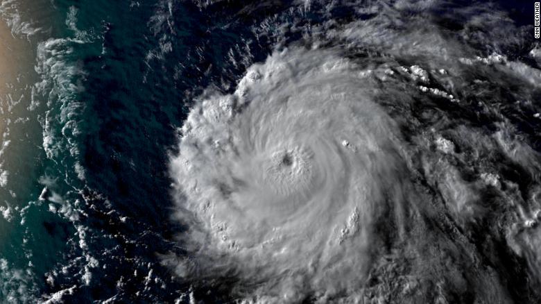
Douglas has rapidly intensified into a Category 3 hurricane on Thursday with wind speeds of 120 mph.

"The Hawaiian Islands should monitor the progress of Douglas," the National Hurricane Center (NHC) said.
The storm is over 1,000 miles east-southeast of Hilo, Hawaii, but is moving west-northwest toward the island chain.

The forecast track from the NHC has the storm approaching the islands on Sunday.

The storm is forecast to continue to strengthen today but expected to start weakening by Friday.

"Douglas is expected to be at or near hurricane intensity as it approaches the Hawaiian Islands on Sunday," the NHC says.

Rare for strong hurricanes to reach Hawaii
"It is fairly common for hurricanes to track towards Hawaii, but they usually dissipate or at least weaken considerably before impacting the islands," said Phil Klotzbach, a research scientist at Colorado State University. "For example, both Lane and Olivia impacted Hawaii in 2018. Also, in 2016, both Lester and Madeline threatened Hawaii."

200723082020-weather-hurricane-douglas-20200723-exlarge-169.jpg


Although a hurricane's effects on Hawaii can be severe, it is rare for major hurricanes to reach the shores of the island chain. For one, the Hawaiian Islands are a small plot of land amongst the largest ocean basin in the world making the statistical probability of a direct landfall very low.

Hawaii covers 6,423 square miles of land divided up among six main islands, making the chance of a direct landfall even less likely. Florida, by comparison, is a significantly easier target for hurricanes to strike as it covers more than 50,000 square miles

Douglas is expected to bring wind, rain and dangerous surf to Hawaii by the weekend, although it may be downgraded to a tropical storm by the time it reaches the islands.

There are other key weather features, like wind shear and dry air, that meteorologists look for to either steer storms away from Hawaii or weaken them dramatically before they reach the white sandy beaches of Honolulu.

One of the more influential atmospheric processes is a semi-permanent north Pacific high pressure system which often forces a detour of oncoming tropical systems. However, when that high pressure is weaker than normal or is broken down by an incoming trough, trouble can brew.

Slow start to the East Pacific hurricane season
In a season that has seen early storm formation in the Atlantic, the eastern Pacific has been slower for storm development than in previous years.

"Douglas has been upgraded to a 65-kt hurricane, the first of the 2020 eastern Pacific season," according to the hurricane center. "During the period of reliable records, this is the 4th latest date in which the first hurricane of the season has formed."

A slow Pacific hurricane season, especially when paired with an active Atlantic hurricane season, is a sign of a La Niña event, which forecasters have predicted could occur this year.

Under La Niña, global convection wind currents yield sinking air over the eastern Pacific, and rising air over the western Atlantic. Sinking air patterns increase wind shear, a sudden shift in wind direction, speed or both, which can rip apart hurricanes before they have a chance to grow.
 

packyderms_wife

Neither here nor there.
Tropical Weather Outlook Text
Tropical Weather Discussion​
ZCZC MIATWOEP ALL
TTAA00 KNHC DDHHMM

Tropical Weather Outlook
NWS National Hurricane Center Miami FL
1100 AM PDT Thu Jul 23 2020

For the eastern North Pacific...east of 140 degrees west longitude:

The National Hurricane Center is issuing advisories on Hurricane
Douglas, located over the far western portion of the basin.

1. An area of low pressure could form south of the southern coast of
Mexico over the weekend. Any development of this system is
expected to be slow to occur through early next week while it moves
generally west-northwestward.
* Formation chance through 48 hours...low...near 0 percent.
* Formation chance through 5 days...low...10 percent.

Forecaster Blake
 

Doomer Doug

TB Fanatic
Gee, Doomer Doug never had a hurricane named after him! I'm famous:shkr:It certainly doesn't look like it much of a hurricane. If I do it right it will wander around the central pacific and annoy the Squid, like I do here on timebomb, or freak out the plankton.

Tropical Tidbits is my go to site, along with National Hurricane Center. RT 13:00


Maryh

Veteran Member
Daughter on Oahu is prepping. Her thing is flooding off the mountain. She lives next to a little canal/ditch that flows into Kaneohe Bay and her patio wall has holes at the bottom that drain into the ditch and out to the bay. If the ditch fills up, the water will back up to her patio and back sliding doors. She has three. She bought one of those snake like tubes you fill with water to make a barrier. Think it might get its first big test soon because she sent a pic of the projected path from the Hawaii news and it goes right over her house.
 

packyderms_wife

Neither here nor there.
Daughter on Oahu is prepping. Her thing is flooding off the mountain. She lives next to a little canal/ditch that flows into Kaneohe Bay and her patio wall has holes at the bottom that drain into the ditch and out to the bay. If the ditch fills up, the water will back up to her patio and back sliding doors. She has three. She bought one of those snake like tubes you fill with water to make a barrier. Think it might get its first big test soon because she sent a pic of the projected path from the Hawaii news and it goes right over her house.

Thank you for the update, we have several members here that live in Hawaii I'm hoping they will post updates and soon.
 

Issy

Veteran Member
I'm on Maui. The Govenor was just on t.v......The models have split a bit now. Some have the eye going over Oahu, some have the eye going over Maui. They had pretty much been saying to expect it to be a tropical storm at landfall. Now they are saying a Cat 1. It is fast moving, unlike Lane of 2 years ago that sat and churned and finally just left. It is my understanding that the reason the Hawaiian Islands rarely get hurricanes (cyclones) is because our jet stream kind of catches them and chops them up. But right now the net stream has moved north (?) clearing a path for Douglas to slip right through. At any rate it doesn't much matter where the eye hits, we are all going to get wet!

Issy
 

Issy

Veteran Member
Heavy rains, big surf, and strong winds: Here’s what to expect from Douglas and when

By Ben Gutierrez | July 24, 2020 at 1:21 PM HST - Updated July 24 at 2:02 PM

HONOLULU, Hawaii (HawaiiNewsNow) - As Hurricane Douglas barrels toward the state, emergency management officials are urging residents to prepare now for potential impacts this weekend.

A hurricane watch is in effect for the the Big Island and Maui County along with surrounding coastal waters. This means at least tropical storm force winds of 39 to 73 mph are expected within 48 hours.

Damaging winds expected

The Central Pacific Hurricane Center said damaging winds may begin as early as Saturday night across parts of Maui and the Big Island. The winds could spread westward to the rest of the state on Sunday.

Here’s what Maui County and the Big Island should initially prepare for:

There could be some damage to roofing and siding materials, along with damage to porches, awnings, carports and sheds. A few buildings could have window, door and garage door failures. Mobile homes could be damaged, especially if they are unanchored. Unsecured, lightweight objects could become dangerous projectiles. Several large trees may be snapped or uprooted. This could happen in greater numbers where trees are shallow rooted. Fences and roadway signs may be blown over. Some roads will be impassible due to large debris, and more in urban or heavily wooded places. A few bridges, causeways and access routes will be impassable. Scattered power and communication outages are possible, especially in areas with above-ground lines.

Threat of heavy rain

A flash flood watch will also take effect Saturday evening through Monday for Maui County and the Big Island. Flooding rain will be possible as early as Saturday night on Maui and the Big Island, and the chance for flooding will increase for much of the state on Sunday.

The flood threat could persist for parts of the state into Monday.

Storm total rainfall of 6 to 10 inches, with some locally isolated areas to 15 inches, will be possible. The highest rainfall will favor windward areas, but leeweard areas could also experience flooding.

Major rainfall flooding may prompt evacuations and rescues. Rivers and tributaries may rapidly overflow their banks in multiple places. Small streams, creeks, canals, arroyos and ditches may become dangerous rivers. In mountain areas, destructive runoff may run quickly down valleys and increase the possibility of rockslides and mudslides. Flood control systems and barriers may become stressed. Flood waters can enter many structures in multiple communities, with some structures becoming uninhabitable or washed away. There are many areas where flood waters may cover escape routes. Streets and parking lots can become rivers of moving water with underpasses submerged. Driving conditions will become dangerous. Many road and bridge closures, with some roads and bridges weakened or washed out.

Dangerous surf and surge

Large swells arriving ahead of Douglas will produce dangerous surf along east and southeast-facing shores, especially on the Big Island and Maui.

Large and rough seas will build rapidly Saturday night and Sunday on exposed east and southeast facing shores and may produce damaging surf, significant beach erosion and overwash onto vulnerable coastal roads, especially during high tide.

Localized inundation with storm surge flooding will be possible, mainly along immediate shorelines and in low-lying spots, or an areas farther inland near where hgiher surge waters move ashore. Sections of near-shore roads and parking lots will become overspread with surge water. Driving conditions will be dangerous in places where surge water covers the road. Expect moderate beach erosion. Heavy surf will also breach sand dunes, especially in usually vulnerable locations. Strong rip currents can occur. Minor to locally moderate damage can occur to marinas, docks, boardwalks and piers. A few small craft can be broken away from moorings.


packyderms_wife

Neither here nor there.
Update from about 25 minutes ago.

Hurricane Douglas system still churning toward islands


2D576B70-6946-4C13-B74A-B06243D5CA8B.png


Hurricane Douglas effects could be felt as early as Saturday night, including heavy rain and wind, on Maui with hurricane watches and tropical storm warnings up for the county, the National Weather Service said in its 8 a.m. Saturday update.


Douglas remained a Category 2 hurricane with maximum sustained winds of 100 mph. The hurricane was 495 east southeast of Kahului and 460 miles east southeast of Hana and moving west northwest at 18 mph.

The system is forecast to weaken as it moves over cooler waters and buffeted by vertical wind shear, the Central Pacific Hurricane Center said. On its current forecast track, Douglas’ center will move near or over the islands as a weakened hurricane or strong tropical storm Sunday.

A forecast track has Douglas passing near or over Maui island early Sunday afternoon. Maximum wind speeds still are expected to be in the 75 to 80 mph range.

Based on this forecast, the National Weather Service posted a Tropical Storm Warning for Hawaii and Maui Counties. This means that tropical storm conditions are expected within 36 hours.

A Hurricane Watch means that hurricane conditions are possible within the next 36 to 48 hours.

Other warnings and advisories include:
A high surf warning for east-facing shores of Maui and Molokai through 6 a.m. Monday. Douglas will produce a large swell with large breaking waves of 15 to 25 feet by late Saturday or Sunday. Combined with higher than predicted ocean levels, surf and storm surge significant beach erosion and flooding of low lying roads are possible.

Flash flood watch will be in effect from Sunday to Monday morning. Rainfall accumulations could be 5 to 10 inches with locally higher amounts to 15 inches.
 

packyderms_wife

Neither here nor there.
I used to live in the Kaneohe area.
Housing is not always the most solidly built.
Prayers and hugs for those affected.

I have a friend who lives not far from there, she's living in a house she's building herself... I'm praying she does well in this hurricane.
 

Maryh

Veteran Member
Just talked to daughter and son-in-law. They are trying to get all their stuff secured now. They have two outrigger canoes and paddle boards hanging on the side wall of their studio. Don't know where they will put them, probably drag them into the main house. Son-in-law is Coast Guard and said he worries most about the tidal surge that may come afterward. There house sits on K Bay and they just tore the old one down to the walls and built it up to two stories. Haven't even had the final inspection yet. They put extra reinforcements in the trusses so hopefully it will stay together.
 

packyderms_wife

Neither here nor there.
Just talked to daughter and son-in-law. They are trying to get all their stuff secured now. They have two outrigger canoes and paddle boards hanging on the side wall of their studio. Don't know where they will put them, probably drag them into the main house. Son-in-law is Coast Guard and said he worries most about the tidal surge that may come afterward. There house sits on K Bay and they just tore the old one down to the walls and built it up to two stories. Haven't even had the final inspection yet. They put extra reinforcements in the trusses so hopefully it will stay together.

Thank you for the update, not seeing much news on this hurricane at the moment.
 

vessie

Has No Life - Lives on TB
Phew! Got my homeowners, flood and hurricane insurance all paid up!

I have a home on the waterfront in Kapa'a Kauai and Just had new hurricane sliding doors installed.

I'm just praying that my friend Candace who lives right on the Wailua river south of town down the street from the old Coco Palms, is going to be ok. I gave her 2 Waterbobs and some other things last March when I was on island, and her house is on stilts, but still, I worry about her. V
 

Maryh

Veteran Member
Vessie, What do hurricane sliding doors look like? Maybe daughter should replace her four.
 

vessie

Has No Life - Lives on TB
Vessie, What do hurricane sliding doors look like? Maybe daughter should replace her four.
Like regular ones, just google "Hurricane rated sliding glass doors".

And if I was your daughter, I would get big wide rolls of plastic sheeting and snug it up against the perimeter of the home And Then lay the sand bags etc. on top of that so it will create a kind of 'seal' against the water.

My veterinarian did that at his clinic before we had the big floods in the Snoqualmie Valley back in the spring of 2009 after the heavy snows melted and left the whole valley under water.

Show her this... Flood Wraps and Temporary Shields.


FloodWrap


"Using Plastic Sheeting to Keep Floodwater Out

Plastic sheeting is a versatile flood barrier. Using plastic sheeting in a sandbag levee improves the levee’s performance significantly.
Dry floodproofing seals a building permanently so water will not enter. Plastic sheeting can be used against the outside walls to provide similar temporary protection. The plastic can be supported on structures built out from the building, so landscaping around the building is not displaced and the building does not feel the force of water on its walls.
It is necessary to block doors, windows, small drains and other openings and to prevent sewer backup when you make a temporary flood barrier with plastic sheeting." V
 

Issy

Veteran Member
Douglas is now a Cat 1 per 11a HST update. We won't get another update till 5p HST.

Last night at 11p and again at midnight we got recorded calls on our landlines warning there may be flash flooding with the coming cyclone. Really?! And they had to wait til freaking midnight to call us???? Have not had a call since. I guess we should be glad it wasn't a recording saying an incoming missile would be landing on land or in the sea again.

Issy
 

packyderms_wife

Neither here nor there.
Douglas is now a Cat 1 per 11a HST update. We won't get another update till 5p HST.

Last night at 11p and again at midnight we got recorded calls on our landlines warning there may be flash flooding with the coming cyclone. Really?! And they had to wait til freaking midnight to call us???? Have not had a call since. I guess we should be glad it wasn't a recording saying an incoming missile would be landing on land or in the sea again.

Issy

Thank you for the update.
 

Issy

Veteran Member
A good and bad thing for the islands right now is we have much fewer tourists to shelter. But also have to deal with covid in the shelters. Yesterday the Red Cross was calling for volunteers. They said the usual number of volunteers is down 75%.
 

Issy

Veteran Member
5pm update. A tiny nudge north. It did not weaken. Still Cat 1. Eye will not hit Maui. Goes right over. Cone does involve Maui. Next update 11p. Storm is healthy pressure 982. Looks like Big Island will be missed.
 
Top