
You are using an out of date browser. It may not display this or other websites correctly.
You should upgrade or use an alternative browser.
You should upgrade or use an alternative browser.
Story Aunt Gus & Little Bear's Great Adventure Book 1 (Complete)
- Thread starter Kathy in FL
- Start date
July 8th – North Rim and South Rim (Part 1)
Weather: 65/38
Driving Route:

Today could have ended in disaster, all for my lack of planning, or at least my thinking therefore it must be so. Well, maybe disaster is too strong a word, but it certainly would have been a struggle. My eyes were bigger than my stomach, only not about food. I forgot. Well not exactly that either. And none of this is about food no matter how it sounds. I’m almost too tired to explain myself. Maybe if I start at the beginning. That should keep the hamster at bay.

After all the reading I’ve done on the national parks, for sure no trip to Yellowstone would be complete without a visit to the Grand Canyon of the Yellowstone River, a deep chasm with two beautiful waterfalls. All the guidebooks say it. All of the online sites say it. All the blogs and vlogs I’ve read say it. And you can just imagine what the people that have been there say about it. And after today I’ll add my agreement to that.
You get numerous memorable views of the canyon by hiking along North Rim Trail, which stretches 3.8 miles over a paved and unpaved path crossing the northwest wall of the Grand Canyon of the Yellowstone River (with just 250 feet of elevation change). But, after two days of long hikes I had originally planned to drive the North and South rims, stopping at the various pull outs and just walking to the views.
Oh … my … freaking … gosh. It was obvious, even starting as early as we did, that crowds and traffic was going to be more than a little problematic. I can’t swing the Ark into just any little space so I decided we’d hike the North Rim instead after all.

Some sections of North Rim Trail parallel North Rim Drive, the road that allows visitors to drive right up to some of the north rim’s exceptional overlooks. The road makes it easy to hike North Rim Trail in segments, our original plan, but a straight through hike wasn’t beyond our capabilities or time so that’s what we did instead. Away from the road, North Rim Trail crosses pine forests perched atop precarious canyon walls. That description comes from one of the guidebooks and I can’t top it so I’ll use it. The trail connects several named and noteworthy viewpoints while passing unnamed views that will stop you in your tracks, and that’s a fact.

At it’s northeast end, North Rim Trail gets off to a stunning start at Inspiration Point, and then runs southwest past the Upper Falls of Yellowstone Falls, reaching a bridge that crosses the Yellowstone River for the south rim. Persistent hikers can continue up South Rim Trail for the opposing view of the Grand Canyon of the Yellowstone. Hikers with less time can exclude the final southwestern leg of North Rim Trail, which follows a calmer section of the Yellowstone River upstream from the canyon, and reduce the hike to the 3.3 miles between Inspiration Point and Upper Falls. I didn’t want to miss anything so we left it in. Arrogance 101, or maybe Stupid 101, not sure which is a better descriptor. For me it would have been fine and dandy to make it a 6.6 to 7.6-mile round trip hike. I didn’t put enough thought into it for Benny’s sake. Still honestly feel like kicking my own butt over it.
Starting from the top of the stairs leading to the panoramic views at Inspiration Point, North Rim Trail parts with the road and crosses a forest of lodgepole pines. The forest is quiet, and surprisingly peaceful considering how close it is to the dangerous canyon wall. Freaked me out a little but Benny understands “the rules” and so long as I kept him to the inside of the trail and there weren’t too many people it turned out to be less nerve-wracking than I was worried it was going to be when I got my first glimpse of the trail
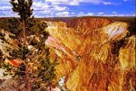
After curving through the forest, the trail passes directly along the edge of the canyon, where just a few feet separate the dirt path from a sheer thousand-foot drop to the Yellowstone River. Gak. Incredible but geez Louise. The views are beautiful and daunting. A created a new word … unthesaurusable. There’s just no describing the views with any adequacy. You view an acute V-shaped canyon with bright orange, yellow, and pink walls surrounding a river of swift dark blue water that are capped by powerful white rapids. It is only three-quarter of a mile across the chasm to the south rim but even that is deceptive. Starting at the Upper Falls of Yellowstone Falls, the Yellowstone River carves a deep 20-mile gash across the pine-covered landscape, and the North Rim Trail delivers exceptional views of the most stunning section of the canyon.

After one and a third miles you hit pavement and arrive at Grand View Point, the next named lookout along the trail. Switching from dirt to concrete was absurdly welcome given the crowds we were hiking in. North Rim Drive parallels the trail as you continue to hike past Osprey Point to a spur trail to Lookout Point and Red Rock Point (1.7 miles from Inspiration Point). The guidebook said the view from Lookout Point should not be missed, so we turned left on a 0.15-mile round trip spur to enjoy the overlook. It was a postcard view of Lower Falls that we took plenty of pictures of. We also hiked the 0.75-mile round trip spur down to Red Rock Point for a closer look at the 308-foot tier of Yellowstone Falls. More pictures. Lots of more pictures. We also took some selfies (front and back) in a couple of lulls of the crowds.

Continuing on North Rim Trail, we passed more views of Lower Falls. After North Rim Drive curves away from the trail, there was a spur trail heading down to the brink of Lower Falls. This difficult addition to the trail comes 2.5 miles from Inspiration Point and requires hikers descend 600 feet over 3/8 of a mile to reach the Lower Falls. I suppose we could have been satisfied with the views from the top of the trail but … nah! Benny and I both wanted an up close and personal view of Lower Falls and we still had lots of wiggle energy to expend. Coming back up the spur trail wasn’t the easiest hiking we’ve ever done but it was worth it for the views we got.

At that point North Rim Trail dips across a depression in the side of the canyon caused by Cascade Creek. We crossed the creek and headed uphill to a view looking back toward Crystal Falls, a 130-foot drop through pines toward the Yellowstone River. The trail emerges from the woods once more at the parking area for the Brink of the Upper Falls Trail. Yep, more mileage on our boots.
The Brink of Lower Falls Trail switchbacks steeply down a mostly forested section of the canyon to an observation platform perched at the top of the Lower Falls of the Yellowstone. Here the river plunges 308 feet into the heart of the canyon with the sound of thunder. It was a spectacular view.
From the Brink of Lower Falls parking area, the trail (which technically doesnt begin until the end of the first switchback) drops more than 300 feet in 0.4 miles. Yeah, it was a little steep said the hamster in sublime understatement. A very popular trail, it was crowded but enjoyable. What made it even more crowed was the direction of the one-way North Rim Road was changed mid-morning making this the first stop on the road.
Reading from a small guidebook I carried I told Benny that in 1887, Owen Wister, gathering stories and inspiration later used in his classic western novel, The Virginian, described Lower Falls this way: "This is the most beautiful thing I have ever seen. The water falls . . . 300 feet into a caldron of rock . . . the spray floats out into a rainbow that melts away into many-colored moss, until you cannot discern which is moss and which rainbow."
“One of your grandfather’s favorite things to do was read westerns and historical novels in his down time … when raising me allowed him any down time. It was how he relaxed, and The Virginian was one of his all-time favs. Your dad gave him a First Edition of the book for his birthday the year after he completed Basic Training. And one day, when you are older, I’ll make sure you have that book as well. Right now it is in storage in Jacksonville.”
“I can really have it?” he asked surprised.
“Sure. And when you are old enough maybe we can read it together. Dad would sometimes read it to me … when I managed to sit still long enough.”
Benny snickered at that because he’s heard stories his entire life about my sometimes less than stellar exploits as a kid. But at that point we wound up having to put all our efforts and attention into the trail ahead of us.

Many visitors stop there thinking it’s a short way to the viewpoint. More than a few were unprepared for how steep and difficult trail the trail turns out to be. It is a slow hike down and an even slower hike back up. But the views at the bottom are amazing, making it a must-do hike for those capable of it. And speaking of capable … on our way back up I had to play mule for a Dad that was overwhelmed when both of his kids pooped out and refused to budge. I took the younger of the two, and much to her two-year-old delight she used my braids as reins. I haven’t had to deal with “giddy up horsey” since Benny was that age, and I was pretty not thrilled to have her screeching in my ear the whole way up, but sometimes you just gotta help a stranger out.
Back at the top I turned over Little Miss Hot Mess in need of a Pull-Up changed to “Grammy” and wanted to stick a finger in my ear to make sure all the squeals were out. The Dad insisted on getting me a bottle of water and saying thank you.
“Seriously. Not a problem.”
“In your opinion,” he said. “I need my head examined. Next time I read the sign before I start the trail.”
I chuckled. “Been there myself. Just look at it this way. Nap time will be a lot easier.”
“Oh now there’s a silver lining.”
I finally got shed of the nice people and Benny and I continued on where, once out of earshot, he made a comment along the lines of let’s not rescue so many people. Snicker. Snort. I had begun to feel the same way and admitted next time hopefully we can leave it to the park rangers or someone else can be the Good Samaritan. Which then necessitated me telling him the parable of the Samaritan, explaining it, and then both of us saying, “Oh well, maybe we might rescue someone again. Just hope it doesn’t have to be today.”
Passed the parking lot we continued on North Rim Trail, quickly reaching the mandatory turnoff to the stone viewing platform at the top of the 109-foot waterfall that sets off the Grand Canyon of the Yellowstone.
Yellowstone Falls is split into two tiers separated by a quarter mile. Due to a bend in the river, the longer 308-foot Lower Falls is not visible from the Upper Falls. Still there is a heck of a lot to see, especially the violent plunge of the water that begins from the Brink of the Upper Falls. The amount of water flowing over Upper Falls varies throughout the year. It is estimated that a minimum of 5,000 gallons of water flow over the waterfall each second during the dry fall season, and over 60,000 gallons during peak spring runoff. Despite how violent the waterfall looks, there are calming rainbows that appear in the swirling mist. There’s a life lesson in there for people that look is what Grandmother Barry would have said.

Beyond the Brink of the Upper Falls, North Rim Trail continues another 0.4 mile along the Yellowstone River up to a bridge (Chittenden Bridge) crossing over to the south side of the canyon. This is where I lost my commonsense, or so it appears in hindsight.
The guidebook said if your legs are feeling strong, you can hike up South Rim Trail to breathtaking overlooks like Point Sublime and Artist Point, or make an impressive staircase descent to the base of Upper Falls on Uncle Tom’s Trail. I looked at the traffic on the roads, thought about having to hike back to where we started only to make our way through the traffic and fight for a spot in the parking lots, and went, “Nah! We can hike it. We be tough enough.” Oh boy.
Weather: 65/38
Driving Route:
Today could have ended in disaster, all for my lack of planning, or at least my thinking therefore it must be so. Well, maybe disaster is too strong a word, but it certainly would have been a struggle. My eyes were bigger than my stomach, only not about food. I forgot. Well not exactly that either. And none of this is about food no matter how it sounds. I’m almost too tired to explain myself. Maybe if I start at the beginning. That should keep the hamster at bay.
After all the reading I’ve done on the national parks, for sure no trip to Yellowstone would be complete without a visit to the Grand Canyon of the Yellowstone River, a deep chasm with two beautiful waterfalls. All the guidebooks say it. All of the online sites say it. All the blogs and vlogs I’ve read say it. And you can just imagine what the people that have been there say about it. And after today I’ll add my agreement to that.
You get numerous memorable views of the canyon by hiking along North Rim Trail, which stretches 3.8 miles over a paved and unpaved path crossing the northwest wall of the Grand Canyon of the Yellowstone River (with just 250 feet of elevation change). But, after two days of long hikes I had originally planned to drive the North and South rims, stopping at the various pull outs and just walking to the views.
Oh … my … freaking … gosh. It was obvious, even starting as early as we did, that crowds and traffic was going to be more than a little problematic. I can’t swing the Ark into just any little space so I decided we’d hike the North Rim instead after all.
Some sections of North Rim Trail parallel North Rim Drive, the road that allows visitors to drive right up to some of the north rim’s exceptional overlooks. The road makes it easy to hike North Rim Trail in segments, our original plan, but a straight through hike wasn’t beyond our capabilities or time so that’s what we did instead. Away from the road, North Rim Trail crosses pine forests perched atop precarious canyon walls. That description comes from one of the guidebooks and I can’t top it so I’ll use it. The trail connects several named and noteworthy viewpoints while passing unnamed views that will stop you in your tracks, and that’s a fact.
At it’s northeast end, North Rim Trail gets off to a stunning start at Inspiration Point, and then runs southwest past the Upper Falls of Yellowstone Falls, reaching a bridge that crosses the Yellowstone River for the south rim. Persistent hikers can continue up South Rim Trail for the opposing view of the Grand Canyon of the Yellowstone. Hikers with less time can exclude the final southwestern leg of North Rim Trail, which follows a calmer section of the Yellowstone River upstream from the canyon, and reduce the hike to the 3.3 miles between Inspiration Point and Upper Falls. I didn’t want to miss anything so we left it in. Arrogance 101, or maybe Stupid 101, not sure which is a better descriptor. For me it would have been fine and dandy to make it a 6.6 to 7.6-mile round trip hike. I didn’t put enough thought into it for Benny’s sake. Still honestly feel like kicking my own butt over it.
Starting from the top of the stairs leading to the panoramic views at Inspiration Point, North Rim Trail parts with the road and crosses a forest of lodgepole pines. The forest is quiet, and surprisingly peaceful considering how close it is to the dangerous canyon wall. Freaked me out a little but Benny understands “the rules” and so long as I kept him to the inside of the trail and there weren’t too many people it turned out to be less nerve-wracking than I was worried it was going to be when I got my first glimpse of the trail
After curving through the forest, the trail passes directly along the edge of the canyon, where just a few feet separate the dirt path from a sheer thousand-foot drop to the Yellowstone River. Gak. Incredible but geez Louise. The views are beautiful and daunting. A created a new word … unthesaurusable. There’s just no describing the views with any adequacy. You view an acute V-shaped canyon with bright orange, yellow, and pink walls surrounding a river of swift dark blue water that are capped by powerful white rapids. It is only three-quarter of a mile across the chasm to the south rim but even that is deceptive. Starting at the Upper Falls of Yellowstone Falls, the Yellowstone River carves a deep 20-mile gash across the pine-covered landscape, and the North Rim Trail delivers exceptional views of the most stunning section of the canyon.
After one and a third miles you hit pavement and arrive at Grand View Point, the next named lookout along the trail. Switching from dirt to concrete was absurdly welcome given the crowds we were hiking in. North Rim Drive parallels the trail as you continue to hike past Osprey Point to a spur trail to Lookout Point and Red Rock Point (1.7 miles from Inspiration Point). The guidebook said the view from Lookout Point should not be missed, so we turned left on a 0.15-mile round trip spur to enjoy the overlook. It was a postcard view of Lower Falls that we took plenty of pictures of. We also hiked the 0.75-mile round trip spur down to Red Rock Point for a closer look at the 308-foot tier of Yellowstone Falls. More pictures. Lots of more pictures. We also took some selfies (front and back) in a couple of lulls of the crowds.
Continuing on North Rim Trail, we passed more views of Lower Falls. After North Rim Drive curves away from the trail, there was a spur trail heading down to the brink of Lower Falls. This difficult addition to the trail comes 2.5 miles from Inspiration Point and requires hikers descend 600 feet over 3/8 of a mile to reach the Lower Falls. I suppose we could have been satisfied with the views from the top of the trail but … nah! Benny and I both wanted an up close and personal view of Lower Falls and we still had lots of wiggle energy to expend. Coming back up the spur trail wasn’t the easiest hiking we’ve ever done but it was worth it for the views we got.
At that point North Rim Trail dips across a depression in the side of the canyon caused by Cascade Creek. We crossed the creek and headed uphill to a view looking back toward Crystal Falls, a 130-foot drop through pines toward the Yellowstone River. The trail emerges from the woods once more at the parking area for the Brink of the Upper Falls Trail. Yep, more mileage on our boots.
The Brink of Lower Falls Trail switchbacks steeply down a mostly forested section of the canyon to an observation platform perched at the top of the Lower Falls of the Yellowstone. Here the river plunges 308 feet into the heart of the canyon with the sound of thunder. It was a spectacular view.
From the Brink of Lower Falls parking area, the trail (which technically doesnt begin until the end of the first switchback) drops more than 300 feet in 0.4 miles. Yeah, it was a little steep said the hamster in sublime understatement. A very popular trail, it was crowded but enjoyable. What made it even more crowed was the direction of the one-way North Rim Road was changed mid-morning making this the first stop on the road.
Reading from a small guidebook I carried I told Benny that in 1887, Owen Wister, gathering stories and inspiration later used in his classic western novel, The Virginian, described Lower Falls this way: "This is the most beautiful thing I have ever seen. The water falls . . . 300 feet into a caldron of rock . . . the spray floats out into a rainbow that melts away into many-colored moss, until you cannot discern which is moss and which rainbow."
“One of your grandfather’s favorite things to do was read westerns and historical novels in his down time … when raising me allowed him any down time. It was how he relaxed, and The Virginian was one of his all-time favs. Your dad gave him a First Edition of the book for his birthday the year after he completed Basic Training. And one day, when you are older, I’ll make sure you have that book as well. Right now it is in storage in Jacksonville.”
“I can really have it?” he asked surprised.
“Sure. And when you are old enough maybe we can read it together. Dad would sometimes read it to me … when I managed to sit still long enough.”
Benny snickered at that because he’s heard stories his entire life about my sometimes less than stellar exploits as a kid. But at that point we wound up having to put all our efforts and attention into the trail ahead of us.
Many visitors stop there thinking it’s a short way to the viewpoint. More than a few were unprepared for how steep and difficult trail the trail turns out to be. It is a slow hike down and an even slower hike back up. But the views at the bottom are amazing, making it a must-do hike for those capable of it. And speaking of capable … on our way back up I had to play mule for a Dad that was overwhelmed when both of his kids pooped out and refused to budge. I took the younger of the two, and much to her two-year-old delight she used my braids as reins. I haven’t had to deal with “giddy up horsey” since Benny was that age, and I was pretty not thrilled to have her screeching in my ear the whole way up, but sometimes you just gotta help a stranger out.
Back at the top I turned over Little Miss Hot Mess in need of a Pull-Up changed to “Grammy” and wanted to stick a finger in my ear to make sure all the squeals were out. The Dad insisted on getting me a bottle of water and saying thank you.
“Seriously. Not a problem.”
“In your opinion,” he said. “I need my head examined. Next time I read the sign before I start the trail.”
I chuckled. “Been there myself. Just look at it this way. Nap time will be a lot easier.”
“Oh now there’s a silver lining.”
I finally got shed of the nice people and Benny and I continued on where, once out of earshot, he made a comment along the lines of let’s not rescue so many people. Snicker. Snort. I had begun to feel the same way and admitted next time hopefully we can leave it to the park rangers or someone else can be the Good Samaritan. Which then necessitated me telling him the parable of the Samaritan, explaining it, and then both of us saying, “Oh well, maybe we might rescue someone again. Just hope it doesn’t have to be today.”
Passed the parking lot we continued on North Rim Trail, quickly reaching the mandatory turnoff to the stone viewing platform at the top of the 109-foot waterfall that sets off the Grand Canyon of the Yellowstone.
Yellowstone Falls is split into two tiers separated by a quarter mile. Due to a bend in the river, the longer 308-foot Lower Falls is not visible from the Upper Falls. Still there is a heck of a lot to see, especially the violent plunge of the water that begins from the Brink of the Upper Falls. The amount of water flowing over Upper Falls varies throughout the year. It is estimated that a minimum of 5,000 gallons of water flow over the waterfall each second during the dry fall season, and over 60,000 gallons during peak spring runoff. Despite how violent the waterfall looks, there are calming rainbows that appear in the swirling mist. There’s a life lesson in there for people that look is what Grandmother Barry would have said.
Beyond the Brink of the Upper Falls, North Rim Trail continues another 0.4 mile along the Yellowstone River up to a bridge (Chittenden Bridge) crossing over to the south side of the canyon. This is where I lost my commonsense, or so it appears in hindsight.
The guidebook said if your legs are feeling strong, you can hike up South Rim Trail to breathtaking overlooks like Point Sublime and Artist Point, or make an impressive staircase descent to the base of Upper Falls on Uncle Tom’s Trail. I looked at the traffic on the roads, thought about having to hike back to where we started only to make our way through the traffic and fight for a spot in the parking lots, and went, “Nah! We can hike it. We be tough enough.” Oh boy.
Attachments
July 8th – North Rim and South Rim (Part 2)
The guidebook said if your legs are feeling strong, you can hike up South Rim Trail to breathtaking overlooks like Point Sublime and Artist Point, or make an impressive staircase descent to the base of Upper Falls on Uncle Tom’s Trail. I looked at the traffic on the roads, thought about having to hike back to where we started only to make our way through the traffic and fight for a spot in the parking lots, and went, “Nah! We can hike it. We be tough enough.” Oh boy.
The South Rim Trail began on the south side of Chittenden Bridge. It follows the Yellowstone River 1.8 miles downstream, past impressive views of both Upper Falls and Lower Falls of the Yellowstone, and ends near spectacular Artist Point. I mean how hard could that be and surely it wouldn’t add too much distance onto our hike for the day. And really, it would save “us” the aggravation of the traffic and crowds. Suuuuuure. Talk about your self-serving blindness.

Hiking was pleasant along the first stretch of the trail through lodgepole pine and five-needled limber pine. There were intermittent views of the river as it churns away heading for the Falls. It didn’t take long for us to reach where the trail opens up and provides good views of Upper Falls. About 0.6 miles from Chittenden Bridge, the Upper Falls Viewpoint is reached. There were definitely more eople at the viewpoint than on the trail but it is still the best place to view the Upper Falls. A sign-thingie read, “The falls spill 109 feet over a dense rhyolite lava flow that is resistant to erosion. Immediately downstream, a much softer rhyolite, containing larger amounts of volcanic glass, was more easily eroded by the river.”
As we continued along the South Rim Trail, we could see through the trees to the opposite side of the canyon. Cascading through the lodgepoles, down the far wall, was a pretty water 129-foot water feature called Crystal Falls.
About 0.9 miles from Chittenden Bridge, we reached the turnoff for Uncle Tom's Trail to the bottom of the canyon. This trail uses a series of steel stairways to descend more than 300 feet in 0.3 miles.

The guidebooks are all correct. Uncle Tom’s Trail in Yellowstone National Park is a unique experience and a trail rich in history. A sign along the trail explained how the one-of-a-kind staircase came to be. Shortly after 1900, “Uncle Tom” Richardson took visitors down into the Canyon along this trail. Originally with 528 steps and rope ladders, it now descends 328 steps or about 3/4 of the way down into the Canyon for an excellent view of the Lower Falls. Thank goodness the trail is different today though it is still very, very steep.
Uncle Tom’s Trail is only a “trail” in the same way you say it is a hike when you take the stairs instead of the elevator in the Empire State Building. This “trail” consists of over 300 steel steps built down the south wall of the Grand Canyon of the Yellowstone. The up-close views of Lower Falls are, well there are no words, or at least none that are adequate. I think I need a new thesaurus. It is a 0.7-mile round trip hike that has 500 feet of elevation loss down and the same again on the way back up. Pretty crazy as such experiences go and with a five-year-old in tow more than just a little crazier. I didn’t have to play mule like with the two-year-old but only because we took plenty of breaks going back up. And the breaks weren’t just for Benny’s sake if I’m being honest.
We started with some stair-free hiking toward the canyon’s edge, reaching South Rim Trail a tenth of a mile from the parking lot. We turned right, and followed the sign for Uncle Tom’s Trail toward another junction fifty yards ahead. Then you turn left to start down Uncle Tom’s Trail. From my first view of the stairs, my brain hamster was tapping my shoulder and asking if I knew for sure what I was getting into. It’s one of the few times I should have listened to the rodent rather than ignoring it.
After another fifty yards, we reached a third junction with a spur trail breaking off to the left toward an overlook. The viewpoint, another fifty yards up a level spur, offers a nice view down the canyon away from the waterfall. We actually stopped there coming back up as well to have a good excuse to catch our breath after climbing those 328 steps.

Below this last junction, Uncle Tom’s Trail stops being a walking trail and becomes a series of steep steps made of perforated steel (that way you can look straight through the stairs for an extra dose of vertigo /snark). There is a railing to grab hold of on the descent into the canyon but it was slick with people’s perspiration. Gross. When we got to the bottom one of the first things I did was hand Benny a wet nap to clean his hands with. I was scrubbing my own for a fact.

The staircase wraps down the rocky canyon wall, reaching a viewing platform in a cluster of pines just below the 308-foot waterfall framed by jagged orange rock walls. The waterfall creates a dense mist as it crashes to the bottom of the canyon. Water droplets collect on the sides of the canyon, creating streams that run back into the river. The bottom of Uncle Tom’s Trail provides an intense view of Lower Falls. You can actually feel the power of the falls through the viewing platform and from the sound the roaring water gives off. The platform is crowded, both from people admiring the falls and because not everyone is thrilled with starting the return trek to the top.

Going back up was at least as challenging as coming down had been. Both Benny and I needed a break when we finally got back to the parking lot. That’s where we learned that the trail had been closed for years and had only recently reopened with all re-built staircases and multiple call boxes in case of emergencies. Wahoo and all that. We definitely saw some near emergencies as people stumbled and would have fallen if not for all the people around catching them and preventing serious injury. I mean if you aren’t physically up for the activity you shouldn’t attempt it. Those signs up at the top of the trail are there for a reason. And betcha buncha bucks more people wished they’d taken them more seriously.
Although heavily traveled, the next section of the South Rim Trail, between Uncle Tom's Trail and Artist Point, is truly spectacular. In the words of one of the abundant sign-thingies, “Picturesque views of the canyon and Lower Falls await you each time you break out of the trees. As you continue to Artist Point, take a moment to contemplate how this magnificent canyon and falls were created. Hundreds of thousands of years before the canyon was formed, an ancient thermal basin existed. The hot waters altered and weakened the hard rhyolite lava in the area, allowing the river to cut this deep canyon. Today, Lower Falls tumbles 308 feet over a hard, thermally-unaltered rhyolite flow.”
Beyond that point, the crowds were smaller as the trail continued at the Ribbon Lake trailhead. Shortly after, the trail left the paved path and became a singletrack trail. It wasn’t completely empty of people however and we had company on the first 0.6 miles of this trail. But after that, a steep 200-foot climb discouraged all but serious hikers.
The dirt trail ran along the canyon rim with ever-changing views of the canyon and the Yellowstone River far below. The walls were a colorful mixture of red, white, yellow, and every color in between. Rock spires added to the surreal landscape while the Yellowstone River continued its whitewater fury.

Approximately 0.6 miles beyond Artist Point, the trail to Ribbon Lake is passed. To reach Sublime Point we continued straight along the rim trail another 0.7 miles to the trail's end. Here the colors faded and the trees began to take over the canyon. On the other hand, the canyon was deeper and stood well over 1,000 feet above the river.
Although it affords no views of the falls, a few more great overlooks dot the trail until it terminates at a point surrounded by tall trees with limited views called Point Sublime. We turned around there and headed back to Artist’s Point.

It was our plan … my plan … to walk all the way back to the North Rim but turns out Yellowstone is testing out a free shuttle system of its own in a few select locations. We hitched a ride on the tram and took it all the way back to our start at North Rim. Wow did that save us some time and Benny certainly enjoyed the rest, nearly falling asleep as the tram bumped along between stops.
I added it up and the North Rim portion of today’s hike was 3.2 miles point to point plus some extra miles to go off trail to the various spurs to lookout points and the South Rim portion was over 2 miles point to point, plus the mile for Uncle Tom’s Trail, plus more for the stretch beyond Artist’s point that we walked there and back. Like I said, I had originally just meant to drive the two rim roads, stop and get out at each point before moving on to the next one, but the crowds and the fighting for parking spaces sent me over the edge into stupidland. We would have had difficulty hiking back the way we’d come, but I realized it too late. We were very low on water and had eaten the last of the snacks on top of the other problems. It was doable as an adult activity, but I was inconsiderate and foolish where Benny’s abilities were concerned. Sure, he is a trooper and would have given it all he had but there was no need to make it so rough on the kid just because I had no patience for the traffic that it would have involved.
I’m thankful for the tram and that’s a fact. I hope when I write this up in a blog entry that it helps people make better choices, be better prepared at the very least. For sure in retrospect I would have done things differently. It’s not that the way the day turned out was awful, in fact just the opposite; however, things could have been really difficult even though they thankfully weren’t. What’s the old saying? God looks after children and fools. I felt a little of both when I realized my mistake too late to really do anything about it.
But here we are, back in camp, with a good day under our belt. I’m thankful that Benny really didn’t notice my supidity.
We were both ravenous when we got back to the van, so I splurged and we got to-go meals from the Canyon Village General Store. Thankfully they have summer hours and were still open when we got there. Hamburgers were what they offered, and I asked that they leave the bun off for Benny. The guy working the grill was pretty cool about it, so I left a tip which surprised the staff. Apparently not many people do when they order from the grill instead of the sit-down café they have.
When we had our boxes, I stepped into the grocery area and picked up some apples, bananas, and some fresh milk. None of it came cheap but I wasn’t fussing about it that’s for sure. Guilt loosened my wallet and the budget that controls it. I also picked up a couple of “salad in a bag” type things because my digestive track misses the fresh greens it is used to getting.
Benny nearly fell asleep in his plate and I put him to bed after a mug of honeyed milk and a child-sized dose of acetaminophen to stave off any soreness in the morning. As crazy as it sounds I finished my day with some resistance band exercises and a few planks. I tell myself that it was to deal with my own insipient sore muscles but in truth my mistakes poked the brain hamster and it has taken me a while to calm it down with a little judicious application of virtual duct tape.
I’ve gone over the next few days’ activities and I don’t see any more stupid. I know I’m going to be much more mindful of that and of and my belief in my own arrogance. Just because I can do something doesn’t mean I should (or can) drag Benny along. It’s easier to remember that on the water, caution and safety rules have been bred into my DNA when it comes to that environment; stupid on the water can get you dead fast. I just can’t believe how careless I got today. I better go to bed before the hamster escapes and starts running wild. Just please Creator, no more stupid on my part.
The guidebook said if your legs are feeling strong, you can hike up South Rim Trail to breathtaking overlooks like Point Sublime and Artist Point, or make an impressive staircase descent to the base of Upper Falls on Uncle Tom’s Trail. I looked at the traffic on the roads, thought about having to hike back to where we started only to make our way through the traffic and fight for a spot in the parking lots, and went, “Nah! We can hike it. We be tough enough.” Oh boy.
The South Rim Trail began on the south side of Chittenden Bridge. It follows the Yellowstone River 1.8 miles downstream, past impressive views of both Upper Falls and Lower Falls of the Yellowstone, and ends near spectacular Artist Point. I mean how hard could that be and surely it wouldn’t add too much distance onto our hike for the day. And really, it would save “us” the aggravation of the traffic and crowds. Suuuuuure. Talk about your self-serving blindness.
Hiking was pleasant along the first stretch of the trail through lodgepole pine and five-needled limber pine. There were intermittent views of the river as it churns away heading for the Falls. It didn’t take long for us to reach where the trail opens up and provides good views of Upper Falls. About 0.6 miles from Chittenden Bridge, the Upper Falls Viewpoint is reached. There were definitely more eople at the viewpoint than on the trail but it is still the best place to view the Upper Falls. A sign-thingie read, “The falls spill 109 feet over a dense rhyolite lava flow that is resistant to erosion. Immediately downstream, a much softer rhyolite, containing larger amounts of volcanic glass, was more easily eroded by the river.”
As we continued along the South Rim Trail, we could see through the trees to the opposite side of the canyon. Cascading through the lodgepoles, down the far wall, was a pretty water 129-foot water feature called Crystal Falls.
About 0.9 miles from Chittenden Bridge, we reached the turnoff for Uncle Tom's Trail to the bottom of the canyon. This trail uses a series of steel stairways to descend more than 300 feet in 0.3 miles.
The guidebooks are all correct. Uncle Tom’s Trail in Yellowstone National Park is a unique experience and a trail rich in history. A sign along the trail explained how the one-of-a-kind staircase came to be. Shortly after 1900, “Uncle Tom” Richardson took visitors down into the Canyon along this trail. Originally with 528 steps and rope ladders, it now descends 328 steps or about 3/4 of the way down into the Canyon for an excellent view of the Lower Falls. Thank goodness the trail is different today though it is still very, very steep.
Uncle Tom’s Trail is only a “trail” in the same way you say it is a hike when you take the stairs instead of the elevator in the Empire State Building. This “trail” consists of over 300 steel steps built down the south wall of the Grand Canyon of the Yellowstone. The up-close views of Lower Falls are, well there are no words, or at least none that are adequate. I think I need a new thesaurus. It is a 0.7-mile round trip hike that has 500 feet of elevation loss down and the same again on the way back up. Pretty crazy as such experiences go and with a five-year-old in tow more than just a little crazier. I didn’t have to play mule like with the two-year-old but only because we took plenty of breaks going back up. And the breaks weren’t just for Benny’s sake if I’m being honest.
We started with some stair-free hiking toward the canyon’s edge, reaching South Rim Trail a tenth of a mile from the parking lot. We turned right, and followed the sign for Uncle Tom’s Trail toward another junction fifty yards ahead. Then you turn left to start down Uncle Tom’s Trail. From my first view of the stairs, my brain hamster was tapping my shoulder and asking if I knew for sure what I was getting into. It’s one of the few times I should have listened to the rodent rather than ignoring it.
After another fifty yards, we reached a third junction with a spur trail breaking off to the left toward an overlook. The viewpoint, another fifty yards up a level spur, offers a nice view down the canyon away from the waterfall. We actually stopped there coming back up as well to have a good excuse to catch our breath after climbing those 328 steps.
Below this last junction, Uncle Tom’s Trail stops being a walking trail and becomes a series of steep steps made of perforated steel (that way you can look straight through the stairs for an extra dose of vertigo /snark). There is a railing to grab hold of on the descent into the canyon but it was slick with people’s perspiration. Gross. When we got to the bottom one of the first things I did was hand Benny a wet nap to clean his hands with. I was scrubbing my own for a fact.
The staircase wraps down the rocky canyon wall, reaching a viewing platform in a cluster of pines just below the 308-foot waterfall framed by jagged orange rock walls. The waterfall creates a dense mist as it crashes to the bottom of the canyon. Water droplets collect on the sides of the canyon, creating streams that run back into the river. The bottom of Uncle Tom’s Trail provides an intense view of Lower Falls. You can actually feel the power of the falls through the viewing platform and from the sound the roaring water gives off. The platform is crowded, both from people admiring the falls and because not everyone is thrilled with starting the return trek to the top.
Going back up was at least as challenging as coming down had been. Both Benny and I needed a break when we finally got back to the parking lot. That’s where we learned that the trail had been closed for years and had only recently reopened with all re-built staircases and multiple call boxes in case of emergencies. Wahoo and all that. We definitely saw some near emergencies as people stumbled and would have fallen if not for all the people around catching them and preventing serious injury. I mean if you aren’t physically up for the activity you shouldn’t attempt it. Those signs up at the top of the trail are there for a reason. And betcha buncha bucks more people wished they’d taken them more seriously.
Although heavily traveled, the next section of the South Rim Trail, between Uncle Tom's Trail and Artist Point, is truly spectacular. In the words of one of the abundant sign-thingies, “Picturesque views of the canyon and Lower Falls await you each time you break out of the trees. As you continue to Artist Point, take a moment to contemplate how this magnificent canyon and falls were created. Hundreds of thousands of years before the canyon was formed, an ancient thermal basin existed. The hot waters altered and weakened the hard rhyolite lava in the area, allowing the river to cut this deep canyon. Today, Lower Falls tumbles 308 feet over a hard, thermally-unaltered rhyolite flow.”
Beyond that point, the crowds were smaller as the trail continued at the Ribbon Lake trailhead. Shortly after, the trail left the paved path and became a singletrack trail. It wasn’t completely empty of people however and we had company on the first 0.6 miles of this trail. But after that, a steep 200-foot climb discouraged all but serious hikers.
The dirt trail ran along the canyon rim with ever-changing views of the canyon and the Yellowstone River far below. The walls were a colorful mixture of red, white, yellow, and every color in between. Rock spires added to the surreal landscape while the Yellowstone River continued its whitewater fury.
Approximately 0.6 miles beyond Artist Point, the trail to Ribbon Lake is passed. To reach Sublime Point we continued straight along the rim trail another 0.7 miles to the trail's end. Here the colors faded and the trees began to take over the canyon. On the other hand, the canyon was deeper and stood well over 1,000 feet above the river.
Although it affords no views of the falls, a few more great overlooks dot the trail until it terminates at a point surrounded by tall trees with limited views called Point Sublime. We turned around there and headed back to Artist’s Point.
It was our plan … my plan … to walk all the way back to the North Rim but turns out Yellowstone is testing out a free shuttle system of its own in a few select locations. We hitched a ride on the tram and took it all the way back to our start at North Rim. Wow did that save us some time and Benny certainly enjoyed the rest, nearly falling asleep as the tram bumped along between stops.
I added it up and the North Rim portion of today’s hike was 3.2 miles point to point plus some extra miles to go off trail to the various spurs to lookout points and the South Rim portion was over 2 miles point to point, plus the mile for Uncle Tom’s Trail, plus more for the stretch beyond Artist’s point that we walked there and back. Like I said, I had originally just meant to drive the two rim roads, stop and get out at each point before moving on to the next one, but the crowds and the fighting for parking spaces sent me over the edge into stupidland. We would have had difficulty hiking back the way we’d come, but I realized it too late. We were very low on water and had eaten the last of the snacks on top of the other problems. It was doable as an adult activity, but I was inconsiderate and foolish where Benny’s abilities were concerned. Sure, he is a trooper and would have given it all he had but there was no need to make it so rough on the kid just because I had no patience for the traffic that it would have involved.
I’m thankful for the tram and that’s a fact. I hope when I write this up in a blog entry that it helps people make better choices, be better prepared at the very least. For sure in retrospect I would have done things differently. It’s not that the way the day turned out was awful, in fact just the opposite; however, things could have been really difficult even though they thankfully weren’t. What’s the old saying? God looks after children and fools. I felt a little of both when I realized my mistake too late to really do anything about it.
But here we are, back in camp, with a good day under our belt. I’m thankful that Benny really didn’t notice my supidity.
We were both ravenous when we got back to the van, so I splurged and we got to-go meals from the Canyon Village General Store. Thankfully they have summer hours and were still open when we got there. Hamburgers were what they offered, and I asked that they leave the bun off for Benny. The guy working the grill was pretty cool about it, so I left a tip which surprised the staff. Apparently not many people do when they order from the grill instead of the sit-down café they have.
When we had our boxes, I stepped into the grocery area and picked up some apples, bananas, and some fresh milk. None of it came cheap but I wasn’t fussing about it that’s for sure. Guilt loosened my wallet and the budget that controls it. I also picked up a couple of “salad in a bag” type things because my digestive track misses the fresh greens it is used to getting.
Benny nearly fell asleep in his plate and I put him to bed after a mug of honeyed milk and a child-sized dose of acetaminophen to stave off any soreness in the morning. As crazy as it sounds I finished my day with some resistance band exercises and a few planks. I tell myself that it was to deal with my own insipient sore muscles but in truth my mistakes poked the brain hamster and it has taken me a while to calm it down with a little judicious application of virtual duct tape.
I’ve gone over the next few days’ activities and I don’t see any more stupid. I know I’m going to be much more mindful of that and of and my belief in my own arrogance. Just because I can do something doesn’t mean I should (or can) drag Benny along. It’s easier to remember that on the water, caution and safety rules have been bred into my DNA when it comes to that environment; stupid on the water can get you dead fast. I just can’t believe how careless I got today. I better go to bed before the hamster escapes and starts running wild. Just please Creator, no more stupid on my part.
sssarawolf
Has No Life - Lives on TB
Thank you much. ")
Mr Bill
Veteran Member
That brings up another memory. I got up very early one morning (Had a distance to travel that day) and made my way to the upper falls lookout. I was the only person there. After some viewing time I got ready to leave. As I pulled onto the road I saw a heard of Bison coming so I stoped to take some pictures. Turned out they were migrating and they came right to and through the lot, totally surrounding me and my truck for about ten minutes. Very awesome for sure.
July 9th – Tower-Roosevelt
Weather: 71/32
Driving Route:

Oh give me a home, where the buffalo roam, and the deer and the antelope play …
And give you some ear plugs because Benny and I can sing but it isn’t always on key when we are being goofy. Today has been really fun and I’m still feeling a little silly. My backend is definitely sore, that’s for sure, but it’s worth it.
I once again overestimated my abilities – hence the sore backside – but Benny had fun and it turns out he may be a natural when it comes to animals that you can ride. They didn’t have to give him any reminders after the first one on the best way to sit in his saddle. Today it was horses … and slobber box llamas. And mules. Smart animals mules, but they have really wicked senses of humor. And they like to chew on braids and not turn loose without bribery.
This morning we made sure to be all packed up, checked out of the Canyon Campground, and headed to the Tower-Roosevelt area of the park. It wasn’t far and the traffic wasn’t bad that early in the morning. Later in the day it was awful but by them we were beyond that section of the Loop Rd.

Our first stop of the morning was the Tower Fall Campground to pick up our site number. Lucky for us the site had already been vacated and we pulled in just long enough to make sure it looked “lived in” and wouldn’t be a temptation for the Campsite Rustlers … those people who try and take over a site as if it was unclaimed before they got there, then play dumb or get aggressive as far as keeping the site, especially in the first come/first serve campgrounds.
Everything went smoothly and I was even stopped by one of the campground hosts and Little Bear and I were given a hearty welcome, especially so when we were “recognized.” I don’t know if I will ever get used to people doing that but I’ve found the best way is to just be nice and normal and politely appreciative. People seem to like that and it keeps things in a constructive track. They also gave me some advice to get going to the stable and corral area before everyone woke up enough to get on the road. So away we went.
There is so much in the area that I want to see that it was tempting to stop at the turn outs but we really did need to get going. We headed a little further north to the Roosevelt Corral near Roosevelt Lodge, bypassing Tower Fall and Calcite Springs overlook. We weren’t the first ones there but we were close. I wanted Benny to have the best pick of horse since he was going to be the youngest in that day’s trail ride.

Getting on the horse wasn’t the problem for me. It wasn’t even staying on the horse. It was getting that particular horse to mind me and move. Finally, after even the cowboys couldn’t get the beastie to cooperate, they put me on the only animal they had left that wasn’t claimed … a mule. He was called Rosebud. And no, I’m not joking. Benny got the giggles so bad he laid over his horse’s neck and wound up giving his and several of the other horses the giggles too. And don’t tell me horses don’t laugh because I guarantee they do. What topped it off was to have Rosebud look back at me and grin a mulish grin like he knew exactly what he was doing and then going “hee-haw, hee-haw” himself. I put up with being the butt end of a mule joke figuring after yesterday it was my due, and the ridiculousness also seemed to put the rest of our trail party in a really good mood.

The ride headed up a wooded hillside behind the corral. At the top of the hill, the ride went through sagebrush flats and meadows. It then reentered a wooded area and traveled along Lost Canyon and over Lost Creek before climbing up to and around Lost Lake, and coming out by the Petrified Tree. The ride goes through Pleasant Valley on the way back to the corral. It was a lot to take in while at the same time keeping an eye on Benny. I was thankful they required anyone under the age of twelve to wear a riding helmet so at least I wasn’t excessively worried about him cracking his head open if he got tossed off the horse. I eventually got into the groove myself and enjoyed the stories our guides told us about the area.
Roosevelt was one of Teddy Roosevelt's favorite places in Yellowstone Park not only because of it's amazing beauty, but also because of the amount of wildlife found here. There is a large number of black bear that love to hang around this area, so there’s usually a good chance of seeing one, or at least evidence one has been through the trail recently. Elk, deer, moose, wolves and grizzly bears also frequent the area, as well as bighorn sheep ewes and lambs. These bighorns live along the steep canyon walls along the Yellowstone River (between Roosevelt and Tower) in the spring and early summer so the lambs can avoid the large number of predators in the area. Benny later told me he was a lamb, and I was ewe and kept the local Big Bads from gobbling him up. Ugh. What an imagination. He thought it was funny. The hamster wasn’t quite as sure.
Essentially between the guides’ explanation of the local environment and geology and some of the tall tales they told, it became clear that the Tower-Roosevelt area was the place to play cowboy while in the park. Dad would have loved it. I’d give nearly anything if we could have done it together or if Benny and I could have shared this with him in some way. I didn’t have the time to really get maudlin as Grandfather would have called it however; there was just too much to pay attention to.
We were out on the horse trail long enough to warrant lunch and we took a break and enjoyed a picnic provided by our guides. There wasn’t a lot of food but it was enough for us – gluten free on top of it since I’d registered Benny’s dietary restrictions – especially given I had another special treat for Benny for dinner time.
Once we were back at the corral we took the time to have a picture taken with our mounts – and Rosebud played another prank for the photo. I sure hope mule slobber makes for good hair conditioner but it sure took a lot of work to get him to turn loose of my braid. Another hee-haw was the oversized comedian’s way of saying goodbye as he was finally willing to be led off to the stable for a rest.

Benny and I had some time so we were looking around at all of the other horses, saying out from underfoot and out of their way, while still getting educated on a topic neither of us was as smart about as we’d like to be. We had backed up to make sure we weren’t in the way of another trail group that was heading out and when I turned around I found myself nearly eye-to-eye with … you guessed it, a llama. Actually with a string of llamas that were heading out on a multiple day trek with another group of trail riders.
And guess what? Llamas can be nearsighted. How do I know that llamas can be nearsighted you ask? Because the llama that I had come nearly nose-to-nose with became aggravated at a dog putting on a little too much happy and excited. You see llamas spit when agitated. Depending on how agitated they are they will spit … er … differently. A little bothered and they only spew a little mist of regular ol’ llama saliva; not great but nothing horrible either. I wouldn’t want to walk into it face first but, whatever. But as they go up the irritation and agitated scale the spit grows more and more disgusting. They add gastric juices to their spit and … oh my gawd the smell.
Let’s just say that the dog would have needed a bath. Me? I wound up having to change my shirt, dunk it in a water trough, wring it out, and still stuff the thing in a Ziploc bag until tonight – when taking it out of the bag made me gag – so I could soak it in detergent. It is still sitting in a bucket in the head and I hope it is better in the morning or I may just have to trash the thing. Gross and disgusting doesn’t cover it. I don’t know what that llama had been eating but it was like Bigfoot’s fart if he’d been eating nuclear waste for a week.
And I know the dog did it on purpose because he zigged right when the llama thought he was going to zag causing the llama to miss the pooch and get the back of me. Now I have cleaned all sorts of grossness in this life, from backed up bilge pumps to a floating carcass left by a gator on the riverbank to clogged gizmos that ground fish innards into fertilizer, but I have never, ever smelled something as bad as the loogy that llama hawked up.
“You know you better be glad you’re cute and useful or … well something for sure,” I told the llama. She actually looked sorry for what she’d done. She made it impossible to stay mad at her when she nuzzled Benny with her uber soft lips.
“Aw Aunt Gus, she didn’t mean to.”
I sighed. It looked like human type females aren’t the only suckers for those dark eyes and long lashes of his.
That took up time I hadn’t expected it to, but Benny got a kick out of the entire morning and early afternoon and before we knew it, it was time to prepare for the evening’s activity.
Pleasant Valley was the original sight of "Uncle John" Yancey's Pleasant Valley Hotel, one of the earliest lodging facilities in Yellowstone. The hotel and outbuildings were built between 1884 and 1893 and served early park visitors as well as miners passing through en route to the mining district near Cooke City. None of the original buildings remain, but the area is still in use as the locale of the "Old West" cookouts you can reserve via a park concessionaire.
After our experience I have to say people should ride in a covered wagon at least once in their life. So very cool. And the food at the cookout? O.M.G. Delish.
The advertisement when I ran first ran across it read: The coffee’s brewin’ over the open campfire, and our wranglers love talkin’ your ears off over a strong “cup o’ Joe!” When we ring the “dinner bell”, you’ll line up for real western beef steaks cooked to order, our signature Roosevelt Baked Beans, potato salad, coleslaw, cornbread muffins, and fruit crisp. And if all this is not enough, you’ll find your boots tappin’ to old western songs sung by our singin’ cowboy. You may have come here as a city slicker, but you’ll go back as a regular cowpoke!

The wagon ride out takes 30 – 45 minutes and goes through sagebrush flats (following the same road used for the stagecoach rides) to the cookout site. The wagons are canvas-covered with padded bench seats; each wagon is drawn by two horses. Need I say thank goodness for the padded benches? Because for sure by that time my sitter was feeling used and abused and it is down right embarrassing how sore my inner thighs feel.
The only thing on the menu not certified gluten-free was the fruit crisp and that wasn’t a problem when Benny found out he could have watermelon salad instead so he didn’t miss dessert. Even better was that since the cookout begins at dusk, it was a perfect time to watch wildlife in the Roosevelt area. By the time we got back to the corrals once again after eating and enjoying was “cowboy music and poetry,” it was growing dark and I was still practically rolling from the 12 oz medium rare steak they’d grilled to perfection. Man oh man did it bless my carnivore soul. Benny managed to put away a 6 oz steak with all the fixings as well. The big goof had gotten into the spirit of things when he stretched and scratched his belly and in cowboy fashion said, “Uh hmmm. Yes ma’am, that was some mighty fine eatin’ we did.”
I tell you that even made the llama spit worth enduring. Sort of.
There was still a crowd of people on the Loop Road so it took a bit for us to get from the corral parking lot back to Tower Campground. Needless to say we could have both used a shower but I haven’t been able to fill up the fresh water tank so we were in conservation mode. I did insist that we get a bucket of water at the campground bathrooms and use it to get the worst of the dust and stink off of us. It is also what I am using to soak the llama spit out of my shirt. Our bodies aren’t the only things that needs a real cleaning. Our socks and underclothes need more than a spit bath as well. It is going to be a bit before any campground has a shower or laundry facility we can use but such is life. As long as we can keep the stink at bay and stay healthy we’ll just have to live with it.
What I need as much as a laundry and shower facilities is to restock some fresh foods. It isn’t an emergency, anymore than a laundry or a shower is. But my gut is telling me that my diet has changed.
Weather: 71/32
Driving Route:
Oh give me a home, where the buffalo roam, and the deer and the antelope play …
And give you some ear plugs because Benny and I can sing but it isn’t always on key when we are being goofy. Today has been really fun and I’m still feeling a little silly. My backend is definitely sore, that’s for sure, but it’s worth it.
I once again overestimated my abilities – hence the sore backside – but Benny had fun and it turns out he may be a natural when it comes to animals that you can ride. They didn’t have to give him any reminders after the first one on the best way to sit in his saddle. Today it was horses … and slobber box llamas. And mules. Smart animals mules, but they have really wicked senses of humor. And they like to chew on braids and not turn loose without bribery.
This morning we made sure to be all packed up, checked out of the Canyon Campground, and headed to the Tower-Roosevelt area of the park. It wasn’t far and the traffic wasn’t bad that early in the morning. Later in the day it was awful but by them we were beyond that section of the Loop Rd.
Our first stop of the morning was the Tower Fall Campground to pick up our site number. Lucky for us the site had already been vacated and we pulled in just long enough to make sure it looked “lived in” and wouldn’t be a temptation for the Campsite Rustlers … those people who try and take over a site as if it was unclaimed before they got there, then play dumb or get aggressive as far as keeping the site, especially in the first come/first serve campgrounds.
Everything went smoothly and I was even stopped by one of the campground hosts and Little Bear and I were given a hearty welcome, especially so when we were “recognized.” I don’t know if I will ever get used to people doing that but I’ve found the best way is to just be nice and normal and politely appreciative. People seem to like that and it keeps things in a constructive track. They also gave me some advice to get going to the stable and corral area before everyone woke up enough to get on the road. So away we went.
There is so much in the area that I want to see that it was tempting to stop at the turn outs but we really did need to get going. We headed a little further north to the Roosevelt Corral near Roosevelt Lodge, bypassing Tower Fall and Calcite Springs overlook. We weren’t the first ones there but we were close. I wanted Benny to have the best pick of horse since he was going to be the youngest in that day’s trail ride.
Getting on the horse wasn’t the problem for me. It wasn’t even staying on the horse. It was getting that particular horse to mind me and move. Finally, after even the cowboys couldn’t get the beastie to cooperate, they put me on the only animal they had left that wasn’t claimed … a mule. He was called Rosebud. And no, I’m not joking. Benny got the giggles so bad he laid over his horse’s neck and wound up giving his and several of the other horses the giggles too. And don’t tell me horses don’t laugh because I guarantee they do. What topped it off was to have Rosebud look back at me and grin a mulish grin like he knew exactly what he was doing and then going “hee-haw, hee-haw” himself. I put up with being the butt end of a mule joke figuring after yesterday it was my due, and the ridiculousness also seemed to put the rest of our trail party in a really good mood.
The ride headed up a wooded hillside behind the corral. At the top of the hill, the ride went through sagebrush flats and meadows. It then reentered a wooded area and traveled along Lost Canyon and over Lost Creek before climbing up to and around Lost Lake, and coming out by the Petrified Tree. The ride goes through Pleasant Valley on the way back to the corral. It was a lot to take in while at the same time keeping an eye on Benny. I was thankful they required anyone under the age of twelve to wear a riding helmet so at least I wasn’t excessively worried about him cracking his head open if he got tossed off the horse. I eventually got into the groove myself and enjoyed the stories our guides told us about the area.
Roosevelt was one of Teddy Roosevelt's favorite places in Yellowstone Park not only because of it's amazing beauty, but also because of the amount of wildlife found here. There is a large number of black bear that love to hang around this area, so there’s usually a good chance of seeing one, or at least evidence one has been through the trail recently. Elk, deer, moose, wolves and grizzly bears also frequent the area, as well as bighorn sheep ewes and lambs. These bighorns live along the steep canyon walls along the Yellowstone River (between Roosevelt and Tower) in the spring and early summer so the lambs can avoid the large number of predators in the area. Benny later told me he was a lamb, and I was ewe and kept the local Big Bads from gobbling him up. Ugh. What an imagination. He thought it was funny. The hamster wasn’t quite as sure.
Essentially between the guides’ explanation of the local environment and geology and some of the tall tales they told, it became clear that the Tower-Roosevelt area was the place to play cowboy while in the park. Dad would have loved it. I’d give nearly anything if we could have done it together or if Benny and I could have shared this with him in some way. I didn’t have the time to really get maudlin as Grandfather would have called it however; there was just too much to pay attention to.
We were out on the horse trail long enough to warrant lunch and we took a break and enjoyed a picnic provided by our guides. There wasn’t a lot of food but it was enough for us – gluten free on top of it since I’d registered Benny’s dietary restrictions – especially given I had another special treat for Benny for dinner time.
Once we were back at the corral we took the time to have a picture taken with our mounts – and Rosebud played another prank for the photo. I sure hope mule slobber makes for good hair conditioner but it sure took a lot of work to get him to turn loose of my braid. Another hee-haw was the oversized comedian’s way of saying goodbye as he was finally willing to be led off to the stable for a rest.
Benny and I had some time so we were looking around at all of the other horses, saying out from underfoot and out of their way, while still getting educated on a topic neither of us was as smart about as we’d like to be. We had backed up to make sure we weren’t in the way of another trail group that was heading out and when I turned around I found myself nearly eye-to-eye with … you guessed it, a llama. Actually with a string of llamas that were heading out on a multiple day trek with another group of trail riders.
And guess what? Llamas can be nearsighted. How do I know that llamas can be nearsighted you ask? Because the llama that I had come nearly nose-to-nose with became aggravated at a dog putting on a little too much happy and excited. You see llamas spit when agitated. Depending on how agitated they are they will spit … er … differently. A little bothered and they only spew a little mist of regular ol’ llama saliva; not great but nothing horrible either. I wouldn’t want to walk into it face first but, whatever. But as they go up the irritation and agitated scale the spit grows more and more disgusting. They add gastric juices to their spit and … oh my gawd the smell.
Let’s just say that the dog would have needed a bath. Me? I wound up having to change my shirt, dunk it in a water trough, wring it out, and still stuff the thing in a Ziploc bag until tonight – when taking it out of the bag made me gag – so I could soak it in detergent. It is still sitting in a bucket in the head and I hope it is better in the morning or I may just have to trash the thing. Gross and disgusting doesn’t cover it. I don’t know what that llama had been eating but it was like Bigfoot’s fart if he’d been eating nuclear waste for a week.
And I know the dog did it on purpose because he zigged right when the llama thought he was going to zag causing the llama to miss the pooch and get the back of me. Now I have cleaned all sorts of grossness in this life, from backed up bilge pumps to a floating carcass left by a gator on the riverbank to clogged gizmos that ground fish innards into fertilizer, but I have never, ever smelled something as bad as the loogy that llama hawked up.
“You know you better be glad you’re cute and useful or … well something for sure,” I told the llama. She actually looked sorry for what she’d done. She made it impossible to stay mad at her when she nuzzled Benny with her uber soft lips.
“Aw Aunt Gus, she didn’t mean to.”
I sighed. It looked like human type females aren’t the only suckers for those dark eyes and long lashes of his.
That took up time I hadn’t expected it to, but Benny got a kick out of the entire morning and early afternoon and before we knew it, it was time to prepare for the evening’s activity.
Pleasant Valley was the original sight of "Uncle John" Yancey's Pleasant Valley Hotel, one of the earliest lodging facilities in Yellowstone. The hotel and outbuildings were built between 1884 and 1893 and served early park visitors as well as miners passing through en route to the mining district near Cooke City. None of the original buildings remain, but the area is still in use as the locale of the "Old West" cookouts you can reserve via a park concessionaire.
After our experience I have to say people should ride in a covered wagon at least once in their life. So very cool. And the food at the cookout? O.M.G. Delish.
The advertisement when I ran first ran across it read: The coffee’s brewin’ over the open campfire, and our wranglers love talkin’ your ears off over a strong “cup o’ Joe!” When we ring the “dinner bell”, you’ll line up for real western beef steaks cooked to order, our signature Roosevelt Baked Beans, potato salad, coleslaw, cornbread muffins, and fruit crisp. And if all this is not enough, you’ll find your boots tappin’ to old western songs sung by our singin’ cowboy. You may have come here as a city slicker, but you’ll go back as a regular cowpoke!
The wagon ride out takes 30 – 45 minutes and goes through sagebrush flats (following the same road used for the stagecoach rides) to the cookout site. The wagons are canvas-covered with padded bench seats; each wagon is drawn by two horses. Need I say thank goodness for the padded benches? Because for sure by that time my sitter was feeling used and abused and it is down right embarrassing how sore my inner thighs feel.
The only thing on the menu not certified gluten-free was the fruit crisp and that wasn’t a problem when Benny found out he could have watermelon salad instead so he didn’t miss dessert. Even better was that since the cookout begins at dusk, it was a perfect time to watch wildlife in the Roosevelt area. By the time we got back to the corrals once again after eating and enjoying was “cowboy music and poetry,” it was growing dark and I was still practically rolling from the 12 oz medium rare steak they’d grilled to perfection. Man oh man did it bless my carnivore soul. Benny managed to put away a 6 oz steak with all the fixings as well. The big goof had gotten into the spirit of things when he stretched and scratched his belly and in cowboy fashion said, “Uh hmmm. Yes ma’am, that was some mighty fine eatin’ we did.”
I tell you that even made the llama spit worth enduring. Sort of.
There was still a crowd of people on the Loop Road so it took a bit for us to get from the corral parking lot back to Tower Campground. Needless to say we could have both used a shower but I haven’t been able to fill up the fresh water tank so we were in conservation mode. I did insist that we get a bucket of water at the campground bathrooms and use it to get the worst of the dust and stink off of us. It is also what I am using to soak the llama spit out of my shirt. Our bodies aren’t the only things that needs a real cleaning. Our socks and underclothes need more than a spit bath as well. It is going to be a bit before any campground has a shower or laundry facility we can use but such is life. As long as we can keep the stink at bay and stay healthy we’ll just have to live with it.
What I need as much as a laundry and shower facilities is to restock some fresh foods. It isn’t an emergency, anymore than a laundry or a shower is. But my gut is telling me that my diet has changed.
Jeepcats27
Senior Member
What a nice surprise! Thank you!
sssarawolf
Has No Life - Lives on TB
Nice chapter, thank you. We're sitting here with 3 feet of snow.
July 10th – Tower Junction Area
Weather: 69/37
Driving Route:

There was a lot planned for the day so I had us up early and pulling out while eating breakfast burritos before most people had rolled out of their sleeping bags.
Our first hike of the day started in the Yellowstone River Picnic Area Trail. It was a 3.7-mile there and back trail along the Yellowstone River where it traverses the rim of a narrow canyon that features tall spires, basalt formations, and hydrothermal activity.

The trail took off from the Yellowstone River Picnic Area and climbed up through an open forest with a grassy undergrowth. Once on the ridge, we walked along a fairly level trail that looked down on the river to the southwest and across to the beautiful sagebrush meadows to the northeast. Benny was playing animal bingo from a Junior Ranger paper he’d picked up outside of the General Store last night and was able to mark off bison, pronghorn antelope, peregrine falcons, osprey, and bighorn sheep.
Along the shores of the river we saw steam rise from hydrothermal vents. After a short photo break we continued on. The walls surrounding the river get extremely tall, and the spires that gave the Tower Fall area its name stand like a box of crayons. Benny got a kick out of that description and I’m sure it will appear in his drawings at some point. There were many other interesting geologic features in the area including basalt columns and glacial boulders called “erratics”. The trail continued along the rim, turning up to a junction with the Specimen Ridge Trail with views up the Yellowstone River as the valley broadens.

Looking at the map closely I realized rather than “there and back” I could turn the hike into a loop trail without adding any distance. We headed down the Specimen Ridge Trail which had several petrified trees to view, then followed the road for 0.7 miLE back.
When we got back to the van we refilled our water containers and I made a note to myself to refill all of our water containers and to try and refill the freshwater tank even if had to do it by hand. The day wasn’t as warm as it would have been in Florida, but the low humidity was sucking the moisture right out of us. I also need to empty our trash containers at the dump site. Good thing for my peace of mind that I don’t have to make pit stops left and right like some females do. The doctor that Grandmother took me to when I hit that particular milestone in life (and early much to the freak out of my father) said my light menses was probably hereditary and one of the reasons for my own mother’s troubles. It is something I’ll have to watch for but I refuse to worry it to death. It’s not like I’m trying to have kids yet and I honestly never planned to and didn’t even think about it until Benny and all that other stuff. My biological clock doesn’t exactly tick very much apparently.

The next trail we did was Lost Lake Trail. It is normally a 2.8-mile loop trail but we added some to it to take a spur to see another water fall. Lost Lake is tucked up in the hills behind the Roosevelt Lodge, and is accessed by a trail that loops through sagebrush meadows and a mature forest.
Starting at the trailhead, the hike starts with a climb through an open forest which then gives way to the rolling meadow. Bison, mule deer, and pronghorn frequent the area and added to Benny’s bingo “collection.”

From that point the trail gradually descends down to the parking lot for the petrified tree exhibit. We’d passed by there during our horse/mule ride but we hadn’t stopped long. I was happy to be able to stop longer this time and get a better look. In my treasure box is a piece of petrified wood that Dad brought me back from one of his longer trucking routes. At the time he intended to get it polished up for a necklace for me but never got around to it. I don’t know that I don’t think I prefer it in its natural state, just like the big hunk of stone in front of us. The “tree” was fenced off and a sign put there to remind people to “take only pictures, leave only footprints” but I’ll be honest and admit that it was a temptation not to take a little sliver of that petrified wood.
The trail then worked its way up a tree-lined meadow to the serene Lost Lake. After following the shoreline, the trail enters the trees. Had we take the junction to the left we would have switchbacked down to the Roosevelt Lodge. However we took the trail to the right, a great optional addition to the loop, and it led us to the pretty Lost Creek Falls. This added another 1.3 miles but it was relatively easy ground to cover and came out behind the corrals at the Roosevelt Lodge where we got some additional pictures of the horses and we received a mule’s hee-haw hello from Rosebud as if he remembered us.

We ate a hearty lunch in the parking lot of the next trail since it was going to be our longest of the day. Wraps on gluten-free tortillas, popcorn, some cheese, and some fruit cocktail to sweeten us up.
Slough Creek Trail would have been a 3.4-mile there and back trail except I added in a second meadow to the route. I asked Benny if he felt up for it and he told me he had plenty of wiggle left. That might have been true but I had us walking slower and using out walking sticks just in case. I also tossed in some energy snacks to the pack and extra water as well.
The big, broad meadows along Slough Creek attract a variety of wildlife, and wildflowers in summer. The creek is also a favorite among fly fishermen, and we saw a few though they didn’t look like they were catching anything. The hike to the first meadow follows the dirt road we used by for the horse-drawn wagons. Then it climbed up and over a ridge amongst an old burned over site. At the top of the ridge we passed a few marshy areas that were rife with mosquitos. It was a good thing I’d tossed a can of repellent in the pack along with everything else. Dang those mini vampires were big. And nasty when they were slower than the hand you were slapping at them with.

We followed the old road down through a mature forest to the meadow with Slough Creek snaking through it. More bugs but we were prepared and while they still dive bombed us they didn’t land and nosh. Further along the road, an old cabin and barn look over the meadow. Sandhill cranes and bison are frequent visitors to this area. A slightly odd combination but I’m not going to tell a bison where it can walk.
It was here that I decided for sure to continue on to the second meadow making it an 8.6-mile hike. The first meadow gave way to a forested area for about 1.5 miles, then opened back up to a much longer second meadow that featured a similar lazy creek meandering through it. On our way back we ran into horses and riders and their guide warned us that they’d seen bears and moose so to be on the lookout and stay far back from them. I had bear spray but wasn’t really in the mood to have to use it so added a couple of “bear bells” to Benny (which he really didn’t like since it messed with his APD and ability to hear other animals) and put one on the top of my walking staff.
Turns out we didn’t need them. Or maybe the animals heard and decided they didn’t want to risk encountering a human. Either way Benny and I were relieved to take them off when we’d gotten closer to the trail parking lot.
----------------------
Lotta miles covered today but it didn’t really feel like it. Hike 1 was 3.7 miles, Hike 2 was 4.1 miles, both accomplished before lunch. The biggie was Hike 3 for 8.6 miles making today’s total 15.3 miles. We got them all in though with time to spare, time which I used to go to Tower Fall General Store.

It is located at the Tower Fall trailhead and while it wasn’t quite as large as the other general stores in the park, it had more than what we needed. The chili I’d put in the crockpot this morning was ready but as a treat I stopped and got an ice pop for Benny … a not-red one. I also agreed he could have some sour gummy worms … again a bag of not-red ones. For myself I picked up an emergency stash of feminine hygiene products for just in case, and a pint of Montana-made ice cream because I was just in that kinda mood. For some reason I’ve been thinking of Dad a lot lately.
Benny collapsed after dinner in a puppy pile with his stuffies. He’d barely made it through his ice pop treat, and didn’t even think about going to the ranger program. I put a blanket down outside and forced myself to do some basic stretches and some planks to reorient my thinking and dry up the tears that wanted to leak out of my eyes. It has been a long time since I’ve let my hormones control me. Kinda dangerous given my personal issues. And the brain hamster, let’s not forget it. But tonight has been a little rough. I think I might be lonely for adult companionship or whatever you want to call it.
I look around and see all these families that have adults supporting each other. I mean yeah, I’ve heard some sniping and griping going on between some of the couples but they are still there together and not only with each other but for each other. And if they aren’t “couples” per se, they are adult companions of some type … siblings, friends, traveling companions of a type like the two motorcyclists that seem to have met and just on a whim decided to travel the same road for a bit.
Benny and I make our own kind of family. I’ll never willingly give it up or endanger it. But … every so often … I wonder what it would be like to add another person to the family we make. I even wondered what it would be like to have Penny here with us.
Whew, I think it is time for a couple of Midols and a bottle of caffeinated water. I need to sleep whatever this is off. Yuck. I need to stop this. I am Gus Barrymore Jr. and I am strong enough and tough enough to get us through this life. The end.
Weather: 69/37
Driving Route:
There was a lot planned for the day so I had us up early and pulling out while eating breakfast burritos before most people had rolled out of their sleeping bags.
Our first hike of the day started in the Yellowstone River Picnic Area Trail. It was a 3.7-mile there and back trail along the Yellowstone River where it traverses the rim of a narrow canyon that features tall spires, basalt formations, and hydrothermal activity.
The trail took off from the Yellowstone River Picnic Area and climbed up through an open forest with a grassy undergrowth. Once on the ridge, we walked along a fairly level trail that looked down on the river to the southwest and across to the beautiful sagebrush meadows to the northeast. Benny was playing animal bingo from a Junior Ranger paper he’d picked up outside of the General Store last night and was able to mark off bison, pronghorn antelope, peregrine falcons, osprey, and bighorn sheep.
Along the shores of the river we saw steam rise from hydrothermal vents. After a short photo break we continued on. The walls surrounding the river get extremely tall, and the spires that gave the Tower Fall area its name stand like a box of crayons. Benny got a kick out of that description and I’m sure it will appear in his drawings at some point. There were many other interesting geologic features in the area including basalt columns and glacial boulders called “erratics”. The trail continued along the rim, turning up to a junction with the Specimen Ridge Trail with views up the Yellowstone River as the valley broadens.
Looking at the map closely I realized rather than “there and back” I could turn the hike into a loop trail without adding any distance. We headed down the Specimen Ridge Trail which had several petrified trees to view, then followed the road for 0.7 miLE back.
When we got back to the van we refilled our water containers and I made a note to myself to refill all of our water containers and to try and refill the freshwater tank even if had to do it by hand. The day wasn’t as warm as it would have been in Florida, but the low humidity was sucking the moisture right out of us. I also need to empty our trash containers at the dump site. Good thing for my peace of mind that I don’t have to make pit stops left and right like some females do. The doctor that Grandmother took me to when I hit that particular milestone in life (and early much to the freak out of my father) said my light menses was probably hereditary and one of the reasons for my own mother’s troubles. It is something I’ll have to watch for but I refuse to worry it to death. It’s not like I’m trying to have kids yet and I honestly never planned to and didn’t even think about it until Benny and all that other stuff. My biological clock doesn’t exactly tick very much apparently.
The next trail we did was Lost Lake Trail. It is normally a 2.8-mile loop trail but we added some to it to take a spur to see another water fall. Lost Lake is tucked up in the hills behind the Roosevelt Lodge, and is accessed by a trail that loops through sagebrush meadows and a mature forest.
Starting at the trailhead, the hike starts with a climb through an open forest which then gives way to the rolling meadow. Bison, mule deer, and pronghorn frequent the area and added to Benny’s bingo “collection.”
From that point the trail gradually descends down to the parking lot for the petrified tree exhibit. We’d passed by there during our horse/mule ride but we hadn’t stopped long. I was happy to be able to stop longer this time and get a better look. In my treasure box is a piece of petrified wood that Dad brought me back from one of his longer trucking routes. At the time he intended to get it polished up for a necklace for me but never got around to it. I don’t know that I don’t think I prefer it in its natural state, just like the big hunk of stone in front of us. The “tree” was fenced off and a sign put there to remind people to “take only pictures, leave only footprints” but I’ll be honest and admit that it was a temptation not to take a little sliver of that petrified wood.
The trail then worked its way up a tree-lined meadow to the serene Lost Lake. After following the shoreline, the trail enters the trees. Had we take the junction to the left we would have switchbacked down to the Roosevelt Lodge. However we took the trail to the right, a great optional addition to the loop, and it led us to the pretty Lost Creek Falls. This added another 1.3 miles but it was relatively easy ground to cover and came out behind the corrals at the Roosevelt Lodge where we got some additional pictures of the horses and we received a mule’s hee-haw hello from Rosebud as if he remembered us.
We ate a hearty lunch in the parking lot of the next trail since it was going to be our longest of the day. Wraps on gluten-free tortillas, popcorn, some cheese, and some fruit cocktail to sweeten us up.
Slough Creek Trail would have been a 3.4-mile there and back trail except I added in a second meadow to the route. I asked Benny if he felt up for it and he told me he had plenty of wiggle left. That might have been true but I had us walking slower and using out walking sticks just in case. I also tossed in some energy snacks to the pack and extra water as well.
The big, broad meadows along Slough Creek attract a variety of wildlife, and wildflowers in summer. The creek is also a favorite among fly fishermen, and we saw a few though they didn’t look like they were catching anything. The hike to the first meadow follows the dirt road we used by for the horse-drawn wagons. Then it climbed up and over a ridge amongst an old burned over site. At the top of the ridge we passed a few marshy areas that were rife with mosquitos. It was a good thing I’d tossed a can of repellent in the pack along with everything else. Dang those mini vampires were big. And nasty when they were slower than the hand you were slapping at them with.
We followed the old road down through a mature forest to the meadow with Slough Creek snaking through it. More bugs but we were prepared and while they still dive bombed us they didn’t land and nosh. Further along the road, an old cabin and barn look over the meadow. Sandhill cranes and bison are frequent visitors to this area. A slightly odd combination but I’m not going to tell a bison where it can walk.
It was here that I decided for sure to continue on to the second meadow making it an 8.6-mile hike. The first meadow gave way to a forested area for about 1.5 miles, then opened back up to a much longer second meadow that featured a similar lazy creek meandering through it. On our way back we ran into horses and riders and their guide warned us that they’d seen bears and moose so to be on the lookout and stay far back from them. I had bear spray but wasn’t really in the mood to have to use it so added a couple of “bear bells” to Benny (which he really didn’t like since it messed with his APD and ability to hear other animals) and put one on the top of my walking staff.
Turns out we didn’t need them. Or maybe the animals heard and decided they didn’t want to risk encountering a human. Either way Benny and I were relieved to take them off when we’d gotten closer to the trail parking lot.
----------------------
Lotta miles covered today but it didn’t really feel like it. Hike 1 was 3.7 miles, Hike 2 was 4.1 miles, both accomplished before lunch. The biggie was Hike 3 for 8.6 miles making today’s total 15.3 miles. We got them all in though with time to spare, time which I used to go to Tower Fall General Store.
It is located at the Tower Fall trailhead and while it wasn’t quite as large as the other general stores in the park, it had more than what we needed. The chili I’d put in the crockpot this morning was ready but as a treat I stopped and got an ice pop for Benny … a not-red one. I also agreed he could have some sour gummy worms … again a bag of not-red ones. For myself I picked up an emergency stash of feminine hygiene products for just in case, and a pint of Montana-made ice cream because I was just in that kinda mood. For some reason I’ve been thinking of Dad a lot lately.
Benny collapsed after dinner in a puppy pile with his stuffies. He’d barely made it through his ice pop treat, and didn’t even think about going to the ranger program. I put a blanket down outside and forced myself to do some basic stretches and some planks to reorient my thinking and dry up the tears that wanted to leak out of my eyes. It has been a long time since I’ve let my hormones control me. Kinda dangerous given my personal issues. And the brain hamster, let’s not forget it. But tonight has been a little rough. I think I might be lonely for adult companionship or whatever you want to call it.
I look around and see all these families that have adults supporting each other. I mean yeah, I’ve heard some sniping and griping going on between some of the couples but they are still there together and not only with each other but for each other. And if they aren’t “couples” per se, they are adult companions of some type … siblings, friends, traveling companions of a type like the two motorcyclists that seem to have met and just on a whim decided to travel the same road for a bit.
Benny and I make our own kind of family. I’ll never willingly give it up or endanger it. But … every so often … I wonder what it would be like to add another person to the family we make. I even wondered what it would be like to have Penny here with us.
Whew, I think it is time for a couple of Midols and a bottle of caffeinated water. I need to sleep whatever this is off. Yuck. I need to stop this. I am Gus Barrymore Jr. and I am strong enough and tough enough to get us through this life. The end.
July 11th – Hellroaring
Weather: 76/34
Driving Route:

Really hard to believe we are already half way through our Yellowstone section of our Adventure. Little more than a week to go and I want Benny and I to savor it all. In fact, I’ve been so busy enjoying myself I haven’t really written any blog posts. Remedied that a bit tonight but can’t get it posted until I get better internet signal. I need to remember the blog isn’t just a hobby but helps pay the bills. I’m falling down on the job. I remember Grandma Barry complaining of having too many balls in the air to juggle. Boy do I get the concept.
Today we only did one hike. I needed to take care of some adulting and I needed to do a little grocery shopping as well. Who’d a thunk it … grocery shopping in a national park. Ugh, my wallet was not happy, but we stayed in budget by giving up a few things that were more luxury than need but more on that later.
Our hike of the day was Hellroaring Trail, a 6.2-mile roundtrip there and back trail. Benny kept giggling every time he heard the trail’s name.
“Okay Squirt, I get it. And no, it is not a word I want to hear falling out of your mouth if you are using it with sass. But in this case, it is just a place name so be done with the giggles already. They are making Aunt Gus cranky.”
I probably shouldn’t have made an issue of it but geez, why is it that boys pick those type of things to find funny? He also nearly turned blue trying not to laugh at this guy that had a headset on – dumb thing to begin with – as we were going down the trail who probably didn’t realize he was passing gas loud enough for other people to hear it. It sounded like his boots were squeaking with every step he took and trust me, squeaking wasn’t what he was doing. He also might have been smoking some “medicinal” not long before because that particular smell was wafting off him even more than the methane was.

The Hellroaring trail begins with a steep 600-foot drop in its first 1.1 miles, through Douglas-Fir forests that showed the effects of the 1988 Yellowstone fires even all these decades later. It passed Garnet Hill Spur Trail (on the right) at .8 miles and soon arrived at a crossing of the Yellowstone River. Here an impressive steel suspension bridge constructed in 1935 hung above a small rock gorge, while far below the Yellowstone River rushed by. Most people turned around at this point but plenty of us still kept going. The suspension bridge had been their destination rather than the trail
For us the trail continued through a stand of large Douglas-firs. The name is hyphenated because it is not a true fir. Its generic name is pseudotsuga, meaning "false hemlock." Yeah, no … I don’t have that kind of fact memorized. It came from another one of the Tom Carter guide booklets from Dad’s files that I’d dug out of storage and scanned for our trip. In Yellowstone those particular trees are only found in a narrow elevation band between 6,000 and 7,000 feet. Its most distinctive feature is its female cone, which contains three-pronged, feather-like bracets between its scales.

The other thing the guide booklet told us to be on the look out for was one of the numerous middens that squirrels have built in the area. These are large moist mounds of discarded scales and other inedible remains of the cones, as well as freshly cut cones and seeds, stored for eating later on, sort of like a squirrel food bank that are years old. It took many generations of squirrels to build the middens that are found here. To me they looked like squirrel dump sites. I’ve seen them do the same thing back in Florida when they have a favorite sitting spot but the mess beneath the spot only lasts a season or two at best. Other animals get into them or they disintegrate like compost.
The trail left the forest, passed a junction with the Buffalo Plateau Trail (at 1.5 miles), and continued across a sagebrush flat. The prominent conical peak in the distances was Hellroaring Mountain (8,363'). It's the largest outcropping of granite in Yellowstone. One of the geologic facts we’ve learned is that granite is a form of hard volcanic rock, a type of igneous rock, that cooled very slowly underground allowing crystals such as quartz and felspar to form, making it a very hard stone. On the opposite end of the spectrum is obsidian, a black volcanic glass that chips easily, and which cooled so quickly no impurities were allowed to form in it. Dad brought me back an obsidian arrow head and I used wire to turn it into a necklace pendant. I used to wear it all the time except when in uniform. When Benny was born I had to stop wearing it at all because he would grab at it and I was afraid he would cut his little baby hands. I still keep it in my treasure box though. Maybe I’ll put it on a leather thong and start wearing it again. Maybe.

At the 2-mile mark, we passed a junction with the Hellroaring Stock Cutoff Trail (on the right). The trail continued to the left and in just a few yards reached another junction. The map told us to leave the main trail here and follow the spur trail to campsites 2H4 and 2H2 as it parallels Hellroaring Creek. The creek is said to have received its name from an early prospector who went ahead of his party to scout a route along the Yellowstone River. Upon his return he reported that the next creek to be crossed was a real "hell roarer" and the name stuck.
At the 3.4-mile mark the spur trail ended at the confluence of Hellroaring Creek and the Yellowstone River (near campsite 2H2). It was a really nice spot, with a sandy beach shaded by one large cottonwood and a number of Douglas-fir trees. There were a couple of guys fishing there and they’d nearly caught their limit of cutthroat trout. Trout … my mouth was watering. I love me some well-cooked trout. Yum.
We returned to the trailhead by retracing our steps up to the Hellroaring Stock Cutoff Trail where we headed north along the creek. The trail leads through open meadows and then along the creek for 2 miles to a bridged crossing, and then back to the parking lot.
That was all the hiking planned for the day.
“What are we going to do now Aunt Gus?” Little Bear asked when we got back to the van.
“Well, got some adulting to do and I thought maybe you would like some time to finish up those pages in your Junior Ranger stuff you’ve been too tired to work on at night. If you get them finished before dinner, I thought we could go to the ranger program and get them initialed.”
“Oh yeah!” he said, definitely excited.
“Need to make a grocery store and fuel pit stop before we head back to camp. Want another ice pop?”
“Can I?!” like he couldn’t believe it was even possible.
“Sure, so long as it isn’t a red one. I’ll pop us some popcorn tonight and I think I found where the shaker of kettle corn flavoring hid.”
“Oh yeah! Oh yeah! Oh yeah!” he chanted while doing that weird snoopy dance of his.
“Indoor voice Little Bear.”
“But we aren’t indoors.”
“Fine, but turn the volume down just a little before you scare the buffalo. ‘K?”
He snickered and the remainder of our day went pretty much as planned, including another visit to the Tower Fall General Store and the compromising on the grocery list. I just wanted some fresh foods, even if there were limited options. I don’t want to waste time and fuel driving outside any of the park entrances either. We’ll make do but I sure do miss all of the options I’ve had. Priviledged much? </sarc>
The socks and undies I washed are still a little damp but hopefully will dry quickly tomorrow. I have them pinned up in the head for now. And the llama spit sure was a lost cause. The llama’s gastric juices didn’t just leave an odor I couldn’t get rid of, it left a stain. It would have been okay, could have just turned it into a work shirt, but the stain looked like a fist giving the middle finger. Sigh. All of our clothes are getting a little rough. I didn’t exactly plan on that happening so soon.
I finally refilled the freshwater tank after emptying it during our showers and I also topped off all of our drinking water containers making me feel much better/relieved on the subject. It’s been nagging at me and to address that I moved it up my priority and chore list.
Tonight is our last night in Tower-Roosevelt and tomorrow we head to the Mammoth area. I have a feeling traffic is going to be a challenge after listening to some of our fellow campers gripe; but no pain, no gain.
And speaking of, I’ve finished my other adulting tasks so I think I’m going to skip the extra exercising and just hit the hay tonight since my brain is a little calmer than it has been.
Weather: 76/34
Driving Route:
Really hard to believe we are already half way through our Yellowstone section of our Adventure. Little more than a week to go and I want Benny and I to savor it all. In fact, I’ve been so busy enjoying myself I haven’t really written any blog posts. Remedied that a bit tonight but can’t get it posted until I get better internet signal. I need to remember the blog isn’t just a hobby but helps pay the bills. I’m falling down on the job. I remember Grandma Barry complaining of having too many balls in the air to juggle. Boy do I get the concept.
Today we only did one hike. I needed to take care of some adulting and I needed to do a little grocery shopping as well. Who’d a thunk it … grocery shopping in a national park. Ugh, my wallet was not happy, but we stayed in budget by giving up a few things that were more luxury than need but more on that later.
Our hike of the day was Hellroaring Trail, a 6.2-mile roundtrip there and back trail. Benny kept giggling every time he heard the trail’s name.
“Okay Squirt, I get it. And no, it is not a word I want to hear falling out of your mouth if you are using it with sass. But in this case, it is just a place name so be done with the giggles already. They are making Aunt Gus cranky.”
I probably shouldn’t have made an issue of it but geez, why is it that boys pick those type of things to find funny? He also nearly turned blue trying not to laugh at this guy that had a headset on – dumb thing to begin with – as we were going down the trail who probably didn’t realize he was passing gas loud enough for other people to hear it. It sounded like his boots were squeaking with every step he took and trust me, squeaking wasn’t what he was doing. He also might have been smoking some “medicinal” not long before because that particular smell was wafting off him even more than the methane was.
The Hellroaring trail begins with a steep 600-foot drop in its first 1.1 miles, through Douglas-Fir forests that showed the effects of the 1988 Yellowstone fires even all these decades later. It passed Garnet Hill Spur Trail (on the right) at .8 miles and soon arrived at a crossing of the Yellowstone River. Here an impressive steel suspension bridge constructed in 1935 hung above a small rock gorge, while far below the Yellowstone River rushed by. Most people turned around at this point but plenty of us still kept going. The suspension bridge had been their destination rather than the trail
For us the trail continued through a stand of large Douglas-firs. The name is hyphenated because it is not a true fir. Its generic name is pseudotsuga, meaning "false hemlock." Yeah, no … I don’t have that kind of fact memorized. It came from another one of the Tom Carter guide booklets from Dad’s files that I’d dug out of storage and scanned for our trip. In Yellowstone those particular trees are only found in a narrow elevation band between 6,000 and 7,000 feet. Its most distinctive feature is its female cone, which contains three-pronged, feather-like bracets between its scales.
The other thing the guide booklet told us to be on the look out for was one of the numerous middens that squirrels have built in the area. These are large moist mounds of discarded scales and other inedible remains of the cones, as well as freshly cut cones and seeds, stored for eating later on, sort of like a squirrel food bank that are years old. It took many generations of squirrels to build the middens that are found here. To me they looked like squirrel dump sites. I’ve seen them do the same thing back in Florida when they have a favorite sitting spot but the mess beneath the spot only lasts a season or two at best. Other animals get into them or they disintegrate like compost.
The trail left the forest, passed a junction with the Buffalo Plateau Trail (at 1.5 miles), and continued across a sagebrush flat. The prominent conical peak in the distances was Hellroaring Mountain (8,363'). It's the largest outcropping of granite in Yellowstone. One of the geologic facts we’ve learned is that granite is a form of hard volcanic rock, a type of igneous rock, that cooled very slowly underground allowing crystals such as quartz and felspar to form, making it a very hard stone. On the opposite end of the spectrum is obsidian, a black volcanic glass that chips easily, and which cooled so quickly no impurities were allowed to form in it. Dad brought me back an obsidian arrow head and I used wire to turn it into a necklace pendant. I used to wear it all the time except when in uniform. When Benny was born I had to stop wearing it at all because he would grab at it and I was afraid he would cut his little baby hands. I still keep it in my treasure box though. Maybe I’ll put it on a leather thong and start wearing it again. Maybe.
At the 2-mile mark, we passed a junction with the Hellroaring Stock Cutoff Trail (on the right). The trail continued to the left and in just a few yards reached another junction. The map told us to leave the main trail here and follow the spur trail to campsites 2H4 and 2H2 as it parallels Hellroaring Creek. The creek is said to have received its name from an early prospector who went ahead of his party to scout a route along the Yellowstone River. Upon his return he reported that the next creek to be crossed was a real "hell roarer" and the name stuck.
At the 3.4-mile mark the spur trail ended at the confluence of Hellroaring Creek and the Yellowstone River (near campsite 2H2). It was a really nice spot, with a sandy beach shaded by one large cottonwood and a number of Douglas-fir trees. There were a couple of guys fishing there and they’d nearly caught their limit of cutthroat trout. Trout … my mouth was watering. I love me some well-cooked trout. Yum.
We returned to the trailhead by retracing our steps up to the Hellroaring Stock Cutoff Trail where we headed north along the creek. The trail leads through open meadows and then along the creek for 2 miles to a bridged crossing, and then back to the parking lot.
That was all the hiking planned for the day.
“What are we going to do now Aunt Gus?” Little Bear asked when we got back to the van.
“Well, got some adulting to do and I thought maybe you would like some time to finish up those pages in your Junior Ranger stuff you’ve been too tired to work on at night. If you get them finished before dinner, I thought we could go to the ranger program and get them initialed.”
“Oh yeah!” he said, definitely excited.
“Need to make a grocery store and fuel pit stop before we head back to camp. Want another ice pop?”
“Can I?!” like he couldn’t believe it was even possible.
“Sure, so long as it isn’t a red one. I’ll pop us some popcorn tonight and I think I found where the shaker of kettle corn flavoring hid.”
“Oh yeah! Oh yeah! Oh yeah!” he chanted while doing that weird snoopy dance of his.
“Indoor voice Little Bear.”
“But we aren’t indoors.”
“Fine, but turn the volume down just a little before you scare the buffalo. ‘K?”
He snickered and the remainder of our day went pretty much as planned, including another visit to the Tower Fall General Store and the compromising on the grocery list. I just wanted some fresh foods, even if there were limited options. I don’t want to waste time and fuel driving outside any of the park entrances either. We’ll make do but I sure do miss all of the options I’ve had. Priviledged much? </sarc>
The socks and undies I washed are still a little damp but hopefully will dry quickly tomorrow. I have them pinned up in the head for now. And the llama spit sure was a lost cause. The llama’s gastric juices didn’t just leave an odor I couldn’t get rid of, it left a stain. It would have been okay, could have just turned it into a work shirt, but the stain looked like a fist giving the middle finger. Sigh. All of our clothes are getting a little rough. I didn’t exactly plan on that happening so soon.
I finally refilled the freshwater tank after emptying it during our showers and I also topped off all of our drinking water containers making me feel much better/relieved on the subject. It’s been nagging at me and to address that I moved it up my priority and chore list.
Tonight is our last night in Tower-Roosevelt and tomorrow we head to the Mammoth area. I have a feeling traffic is going to be a challenge after listening to some of our fellow campers gripe; but no pain, no gain.
And speaking of, I’ve finished my other adulting tasks so I think I’m going to skip the extra exercising and just hit the hay tonight since my brain is a little calmer than it has been.
July 12th – Mammoth Hot Springs (Part 1)
Weather: forgot to record it today, not much different than yesterday to be honest
Driving Route:


What a drive to get where we were going this morning. Not a lot of miles – only about twenty – but I’m glad we started as early as we did because traffic was building even that time of day. Our first stop was the Albright Visitor Center.

Besides the obvious, Albright Visitor Center is a historic structure built by the US Army in 1909 as bachelor officers' quarters for the cavalry troops who protected the park before the creation of the National Park Service. The exhibits in the building help orient people to Yellowstone’s natural and cultural points of interest, and provides up-to-date safety information to visitors which is what I was really there for.

Benny eagerly got his Junior Ranger booklet initialed, and we played spot-the-Aunt-Gus-and-Little-Bear game with a couple of observant rangers that were on duty and answering questions. They clued us into a kid-friendly walking tour of Historic Fort Yellowstone that was about to start, and Benny was all over that. I had planned on walking the area later in the day but it didn’t hurt anything to walk the fort area first, especially on a free tour. It wasn’t even a mile long but it took nearly forty-five minutes.
Yellowstone National Park was established in 1872 and for a decade afterwards it was the target of people who wanted to exploit the resources in the park rather than protect them. For example, poaching became a huge problem with animals and with souvenir hunters who defaced and damaged many of the parks geologic points of interest. Businesses tried to set up shop by building camps, laundries, and coach routes without any reguard for their effect on the environment. For instance there was a Chinese laundryman who did business by using the hot springs to wash clothes in depositing detergents and other chemicals and destroy the delicate balance of algae and crystals within the hot spring. Unscrupulous land dealers tried to sell acreage within the park itself, sometimes swindling people out of their life’s savings. Ranchers who were allowed to be there had to deal with a large increase in rustlers and tourists causing them problems and running them out of legitimate business.

In response, the government hired men called superintendents to preserve and protect the park. Their talent and intentions varied creating a new set of problems. And regardless of that, they were all under-funded and under-staffed. It took a decade but finally Congress came to understand that the park system was in trouble and that Yellowstone in particular needed immediate help. Unfortunately, due to the economic times and mindset of the public, no funds were appropriated to fix the situation until 1886.
In 1886, men from Company M stationed at Fort Custer, Montana Territory came to Yellowstone under the command of Captain Moses Harris. They began what would be 32 years of military presence in the park. The military also helped to create areas like the stone buildings we were walking through. It took buildings like this to house the 324 personnel plus some that were stationed there with families and a large number of civilian support staff. Existence at Fort Yellowstone wasn’t exactly bleak but it could be challenging. While tourist season provided some much needed social outlets, keeping the correct number and kind of staff onsite as well as needed supplies was a real chore.
Journals and letters home from those assigned there reveal that some soldiers considered Yellowstone to be a good duty station. The men of what was called the “snowshoe cavalry” liked their rough life in the remote recesses of the mountains and some applied eagerly for service at these outposts. The life was demanding and often isolated, rugged, and dangerous—and very different from what most of them had known in other postings. And Fort Yellowstone’s facilities were better than most and discipline was more relaxed—especially in the field. Most of the recruits came from dusty and hot duty in the Southwest or western plains so Yellowstone’s weather was quite a change, and a relief in many ways. Some of the men had never seen mountains or snow, and it was a real learning experience. For some enlisted men however, the change was too much. In 1907–08, 67 desertions were reported, mostly tied to the isolation of Fort Yellowstone. Some soldiers viewed the overlap of civil and military duties with disfavor and confusing with a lack of the organized discipline of their previous duty stations.
As much as the military tried, law enforcement was a problem. According to a sign-thingie the only provision for law enforcement was the Organic Act that established the park and this only allowed for the expulsion of trespassers. Any poachers or tourists caught committing a serious infraction were marched to Fort Yellowstone afoot escorted by mounted soldiers. Often their possessions were left at a different entrance to the park so that the miscreant had to travel around the outside of the park to retrieve his belongings. It wasn’t until after the Lacey Act (aka the Yellowstone National Park Protection Act) that there was any kind of real law enforcement authority within the park and even then it was challenging to cover all of the isolated acres of the park.
In 1916, Congress created the National Park Service, and the Army turned Fort Yellowstone over to the new government agency. Local resistance to the new way of administrating the land made this transition very difficult, and the Army had to return in 1917. With the Army maintaining the peace and acting as liaison with locals that had come to trust them, compromises were found and the park was fully under National Park Service control in 1918, and the Army departed permanently.
Even though Grandfather Barry was in service as an officer in the Navy he warned me that it was better to be able to work out problems at a civilian level than to have to use the force of the military. This is because the federal government, regardless of their public faces, does not always have the best interests of citizens in mind. Power corrupts and politicians seems to revel in the worst of that sort of thing.
Weather: forgot to record it today, not much different than yesterday to be honest
Driving Route:
What a drive to get where we were going this morning. Not a lot of miles – only about twenty – but I’m glad we started as early as we did because traffic was building even that time of day. Our first stop was the Albright Visitor Center.
Besides the obvious, Albright Visitor Center is a historic structure built by the US Army in 1909 as bachelor officers' quarters for the cavalry troops who protected the park before the creation of the National Park Service. The exhibits in the building help orient people to Yellowstone’s natural and cultural points of interest, and provides up-to-date safety information to visitors which is what I was really there for.
Benny eagerly got his Junior Ranger booklet initialed, and we played spot-the-Aunt-Gus-and-Little-Bear game with a couple of observant rangers that were on duty and answering questions. They clued us into a kid-friendly walking tour of Historic Fort Yellowstone that was about to start, and Benny was all over that. I had planned on walking the area later in the day but it didn’t hurt anything to walk the fort area first, especially on a free tour. It wasn’t even a mile long but it took nearly forty-five minutes.
Yellowstone National Park was established in 1872 and for a decade afterwards it was the target of people who wanted to exploit the resources in the park rather than protect them. For example, poaching became a huge problem with animals and with souvenir hunters who defaced and damaged many of the parks geologic points of interest. Businesses tried to set up shop by building camps, laundries, and coach routes without any reguard for their effect on the environment. For instance there was a Chinese laundryman who did business by using the hot springs to wash clothes in depositing detergents and other chemicals and destroy the delicate balance of algae and crystals within the hot spring. Unscrupulous land dealers tried to sell acreage within the park itself, sometimes swindling people out of their life’s savings. Ranchers who were allowed to be there had to deal with a large increase in rustlers and tourists causing them problems and running them out of legitimate business.
In response, the government hired men called superintendents to preserve and protect the park. Their talent and intentions varied creating a new set of problems. And regardless of that, they were all under-funded and under-staffed. It took a decade but finally Congress came to understand that the park system was in trouble and that Yellowstone in particular needed immediate help. Unfortunately, due to the economic times and mindset of the public, no funds were appropriated to fix the situation until 1886.
In 1886, men from Company M stationed at Fort Custer, Montana Territory came to Yellowstone under the command of Captain Moses Harris. They began what would be 32 years of military presence in the park. The military also helped to create areas like the stone buildings we were walking through. It took buildings like this to house the 324 personnel plus some that were stationed there with families and a large number of civilian support staff. Existence at Fort Yellowstone wasn’t exactly bleak but it could be challenging. While tourist season provided some much needed social outlets, keeping the correct number and kind of staff onsite as well as needed supplies was a real chore.
Journals and letters home from those assigned there reveal that some soldiers considered Yellowstone to be a good duty station. The men of what was called the “snowshoe cavalry” liked their rough life in the remote recesses of the mountains and some applied eagerly for service at these outposts. The life was demanding and often isolated, rugged, and dangerous—and very different from what most of them had known in other postings. And Fort Yellowstone’s facilities were better than most and discipline was more relaxed—especially in the field. Most of the recruits came from dusty and hot duty in the Southwest or western plains so Yellowstone’s weather was quite a change, and a relief in many ways. Some of the men had never seen mountains or snow, and it was a real learning experience. For some enlisted men however, the change was too much. In 1907–08, 67 desertions were reported, mostly tied to the isolation of Fort Yellowstone. Some soldiers viewed the overlap of civil and military duties with disfavor and confusing with a lack of the organized discipline of their previous duty stations.
As much as the military tried, law enforcement was a problem. According to a sign-thingie the only provision for law enforcement was the Organic Act that established the park and this only allowed for the expulsion of trespassers. Any poachers or tourists caught committing a serious infraction were marched to Fort Yellowstone afoot escorted by mounted soldiers. Often their possessions were left at a different entrance to the park so that the miscreant had to travel around the outside of the park to retrieve his belongings. It wasn’t until after the Lacey Act (aka the Yellowstone National Park Protection Act) that there was any kind of real law enforcement authority within the park and even then it was challenging to cover all of the isolated acres of the park.
In 1916, Congress created the National Park Service, and the Army turned Fort Yellowstone over to the new government agency. Local resistance to the new way of administrating the land made this transition very difficult, and the Army had to return in 1917. With the Army maintaining the peace and acting as liaison with locals that had come to trust them, compromises were found and the park was fully under National Park Service control in 1918, and the Army departed permanently.
Even though Grandfather Barry was in service as an officer in the Navy he warned me that it was better to be able to work out problems at a civilian level than to have to use the force of the military. This is because the federal government, regardless of their public faces, does not always have the best interests of citizens in mind. Power corrupts and politicians seems to revel in the worst of that sort of thing.
July 12th – Mammoth Hot Springs (Part 2)
Benny and I were ready for something new by the time the tour was over with. I’m not saying we didn’t enjoy it but it is like being in school, eventually class needs to come to an end so you can go on to the next educational activity. And I was raring to get to the Mammoth Hot Springs Terraces and Trail, something Dad had made sound like a trip to a different planet during our virtual vacation plans.

The Mammoth Hot Springs area is divided into three “terraces.” There’s the Upper Terrace which is a short, one-mile, one-way loop drive with parking areas at the main features. There is the Lower Terrace which has boardwalks that you walk across to get close to those features. And then there is the Main Terrace which is basically the huge terrace that you find on a lot of postcards of the area. The hiking was easy so I decided that’s what we would do rather than run the risk of losing part of our day to traffic jams. We managed to get a really great parking spot right by the restrooms.
The Mammoth Terraces Trail snakes more than 300 feet up the Mammoth Terraces to a wonderful overlook of the Main Terrace on Upper Terrace Drive. Along the way the trail passes many of the most beautiful and historic hot spring terraces in the park. From the restroom parking area, the trail travels south toward Liberty Cap, a 37-foot tall extinct hot spring cone named in 1871 by the first Hayden Survey because it resembled the peaked caps worn during the French Revolution. Just past Liberty Cap the short Palette Springs Spur trail affords nice views of Palette Springs and the Devil’s Thumb.

This spur trail is a very short but interesting side hike. It begins near Liberty Cap. The sign-thingie near it explained its unusual shape was created by a hot spring whose plumbing remained active in one location for a long time. Internal pressure was sufficient to raise the water to a great height, allowing mineral deposits to build continuously for perhaps hundreds of years. Eventually, the spring sealed itself off and the water found another route to the surface. An early Yellowstone superintendent fearing the formation would fall over braced it with timbers. Over 150 years later, we see that his fear was unfounded!
 On the left, past Liberty Cap is beautiful Palette Springs. Water flows from springs above down a steep ridge, creating a colorful hillside palette of brown, green, and orange (the colors are due to the presence of different heat-tolerant bacteria the same as in some of the geyser basins in the park). This effect is much the same as an artist would achieve by allowing wet paint to run down a vertical surface. We continued beyond Palette Springs to the end of the boardwalk. From there we got a nice view of the Devil’s Thumb, a smaller version of Liberty Cap that formed in a similar fashion.
The spur trail wasn’t a loop so we walked back the way we came and continued the main trail past the 2nd parking area along the road to the 3rd parking area, then turned right and began climbing into the terraces. The terrace travertine formations are made of calcium carbonate. Beneath it lies thick layers of sedimentary limestone, deposited millennia ago by vast seas that once covered the land. The hot springs water contains dissolved carbon dioxide gases which form a weak carbonic acid. This hot, acidic solution dissolves the limestone as it works up through rock layers to the surface. Once exposed to the open air, some of the carbon dioxide escapes from the solution and depositing the limestone in travertine formations. These deposits can grow very fast - as much three feet a year!

A ranger keeping an eye on things up there told us that as springs shift and formations grow, the boardwalks are often rerouted to protect the features. He showed us were you can see the scars where boardwalks used to be. A few feet along, the trail passed a small connector trail down to the 4th parking area and then bends several times to the right. Above us on the left was Jupiter Terrace. In the 1980s, it flowed so heavily that it overtook boardwalks several times. It has been dry since 1992, but when is occasionally wakes up and becomes active, its color and intricate terraces make Jupiter special. Past Jupiter, the Mammoth Terraces Trail Connector (on left) provided a more direct route to the top of the Main Terrace. I’m glad I had a trail map because with all of the spur trails and connectors it would have been easy to waste time trying to find the most efficient route around the terraces.

Our trail continued beneath now-dormant Minerva Spring (a short spur takes you closer) then loops back to the left and climbs above it. The last push to the top of the Main Terrace is a bit steep but no trouble for the Squirt and I. The views from the top were nice. The final leg of the trail continued along the Upper Terrace Drive, past a spur trail overlooking Canary Spring, and ended at a parking area on the main road.
I debated driving the Upper Terraces, but it was such a nice day even with the crowds that, with Benny’s approval we hiked the road instead. Upper Terrace is both a one-way loop drive during the Spring, Summer, and Fall and a 1.6-mile groomed ski trail in the winter when there is snow on the ground. It has commanding views of the area, takes you past several interesting hot springs, and provides chances to see animals including bison, elk, and mule deer. We opted to follow the road clockwise to see the most interesting views and features first and then deal with the big hill at the end.

We turned right and followed the Upper Terrace Road through sparse stands of Rocky Mountain Juniper trees. Soon the trail broke out of the trees and we got commanding views across the top of the main hot spring terrace to the Mammoth Hotel (to the left) and Fort Yellowstone (to the right). We were taking pictures all along the way and I’ve had to dump the pics from my phone several times since we entered Yellowstone. I suspected I would need to do it tonight as well and I was right.
I bet if we had the chance and could return to Yellowstone next year to take more pictures, we’d see a lot of changes. The fact that these features can grow quickly nearly guarantees it. And dormant features can also wake up and surprise everyone. For example, in 2015 a feature called Baby Spring reemerged in this area and began overtaking the road which had to be rerouted. The Mammoth Hot Springs area is very volatile, and the springs here emerge, and dry-up, only to reemerge again. The calcium carbonate deposits brought to the surface by the springs in this area build up very fast, often growing many inches in a single year.

The trail then looped back to the left and climbed a hill passing the remnants of New Highland Terrace on the left. At the top of the hill the trail rounded beautiful Orange Spring Mound. The trail then meandered past Highland Spring and eventually White Elephant Back Terrace (both on our left) before dropping down 170 feet to complete the loop.
The area was so interesting I could have done it all again, but there were other things that I wanted to show Benny (and see for myself). There are three waterfalls easy to visit in the area and I wanted to hit them all, which unfortunately meant getting in the van and driving to them; I’m glad I was mentally prepared for the traffic. First, we headed east from Mammoth Hot Springs and stopped by Undine Falls, a 60-foot (18.3-m) waterfall.
Benny and I were ready for something new by the time the tour was over with. I’m not saying we didn’t enjoy it but it is like being in school, eventually class needs to come to an end so you can go on to the next educational activity. And I was raring to get to the Mammoth Hot Springs Terraces and Trail, something Dad had made sound like a trip to a different planet during our virtual vacation plans.
The Mammoth Hot Springs area is divided into three “terraces.” There’s the Upper Terrace which is a short, one-mile, one-way loop drive with parking areas at the main features. There is the Lower Terrace which has boardwalks that you walk across to get close to those features. And then there is the Main Terrace which is basically the huge terrace that you find on a lot of postcards of the area. The hiking was easy so I decided that’s what we would do rather than run the risk of losing part of our day to traffic jams. We managed to get a really great parking spot right by the restrooms.
The Mammoth Terraces Trail snakes more than 300 feet up the Mammoth Terraces to a wonderful overlook of the Main Terrace on Upper Terrace Drive. Along the way the trail passes many of the most beautiful and historic hot spring terraces in the park. From the restroom parking area, the trail travels south toward Liberty Cap, a 37-foot tall extinct hot spring cone named in 1871 by the first Hayden Survey because it resembled the peaked caps worn during the French Revolution. Just past Liberty Cap the short Palette Springs Spur trail affords nice views of Palette Springs and the Devil’s Thumb.
This spur trail is a very short but interesting side hike. It begins near Liberty Cap. The sign-thingie near it explained its unusual shape was created by a hot spring whose plumbing remained active in one location for a long time. Internal pressure was sufficient to raise the water to a great height, allowing mineral deposits to build continuously for perhaps hundreds of years. Eventually, the spring sealed itself off and the water found another route to the surface. An early Yellowstone superintendent fearing the formation would fall over braced it with timbers. Over 150 years later, we see that his fear was unfounded!
On the left, past Liberty Cap is beautiful Palette Springs. Water flows from springs above down a steep ridge, creating a colorful hillside palette of brown, green, and orange (the colors are due to the presence of different heat-tolerant bacteria the same as in some of the geyser basins in the park). This effect is much the same as an artist would achieve by allowing wet paint to run down a vertical surface. We continued beyond Palette Springs to the end of the boardwalk. From there we got a nice view of the Devil’s Thumb, a smaller version of Liberty Cap that formed in a similar fashion.The spur trail wasn’t a loop so we walked back the way we came and continued the main trail past the 2nd parking area along the road to the 3rd parking area, then turned right and began climbing into the terraces. The terrace travertine formations are made of calcium carbonate. Beneath it lies thick layers of sedimentary limestone, deposited millennia ago by vast seas that once covered the land. The hot springs water contains dissolved carbon dioxide gases which form a weak carbonic acid. This hot, acidic solution dissolves the limestone as it works up through rock layers to the surface. Once exposed to the open air, some of the carbon dioxide escapes from the solution and depositing the limestone in travertine formations. These deposits can grow very fast - as much three feet a year!
A ranger keeping an eye on things up there told us that as springs shift and formations grow, the boardwalks are often rerouted to protect the features. He showed us were you can see the scars where boardwalks used to be. A few feet along, the trail passed a small connector trail down to the 4th parking area and then bends several times to the right. Above us on the left was Jupiter Terrace. In the 1980s, it flowed so heavily that it overtook boardwalks several times. It has been dry since 1992, but when is occasionally wakes up and becomes active, its color and intricate terraces make Jupiter special. Past Jupiter, the Mammoth Terraces Trail Connector (on left) provided a more direct route to the top of the Main Terrace. I’m glad I had a trail map because with all of the spur trails and connectors it would have been easy to waste time trying to find the most efficient route around the terraces.
Our trail continued beneath now-dormant Minerva Spring (a short spur takes you closer) then loops back to the left and climbs above it. The last push to the top of the Main Terrace is a bit steep but no trouble for the Squirt and I. The views from the top were nice. The final leg of the trail continued along the Upper Terrace Drive, past a spur trail overlooking Canary Spring, and ended at a parking area on the main road.
I debated driving the Upper Terraces, but it was such a nice day even with the crowds that, with Benny’s approval we hiked the road instead. Upper Terrace is both a one-way loop drive during the Spring, Summer, and Fall and a 1.6-mile groomed ski trail in the winter when there is snow on the ground. It has commanding views of the area, takes you past several interesting hot springs, and provides chances to see animals including bison, elk, and mule deer. We opted to follow the road clockwise to see the most interesting views and features first and then deal with the big hill at the end.
We turned right and followed the Upper Terrace Road through sparse stands of Rocky Mountain Juniper trees. Soon the trail broke out of the trees and we got commanding views across the top of the main hot spring terrace to the Mammoth Hotel (to the left) and Fort Yellowstone (to the right). We were taking pictures all along the way and I’ve had to dump the pics from my phone several times since we entered Yellowstone. I suspected I would need to do it tonight as well and I was right.
I bet if we had the chance and could return to Yellowstone next year to take more pictures, we’d see a lot of changes. The fact that these features can grow quickly nearly guarantees it. And dormant features can also wake up and surprise everyone. For example, in 2015 a feature called Baby Spring reemerged in this area and began overtaking the road which had to be rerouted. The Mammoth Hot Springs area is very volatile, and the springs here emerge, and dry-up, only to reemerge again. The calcium carbonate deposits brought to the surface by the springs in this area build up very fast, often growing many inches in a single year.
The trail then looped back to the left and climbed a hill passing the remnants of New Highland Terrace on the left. At the top of the hill the trail rounded beautiful Orange Spring Mound. The trail then meandered past Highland Spring and eventually White Elephant Back Terrace (both on our left) before dropping down 170 feet to complete the loop.
The area was so interesting I could have done it all again, but there were other things that I wanted to show Benny (and see for myself). There are three waterfalls easy to visit in the area and I wanted to hit them all, which unfortunately meant getting in the van and driving to them; I’m glad I was mentally prepared for the traffic. First, we headed east from Mammoth Hot Springs and stopped by Undine Falls, a 60-foot (18.3-m) waterfall.
July 12th – Mammoth Hot Springs (Part 3)

Undine Falls is just about four miles east of Mammoth Hot Springs. It is a three-step waterfall that you can view from the roadside and so famous that it appeared on the cover of National Geographic magazine in July 1977. Originally called the "East Gardner Falls," "Cascade Falls of the East Gardiner", or “Gardiner River Falls", Undine received its present name in 1885 from geologist Arnold Hague. Undine (pronounced UNdeen) was named for wise, usually female, water spirits from German mythology who live around waterfalls and who gain souls by marrying mortal men. Got that bit of nonsense from an elderly gentleman who had also pulled over to take pictures, same as us. He took a shine to Benny and told him a few stories from the area while I helped his grandson that was about my age change a tire for an older lady and her sister that limped into the pull out in an old Volkswagen bug. It is a toss up as to who could tell taller tales about their recent travels, the ladies or the gentleman.
One of the ladies contributed a few facts though. A number of early Yellowstone explorers such as Captain John Barlow, Captain William Ludlow, and Dr. A.C. Peale were some of the earliest “tourists” who saw Undine Falls. Ludlow's description mentioned all three drops. Park superintendent P.W. Norris claimed to have discovered a passageway behind the falls in 1879. And Captain W.A. Jones was there in the summer of 1873 and recorded: "We made our nooning near a lovely fall of the east fork of Gardiner's [sic] River, after traversing a beautiful country of high, rolling hills... A beautiful effect is produced about half-way down the face of the fall, where a horizontal dish-like ledge juts out from the wall. Some of the falling water rushes down and into the dish of the ledge, so that its impetus throws it up again at several points in low, heavy fountain-like jets, while another portion jumps clear over and beyond the ledge, in a thin transparent sheet whose convex surface looks exceedingly like a glass cover preserving the little fountains beneath from defilement."
In 1908 visitor F. Dumont Smith captured the spirit of the area with his own description: "Just below, the little stream goes wandering and whispering to itself, and you know that somewhere down there Undine has returned, and if you were not so tired you could find her."
Our next stop was a little further east, nearly to Lava Creek Picnic area. Wraith Falls is a perfect example of the misuse of the word "falls." Something I’ve noted in a few locations while prepping for our Adventure back in Florida. It is not a true waterfall, but when viewed from the front takes on this illusion. From an aerial view it reveals itself to actually be a long, flat rapid.
The short trail to the “falls” led us through pretty meadows and mixed spruce, fir, and lodgepole forest before following Lupine Creek to an overlook. Our timing was nearly perfect and the meadows were covered in purple lupine, a distant relative of the Texas bluebonnet, for which the creek was named. Historical factoid: Years ago, lupine lotion made from these flowers was successfully used to combat body lice, a common problem before personal hygiene became as socially necessary and common as it is today.
A “wraith” is a ghost or ghostlike image of someone, especially one seen shortly before or after their death. Early map makers who named the falls apparently imagined they saw such ghostly figures in what a sign-thingie described as the gossamer white strands of this beautiful cascade. I wasn’t going to encourage ghost stories when I had an impressionable five-year-old who was already susceptible to nightmares when stressed so I kept us away from the people that were there and making a bit much of that aspect.
The third waterfall was the other direction, south of the Mammoth area. But first I wanted to get a look at the Roosevelt Arch.

Roosevelt Arch is at the first major entrance into Yellowstone. It is located at the north boundary which we weren’t far from at that point. Before 1903, trains would bring visitors to Cinnabar, Montana, which was a few miles northwest of Gardiner, Montana, and people would climb onto horse-drawn coaches there to enter the park. In 1903, the railway finally came to Gardiner, and people entered through an enormous stone archway. When the arch was being built President Teddy Roosevelt was visiting the park. Consequently he was the person to place the cornerstone for the arch, which then took his name. The top of the Roosevelt Arch is inscribed with "For the benefit and enjoyment of the people," which also appears in the National Park Service Organic Act of 1916.
It was becoming the time of day when wildlife viewing is what most people were doing between points of interest. We were thrilled to be able to do the same thing. We saw elk, bison, pronghorn, and mule deer in the grasslands around the north entrance of the park. We even got stuck in a bison traffic jam, something that thrilled both Benny and I to no end. I mean if you have to be stuck in traffic that’s a pretty doggone good reason.
The North Entrance Road between the Roosevelt Arch and Mammoth Hot Springs runs along the Gardner River and every twist of the road brought something new. The road winds up the Gardner River canyon, past crumbling walls of sandstone and ancient mudflows. The vegetation is much thicker in the canyon than on the open prairie down below. The most common trees are Rocky Mountain juniper, cottonwood, and Douglas-fir with low-growing willows crowding the river's edge in the flatter and flood-prone sections of the canyon. In addition to the kinds of animals that cause traffic jams we saw eagles, osprey, dippers, and kingfishers along the river and then a few bighorn sheep climbing along the steeper parts of the canyon.

We drove a little south of Mammoth Hot Springs, through what is called the Golden Gate, to the last waterfall on today’s list. Rustic Falls is located about four point seven miles south of Mammoth Hot Springs on the main loop road. It is squeezed between Terrace Mountain to the east and Bunsen Peak on the west. Glen Creek flows from Swan Lake Flats to fall over a ledge of Huckleberry Ridge Tuff, forming the waterfalls. Glen Creek passes through a narrow opening at the head of Golden Gate Canyon. Rustic Falls has been called many names but received its present name in 1879 from Superintendent P. W. Norris who wrote of a “rustic fall upon the West Gardiner.” The small creek does not carry much water so the show is not one of force but of delicacy. The nearby Golden Gate Bridge has been rebuilt three times since the original wooden one was erected in 1885. The canyon received its name from the golden lichens that color its walls. Artist Frederic Remington visited this spot in the 1890s and wrote that the cayon's colors were “beyond the pen or brush of any man.” That last flowery bit came from, you guessed it, a sign-thingie.
Traffic and our own lolly gagging and taking pictures meant it was a little later than I had hoped and we needed to head back to check in for our campsite. I was hoping the note I left when we’d been in Albright had gotten where it was supposed to go and they hadn’t give our site away. I needn’t have worried. The rangers and concessionaires have had decades of experience dealing with tourists and since I got back before the hosts closed the booth for the night, I was able to pick up my site number without any problem at all. Nice site with a sweet back in spot. Might have seemed small to a tent camper but for us it was perfect.
Mammoth Hot Springs campground is the only one in the park open year-round. At elevation 6,200 feet I expected it to be a little warmer than it turned at night but the elevation was probably offset by the fact that it was in the north of the park. Scattered juniper and Douglas fir trees provide some shade during the summer months, but I’m still surprised at what some people consider “hot.”

A funny/not funny thing happened while we were eating dinner at the picnic table. I looked up to see Benny had his spoon of leftover chili halfway to his mouth and his eyes were as big as the old silver dollars they used to mint. He was frozen. I turned and what should my wondering eyes behold? Well it wasn’t St. Nick … not unless in the off-season St. Nick masquerades in horns and a coat of buffalo hair. Yeezus that thing was big.
I told Benny not to move and to not even talk using his indoor voice. It took a couple of minutes but the bison decided the van wasn’t interesting and we were a bore. Nor was he inclined to hang around for the tourist paparazzi. He meandered down the road and I finally noticed some rangers slowly tracking him and a few of his relations to make sure they left the area without butting heads with anyone or thing. I also noticed the security cam had been activated when Mr. Bison had nudged the front of the van to see if it was something he needed to teach who was boss. We had the entire thing on video which I’ve already uploaded onto the blog under the heading of a safety issue while in Yellowstone. I got a voicemail from Groucho and he was laughing so hard he couldn’t breathe. I guess my expression had been kinda funny. I sent him an “un-fogged” version of Benny’s reaction and Stella said she was still trying to get Groucho off the floor and to say thanks because it had been a rough day. Kirkland’s mother (one of Groucho’s many ex’s) wasn’t taking the move to north Florida with a lot of grace. Oh well, that’s none of my business but I texted off a note of commiseration and to say I was thinking of them and all the changes they were going through.
Speaking of changes, I know I need to get going on a plan for what we are going to do when this Adventure is over but to be honest, I can’t work up a lot of enthusiasm for it right now. I think I’ll just sit out here with Benny a while longer and look at the stars.
Undine Falls is just about four miles east of Mammoth Hot Springs. It is a three-step waterfall that you can view from the roadside and so famous that it appeared on the cover of National Geographic magazine in July 1977. Originally called the "East Gardner Falls," "Cascade Falls of the East Gardiner", or “Gardiner River Falls", Undine received its present name in 1885 from geologist Arnold Hague. Undine (pronounced UNdeen) was named for wise, usually female, water spirits from German mythology who live around waterfalls and who gain souls by marrying mortal men. Got that bit of nonsense from an elderly gentleman who had also pulled over to take pictures, same as us. He took a shine to Benny and told him a few stories from the area while I helped his grandson that was about my age change a tire for an older lady and her sister that limped into the pull out in an old Volkswagen bug. It is a toss up as to who could tell taller tales about their recent travels, the ladies or the gentleman.
One of the ladies contributed a few facts though. A number of early Yellowstone explorers such as Captain John Barlow, Captain William Ludlow, and Dr. A.C. Peale were some of the earliest “tourists” who saw Undine Falls. Ludlow's description mentioned all three drops. Park superintendent P.W. Norris claimed to have discovered a passageway behind the falls in 1879. And Captain W.A. Jones was there in the summer of 1873 and recorded: "We made our nooning near a lovely fall of the east fork of Gardiner's [sic] River, after traversing a beautiful country of high, rolling hills... A beautiful effect is produced about half-way down the face of the fall, where a horizontal dish-like ledge juts out from the wall. Some of the falling water rushes down and into the dish of the ledge, so that its impetus throws it up again at several points in low, heavy fountain-like jets, while another portion jumps clear over and beyond the ledge, in a thin transparent sheet whose convex surface looks exceedingly like a glass cover preserving the little fountains beneath from defilement."
In 1908 visitor F. Dumont Smith captured the spirit of the area with his own description: "Just below, the little stream goes wandering and whispering to itself, and you know that somewhere down there Undine has returned, and if you were not so tired you could find her."
Our next stop was a little further east, nearly to Lava Creek Picnic area. Wraith Falls is a perfect example of the misuse of the word "falls." Something I’ve noted in a few locations while prepping for our Adventure back in Florida. It is not a true waterfall, but when viewed from the front takes on this illusion. From an aerial view it reveals itself to actually be a long, flat rapid.
The short trail to the “falls” led us through pretty meadows and mixed spruce, fir, and lodgepole forest before following Lupine Creek to an overlook. Our timing was nearly perfect and the meadows were covered in purple lupine, a distant relative of the Texas bluebonnet, for which the creek was named. Historical factoid: Years ago, lupine lotion made from these flowers was successfully used to combat body lice, a common problem before personal hygiene became as socially necessary and common as it is today.
A “wraith” is a ghost or ghostlike image of someone, especially one seen shortly before or after their death. Early map makers who named the falls apparently imagined they saw such ghostly figures in what a sign-thingie described as the gossamer white strands of this beautiful cascade. I wasn’t going to encourage ghost stories when I had an impressionable five-year-old who was already susceptible to nightmares when stressed so I kept us away from the people that were there and making a bit much of that aspect.
The third waterfall was the other direction, south of the Mammoth area. But first I wanted to get a look at the Roosevelt Arch.
Roosevelt Arch is at the first major entrance into Yellowstone. It is located at the north boundary which we weren’t far from at that point. Before 1903, trains would bring visitors to Cinnabar, Montana, which was a few miles northwest of Gardiner, Montana, and people would climb onto horse-drawn coaches there to enter the park. In 1903, the railway finally came to Gardiner, and people entered through an enormous stone archway. When the arch was being built President Teddy Roosevelt was visiting the park. Consequently he was the person to place the cornerstone for the arch, which then took his name. The top of the Roosevelt Arch is inscribed with "For the benefit and enjoyment of the people," which also appears in the National Park Service Organic Act of 1916.
It was becoming the time of day when wildlife viewing is what most people were doing between points of interest. We were thrilled to be able to do the same thing. We saw elk, bison, pronghorn, and mule deer in the grasslands around the north entrance of the park. We even got stuck in a bison traffic jam, something that thrilled both Benny and I to no end. I mean if you have to be stuck in traffic that’s a pretty doggone good reason.
The North Entrance Road between the Roosevelt Arch and Mammoth Hot Springs runs along the Gardner River and every twist of the road brought something new. The road winds up the Gardner River canyon, past crumbling walls of sandstone and ancient mudflows. The vegetation is much thicker in the canyon than on the open prairie down below. The most common trees are Rocky Mountain juniper, cottonwood, and Douglas-fir with low-growing willows crowding the river's edge in the flatter and flood-prone sections of the canyon. In addition to the kinds of animals that cause traffic jams we saw eagles, osprey, dippers, and kingfishers along the river and then a few bighorn sheep climbing along the steeper parts of the canyon.
We drove a little south of Mammoth Hot Springs, through what is called the Golden Gate, to the last waterfall on today’s list. Rustic Falls is located about four point seven miles south of Mammoth Hot Springs on the main loop road. It is squeezed between Terrace Mountain to the east and Bunsen Peak on the west. Glen Creek flows from Swan Lake Flats to fall over a ledge of Huckleberry Ridge Tuff, forming the waterfalls. Glen Creek passes through a narrow opening at the head of Golden Gate Canyon. Rustic Falls has been called many names but received its present name in 1879 from Superintendent P. W. Norris who wrote of a “rustic fall upon the West Gardiner.” The small creek does not carry much water so the show is not one of force but of delicacy. The nearby Golden Gate Bridge has been rebuilt three times since the original wooden one was erected in 1885. The canyon received its name from the golden lichens that color its walls. Artist Frederic Remington visited this spot in the 1890s and wrote that the cayon's colors were “beyond the pen or brush of any man.” That last flowery bit came from, you guessed it, a sign-thingie.
Traffic and our own lolly gagging and taking pictures meant it was a little later than I had hoped and we needed to head back to check in for our campsite. I was hoping the note I left when we’d been in Albright had gotten where it was supposed to go and they hadn’t give our site away. I needn’t have worried. The rangers and concessionaires have had decades of experience dealing with tourists and since I got back before the hosts closed the booth for the night, I was able to pick up my site number without any problem at all. Nice site with a sweet back in spot. Might have seemed small to a tent camper but for us it was perfect.
Mammoth Hot Springs campground is the only one in the park open year-round. At elevation 6,200 feet I expected it to be a little warmer than it turned at night but the elevation was probably offset by the fact that it was in the north of the park. Scattered juniper and Douglas fir trees provide some shade during the summer months, but I’m still surprised at what some people consider “hot.”
A funny/not funny thing happened while we were eating dinner at the picnic table. I looked up to see Benny had his spoon of leftover chili halfway to his mouth and his eyes were as big as the old silver dollars they used to mint. He was frozen. I turned and what should my wondering eyes behold? Well it wasn’t St. Nick … not unless in the off-season St. Nick masquerades in horns and a coat of buffalo hair. Yeezus that thing was big.
I told Benny not to move and to not even talk using his indoor voice. It took a couple of minutes but the bison decided the van wasn’t interesting and we were a bore. Nor was he inclined to hang around for the tourist paparazzi. He meandered down the road and I finally noticed some rangers slowly tracking him and a few of his relations to make sure they left the area without butting heads with anyone or thing. I also noticed the security cam had been activated when Mr. Bison had nudged the front of the van to see if it was something he needed to teach who was boss. We had the entire thing on video which I’ve already uploaded onto the blog under the heading of a safety issue while in Yellowstone. I got a voicemail from Groucho and he was laughing so hard he couldn’t breathe. I guess my expression had been kinda funny. I sent him an “un-fogged” version of Benny’s reaction and Stella said she was still trying to get Groucho off the floor and to say thanks because it had been a rough day. Kirkland’s mother (one of Groucho’s many ex’s) wasn’t taking the move to north Florida with a lot of grace. Oh well, that’s none of my business but I texted off a note of commiseration and to say I was thinking of them and all the changes they were going through.
Speaking of changes, I know I need to get going on a plan for what we are going to do when this Adventure is over but to be honest, I can’t work up a lot of enthusiasm for it right now. I think I’ll just sit out here with Benny a while longer and look at the stars.
Jeepcats27
Senior Member
very nice, thank you!
First of the month and my time is not my own at the moment. Will try and get something up tonight or tomorrow. It was nice to be up at our BOL between Christmas and New Year, but real life strikes again and I've got a lot going on and the last time I tried to write when my attention was this scattered, I spent more time trying to figure out what I meant to say during the editing process than you can imagine. LOL
Sportsman
Veteran Member
I’ll trade off you being at the retreat for a few weeks for us getting chapters any time. You really deserve the time off. And I think everyone is rushed about now, so don’t worry about that either.
The pauses do give me time to put other todo list items ahead of keeping up with my recreational reading.
Happy New Year!
The pauses do give me time to put other todo list items ahead of keeping up with my recreational reading.
Happy New Year!
July 13th – Falls, Beaver Ponds, and Soaking in the Boiling River
Weather: 65/37
Driving Route:

Day started a little cooler than I expected; it was in the 40s. It got up to 65F today, but it is the middle of July. Who expects highs in the 60s in the middle of July?! Not this Florida girl, I can tell you that.
We did our longest trail first. Osprey Falls Trail was about 8 miles total because it was down Bunsen Peak Road which also had to be hiked rather than driven. The trailhead for the Osprey Falls Trail is on the Bunsen Peak Road Trail, 3.4 miles from its start on the Mammoth to Norris Road. The Bunsen Peak Road is open to hikers and cyclists, but no cars. The short 1.2-mile Osprey Falls Trail drops over 700 feet (sometimes steeply) into Sheepeater Canyon to the base of beautiful Osprey Falls on the Gardner River. Because of the length and the elevation change, most of the hiking guides said it was “difficult.” On the other hand several people that had done the hike previously said only short sections were difficult … such as coming back up from the canyon.
The first 1/2 mile the trail goes through an old burn area along the top of the canyon. Then comes the switchbacks. We dropped 300 feet in the next .4 mile, and then another 350 feet in the following .2 mile. Found out later from a trail guide (person, not paper) that second section is some of the steepest in the park.
 There was an unusual rock formation across the Gardner River which looked like a row of fence posts. The rock is called "columnar basalt." According to Benny’s Junior Ranger booklet basalt is a volcanic rock poor in silica but rich in iron and magnesium, which accounts for its dark color. Deep beneath the earth's surface, at temperatures approaching 2200° F, basalt is in a liquid state. This cliff is the remains of a basalt lava flow that welled up and spilled onto the surface over 200,000 years ago. The liquid or "molten" basalt may have traveled many miles before hardening. As the lava flow cooled, it solidified and contracted, causing it to crack into many-sided columns. The columns were later exposed by river erosion. If you could see the flow's flat upper surface, it would resemble a honeycomb.
More education courtesy of yet another sign-thingie for the brain hamster to chase: In 1879, Park Superintendent Philestus Norris named this Sheepeater Cliff in honor of the Sheepeater Indians, who once inhabited the area. The Sheepeaters (or "Tukuarika" as they called themselves) were a subgroup of the Shoshone Nation. As far as is known they were the only Native Americans to make Yellowstone their year-round home. Many tribes, including the Blackfeet, Shoshone, Crow, Bannock and Nez Perce, migrated through Yellowstone to hunt, gather obsidian for weapons, and commune with its spiritual powers. However, they apparently found conditions within too harsh for permanent residence. In 1871 (the year before Yellowstone became a park), the Sheepeaters left to join the Eastern Shoshone on the Wind River Reservation, southeast of Yellowstone.

Back to the trail. The last .2 miles the trail levels out and follows the Gardner River upstream to the base of 150-foot Osprey Falls. The falls are definitely worth the hike. Wow. It was really thundering down. We stayed there a while, took some pictures, at a mid-morning snack, but then it was time to climb out of the canyon and get back to the van. We had another hike to go on.
Beaver Ponds Loop Trail is a mellow 5.4-miles that begins with a 350-foot climb up and above Clematis Gulch that starts in the Mammoth Hot Springs area. The ascent takes place in a forested gulch, so there is a fair amount of shade which I was thankful for. Sure it was in the 60s by the time we started the hike, but climbing still makes you break a sweat. At the trail junction with Sepulcher Mountain Trail, we took the right fork to stay on the Beaver Ponds Loop. This is the high point of the loop and you descend for the rest of the trail which is nice. Especially since we were still feeling the steep climb in and out of the canyon during our first hike.
Soon after we passed the junction, the trail leveled out and meandered through meadows and aspen stands. The aspens were really cool and so were the elk and mule deer hanging out under them.

Eventually the trail reached the first of several small lakes known collectively as the Beaver Ponds. An educational sign thingie instructed us to look carefully for the effects of beaver. We identified circle cut trees and a beaver dam, though we could see the beaver lodge that went with it. I wouldn’t want to be bit by a beaver. Its powerful jaws and sharp teeth can cut a five-inch tree in under five minutes. Maybe the cartoons don’t get it so wrong after all. To construct a dam, beavers poke logs they cut into a stream bed, then pile sticks, mud and gravel around them. The resulting pond covers the subterranean entrance to their lodge, making it into a fort.
Beavers are one of those animals that have dramatic impact on the environment. Their dams reduce the flow of water and create ponds that change the types of plants in the area. This in turn attracts different types of animals to the area including waterfowl like Canada geese, mallard ducks, and goldeneye ducks, and mammals such as muskrat, otter and moose.

Another educational factoid: Beavers are the largest rodents in North America and can weigh up to 60 pounds. Who knew?
The trail looped back to the right and passed another large pond. Sepulcher Mountain was visible to the southwest. After a short climb, the trail left the ridge and entered a sagebrush flats and then by stands of aspen trees. Guess what? Aspen trees grow in clumps because they are interconnected, they spread by root the same way a lot of tropical plants do. In the autumn it is easy to tell which trees are interconnected because their leaves simultaneously change colors.

As we headed across the flats back toward Mammoth, we spotted a couple of pronghorns, a type of antelope. Cool beasties. And man can they run fast, just like the antelope in Africa. And just like those animals, their speed and excellent eyesight protect them from predators. They couldn’t pull that off in the forest which is why you only see them on flat plains.
The trail continued through meadows and grasslands and ended above and to the rear of Mammoth Hot Springs Hotel.
History note from a sign-thingie: It was the presence of beaver that first brought the white man to the greater Yellowstone area. In the 1820s and 1830s, thousands of beaver were taken by trappers like Osborne Russell, Jim Bridger, and Johnson Gardner. In 1842 fashion changed and people started wearing silk hats from Paris instead of felt top hats made from beaver fur. This brought an end to beaver trappers in Yellowstone.
We stopped at the small store in the Mammoth hotel and got cold sports drinks. Benny thought it was Christmas in July. I managed to find him some “Benny Blue” and I had “Gus Green” making us both happy. And to top it off, since we’d gotten finished with our hikes, I had another surprise.

Boy did Benny’s face light up when he realized I wasn’t joking. We were going to go put our feet in the Boiling River. Well, it wasn’t really boiling but it sure wasn’t cold. How it worked is that cold water from the Gardner River mixes with the Boiling River hot spring. Boiling River is one of the few legal thermal soaking areas in Yellowstone. The Boiling River is closed in spring, early summer, and other times of hazardous high water but it was open according to the ranger station and Benny and I were going to go give it a try.
Most thermal features in the park fall firmly into the category of ‘look, but don’t touch’. Get too close to the thermal hotspots and you risk scalding and chemical burns, if not worse. There are very few exceptions to this, however the largest and most famous is known as Boiling River. Boiling River is not really a river; it is a small section of the Gardiner River where it meets an outpouring of hot water from an underground source. When the cold river water meets the scalding hot spring flow, the result is a perfect mix of temperatures.
You can choose your temperature preference based on how close you sit to the thermal water entrance, though you aren’t allowed – and it isn’t safe – to get too close where the hot water pours out. Moving a foot or two in either direction will change the temperature of the water significantly. We saw some people doing the ‘polar plunge’ version of soaking, where they sit in the hottest water they can handle, jump in the cold river, and return quickly to the hot water. Sorry, that didn’t look relaxing at all.

Accessing the spot where you can get into the river safely require a short, 1.25-mile hike. The trail only has a 50-foot elevation gain and is made of packed dirt and is wide and smooth enough for casual shoes, though not for bare feet.
On the hike in there are signs that say not to be tempted to touch the flow of the Boiling River. Thed high-flow geothermal output reaches temperatures of up to 140 degrees, so while it looks like a quiet mountain stream, it is actually a third-degree burn waiting to happen.
The only caveat to the entire adventures was that the Boiling River is not a designated swimming spot and signs make it very clear that the park is not liable for visitor safety. There is no lifeguard on duty, and natural hazards exist. Along those lines of responsibility and good-decision making, Yellowstone Park has banned alcohol at this location. Not a problem for me but I did hear a couple of grown men grousing that they couldn’t bring their coolers. And thankfully some of the more European practices aren’t allowed in the river either; everyone is required to wear clothes or bathing suits at all times—no skinny dipping!
We were there over an hour and my bones were turning to Jell-O. We could have stayed longer – the area doesn’t close until 8 pm – but it was time for me to get Benny back to camp and get him fed. We’d had a long day and have another planned for tomorrow.
Dinner was beans and rice with a slice of spam on the side. Two proteins. I fixed us a big bowl of popcorn and we sat outside after cleaning up until Benny started nodding off. I did a few adulting type activities and have now finished up this journal entry. Time for me to hit the hay as well.
Weather: 65/37
Driving Route:
Day started a little cooler than I expected; it was in the 40s. It got up to 65F today, but it is the middle of July. Who expects highs in the 60s in the middle of July?! Not this Florida girl, I can tell you that.
We did our longest trail first. Osprey Falls Trail was about 8 miles total because it was down Bunsen Peak Road which also had to be hiked rather than driven. The trailhead for the Osprey Falls Trail is on the Bunsen Peak Road Trail, 3.4 miles from its start on the Mammoth to Norris Road. The Bunsen Peak Road is open to hikers and cyclists, but no cars. The short 1.2-mile Osprey Falls Trail drops over 700 feet (sometimes steeply) into Sheepeater Canyon to the base of beautiful Osprey Falls on the Gardner River. Because of the length and the elevation change, most of the hiking guides said it was “difficult.” On the other hand several people that had done the hike previously said only short sections were difficult … such as coming back up from the canyon.
The first 1/2 mile the trail goes through an old burn area along the top of the canyon. Then comes the switchbacks. We dropped 300 feet in the next .4 mile, and then another 350 feet in the following .2 mile. Found out later from a trail guide (person, not paper) that second section is some of the steepest in the park.
There was an unusual rock formation across the Gardner River which looked like a row of fence posts. The rock is called "columnar basalt." According to Benny’s Junior Ranger booklet basalt is a volcanic rock poor in silica but rich in iron and magnesium, which accounts for its dark color. Deep beneath the earth's surface, at temperatures approaching 2200° F, basalt is in a liquid state. This cliff is the remains of a basalt lava flow that welled up and spilled onto the surface over 200,000 years ago. The liquid or "molten" basalt may have traveled many miles before hardening. As the lava flow cooled, it solidified and contracted, causing it to crack into many-sided columns. The columns were later exposed by river erosion. If you could see the flow's flat upper surface, it would resemble a honeycomb.More education courtesy of yet another sign-thingie for the brain hamster to chase: In 1879, Park Superintendent Philestus Norris named this Sheepeater Cliff in honor of the Sheepeater Indians, who once inhabited the area. The Sheepeaters (or "Tukuarika" as they called themselves) were a subgroup of the Shoshone Nation. As far as is known they were the only Native Americans to make Yellowstone their year-round home. Many tribes, including the Blackfeet, Shoshone, Crow, Bannock and Nez Perce, migrated through Yellowstone to hunt, gather obsidian for weapons, and commune with its spiritual powers. However, they apparently found conditions within too harsh for permanent residence. In 1871 (the year before Yellowstone became a park), the Sheepeaters left to join the Eastern Shoshone on the Wind River Reservation, southeast of Yellowstone.
Back to the trail. The last .2 miles the trail levels out and follows the Gardner River upstream to the base of 150-foot Osprey Falls. The falls are definitely worth the hike. Wow. It was really thundering down. We stayed there a while, took some pictures, at a mid-morning snack, but then it was time to climb out of the canyon and get back to the van. We had another hike to go on.
Beaver Ponds Loop Trail is a mellow 5.4-miles that begins with a 350-foot climb up and above Clematis Gulch that starts in the Mammoth Hot Springs area. The ascent takes place in a forested gulch, so there is a fair amount of shade which I was thankful for. Sure it was in the 60s by the time we started the hike, but climbing still makes you break a sweat. At the trail junction with Sepulcher Mountain Trail, we took the right fork to stay on the Beaver Ponds Loop. This is the high point of the loop and you descend for the rest of the trail which is nice. Especially since we were still feeling the steep climb in and out of the canyon during our first hike.
Soon after we passed the junction, the trail leveled out and meandered through meadows and aspen stands. The aspens were really cool and so were the elk and mule deer hanging out under them.
Eventually the trail reached the first of several small lakes known collectively as the Beaver Ponds. An educational sign thingie instructed us to look carefully for the effects of beaver. We identified circle cut trees and a beaver dam, though we could see the beaver lodge that went with it. I wouldn’t want to be bit by a beaver. Its powerful jaws and sharp teeth can cut a five-inch tree in under five minutes. Maybe the cartoons don’t get it so wrong after all. To construct a dam, beavers poke logs they cut into a stream bed, then pile sticks, mud and gravel around them. The resulting pond covers the subterranean entrance to their lodge, making it into a fort.
Beavers are one of those animals that have dramatic impact on the environment. Their dams reduce the flow of water and create ponds that change the types of plants in the area. This in turn attracts different types of animals to the area including waterfowl like Canada geese, mallard ducks, and goldeneye ducks, and mammals such as muskrat, otter and moose.
Another educational factoid: Beavers are the largest rodents in North America and can weigh up to 60 pounds. Who knew?
The trail looped back to the right and passed another large pond. Sepulcher Mountain was visible to the southwest. After a short climb, the trail left the ridge and entered a sagebrush flats and then by stands of aspen trees. Guess what? Aspen trees grow in clumps because they are interconnected, they spread by root the same way a lot of tropical plants do. In the autumn it is easy to tell which trees are interconnected because their leaves simultaneously change colors.
As we headed across the flats back toward Mammoth, we spotted a couple of pronghorns, a type of antelope. Cool beasties. And man can they run fast, just like the antelope in Africa. And just like those animals, their speed and excellent eyesight protect them from predators. They couldn’t pull that off in the forest which is why you only see them on flat plains.
The trail continued through meadows and grasslands and ended above and to the rear of Mammoth Hot Springs Hotel.
History note from a sign-thingie: It was the presence of beaver that first brought the white man to the greater Yellowstone area. In the 1820s and 1830s, thousands of beaver were taken by trappers like Osborne Russell, Jim Bridger, and Johnson Gardner. In 1842 fashion changed and people started wearing silk hats from Paris instead of felt top hats made from beaver fur. This brought an end to beaver trappers in Yellowstone.
We stopped at the small store in the Mammoth hotel and got cold sports drinks. Benny thought it was Christmas in July. I managed to find him some “Benny Blue” and I had “Gus Green” making us both happy. And to top it off, since we’d gotten finished with our hikes, I had another surprise.
Boy did Benny’s face light up when he realized I wasn’t joking. We were going to go put our feet in the Boiling River. Well, it wasn’t really boiling but it sure wasn’t cold. How it worked is that cold water from the Gardner River mixes with the Boiling River hot spring. Boiling River is one of the few legal thermal soaking areas in Yellowstone. The Boiling River is closed in spring, early summer, and other times of hazardous high water but it was open according to the ranger station and Benny and I were going to go give it a try.
Most thermal features in the park fall firmly into the category of ‘look, but don’t touch’. Get too close to the thermal hotspots and you risk scalding and chemical burns, if not worse. There are very few exceptions to this, however the largest and most famous is known as Boiling River. Boiling River is not really a river; it is a small section of the Gardiner River where it meets an outpouring of hot water from an underground source. When the cold river water meets the scalding hot spring flow, the result is a perfect mix of temperatures.
You can choose your temperature preference based on how close you sit to the thermal water entrance, though you aren’t allowed – and it isn’t safe – to get too close where the hot water pours out. Moving a foot or two in either direction will change the temperature of the water significantly. We saw some people doing the ‘polar plunge’ version of soaking, where they sit in the hottest water they can handle, jump in the cold river, and return quickly to the hot water. Sorry, that didn’t look relaxing at all.
Accessing the spot where you can get into the river safely require a short, 1.25-mile hike. The trail only has a 50-foot elevation gain and is made of packed dirt and is wide and smooth enough for casual shoes, though not for bare feet.
On the hike in there are signs that say not to be tempted to touch the flow of the Boiling River. Thed high-flow geothermal output reaches temperatures of up to 140 degrees, so while it looks like a quiet mountain stream, it is actually a third-degree burn waiting to happen.
The only caveat to the entire adventures was that the Boiling River is not a designated swimming spot and signs make it very clear that the park is not liable for visitor safety. There is no lifeguard on duty, and natural hazards exist. Along those lines of responsibility and good-decision making, Yellowstone Park has banned alcohol at this location. Not a problem for me but I did hear a couple of grown men grousing that they couldn’t bring their coolers. And thankfully some of the more European practices aren’t allowed in the river either; everyone is required to wear clothes or bathing suits at all times—no skinny dipping!
We were there over an hour and my bones were turning to Jell-O. We could have stayed longer – the area doesn’t close until 8 pm – but it was time for me to get Benny back to camp and get him fed. We’d had a long day and have another planned for tomorrow.
Dinner was beans and rice with a slice of spam on the side. Two proteins. I fixed us a big bowl of popcorn and we sat outside after cleaning up until Benny started nodding off. I did a few adulting type activities and have now finished up this journal entry. Time for me to hit the hay as well.
July 14th – Bunsen Peak
Weather: 66/30
Another freaking cold morning, this one in the 30s. Brrrr. Plus, found I’d done another bit of backtracking and repetition today but in the end it didn’t really bother either of us.

The Bunsen Peak Trail is a 4.6-mile there and back trail. It is pretty popular so the crowds were there even with the cold weather. The trail started off the bat with a 1,300-foot climb through forests burned in 1988. Soon after that, the trail grew steeper and entered the switchbacks my calves hadn’t liked yesterday. Followed another guide today and heard a few more interesting factoids that took our mind off the climb.

The northern switchbacks have impressive views of Cathedral Rock, the Hoodoos, Terrace Mountain, and the Golden Gate. The large rock outcrop that protrudes from Bunsen Peak is named Cathedral Rock for its "spire-like forms." The rock-slides of gray limestone blocks, beneath you were dubbed "The Hoodoos," because of the rock's ghostly shapes. Those travertine blocks are remains of ancient hot spring terraces (similar to Mammoth Hot Springs) that over thousands of years broke away and cascaded down from the top of Terrace Mountain. In the 1880s, a stagecoach road was built following a route like the current highway and ca;led the "Golden Gate" because of the golden-colored lichens that cover the canyon walls. We’d driven the current road several times now and depending on the direction of the sun, it always looks different.
 Bunsen Peak (8564') may be the remains of a volcano that welled up but never blew out, or a small stock that solidified directly beneath a volcano. Geologists haven’t made up their minds about it yet. The peak was named for Robert Wilhelm von Bunsen, a German scientist whose name is also attached to the Bunsen Burner. In the 1840s, Bunsen conducted a study of Iceland's geysers and developed a theory on their workings that proved helpful to scientists later studying Yellowstone's geysers.
At the 2-mile mark, we reached the first of Bunsen Peak's three small summits. Beneath us to the west lay Swan Lake Flat and the Gallatin Range. The valley is also known as Gardner's Hole after Johnson Gardner, who trapped beaver here in the 1830s. We’d learned about him yesterday and I asked Benny to tell me what he remembered.
Most hikers turn around at the first summit, but you can continue over the three small summits and follow the trail another 2 miles. Our wiggles signified yes, so we did so, and then returned by the northeastern slope in a 1300-feet descent, getting back to a junction with the Bunsen Peak Road. From there, to make it a loop hike, we continued to the right and followed the Bunsen Peak Road Trail another 3 miles back to the Bunsen Trailhead.
We decided, since we had the time, to take another soak in the Boiling River. It was as crowded today as it was yesterday, but at least we knew what to expect and it was easier and faster to find our “sweet spot” of the correct temperature.

Had a throw together for dinner tonight using the fire ring in our campsite. Grilled Sausage with Potatoes and Green Beans. All of the ingredients came from the Mammoth General Store. I just had had it with dried and canned food. Okay, so that makes me spoiled, and I freely admit it, but I just needed something besides what we had in the “garage” food storage area and I didn’t want to spend the money at a restaurant or café.
You take fresh green beans, red potatoes quartered, a large onion sliced, a pound of smoked sausage cut in 1-inch pieces, some salt, pepper, butter, vegetable oil, and a little bit of oil. Put all your ingredients in a foil packet and grill until the veggies stop squeaking. Num, num.
Benny ate his fair share and then, since it was so easy to clean up, we had time to go to the ranger program. Tonight is our last night in Mammoth Hot Springs Campground. Tomorrow we are onto the Norris Geyser Basin. I hope it warms up a little. I’m missing “summer.”
Weather: 66/30
Another freaking cold morning, this one in the 30s. Brrrr. Plus, found I’d done another bit of backtracking and repetition today but in the end it didn’t really bother either of us.
The Bunsen Peak Trail is a 4.6-mile there and back trail. It is pretty popular so the crowds were there even with the cold weather. The trail started off the bat with a 1,300-foot climb through forests burned in 1988. Soon after that, the trail grew steeper and entered the switchbacks my calves hadn’t liked yesterday. Followed another guide today and heard a few more interesting factoids that took our mind off the climb.
The northern switchbacks have impressive views of Cathedral Rock, the Hoodoos, Terrace Mountain, and the Golden Gate. The large rock outcrop that protrudes from Bunsen Peak is named Cathedral Rock for its "spire-like forms." The rock-slides of gray limestone blocks, beneath you were dubbed "The Hoodoos," because of the rock's ghostly shapes. Those travertine blocks are remains of ancient hot spring terraces (similar to Mammoth Hot Springs) that over thousands of years broke away and cascaded down from the top of Terrace Mountain. In the 1880s, a stagecoach road was built following a route like the current highway and ca;led the "Golden Gate" because of the golden-colored lichens that cover the canyon walls. We’d driven the current road several times now and depending on the direction of the sun, it always looks different.
Bunsen Peak (8564') may be the remains of a volcano that welled up but never blew out, or a small stock that solidified directly beneath a volcano. Geologists haven’t made up their minds about it yet. The peak was named for Robert Wilhelm von Bunsen, a German scientist whose name is also attached to the Bunsen Burner. In the 1840s, Bunsen conducted a study of Iceland's geysers and developed a theory on their workings that proved helpful to scientists later studying Yellowstone's geysers.At the 2-mile mark, we reached the first of Bunsen Peak's three small summits. Beneath us to the west lay Swan Lake Flat and the Gallatin Range. The valley is also known as Gardner's Hole after Johnson Gardner, who trapped beaver here in the 1830s. We’d learned about him yesterday and I asked Benny to tell me what he remembered.
Most hikers turn around at the first summit, but you can continue over the three small summits and follow the trail another 2 miles. Our wiggles signified yes, so we did so, and then returned by the northeastern slope in a 1300-feet descent, getting back to a junction with the Bunsen Peak Road. From there, to make it a loop hike, we continued to the right and followed the Bunsen Peak Road Trail another 3 miles back to the Bunsen Trailhead.
We decided, since we had the time, to take another soak in the Boiling River. It was as crowded today as it was yesterday, but at least we knew what to expect and it was easier and faster to find our “sweet spot” of the correct temperature.
Had a throw together for dinner tonight using the fire ring in our campsite. Grilled Sausage with Potatoes and Green Beans. All of the ingredients came from the Mammoth General Store. I just had had it with dried and canned food. Okay, so that makes me spoiled, and I freely admit it, but I just needed something besides what we had in the “garage” food storage area and I didn’t want to spend the money at a restaurant or café.
You take fresh green beans, red potatoes quartered, a large onion sliced, a pound of smoked sausage cut in 1-inch pieces, some salt, pepper, butter, vegetable oil, and a little bit of oil. Put all your ingredients in a foil packet and grill until the veggies stop squeaking. Num, num.
Benny ate his fair share and then, since it was so easy to clean up, we had time to go to the ranger program. Tonight is our last night in Mammoth Hot Springs Campground. Tomorrow we are onto the Norris Geyser Basin. I hope it warms up a little. I’m missing “summer.”
sssarawolf
Has No Life - Lives on TB
Thank you for the chapters . Our children loved Yellowstone.
. Our children loved Yellowstone.Thank you for finding us worthy enough to receive the bounty of your writings.
Thanks for being willing to read, nonexistent editing skills included. LOL
Now, don't give me too much credit for my questionable readin' skills, I like this for the pictures.Thanks for being willing to read, nonexistent editing skills included. LOL
Oh, wait, it's for the articles.
No, that was those magazines when I was younger.
Anyway, your work and talent are appreciated.
Jeepcats27
Senior Member
Your writing is always riveting, and your pictures are great! I get more interesting canning ideas from your stories than anywhere else!
July 15th – Norris Geyser Basin (Part 1)
Weather: 71/31
Driving Route:

We headed straight to Norris Campground, our location for the night. Cold enough to make me layer up like it was the frozen tundra. Where oh where has summer gone?! It warmed up to a balmy 71 later in the day but I gotta say, that nature’s thermostat must be busted around here. Geez.
The other reason I wanted to get there early is that there was a better way to get to our first hike of the day than the parking area that most people use. But first we made a stop at Roaring Mountain.

Listen to the hissing at Roaring Mountain was one of the activities in Benny’s Junior Ranger booklet. I wasn’t sure what to expect but I’ll use Benny’s word for it … weird. Roaring Mountain is more of a hillside that is covered in thermal features called fumaroles. Fumaroles are basically steam vents … stinky steam vents. The area got its name from the loud hissing and roaring that it makes due to thermal activity. In the early days of the park it could be heard miles away in the days. Gotta say the early explorers might not have had a boatload of commonsense. I’d have been headed away from noise like that, not hiking to it. Thankfully these days the roaring has quieted a bit but can still be heard if you listen carefully. There are no trees, shrubs, or grasses on the most active parts of Roaring Mountain due to the intense heat and gases that escape through the vents.
There are places to park right off the road directly across from Roaring Mountain. I was surprised that there were already people there ahead of us, but I suppose I shouldn’t have been. When I was told that the crowds “pick up” after the 4th of July, it was a bit of an understatement. I keep Benny and I out of the crowds as much as possible but today it wasn’t possible. We were heading into one of the busiest areas of the park.
Norris Geyser Basin is like the Old Faithful Region, an active thermal region with boardwalks to get around to most of them. It is also home to Steamboat Geyser, the largest active geyser in the world. Unlike the Old Faithful and Mammoth Hot Springs areas, Norris Campground is the only place to stay. The closet lodge is about 12 miles in Canyon Village. The other thing about the area is that there aren’t any restaurants but there are a ton of picnic areas.
After Roaring Mounting we stopped at another “feature” called Bijah Spring that was approximately 2.5 miles north of Norris Junction. Nymph Lake is located on the west side of the highway. On the west side of the road a turnout provides the opportunity to stop in the direct vicinity of the various springs in the area for a look. After Bijah Spring is one called Frying Pan Springs and the name indicates exactly what it is: wet, boiling soil on both sides of the road and a shallow, boiling pond in the west. Too bad the cool weather had my nose hairs curled up and not doing their job, many did it stink. Or maybe it is the cold air that makes the stink worse. Benny and I got a chuckle out of it that’s for sure. And they say swamp gas smells bad. Pee-you!
Nymph Lake viewpoint wasn’t much farther away. Next to the base of the slope below the turnout and on the shore of Nymph Lake some small hot springs can be observed called Roadside Spring East and Roadside Spring West. Roadside Spring East seems to be a perpetual spouter or small geyser. From there we headed directly to Norris.

Norris Geyser Basin is one of the more active hydrothermal areas in Yellowstone, hence its popularity. It features two basins full of pools, geysers, steaming vents, springs, mud pots and creeks that flow over ground brightly covered by the different bacteria that live in thermal pools. From the white porcelain basin to the more spread out back basin, it’s a hydrothermal lover’s dream … or a crack addicts addled nightmare. One of those half-full/half-empty things. I can see where some “imaginatively sensitive” individuals might think of it as a version of hell, while others would see it as a wonderful alien landscape. Me? Reinforced that the Creator has a sense of humor and likes to poke at us, his Creations, to keep us sharp and our brain toggled in the on position trying to figure things out.
Instead of parking at the Norris Geyser Basin parking lot, I headed to the campground. I checked in, got our campsite number, but I couldn’t take possession of it until after 11 o’clock so just parked in the overflow area. There is a trail that runs from the campground to the basin and I figured I’d give that try instead of trying to do battle with the crowds at the basin parking lot. That section of trail was flat and well maintained. There wasn’t too much to look at, mostly trees, until we got closer to the basin area. As we neared the basin, we got a look at the top of Porcelain Springs and a preview of Porcelain Basin. This white spring is a combination of steaming vent and aquamarine pool.
Just beyond that we passed a big pond then stepped onto the boardwalk which is what most of the basin trail is making walking is easy and less dangerous for just about all ability levels. The boardwalk is in the shape of two big circles around the Porcelain Basin and the Back Basin. The area, despite how busy it was, didn’t disappoint. The first overlook we walked was the one around Porcelain Basin. The area gets its name from the white ground surrounding the springs that is covered in water, giving it a sheen and looks like, well, porcelain. As imaginative as some of the names are in Yellowstone, some of them are also rather literal.
The white was interrupted by green pools and blue pools. Orange algae and other bacteria and extremophiles (organisms that live in the thermal waters) colored some areas. Steam drifted up from the springs even once the air had warmed up and water sprayed up in the air from vents and fumaroles. Eventually these vents close up or collapse only for the underground pressure to cause them to pop up on another weak section of the crust.

There is a building called Norris Museum with some detailed sign-thingies and from there the trail leads slightly down to a fork. The steep slope beyond the fork is the location of several geysers and fumaroles. The first one that caught our eye was Guardian Geyser directly at the base of the slope. In the past that geyser was known for ejecting hot water up to 30 feet in the air, but currently it acts almost exclusively as a steam vent.

The similarly steaming vent on the right (east) of Guardian Geyser is Black Growler Steam Vent. It has never shown any geyser activity, but at one time featured the highest surface temperature ever measured in Yellowstone, 280°F. Strictly speaking, Black Growler is not a single steam vent, but a collection of one big and several smaller vents.
To the other side (west) of Guardian Geyser, Dark Cavern Geyser occupies the base of the slope. The small mud pots and quiet hot springs on the flat area north of Dark Cavern and Guardian Geyser are collectively called Lewis Mud Pots.

Close to Guardian Geyser and partly embedded in the base of an alcove, is Valentine Geyser. It isn’t because of its shape that it got its name. The geyser first emerged on Valentine's Day in 1907. Eruptions of Valentine Geyser are rare, but when they do happen, they can shoot up to 100 feet I the air. I should have read that to begin with because I spent way too much time trying to imagine how anyone could have viewed the thing as heart-shaped.


We followed the trail down the east side of the slope, passed Ledge Geyser. And directly below it is Palm Pool. The pool northeast of Ledge carries the name Jetsam Pool. The last time Jetsam Pool had geyser activity was in the 1970s but it is still hot and has a certain “prettiness.” Benny gave me a you’re-being-a-girl look for describing it that way. LOL
There are a lot of both named and unnamed thermal features in Norris. I’m doing good to remember the ones I’m describing here but I’ve left many of them out.

For instance Scummy Pool is one of the few named blue pools west of the boardwalk.
Weather: 71/31
Driving Route:
We headed straight to Norris Campground, our location for the night. Cold enough to make me layer up like it was the frozen tundra. Where oh where has summer gone?! It warmed up to a balmy 71 later in the day but I gotta say, that nature’s thermostat must be busted around here. Geez.
The other reason I wanted to get there early is that there was a better way to get to our first hike of the day than the parking area that most people use. But first we made a stop at Roaring Mountain.
Listen to the hissing at Roaring Mountain was one of the activities in Benny’s Junior Ranger booklet. I wasn’t sure what to expect but I’ll use Benny’s word for it … weird. Roaring Mountain is more of a hillside that is covered in thermal features called fumaroles. Fumaroles are basically steam vents … stinky steam vents. The area got its name from the loud hissing and roaring that it makes due to thermal activity. In the early days of the park it could be heard miles away in the days. Gotta say the early explorers might not have had a boatload of commonsense. I’d have been headed away from noise like that, not hiking to it. Thankfully these days the roaring has quieted a bit but can still be heard if you listen carefully. There are no trees, shrubs, or grasses on the most active parts of Roaring Mountain due to the intense heat and gases that escape through the vents.
There are places to park right off the road directly across from Roaring Mountain. I was surprised that there were already people there ahead of us, but I suppose I shouldn’t have been. When I was told that the crowds “pick up” after the 4th of July, it was a bit of an understatement. I keep Benny and I out of the crowds as much as possible but today it wasn’t possible. We were heading into one of the busiest areas of the park.
Norris Geyser Basin is like the Old Faithful Region, an active thermal region with boardwalks to get around to most of them. It is also home to Steamboat Geyser, the largest active geyser in the world. Unlike the Old Faithful and Mammoth Hot Springs areas, Norris Campground is the only place to stay. The closet lodge is about 12 miles in Canyon Village. The other thing about the area is that there aren’t any restaurants but there are a ton of picnic areas.
After Roaring Mounting we stopped at another “feature” called Bijah Spring that was approximately 2.5 miles north of Norris Junction. Nymph Lake is located on the west side of the highway. On the west side of the road a turnout provides the opportunity to stop in the direct vicinity of the various springs in the area for a look. After Bijah Spring is one called Frying Pan Springs and the name indicates exactly what it is: wet, boiling soil on both sides of the road and a shallow, boiling pond in the west. Too bad the cool weather had my nose hairs curled up and not doing their job, many did it stink. Or maybe it is the cold air that makes the stink worse. Benny and I got a chuckle out of it that’s for sure. And they say swamp gas smells bad. Pee-you!
Nymph Lake viewpoint wasn’t much farther away. Next to the base of the slope below the turnout and on the shore of Nymph Lake some small hot springs can be observed called Roadside Spring East and Roadside Spring West. Roadside Spring East seems to be a perpetual spouter or small geyser. From there we headed directly to Norris.
Norris Geyser Basin is one of the more active hydrothermal areas in Yellowstone, hence its popularity. It features two basins full of pools, geysers, steaming vents, springs, mud pots and creeks that flow over ground brightly covered by the different bacteria that live in thermal pools. From the white porcelain basin to the more spread out back basin, it’s a hydrothermal lover’s dream … or a crack addicts addled nightmare. One of those half-full/half-empty things. I can see where some “imaginatively sensitive” individuals might think of it as a version of hell, while others would see it as a wonderful alien landscape. Me? Reinforced that the Creator has a sense of humor and likes to poke at us, his Creations, to keep us sharp and our brain toggled in the on position trying to figure things out.
Instead of parking at the Norris Geyser Basin parking lot, I headed to the campground. I checked in, got our campsite number, but I couldn’t take possession of it until after 11 o’clock so just parked in the overflow area. There is a trail that runs from the campground to the basin and I figured I’d give that try instead of trying to do battle with the crowds at the basin parking lot. That section of trail was flat and well maintained. There wasn’t too much to look at, mostly trees, until we got closer to the basin area. As we neared the basin, we got a look at the top of Porcelain Springs and a preview of Porcelain Basin. This white spring is a combination of steaming vent and aquamarine pool.
Just beyond that we passed a big pond then stepped onto the boardwalk which is what most of the basin trail is making walking is easy and less dangerous for just about all ability levels. The boardwalk is in the shape of two big circles around the Porcelain Basin and the Back Basin. The area, despite how busy it was, didn’t disappoint. The first overlook we walked was the one around Porcelain Basin. The area gets its name from the white ground surrounding the springs that is covered in water, giving it a sheen and looks like, well, porcelain. As imaginative as some of the names are in Yellowstone, some of them are also rather literal.
The white was interrupted by green pools and blue pools. Orange algae and other bacteria and extremophiles (organisms that live in the thermal waters) colored some areas. Steam drifted up from the springs even once the air had warmed up and water sprayed up in the air from vents and fumaroles. Eventually these vents close up or collapse only for the underground pressure to cause them to pop up on another weak section of the crust.
There is a building called Norris Museum with some detailed sign-thingies and from there the trail leads slightly down to a fork. The steep slope beyond the fork is the location of several geysers and fumaroles. The first one that caught our eye was Guardian Geyser directly at the base of the slope. In the past that geyser was known for ejecting hot water up to 30 feet in the air, but currently it acts almost exclusively as a steam vent.
The similarly steaming vent on the right (east) of Guardian Geyser is Black Growler Steam Vent. It has never shown any geyser activity, but at one time featured the highest surface temperature ever measured in Yellowstone, 280°F. Strictly speaking, Black Growler is not a single steam vent, but a collection of one big and several smaller vents.
To the other side (west) of Guardian Geyser, Dark Cavern Geyser occupies the base of the slope. The small mud pots and quiet hot springs on the flat area north of Dark Cavern and Guardian Geyser are collectively called Lewis Mud Pots.
Close to Guardian Geyser and partly embedded in the base of an alcove, is Valentine Geyser. It isn’t because of its shape that it got its name. The geyser first emerged on Valentine's Day in 1907. Eruptions of Valentine Geyser are rare, but when they do happen, they can shoot up to 100 feet I the air. I should have read that to begin with because I spent way too much time trying to imagine how anyone could have viewed the thing as heart-shaped.
We followed the trail down the east side of the slope, passed Ledge Geyser. And directly below it is Palm Pool. The pool northeast of Ledge carries the name Jetsam Pool. The last time Jetsam Pool had geyser activity was in the 1970s but it is still hot and has a certain “prettiness.” Benny gave me a you’re-being-a-girl look for describing it that way. LOL
There are a lot of both named and unnamed thermal features in Norris. I’m doing good to remember the ones I’m describing here but I’ve left many of them out.
For instance Scummy Pool is one of the few named blue pools west of the boardwalk.
July 15th – Norris Geyser Basin (Part 2)
The central area of Porcelain Basin boardwalk follows in a northward direction. West of the boardwalk there were several unnamed small springs. They are a boring brown from iron in the surrounding ground and are mostly weak with a constant emission of hot water. Still, the smell makes them hard to ignore.
Next came a few named features though they weren’t what you would call particularly impressive though they were in the past; some are even believed to be dormant or extinct. The names were Whirligig Geysers, Crown Crater, the inconspicuous spring NPBNN021 (sounds like an old science fiction movie), Bear Den Geyser, Ebony Geyser, and Whale Mouth.


Crackling Lake is the most eye-catching feature in the western section of Porcelain Basin. It is very colorful but the activity in it comes and goes for decades.
South of Crackling Lake the boardwalk crosses a section with several smaller features. Cats Eye Spring, a small geyser, lives up to its name but is often overlooked by visitors. Next to Cats Eye Spring, Glacial Melt Geyser was once filled with milky blue water but currently looks like an ordinary small puddle and is rarely active. Across the boardwalk Milky Complex is just a collection of small, pastel-colored vents with no spouting activity. Upslope of Milky Complex is Teal Blue Bubbler, once a geyser, but it is now dormant.

The first feature on the right side (east) of the Norris Museum is an unnamed cerulean pool. Sunday Geyser, active for the last time in the early 1980s, occupies the south end of the cerulean pool.


East of Sunday Geyser there are some bluish clouded hot springs called Colloidal Pool. And across the boardwalk from Colloidal Pool is a deep, partially-filled crater called Hurricane Vent that hasn’t been active since the late 19th century. All of the thermal features in Norris prove just how dynamic just a landscape can be. Active, semi-active, rarely active, dormant are cycles for most of the thermal features until they go extinct and slowly disappear from the landscape.


A typical example of this is Arsenic Geyser that lies to the far side north of Colloidal Pool. Arsenic Geyser spurts from a brown, iron oxide stained crater. Its interval is very variable from minutes to some hours, and it is known to have periods dormancies. As indicated by the name, the water of Arsenic Geyser contains a high concentration of more than 2 milligrams arsenic per liter, however, this is no more than with other springs in the surroundings.
The flat area north of Arsenic Geyser is home of more medium sized geysers such as Fireball Geyser, Fan Geyser, Pinto Geyser, and others. To the east the area is bordered by a low ramp, actually the basement of the old loop trail, used up to the late 1960s. Fireball Geyser used to be a frequent performer until the early 2000s, but is no longer. Fan Geyser is very rarely active, and the same is true for Pinto Geyser north of Arsenic Geyser, though it is more active than the others.

Next comes an area known as the Lava Pool Complex. Some of the features in this area are coming out of dormancy but not often. Lava Pool Complex is located at an angle between Arsenic Geyser and Pinto Geyser. The area west of Fireball Geyser includes some of the larger geysers of Porcelain Basin, which are also closer to the boardwalk. Among those we saw were Constant Geyser which is the most reliable performer, with an interval of minutes to some hours.

After Constant Geyser the boardwalk follows a colored by algae that can live in the highly acidic environment and turned the runoff area bright green. One of the geysers next to the run off channel is called Splutter Pot.
The central area of Porcelain Basin boardwalk follows in a northward direction. West of the boardwalk there were several unnamed small springs. They are a boring brown from iron in the surrounding ground and are mostly weak with a constant emission of hot water. Still, the smell makes them hard to ignore.
Next came a few named features though they weren’t what you would call particularly impressive though they were in the past; some are even believed to be dormant or extinct. The names were Whirligig Geysers, Crown Crater, the inconspicuous spring NPBNN021 (sounds like an old science fiction movie), Bear Den Geyser, Ebony Geyser, and Whale Mouth.
Crackling Lake is the most eye-catching feature in the western section of Porcelain Basin. It is very colorful but the activity in it comes and goes for decades.
South of Crackling Lake the boardwalk crosses a section with several smaller features. Cats Eye Spring, a small geyser, lives up to its name but is often overlooked by visitors. Next to Cats Eye Spring, Glacial Melt Geyser was once filled with milky blue water but currently looks like an ordinary small puddle and is rarely active. Across the boardwalk Milky Complex is just a collection of small, pastel-colored vents with no spouting activity. Upslope of Milky Complex is Teal Blue Bubbler, once a geyser, but it is now dormant.
The first feature on the right side (east) of the Norris Museum is an unnamed cerulean pool. Sunday Geyser, active for the last time in the early 1980s, occupies the south end of the cerulean pool.
East of Sunday Geyser there are some bluish clouded hot springs called Colloidal Pool. And across the boardwalk from Colloidal Pool is a deep, partially-filled crater called Hurricane Vent that hasn’t been active since the late 19th century. All of the thermal features in Norris prove just how dynamic just a landscape can be. Active, semi-active, rarely active, dormant are cycles for most of the thermal features until they go extinct and slowly disappear from the landscape.
A typical example of this is Arsenic Geyser that lies to the far side north of Colloidal Pool. Arsenic Geyser spurts from a brown, iron oxide stained crater. Its interval is very variable from minutes to some hours, and it is known to have periods dormancies. As indicated by the name, the water of Arsenic Geyser contains a high concentration of more than 2 milligrams arsenic per liter, however, this is no more than with other springs in the surroundings.
The flat area north of Arsenic Geyser is home of more medium sized geysers such as Fireball Geyser, Fan Geyser, Pinto Geyser, and others. To the east the area is bordered by a low ramp, actually the basement of the old loop trail, used up to the late 1960s. Fireball Geyser used to be a frequent performer until the early 2000s, but is no longer. Fan Geyser is very rarely active, and the same is true for Pinto Geyser north of Arsenic Geyser, though it is more active than the others.
Next comes an area known as the Lava Pool Complex. Some of the features in this area are coming out of dormancy but not often. Lava Pool Complex is located at an angle between Arsenic Geyser and Pinto Geyser. The area west of Fireball Geyser includes some of the larger geysers of Porcelain Basin, which are also closer to the boardwalk. Among those we saw were Constant Geyser which is the most reliable performer, with an interval of minutes to some hours.
After Constant Geyser the boardwalk follows a colored by algae that can live in the highly acidic environment and turned the runoff area bright green. One of the geysers next to the run off channel is called Splutter Pot.
July 15th – Norris Geyser Basin (Part 3)


At Sunday Geyser a branch of the boardwalk leads eastwards to the Porcelain Spings. It meets the ramp of the old trail after approximately one hundred yards. On the east side of the old ramp, at some distance to the boardwalk, the Primrose Springs form a cluster of inconspicuous hot springs. East of the Primrose Springs and closer to the boardwalk a typically clouded blue pool can be seen. It has a funny name that struck Benny as hilarious for some reason; Swiss Cheese Pool.

Then there is a flat area called Porcelain Terrace. There was a ranger there with a guided group that was explaining that the features in this area were very dynamic, meaning they were constantly changing at a fast rate. They emite lots of minerals in a short time. However, changes are not only apparent because of the quick growth of mineral deposits, but also in terms of general activity. The area used to be a low activity spot but that all changed after when hot, bluish water flooded extended areas again and brought back the extensive growth of colorful bacterial mats.


Two informally named geysers are located within the Porcelain Springs, Lambchop Geyser and Incline Geyser. Lambchop Geyser is sometimes acts as a forceful steam vent, sometimes as geyser. When Incline Geyser developed in the 1990s it underwent some of the largest eruptions ever seen in Porcelain Basin, only to fall dormant. But then it too “woke up” in 2011 when the water level rose.

A branch of the boardwalk leads through this southern area back to Norris Museum. The first feature to the lefthand side is Congress Pool. Its name refers to the 5th International Geological Congress held 1891 in Yellowstone. According to another ranger out walking the boardwalks and keeping an eye on tourists, the most interesting secret of Congress Pool is not readily visible. Microbiologists detected a community of the hydrogen sulfide oxidizing archaeon Sulfolobus acidocaldarius in Congress Pool, which is parasitized by viruses nobody ever found before. Moreover, Congress Pool is one of a few acidic hot springs in Yellowstone where in the early 1970s Thomas D. Brock collected the samples which let him discover Sulfolobus itself. Don’t ask me what that means. I can guess but it boils down to there is some weird organisms that live in that particular pool of water that gave some scientists a thrill. The things that turn some people on.
Both beyond Congress Pool there are other features such as Locomotive Spring, Vermillion Spring "Red Vent" and Vermillion Spring "White Vent". What they all have in common are water levels not visible from the boardwalk. An exception regarding visibility is the artificial Carnegy Drill Hole from 1929. It can be spotted as a steaming, sometimes also splashing pile of cemented rocks.
Other features in this area are called Blue Geyser, Iris Spring, Feisty Geyser, and a bunch of smaller unnamed features. I don’t know how the rangers keep up with all of them. I suppose about like the rest of us do … by reading the signs.
Most people on the boardwalks with us were just chugging along. They oo’d and ah’d but generally didn’t even slow down to read the sign thingies. Why come all the way to Yellowstone if you aren’t going to slow down long enough to learn about what you are seeing? Even with my learning challenges and all of the other so-called challenges I have, I get how extraordinary Yellowstone is. Not even the hamster denies me the treat of feeding my brain with what I see all around me. Benny is the same way. For once it is okay not to have to hurry up and get to the next thing. Benny tells me he feels the same way. So how are all these “normal” people missing it? I just don’t get it.


Together, Norris Back Basin and Porcelain Basin are part of the same hydrothermal system. They are only treated as separate locations due to convenience and trail routing. With a length of about 1.7 mile the Norris Back Basin loop walk includes dirt trails, boardwalks, and wooden stairs. The stunningly beautiful Emerald Spring, usually bubbling just a little bit by gas emissions, is the first stop along the trail.
During the so-called Disturbance of 2017, Norris Basin saw a lot of changes that are still apparent today. The disturbance was caused by the Maple Creek Swarm, a series of 2,475 recorded earthquakes that took place within Yellowstone’s boundaries. A lot of people thought the massive Yellowstone Volcano was waking up and would erupt soon after. So far it hasn’t and it has been many years since The Disturbance, though it makes a good spookstory around the campfire … not that I let Benny hear those types of stories. He is a little too sensitive to be able to tell truth from fiction.


On its way to Steamboat Geyser the boardwalk crosses a bare slope, where far on the lefthand side some small, steaming depressions become visible. The collection of small springs and steam vents is called Dr. Allen's Paint Pots. They are named after geyser researcher Dr. Eugene Thomas Allen, who published the book Hot Springs of the Yellowstone National Park together with joint researcher Dr. Arthur Lewis Day in 1935.
At Sunday Geyser a branch of the boardwalk leads eastwards to the Porcelain Spings. It meets the ramp of the old trail after approximately one hundred yards. On the east side of the old ramp, at some distance to the boardwalk, the Primrose Springs form a cluster of inconspicuous hot springs. East of the Primrose Springs and closer to the boardwalk a typically clouded blue pool can be seen. It has a funny name that struck Benny as hilarious for some reason; Swiss Cheese Pool.
Then there is a flat area called Porcelain Terrace. There was a ranger there with a guided group that was explaining that the features in this area were very dynamic, meaning they were constantly changing at a fast rate. They emite lots of minerals in a short time. However, changes are not only apparent because of the quick growth of mineral deposits, but also in terms of general activity. The area used to be a low activity spot but that all changed after when hot, bluish water flooded extended areas again and brought back the extensive growth of colorful bacterial mats.
Two informally named geysers are located within the Porcelain Springs, Lambchop Geyser and Incline Geyser. Lambchop Geyser is sometimes acts as a forceful steam vent, sometimes as geyser. When Incline Geyser developed in the 1990s it underwent some of the largest eruptions ever seen in Porcelain Basin, only to fall dormant. But then it too “woke up” in 2011 when the water level rose.
A branch of the boardwalk leads through this southern area back to Norris Museum. The first feature to the lefthand side is Congress Pool. Its name refers to the 5th International Geological Congress held 1891 in Yellowstone. According to another ranger out walking the boardwalks and keeping an eye on tourists, the most interesting secret of Congress Pool is not readily visible. Microbiologists detected a community of the hydrogen sulfide oxidizing archaeon Sulfolobus acidocaldarius in Congress Pool, which is parasitized by viruses nobody ever found before. Moreover, Congress Pool is one of a few acidic hot springs in Yellowstone where in the early 1970s Thomas D. Brock collected the samples which let him discover Sulfolobus itself. Don’t ask me what that means. I can guess but it boils down to there is some weird organisms that live in that particular pool of water that gave some scientists a thrill. The things that turn some people on.
Both beyond Congress Pool there are other features such as Locomotive Spring, Vermillion Spring "Red Vent" and Vermillion Spring "White Vent". What they all have in common are water levels not visible from the boardwalk. An exception regarding visibility is the artificial Carnegy Drill Hole from 1929. It can be spotted as a steaming, sometimes also splashing pile of cemented rocks.
Other features in this area are called Blue Geyser, Iris Spring, Feisty Geyser, and a bunch of smaller unnamed features. I don’t know how the rangers keep up with all of them. I suppose about like the rest of us do … by reading the signs.
Most people on the boardwalks with us were just chugging along. They oo’d and ah’d but generally didn’t even slow down to read the sign thingies. Why come all the way to Yellowstone if you aren’t going to slow down long enough to learn about what you are seeing? Even with my learning challenges and all of the other so-called challenges I have, I get how extraordinary Yellowstone is. Not even the hamster denies me the treat of feeding my brain with what I see all around me. Benny is the same way. For once it is okay not to have to hurry up and get to the next thing. Benny tells me he feels the same way. So how are all these “normal” people missing it? I just don’t get it.
Together, Norris Back Basin and Porcelain Basin are part of the same hydrothermal system. They are only treated as separate locations due to convenience and trail routing. With a length of about 1.7 mile the Norris Back Basin loop walk includes dirt trails, boardwalks, and wooden stairs. The stunningly beautiful Emerald Spring, usually bubbling just a little bit by gas emissions, is the first stop along the trail.
During the so-called Disturbance of 2017, Norris Basin saw a lot of changes that are still apparent today. The disturbance was caused by the Maple Creek Swarm, a series of 2,475 recorded earthquakes that took place within Yellowstone’s boundaries. A lot of people thought the massive Yellowstone Volcano was waking up and would erupt soon after. So far it hasn’t and it has been many years since The Disturbance, though it makes a good spookstory around the campfire … not that I let Benny hear those types of stories. He is a little too sensitive to be able to tell truth from fiction.
On its way to Steamboat Geyser the boardwalk crosses a bare slope, where far on the lefthand side some small, steaming depressions become visible. The collection of small springs and steam vents is called Dr. Allen's Paint Pots. They are named after geyser researcher Dr. Eugene Thomas Allen, who published the book Hot Springs of the Yellowstone National Park together with joint researcher Dr. Arthur Lewis Day in 1935.