The line after line perfectly spaced is properly be course they fly on the same airways
and there is a wind blowing from the side.
Check the direction and speed of the wind at 30.000ft when thats happening next time.
Get a
METAR from your nearest airport either on-line or a scanner, or MSFS Jeppesen data.
Just found this: US wind at 30.000
http://www.jetplan.com/jeppesen/weatherServlet?&action=show&graphicType=wxMapWT&img=uswt300
from:
http://www.jeppesen.com/aviation/personal/aviation-weather.jsp#
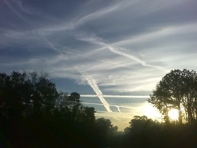
Good answer. I was trying to figure out how to explain exactly that, when I came to your post. The jetways (think jet highways) vary in altitude and direction and cross each other all over the place, usually separated by, I believe, 1000 ft in altitude to avoid collisions. Complicating this is the military, which does not usually have to follow (just avoid) the commercial jetways.
For example, here is the usual route between Los Angeles and San Antonio. Each of these letternumber groups is a separate section of jet airliner "highway".
KLAX TRM J169 BLH KOFFA J50 GBN SSO J50 ELP J2 FST CSI1 KSAT.
KLAX = Los Angeles Lat/Long 33-56-33.1301N / 118-24-29.0680W
Decimal: 33.9425361, -118.4080744
TRM = Palm Springs, CA Lat/Long: 33-37-36.0010N / 116-09-34.7500W
Decimal: 33.6266669, -116.1596528
J169 = Jet route 169
BLH = Blythe, CA Lat/Long: 33-37-08.9860N / 114-43-00.7550W
Decimal: 33.6191628, -114.7168764
KOFFA = intersection in AZ 71 mi. East of Blythe, CA 33-27-48.930N /
113-20-56.100W
Decimal: 33.463333, -113.348889
J50 = Jet route 50
GBN = Gila Bend, AZ Lat/Long: 32-53-15.1680N / 112-43-11.5860W
Decimal: 32.8875467, -112.7198850
SSO = San Simon, AZ Lat/Long 32-16-09.282N/109-15-47.115W
Decimal: 32.2692450, -109.2630875
J50 = Jet route 50
ELP = El Paso, TX Lat/Long 31-48-24.0000N / 106-22-40.1000W
Decimal: 31.8066667, -106.3778056
J2 = Jet route 2
FST = Ft. Stockton, TX Lat/Long 30-54-56.4000N / 102-54-58.1000W
Decimal: 30.9156667, -102.9161389
CSI1. = Center Point 1 Arrival Procedure: From Ft. Stockton, TX to
CSI (Center Point VORTAC ? radio transmitter) Kerrville, TX
Lat/Long 29-55-20.383N / 099-12-52.229W Decimal: 29.9223286 -99.2145081
BENEY (intersection) 29-50-19.760N / 098-59-26.020W Decimal:
29.838611, -98.990556
MEDIN (intersection) 29-48-25.390N / 098-54-00.810W Decimal:
29.806944, -98.900000
REUBE (intersection) 29-45-17.740N / 098-45-35.670W Decimal:
29.754722, -98.759722
AN 368 (Alamo NDB ? radio transmitter) NW of San Antonio 29-36-27.315N /
098-34-10.871W Decimal: 29.6075875 -98.5696864
KSAT = San Antonio, TX Lat/Long 29-32-01.3000N / 098-28-11.2000W
Decimal: 29.5336944, -98.4697778
The "J" prefixes are jet routes, or jet highways. Think of the others as waypoints along those routes. "J50" passes about 40 miles north of Tucson, and I watch the lights move along it at night.
Now, since this route is roughly west to east, if the wind at the assigned altitude is roughly due north or due south, the contrail from each successive airliner in the path will be 5-10 miles behind the one in front of it. If the crosswind is 120 MPH (north or south and perpendicular to the airliner's travel), then the contrail will appear in approximately the same place in the sky (or rather, along the same line in the sky because the jet "highway" doesn't move) but the contrail is now moving north or south at 120 MPH.
Now complicate that with north-south jetways 1-2000 feet higher or lower than the east-west jetways and you achieve a "crosshatch" pattern. Obviously, this would be achieved best if the wind was moving at a 45 degree angle to the crossing jetways.
There, see how I was able to take Mr. Rasmussen's relatively easy answer and give you a headache? There may be such a thing as chemtrails, but if they were truly nefarious and evil they they know they've been "busted", don't you think they would be clever enough to make them invisible? I know Dr. Evil would figure out a way.


")