Earth Chgs Video: How Doggerland Sank Beneath The Waves (500,000-4000 BC) // Prehistoric Europe Documentary

Housecarl

On TB every waking moment
How Doggerland Sank Beneath The Waves (500,000-4000 BC) // Prehistoric Europe Documentary
800,982 views
•Jan 26, 2020
Run time 49:58
View: https://www.youtube.com/watch?v=DECwfQQqRzo


History Time

346K subscribers

Signup for your FREE trial to The Great Courses Plus here: http://ow.ly/IwDC30q7Uwy Watch my latest full length history documentary:- https://youtu.be/c3Hq6UaFQqk — History Time is a one man team. Subscribe to my personal channel here to see me visiting historical sites:- https://www.youtube.com/channel/UCMq-... A selected reading list:- - Neolithic Britain, Keith Ray - Britain BC, Francis Pryor - Britain Begins, Barry Cunliffe - Europe Between The Oceans, Barry Cunliffe - A History of Ancient Britain, Neil Oliver - Mapping Doggerland, Vincent Gaffen - The Remembered Land, Jim Leary - After The Ice, Steven Mithen - Chris Scarre, The Human Past A big thankyou to the following museums:- - The Yorkshire Museum, York - Weston Park Museum, Sheffield - The Natural History Museum, London - The British Museum, London - Derby Museum & Art Gallery, Derby - Hull & East Riding Museum, Hull — Become a patron for as little as a dollar a month & help keep this channel going:- https://www.patreon.com/historytimeUK — History Time is now a podcast. You can find us wherever you get your podcasts from. —Join the History Time community:- Twitter:- https://twitter.com/HistoryTimeUK/ Facebook:- https://www.facebook.com/HistoryTimeO... Instagram:- https://www.instagram.com/historytime... — Music courtesy of:- - Epidemic Sound - Joss Edwards Music:- https://soundcloud.com/jossedwardsmusic * Kevin MacLeod I've compiled a reading list of my favourite history books via the Amazon influencer program. If you do choose to purchase any of these incredible sources of information then Amazon will send me a tiny fraction of the earnings (as long as you do it through the link) (this means more and better content in the future) I'll keep adding to and updating the list as time goes on:- https://www.amazon.com/shop/historytime I try to use copyright free images at all times. However if I have used any of your artwork or maps then please don't hesitate to contact me and I’ll be more than happy to give the appropriate credit.
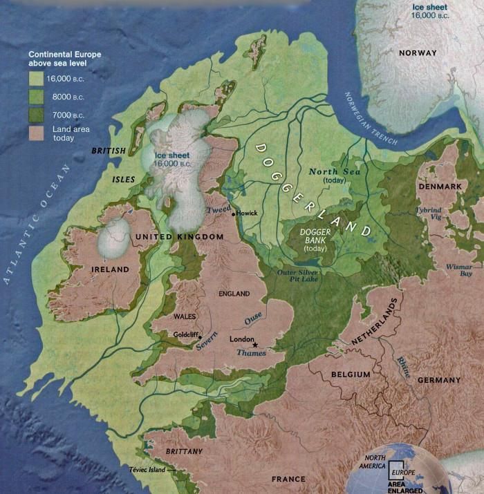
 

jward

passin' thru
eating-popcorn-smiley.gifOh I <3 those glacial melt n change o' the lay o' the land vids ; )- I either get smarter, or caught up on my sleep...2+hrs o' this is almost a whole night's worth.

.. Was just out by the "great inland sea of KS", try as I might, though, I really wasn't getting a feel for it in that time period, n didn't even stumble upon a souvenir from 'the shore'. :shd:

( :: crossin' fingers for oliphants :: )
 

Housecarl

On TB every waking moment
Posted for fair use.....

Study Rewrites History of Ancient Land Bridge Between Britain and Europe
New research suggests that climate change, not a tsunami, doomed the now-submerged territory of Doggerland
The modern map of Britain, a separate island from mainland Europe, with green shading to show a land mass that used to connect the two 16,000, 8,000 and 7,000 years ago
A map of Doggerland, which once connected Britain to mainland Europe (Europe's Lost Frontiers Project)
By Nora McGreevy

smithsonianmag.com
December 2, 2020


As recently as 20,000 years ago—not long in geological terms—Britain was not, in fact, an island. Instead, the terrain that became the British Isles was linked to mainland Europe by Doggerland, a tract of now-submerged territory where early Mesolithic hunter-gatherers lived, settled and traveled.

Doggerland gradually shrank as rising sea levels flooded the area. Then, around 6150 B.C., disaster struck: The Storegga Slide, a submarine landslide off the coast of Norway, triggered a tsunami in the North Sea, flooding the British coastline and likely killing thousands of humans based in coastal settlements, reports Esther Addley for the Guardian.


Historians have long assumed that this tsunami was the deciding factor that finally separated Britain from mainland Europe. But new archaeological research published in the December issue of Antiquity argues that Doggerland may have actually survived as an archipelago of islands for several more centuries.

Co-author Vincent Gaffney, an archaeologist at the University of Bradford, has spent the past 15 years surveying Doggerland’s underwater remains as part of the Europe’s Lost Frontiers project. Using seismic mapping, computer simulations and other techniques, Gaffney and his colleagues have successfully mapped the territory’s marshes, rivers and other geographical features.

For this recent study, the team of British and Estonian archaeologists drew on topography surveys and data obtained by sampling cores of underwater rocks. One sample gathered off of the northern coast of Norfolk contained sedimentary evidence of the long-ago Storegga flood, per the Guardian. Sampling the underwater sediment cores was in and of itself a “major undertaking,” Karen Wicks, an archaeologist at the University of Reading who wasn’t involved in the research, tells Michael Marshall of New Scientist.
Four maps side by side; at 10,000 years ago, Doggerland is expansive and juts into North Sea, by 8200 it is reduced to two small islands and by 7000 the sea has risen to cover it
Archaeologists reconstructed the North Sea coastlines during the pivotal period of about 10,000 to 8,200 years ago. (Antiquity)

According to their revised history, the study’s authors estimate that by about 9,000 years ago, rising sea levels linked to climate change had already reduced Doggerland to a collection of islands. Though the later tsunami wreaked havoc on the existing hunter-gatherer and fishing societies that lived along the British coast, pieces of the landmass—including “Dogger Island” and “Dogger Archipelago,” a tract roughly the size of Wales—likely survived the cataclysmic event, reports Ruth Schuster for Haaretz.


Still, notes New Scientist, while some parts of the land were protected from the brunt of the waves, others were buffeted by waves strong enough to rip trees from their sides.

“If you were standing on the shoreline on that day, 8,200 years ago, there is no doubt it would have been a bad day for you,” Gaffney tells the Guardian. “It was a catastrophe. Many people, possibly thousands of people, must have died.”

The scientists note that this revised history of Doggerland could shift scholars’ understanding of how humans arrived in Britain. As Brooklyn Neustaeter reports for CTV News, the Dogger archipelagos could have served as a staging ground for the first Neolithic farmers, who moved into Britain and began to build permanent settlements on the island. This transition to farming took place some 6,000 years ago, per London’s Natural History Museum.

By about 7,000 years ago, the study suggests, Doggerland would have been long gone, completely submerged by rising sea levels.

“Ultimately, it was climate change that killed Doggerland,” Gaffney tells Haaretz.

Nora McGreevy is a freelance journalist based in Chicago. Her work has appeared in Wired, Washingtonian, the Boston Globe, South Bend Tribune, the New York Times and more. She can be reached through her website, noramcgreevy.com.
 

Housecarl

On TB every waking moment
Meanwhile in the Sahara at about the same time.....

When the Sahara Was Green
RT 8:34
Mar 10, 2020
View: https://www.youtube.com/watch?v=ZQP-7BPvvq0&ab_channel=PBSEons

The climate of the Sahara was completely different thousands of years ago. And we’re not talking about just a few years of extra rain. We’re talking about a climate that was so wet for so long that animals and humans alike made themselves at home in the middle of the Sahara.
 

Publius

TB Fanatic
There was a Britsh group this did a TV show from around the 1990s to sometime in the 2000s called "Time Team" and they did a show on this. Now all their TV Shows can be found on YouTube.com just go to YouTube and use their search engine and enter "Time Team".
 

jward

passin' thru
John Robb
@johnrobb


Doggerland was completely flooded by rising sea levels around 6500–6200 BCE. About the same time as Doggerland began to submerge (16k BC), New England was under 2,000 feet of ice (the Laurentide ICE sheet). It completely melted by 10k BC.
View: https://twitter.com/johnrobb/status/1474037455175180297?s=20


Eclectic Spacewalk
@ESpacewalk

5h

Replying to
@johnrobb


Amazing map!

@BBCInOurTime had an incredibly instructive podcast episode on Doggerland in 2019. Worth a listen. :)
View: https://twitter.com/ESpacewalk/status/1474076674132262920?s=20
 

jward

passin' thru
Doggerland
In Our Time

Melvyn Bragg and guests discuss the growing understanding of the humans, plants and animals once living on land now under the North Sea, submerged in the Stone Age.

LINKS AND FURTHER READING

Vincent Gaffney at the University of Bradford
Carol Cotterill at the British Geological Survey
Rachel Bynoe at the University of Southampton
Europe’s Lost Frontiers project
Submerged Prehistoric Archaeology and Landscapes of the Continental Shelf (SPLASHCOS)
Pioneering populations – Natural History Museum
Building an offshore wind farm - Natural Environment Research Council
Hominin Footprints from Early Pleistocene Deposits at Happisburgh, UK - PLOS One, 2014
From the Field: Rachel Bynoe, Happisburgh – The Leakey Foundation
Of mammoths and other monsters: historic approaches to the submerged Palaeolithic - Antiquity, 2016
Pleistocene terrestrial mammal faunas from the North Sea area - Mededelingen Rijks Geologische Dienst, 1995
A Middle Palaeolithic site in the southern North Sea: Investigating the archaeology and palaeogeography of Area 240 - Journal of Quaternary Science, 2014
Mapping Doggerland: The Mesolithic Landscapes of the Southern North Sea, edited by V. Gaffney, K. Thomson and S. Fitch

READING LIST:
Geoffrey Bailey, Jan Harff and Dimitris Sakellariou, (eds.), Under the Sea: Archaeology and Palaeolandscapes of the Continental Shelf (Springer International, 2017)
Jonathan Benjamin, Clive Bonsall, Catriona Pickard and Anders Fischer (eds.), Submerged Prehistory (Oxbow Books, 2011)
Nicholas C. Flemming, Jan Harff, Delminda Moura, Anthony Burgess and Geoffrey N. Bailey (eds.), Submerged Landscapes of the European Continental Shelf: Quaternary Paleoenvironments (Wiley Blackwell, 2017)
V. Gaffney, S. Fitch, and D. Smith, Europe’s Lost World: The Rediscovery of Doggerland (Council for British Archaeology, 2009)
V. Gaffney, K. Thomson and S. Fitch (eds), Mapping Doggerland: The Mesolithic Landscapes of the Southern North Sea (Archaeopress Archaeology, 2007)
C. Wickham-Jones, Landscape Beneath the Waves: The Archaeological Investigation of Underwater Landscapes (Oxbow Books, 2018)
 

Housecarl

On TB every waking moment
Underwater Cities Mean Ancient Historical Time Lines Are Incorrect
RT 14:32
View: https://www.youtube.com/watch?v=gvugZeuhbBw&ab_channel=Adapt2030

Submerged prehistoric settlements in both the Bland and Mediterranean seas show that these areas were above water 6000 years prior, but sea levels shown at the time by classic academia are off by 1000 years. Additionally erosion patterns at the Kailash Temple complex in India indicate a far older monolithic structure than academia will allow. Out of time artifact where ever we look.


●▬▬▬ ADAPT 2030 MEMBERS ONLY Climate Preparedness Channels ▬▬▬●
Tip Jar via - paypal.me/adapt2030

●▬▬▬ ADAPT 2030 Newsletter ▬▬▬●
...

(ROKU) ADAPT 2030 TV

My Patriot Supply Two Week Food Supply with 92 servings

True Leaf Market Heirloom Seeds
...

ADAPT 2030 Amazon Store: Grand Solar Minimum Preparedness

#underwatercities #kailash #VPN #losthistory #grandsolarminimum #adapt2030 #climaterevolution

●▬▬▬ Story Links ▬▬▬●
Climate Sensitivity Considering Urban and Natural Warming https://notalotofpeopleknowthat.wordp...
Sea Level rise https://ourchangingclimate.wordpress....
Submerged 6,000-year-old prehistoric settlement reveals Black Sea level was 5 meters lower Submerged 6,000-year-old prehistoric settlement reveals Black Sea level was 5 meters lower -- Sott.net...
Nessebar Bulgaria Black Sea Coast Nesebar - Wikipedia
Sozopol, Primorsko Coast Sign in - Google Accounts...
MARITIME ARCHAEOLOGISTS FIND BRONZE AGE SETTLEMENT UNDER BLACK SEA’S SEABED OFF BULGARIA’S COAST http://archaeologyinbulgaria.com/2017...
10 mind-boggling images of the Kailasa Temple 10 mind-boggling images of the Kailasa Temple that prove ancient man had advanced technology - Ancient Code...
Kailasa Temple - Ellora, India https://www.megalithicbuilders.com/as...
Interesting facts about world’s largest monolithic structure-the Kailash Temple in Ellora https://timesofindia.indiatimes.com/t...
Copper-Bronze Crown from the Cave of the Treasure at Nahal Mishmar
View: https://youtu.be/aC0KbjmnoGg

Nahal Mishmar hoard images https://oldeuropeanculture.blogspot.c...
Atlit Yam is an ancient submerged Neolithic village off the coast of Atlit, Israel http://www.israelandyou.com/atlit-yam/

●▬▬▬ PODCAST Mini Ice Age Conversations ▬▬▬●
iTunes: https://itunes.apple.com/us/podcast/a...
Libsyn: http://adapt2030.libsyn.com/
Soundcloud: https://soundcloud.com/adapt-2030 View: https://soundcloud.com/adapt-2030


LIVE BROADCAST Revolution Radio (Studio A)
Thursday Nights 10 PM to Midnight E.S.T.
Freedomslips.com

●▬▬▬ Social ▬▬▬●
MINDS https://minds.com/ADAPT2030
GAB https://gab.ai/adapt2030

STEEMIT https://steemit.com/@adapt2030
MEDIUM https://medium.com/@globalcooling

BRIGHTEON: https://www.brighteon.com/channel/ada...
BITCHUTE: https://www.bitchute.com/channel/dazy...

●▬▬▬ AV Content ▬▬▬●
Created & Produced by David DuByne
 

jed turtle

a brother in the Lord
Atlantis? My first thought.
Nope. Atlantis was right where Plato described it, west of the Pillars of Hercules (Gibraltar),
during the last ice age when the ocean level was low enough to expose the top of the mid-Atlantic Ridge, just before the “Great Flood” (end of the ice age).
 
Top