You are using an out of date browser. It may not display this or other websites correctly.
You should upgrade or use an alternative browser.
You should upgrade or use an alternative browser.
WEATHER Severe Weather the Week of March 26th, 2024 (CLOSED)
- Thread starter packyderms_wife
- Start date
- Status
- Not open for further replies.
packyderms_wife
Neither here nor there.
Current Map | U.S. Drought Monitor.
US Drought Report, it's an interactive map.

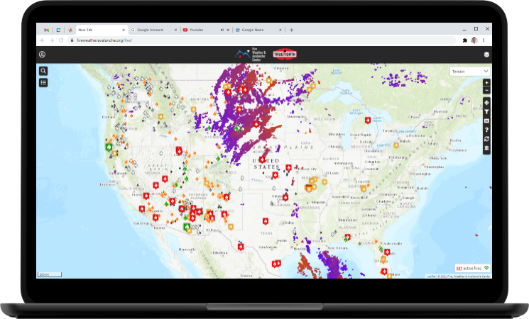
 www.fireweatheravalanche.org
Wildfire map... never thought I'd be posting this one weekly.

 www.star.nesdis.noaa.gov
GOES Sat imagery... you can select different filter views, for dust, smoke, ash, etc
US Drought Report, it's an interactive map.

FWAC Wildfire Map - Current Wildfires, Forest Fires, and Lightning Strikes near you | Fire, Weather & Avalanche Center
Interactive real-time wildfire map for the United States, including California, Oregon, Washington, Idaho, Arizona, and others. See current wildfires and wildfire perimeters near you using the Fire, Weather & Avalanche Center Wildfire Map.


GOES Imagery Viewer - NOAA / NESDIS / STAR
Near real-time publication of GOES-East and GOES-West images from NOAA/NESDIS/STAR
packyderms_wife
Neither here nor there.
It has been pouring rain all morning south of you, Packy. Yesterday's snow is a memory.
Raining here as well, central Iowa just north of Des Moines, still some snow on the ground and lots of thunder. Looks like it's supposed to rain through tomorrow... we really need this rain!
packyderms_wife
Neither here nor there.
RT 9:39 - Max Velocity
In this weather forecast, we are breaking down A BIG STORM that will bring severe weather AND a winter storm to the United States! This storm will bring damaging winds, large hail, and a few tornadoes. Additionally, up to TWO FEET of snow will be possible in the Northern Plains and Upper Midwest! This storm will impact areas like the Northern Plains, Central Plains, Southern Plains, Midwest, and Ohio Valley! Find the latest details of the weather across the United States in our latest weather forecas
packyderms_wife
Neither here nor there.
LIVE STREAM - Max Velocity
BREAKING Tornado Coverage - Tornadoes, Damaging Winds, Large Hail - With Live Storm Chaser
In this live stream, we are breaking down ongoing severe weather in the United States. This severe weather event could bring significant damaging winds, large hail, and tornadoes. This is a live weather channel.packyderms_wife
Neither here nor there.
Severe Weather Statement
National Weather Service Norman OK
414 PM CDT Sun Mar 24 2024
OKC009-242145-
/O.CON.KOUN.TO.W.0005.000000T0000Z-240324T2145Z/
Beckham OK-
414 PM CDT Sun Mar 24 2024
...A TORNADO WARNING REMAINS IN EFFECT UNTIL 445 PM CDT FOR WEST
CENTRAL BECKHAM COUNTY...
At 413 PM CDT, a severe thunderstorm capable of producing a tornado
was located near Erick, moving northeast at 45 mph.
HAZARD...Tornado and quarter size hail.
SOURCE...Radar indicated rotation.
IMPACT...Flying debris will be dangerous to those caught without
shelter. Mobile homes will be damaged or destroyed. Damage
to roofs, windows, and vehicles will occur. Tree damage is
likely.
Locations impacted include...
Erick.
This includes Interstate 40 between mile markers 5 and 10.
PRECAUTIONARY/PREPAREDNESS ACTIONS...
TAKE COVER NOW! Move to a storm shelter, safe room, or an interior
room on the lowest floor of a sturdy building. Avoid windows. If you
are outdoors, in a mobile home, or in a vehicle, move to the closest
substantial shelter and protect yourself from flying debris.
&&
LAT...LON 3514 9995 3521 9996 3528 9984 3518 9981
TIME...MOT...LOC 2113Z 232DEG 40KT 3521 9986
TORNADO...RADAR INDICATED
MAX HAIL SIZE...1.00 IN
$$
..speg.
packyderms_wife
Neither here nor there.
LIVE STEAM - Ryan Hall y'all
LIVE - Tornado Coverage With Storm Chasers On The Ground - Live Weather Channel...
packyderms_wife
Neither here nor there.
This weeks weather thread is up, and it looks like it's gonna get real spicy tomorrow into Tuesday!
 www.timebomb2000.com
WEATHER - Severe Weather for the Week of April 1st, 2024
https://www.weather.gov/
NW Iowa - snow is gone and very light rain showers this a.m. With the snow and rain during March we've moved down a notch on the drought severity chart. For the first time in seven or eight years, my sump pump has been running. We so desperately need every bit of moisture we are getting. Rain in the forecast for tomorrow. I just hope the severe weather stays away!!
- Status
- Not open for further replies.


