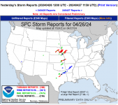
WEATHER Severe Weather the Week of April 22md, 2024 - MODERATE RISK! Saturday 4/27/24

Status
Not open for further replies.

Millwright

Knuckle Dragger
_______________
Red boxes already up, nothing on the radar yet.

We have a bullseye on us, calling for 2"-3" of rain.

I reckon it's gonna blow up fast.

No chasers yet.


activity_loop.gif
 
Last edited:

Red Baron

Paleo-Conservative
_______________
Some rather spicy terminology in today's Day1 outlook.

There will be an update at around 11:30 am CDT.
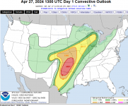
1714230923628.png

Day 1 Convective Outlook
NWS Storm Prediction Center Norman OK
0756 AM CDT Sat Apr 27 2024

Valid 271300Z - 281200Z

...THERE IS A MODERATE RISK OF SEVERE THUNDERSTORMS THROUGH TONIGHT
FOR OK...NORTH TX...SOUTHEAST KS AND EXTREME SOUTHWEST MO...

...SUMMARY...
Severe thunderstorms are likely today and tonight across the
southern and central Plains into the lower to mid Missouri Valley.
The most numerous/intense storms are expected from north Texas into
Oklahoma and southeast Kansas, where strong tornadoes, very large
hail of 2-3 inches in diameter and damaging winds of 60-70 mph are
all possible.

...A regional severe-weather outbreak is expected from north TX
across OK into KS with strong tornadoes, very large hail and
damaging winds all part of a long-duration threat...

...OK/KS/north TX through tonight...
A pronounced midlevel trough over the Four Corners will move
eastward today and then begin to eject northeastward tonight over
the central/southern High Plains. This synoptic pattern will
maintain a lee cyclone in southeast CO and a dryline arcing
southeastward and then southward close to the western OK border.
Farther north, a stalling baroclinic zone will move slowly northward
into northern KS today and central IA by this evening.
A broad, unstable warm sector with boundary-layer dewpoints of 65-70
F will support multiple rounds of severe/tornadic storms through the
period, both along the synoptic boundaries and in parts of the open
warm sector for OK/KS.

The initial severe/tornado threat has already begun near Caprock
from Lubbock to Childress as an embedded jet streak (evident as the
fast-moving cloud streak over west TX) begins to interact with the
northwest edge of the richer low-level moisture. Despite the
unusually early start, there will be the potential for embedded
supercells capable of all hazards as the storms overspread
western/northern OK into southern KS through midday. An outflow
boundary and/or differential heating corridor is likely in the
immediate wake of these morning storms from southern KS into north
central and southwest OK. Additional thunderstorm development is
likely by early-mid afternoon
along this zone and the dryline to the
south into TX, and storms will spread generally northeastward toward
southern/central OK and southeast KS. A moist boundary layer,
MLCAPE of 2500-3500 J/kg and lengthening/enlarging hodographs with
time (as a mass response to the approaching shortwave trough) will
become more favorable for tornadic supercells, including the
potential for long-track EF2-EF3+ tornadoes.
The significant
tornado threat will be greatest if semi-discrete supercells can be
maintained well into the afternoon/evening. Very large hail up to 3
inches in diameter can also be expected with the more intense
supercells.

The storm evolution has the potential to be a bit messy with
multiple training/conjoined supercells, posing a relatively
long-duration and repeat threat to areas within the training storm
corridors across the central third of OK. Damaging winds will
become more probable with storm clustering, and there will likely be
upscale growth into a larger QLCS this evening into tonight as the
primary shortwave trough approaches from the west. The potential
for tornadoes with embedded circulation will continue into the
overnight hours,
along with damaging winds.

...East central CO/far western KS this afternoon/evening...
Near the lee cyclone and a stalled front, thunderstorm development
is expected by early afternoon in a small cluster/arc across east
central CO. Despite boundary-layer dewpoints only in the 40s, cold
midlevel temperatures and steep lapse rates will contribute to
surface-based CAPE up to 1000 J/kg. Relatively large, curved
hodographs will favor supercells capable of producing a few
tornadoes and large hail, as well as damaging gusts once any upscale
growth into a line segment occurs.

...Northern IL/southeast WI/Lower MI this afternoon/evening...
A midlevel trough and associated surface cyclone will move
northeastward today from the upper MS Valley to the upper Great
Lakes. The stronger forcing for ascent has already moved northeast
of the surface warm sector, so storm development in this corridor
will likely be later this afternoon/evening in association with
low-level ascent along the stalling front across WI/lower MI. A
band of storms is expected along the front, and other convection
could eventually spread into northern IL from eastern IA. Forecast
profiles along and south of the front show sufficient hodograph
length/deep-layer shear for organized line segments and some
embedded supercells capable of producing damaging gusts and possibly
a tornado or two. Isolated large hail will also be possible, given
some potential for embedded supercells within the northeast extent
of the 7-8 C/km midlevel lapse rates.

..Thompson/Hart.. 04/27/2024


Meemur

Voice on the Prairie / FJB!
It's overcast in Central Iowa, which is helping to decrease the heat. Round 2 of storms is later today.

Of note: the drought has been so severe that all of the standing water from yesterday's rain has been absorbed. There's just mud left, and that's drying quickly.
 

Red Baron

Paleo-Conservative
_______________
:siren:

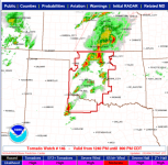
Particularly Dangerous Situation (PDS) Tornado Watch 146

1714243976104.png

URGENT - IMMEDIATE BROADCAST REQUESTED
Tornado Watch Number 146
NWS Storm Prediction Center Norman OK
1240 PM CDT Sat Apr 27 2024

The NWS Storm Prediction Center has issued a

* Tornado Watch for portions of
Western Oklahoma
Northwest Texas

* Effective this Saturday afternoon and evening from 1240 PM
until 800 PM CDT.

...THIS IS A PARTICULARLY DANGEROUS SITUATION...

* Primary threats include...
Several tornadoes and a few intense tornadoes likely
Widespread large hail and scattered very large hail events to 3
inches in diameter likely
Widespread damaging winds and isolated significant gusts to 75
mph likely

SUMMARY...Intense thunderstorms are expected to develop this
afternoon along and east of a dryline over western Oklahoma and
northwest Texas. Supercells are expected, capable of very large
hail and damaging winds. The most intense cells may also produce
strong or potentially long-tracked tornadoes.

The tornado watch area is approximately along and 70 statute miles
east and west of a line from 35 miles east northeast of Alva OK to
45 miles southwest of Wichita Falls TX. For a complete depiction of
the watch see the associated watch outline update (WOUS64 KWNS
WOU6).

PRECAUTIONARY/PREPAREDNESS ACTIONS...

REMEMBER...A Tornado Watch means conditions are favorable for
tornadoes and severe thunderstorms in and close to the watch
area. Persons in these areas should be on the lookout for
threatening weather conditions and listen for later statements
and possible warnings.

&&

OTHER WATCH INFORMATION...CONTINUE...WW 144...WW 145...

AVIATION...Tornadoes and a few severe thunderstorms with hail
surface and aloft to 3 inches. Extreme turbulence and surface wind
gusts to 65 knots. A few cumulonimbi with maximum tops to 500. Mean
storm motion vector 24035.

...Hart


Attachments

  • 1714243806969.png
    1714243806969.png
    220.7 KB · Views: 0

packyderms_wife

Neither here nor there.
Kansas
Tornado Warning
KSC117-149-271930-
/O.NEW.KTOP.TO.W.0016.240427T1855Z-240427T1930Z/

BULLETIN - EAS ACTIVATION REQUESTED
Tornado Warning
National Weather Service Topeka KS
155 PM CDT Sat Apr 27 2024

The National Weather Service in Topeka has issued a

* Tornado Warning for...
North central Pottawatomie County in northeastern Kansas...
Southeastern Marshall County in northeastern Kansas...

* Until 230 PM CDT.

* At 155 PM CDT, a severe thunderstorm capable of producing a tornado
was located 4 miles west of Blaine, moving northeast at 30 mph.

HAZARD...Tornado and ping pong ball size hail.

SOURCE...Radar indicated rotation.

IMPACT...Flying debris will be dangerous to those caught without
shelter. Mobile homes will be damaged or destroyed.
Damage to roofs, windows, and vehicles will occur. Tree
damage is likely.

* This dangerous storm will be near...
Blaine and Wheaton around 200 PM CDT.
Lillis around 205 PM CDT.

PRECAUTIONARY/PREPAREDNESS ACTIONS...

TAKE COVER NOW! Move to a basement or an interior room on the lowest
floor of a sturdy building. Avoid windows. If you are outdoors, in a
mobile home, or in a vehicle, move to the closest substantial shelter
and protect yourself from flying debris.

&&

LAT...LON 3957 9624 3956 9622 3948 9623 3943 9651
3953 9662 3973 9624
TIME...MOT...LOC 1855Z 242DEG 26KT 3949 9648

TORNADO...RADAR INDICATED
MAX HAIL SIZE...1.50 IN

$$
 

packyderms_wife

Neither here nor there.
Kansas

Severe Weather Statement
National Weather Service Topeka KS
159 PM CDT Sat Apr 27 2024

KSC013-271915-
/O.CON.KTOP.TO.W.0015.000000T0000Z-240427T1915Z/
Brown-
159 PM CDT Sat Apr 27 2024

...A TORNADO WARNING REMAINS IN EFFECT UNTIL 215 PM CDT FOR
NORTHEASTERN BROWN COUNTY...

At 159 PM CDT, a severe thunderstorm capable of producing a tornado
was located 4 miles northwest of Robinson, moving northeast at 35
mph.

HAZARD...Tornado and quarter size hail.

SOURCE...Radar indicated rotation.

IMPACT...Flying debris will be dangerous to those caught without
shelter. Mobile homes will be damaged or destroyed. Damage
to roofs, windows, and vehicles will occur. Tree damage is
likely.

This tornadic thunderstorm will remain over mainly rural areas of
northeastern Brown County, which includes Iowa Reservation of Kansas
and Nebraska.

PRECAUTIONARY/PREPAREDNESS ACTIONS...

TAKE COVER NOW! Move to a basement or an interior room on the lowest
floor of a sturdy building. Avoid windows. If you are outdoors, in a
mobile home, or in a vehicle, move to the closest substantial shelter
and protect yourself from flying debris.

&&

LAT...LON 3988 9534 3983 9545 3988 9553 4000 9544
4000 9534
TIME...MOT...LOC 1859Z 223DEG 32KT 3988 9545

TORNADO...RADAR INDICATED
MAX HAIL SIZE...1.00 IN

$$

Reese
 

Red Baron

Paleo-Conservative
_______________
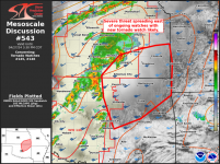
1714244536342.png

Mesoscale Discussion 0543
NWS Storm Prediction Center Norman OK
0154 PM CDT Sat Apr 27 2024

Areas affected...Northeast OK and southeast KS

Concerning...Tornado Watch 145...146...

Valid 271854Z - 272030Z

The severe weather threat for Tornado Watch 145, 146 continues.

SUMMARY...As severe storms in north-central Oklahoma and
south-central Kansas spread east late this afternoon, an additional
tornado watch will likely be needed.

DISCUSSION...The airmass ahead of severe storms in south-central KS
and north-central OK continues to destabilize as surface temps have
warmed in the upper 70s to low 80s across most of eastern OK into
far southeast KS. While low-level shear within this part of the
warm-moist sector is relatively modest per INX VWP data, it will
strengthen based on upstream TLX data. A mix of discrete and
semi-discrete supercells occasionally embedded within clusters
should spread east-northeast through late afternoon
. As this occurs,
all severe hazards will be possible, some of which may be
significant.

..Grams.. 04/27/2024

...Please see www.spc.noaa.gov for graphic product...
 

packyderms_wife

Neither here nor there.
Missouri

Tornado Warning
KSC043-MOC087-271945-
/O.NEW.KEAX.TO.W.0006.240427T1906Z-240427T1945Z/

BULLETIN - EAS ACTIVATION REQUESTED
Tornado Warning
National Weather Service Kansas City/Pleasant Hill MO
206 PM CDT Sat Apr 27 2024

The National Weather Service in Pleasant Hill has issued a

* Tornado Warning for...
Northwestern Doniphan County in northeastern Kansas...
Central Holt County in northwestern Missouri...

* Until 245 PM CDT.

* At 206 PM CDT, a severe thunderstorm capable of producing a tornado
was located near Robinson, or 7 miles northeast of Hiawatha, moving
northeast at 30 mph.

HAZARD...Tornado and quarter size hail.

SOURCE...Radar indicated rotation.

IMPACT...Flying debris will be dangerous to those caught without
shelter. Mobile homes will be damaged or destroyed.
Damage to roofs, windows, and vehicles will occur. Tree
damage is likely.

* Locations impacted include...
Mound City, Oregon, Forest City, White Cloud, Big Lake, Fortescue,
Bigelow, Iowa Point, and Iowa Reservation of Kansas and Nebraska.

This includes Interstate 29 between mile markers 69 and 87.

PRECAUTIONARY/PREPAREDNESS ACTIONS...

TAKE COVER NOW! Move to a basement or an interior room on the lowest
floor of a sturdy building. Avoid windows. If you are outdoors, in a
mobile home, or in a vehicle, move to the closest substantial shelter
and protect yourself from flying debris.

&&

LAT...LON 4018 9526 3999 9501 3985 9534 4000 9534
4000 9531 4003 9535 4003 9540 4004 9542
TIME...MOT...LOC 1906Z 224DEG 26KT 3991 9541

TORNADO...RADAR INDICATED
MAX HAIL SIZE...1.00 IN

$$

BMW
 

packyderms_wife

Neither here nor there.
Oklahoma
Severe Weather Statement
National Weather Service Norman OK
219 PM CDT Sat Apr 27 2024

TXC155-275-271945-
/O.CON.KOUN.TO.W.0019.000000T0000Z-240427T1945Z/
Foard TX-Knox TX-
219 PM CDT Sat Apr 27 2024

...A TORNADO WARNING REMAINS IN EFFECT UNTIL 245 PM CDT FOR
SOUTHEASTERN FOARD AND NORTHEASTERN KNOX COUNTIES...

At 219 PM CDT, a severe thunderstorm capable of producing a tornado
was located near Gilliland, moving northeast at 25 mph.

HAZARD...Tornado and tennis ball size hail.

SOURCE...Radar indicated rotation.

IMPACT...Flying debris will be dangerous to those caught without
shelter. Mobile homes will be damaged or destroyed. Damage
to roofs, windows, and vehicles will occur. Tree damage is
likely.

Locations impacted include...
Gilliland.

PRECAUTIONARY/PREPAREDNESS ACTIONS...

TAKE COVER NOW! Move to a storm shelter, safe room, or an interior
room on the lowest floor of a sturdy building. Avoid windows. If you
are outdoors, in a mobile home, or in a vehicle, move to the closest
substantial shelter and protect yourself from flying debris.

&&

LAT...LON 3362 9980 3371 9986 3388 9954 3370 9954
TIME...MOT...LOC 1919Z 231DEG 22KT 3371 9975

TORNADO...RADAR INDICATED
MAX HAIL SIZE...2.50 IN

$$

MDU
 

packyderms_wife

Neither here nor there.
Kansas

Tornado Warning
KSC085-131-149-272000-
/O.NEW.KTOP.TO.W.0017.240427T1914Z-240427T2000Z/

BULLETIN - EAS ACTIVATION REQUESTED
Tornado Warning
National Weather Service Topeka KS
214 PM CDT Sat Apr 27 2024

The National Weather Service in Topeka has issued a

* Tornado Warning for...
Northeastern Pottawatomie County in northeastern Kansas...
Southern Nemaha County in northeastern Kansas...
Northwestern Jackson County in northeastern Kansas...

* Until 300 PM CDT.

* At 213 PM CDT, a severe thunderstorm capable of producing a tornado
was located over Wheaton, moving east at 35 mph.

HAZARD...Tornado and ping pong ball size hail.

SOURCE...Radar indicated rotation.

IMPACT...Flying debris will be dangerous to those caught without
shelter. Mobile homes will be damaged or destroyed.
Damage to roofs, windows, and vehicles will occur. Tree
damage is likely.

* This dangerous storm will be near...
Onaga and Havensville around 220 PM CDT.
Corning around 230 PM CDT.
Soldier around 235 PM CDT.
Goff around 240 PM CDT.

PRECAUTIONARY/PREPAREDNESS ACTIONS...

TAKE COVER NOW! Move to a basement or an interior room on the lowest
floor of a sturdy building. Avoid windows. If you are outdoors, in a
mobile home, or in a vehicle, move to the closest substantial shelter
and protect yourself from flying debris.

&&

LAT...LON 3951 9578 3944 9626 3957 9625 3957 9624
3966 9624 3984 9579
TIME...MOT...LOC 1913Z 248DEG 28KT 3952 9629

TORNADO...RADAR INDICATED
MAX HAIL SIZE...1.50 IN

$$
 

packyderms_wife

Neither here nor there.
Nebraska

Tornado Warning
NEC147-271945-
/O.NEW.KOAX.TO.W.0051.240427T1917Z-240427T1945Z/

BULLETIN - EAS ACTIVATION REQUESTED
Tornado Warning
National Weather Service Omaha/Valley Nebraska
217 PM CDT Sat Apr 27 2024

The National Weather Service in Omaha has issued a

* Tornado Warning for...
Northeastern Richardson County in southeastern Nebraska...

* Until 245 PM CDT.

* At 217 PM CDT, a severe thunderstorm capable of producing a tornado
was located 5 miles east of Verdon, or 6 miles north of Falls City,
moving northeast at 25 mph.

HAZARD...Tornado and quarter size hail.

SOURCE...Radar indicated rotation.

IMPACT...Flying debris will be dangerous to those caught without
shelter. Mobile homes will be damaged or destroyed.
Damage to roofs, windows, and vehicles will occur. Tree
damage is likely.

* This tornadic thunderstorm will remain over mainly rural areas of
northeastern Richardson County, including the following
locations... Indian Cave State Park and Barada.

PRECAUTIONARY/PREPAREDNESS ACTIONS...

TAKE COVER NOW! Move to a basement or an interior room on the lowest
floor of a sturdy building. Avoid windows. If you are outdoors, in a
mobile home, or in a vehicle, move to the closest substantial shelter
and protect yourself from flying debris.

&&

LAT...LON 4016 9572 4026 9562 4026 9555 4025 9552
4025 9549 4023 9547 4020 9548 4017 9546
4009 9560
TIME...MOT...LOC 1917Z 226DEG 21KT 4016 9561

TORNADO...RADAR INDICATED
MAX HAIL SIZE...1.00 IN

$$

Nicolaisen
 

packyderms_wife

Neither here nor there.
Missouri

Tornado Warning
MOC003-087-147-272015-
/O.NEW.KEAX.TO.W.0007.240427T1937Z-240427T2015Z/

BULLETIN - EAS ACTIVATION REQUESTED
Tornado Warning
National Weather Service Kansas City/Pleasant Hill MO
237 PM CDT Sat Apr 27 2024

The National Weather Service in Pleasant Hill has issued a

* Tornado Warning for...
Northeastern Holt County in northwestern Missouri...
Southwestern Nodaway County in northwestern Missouri...
Northwestern Andrew County in northwestern Missouri...

* Until 315 PM CDT.

* At 237 PM CDT, a severe thunderstorm capable of producing a tornado
was located near Mound City, moving northeast at 30 mph.

HAZARD...Tornado and quarter size hail.

SOURCE...Radar indicated rotation.

IMPACT...Flying debris will be dangerous to those caught without
shelter. Mobile homes will be damaged or destroyed.
Damage to roofs, windows, and vehicles will occur. Tree
damage is likely.

* Locations impacted include...
Mound City, Maitland, Skidmore, Barnard, and Graham.

This includes Interstate 29 between mile markers 75 and 87.

PRECAUTIONARY/PREPAREDNESS ACTIONS...

TAKE COVER NOW! Move to a basement or an interior room on the lowest
floor of a sturdy building. Avoid windows. If you are outdoors, in a
mobile home, or in a vehicle, move to the closest substantial shelter
and protect yourself from flying debris.

&&

LAT...LON 4002 9516 4015 9529 4036 9496 4016 9475
TIME...MOT...LOC 1937Z 228DEG 28KT 4010 9518

TORNADO...RADAR INDICATED
MAX HAIL SIZE...1.00 IN

$$

BMW
 

packyderms_wife

Neither here nor there.
Tornado Warning
KSC013-131-272100-
/O.NEW.KTOP.TO.W.0018.240427T1955Z-240427T2100Z/

BULLETIN - EAS ACTIVATION REQUESTED
Tornado Warning
National Weather Service Topeka KS
255 PM CDT Sat Apr 27 2024

The National Weather Service in Topeka has issued a

* Tornado Warning for...
East central Nemaha County in northeastern Kansas...
Brown County in northeastern Kansas...

* Until 400 PM CDT.

* At 254 PM CDT, a confirmed tornado was located over Woodlawn,
moving northeast at 35 mph.

HAZARD...Damaging tornado and golf ball size hail.

SOURCE...Emergency management confirmed tornado.

IMPACT...Flying debris will be dangerous to those caught without
shelter. Mobile homes will be damaged or destroyed.
Damage to roofs, windows, and vehicles will occur. Tree
damage is likely.

* The tornado will be near...
Sabetha, Fairview, and Powhattan around 300 PM CDT.
Hiawatha, Morrill, and Hamlin around 310 PM CDT.
Reserve around 320 PM CDT.

Other locations impacted by this tornadic thunderstorm include Iowa
Reservation of Kansas and Nebraska and Sac and Fox Nation
Reservation.

PRECAUTIONARY/PREPAREDNESS ACTIONS...

To repeat, a tornado is on the ground. TAKE COVER NOW! Move to a
basement or an interior room on the lowest floor of a sturdy
building. Avoid windows. If you are outdoors, in a mobile home, or in
a vehicle, move to the closest substantial shelter and protect
yourself from flying debris.

&&

LAT...LON 3977 9534 3967 9585 3985 9592 4000 9564
4000 9534
TIME...MOT...LOC 1954Z 239DEG 29KT 3976 9585

TORNADO...OBSERVED
MAX HAIL SIZE...1.75 IN

$$
 

Red Baron

Paleo-Conservative
_______________
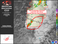
Current area of the greatest concern,

1714252062208.png

Mesoscale Discussion 0544
NWS Storm Prediction Center Norman OK
0319 PM CDT Sat Apr 27 2024

Areas affected...Western north TX and southwest OK

Concerning...Tornado Watch 146...

Valid 272019Z - 272145Z

The severe weather threat for Tornado Watch 146 continues.

SUMMARY...Pair of potentially long-lived supercells within the
southern portion of WW 146 may evolve with an intense tornado and
very large hail threat.

DISCUSSION...A potentially long-lived, slow-moving discrete
supercell is centered over Knox County, TX. This supercell appears
to be anchored along the far southern portion of the broader
convective plume that extends north across OK/KS. With full
insolation in the warm-moist sector inflow to its southeast, its
plausible that a long-lived supercell will persist for the next 2-3
hours.
Amid MLCAPE of 3000 J/kg and mid 60s surface dew points to
its southeast, a cyclic tornadic supercell could evolve beyond the
very large hail threat with up to baseballs reported thus far.
The
supercell to its northeast in Wilbarger County, TX will also have
potential to further intensify as it spreads towards and northwest
of the Wichita Falls vicinity, given 0-1 km SRH of 100-200 m2/s2 per
FDR VWP data.

..Grams.. 04/27/2024
 
Status
Not open for further replies.
Top