Solar Grand Solar Minimum part deux

TxGal

Day by day
Adapt 2030 has a new podcast out this morning. I'm posting it because it's discussing massive crop yield declines:

2022 Prices Will Skyrocket Not Economic Activity - YouTube

2022 Prices Will Skyrocket Not Economic Activity
10,095 views
Dec 10, 2021

View: https://youtu.be/Zb1oUUeecL8
Run time is 32:07

Synopsis provided:

Bob Kudla from Tradelikeagenius.com and David DuByne of ADAPT 2030 discuss how fertilizer shortages are destabilizing countries with rising food prices coupled with natural gas & electricity shortfalls leading to massive crop yield declines. 2022 will be remembered as food insecurity and rationing with a market crash rivaling 1928-1929.
 

TxGal

Day by day
Martinhouse, are you doing okay up there? It looked like those storms might be hitting in your general area. Nasty stuff.

We got the very tail end of that line sometime after midnight. We had about half an hour to an hour of lightning, thunder, gusty winds, I think some light hail and of course, rain. But, it could have been so much worse.

Temps are falling now, still very windy. We're forecasted to drop to 31 overnight. Lovely. Fortunately, it's just supposed to be one night of below freezing. Next week we warm back up.

I really hate winter!
 

Martinhouse

Deceased
TxGal, I think that whole system had two tails! We got the shorter, more northern tail about ten o'clock or so and it was very short-lived and not violent at all. As I said on the thread about reporting in on our storms, we got really lucky here in my area.

It's nasty chilly and windy here right now. I got up at five and left at five-thirty to go small town shopping...grocery and Dollar General. It was SO COLD out! I was home by 8:10 and I still haven't made myself go back out and unload the groceries and stuff. I meant to do it right away, but just feeding the cats turned me right back into an icicle!

I HATE WINTER!!!!!

And this time, the change in weather made all the ouchy places in and on my body hurt about nine or ten times as much as they normally do. Ugh! Not fun to be awakened before the alarm goes off, just from the throb of one's heartbeat all over one's body!

I didn't move far enough south! Wonder what it's like in Panama? (: (: (:
 
Last edited:

TxGal

Day by day
TxGal, I think that whole system had two tails! We got the shorter, more northern tail about ten o'clock or so and it was bery short-lived and not violent at all. As I said on the thread about reporting in on our storms, we got really lucky here in my area.

It's nasty chilly and windy here right now. I got up at five and left at five-thirty to go small town shopping...grocery and Dollar General. It was SO COLD out! I was home by 8:10 and I still haven't made myself go back out and unload the groceries and stuff. I meant to do it right away, but just feeding the cats turned me right back into an icicle!

I HATE WINTER!!!!!

And this time, the change in weather made all the ouchy places in and on my body hurt about nine or ten times as much as they normally do. Ugh! Not fun to be awakened before the alarm goes off, just from the throb of one's heartbeat all over one's body!

I didn't move far enugh south! Wonder what it's like in Panama? (: (: (:
Glad you're okay! I think we both got lucky, you were much closer to the nasty end of it, I think. There were some severe storms south of us, but nothing like what happened in the other states.

Understand the pains of the cold! I went out with two pairs of sweat pants, a tank top under a long-sleeved knit top, a sweat shirt over that, a hoodie sweatshirt over that, and a hoodie jacket. I hate the cold! Our skies are starting to clear out now, so that will mean a cold night. Hate it!

I think it gets cold in Panama, too :-)
 

TxGal

Day by day
Adapt 2030 has a new podcast out:

Some Governments are Preparing for Grid Down (Jeff Nyquist 1/3) - YouTube

Some Governments are Preparing for Grid Down (Jeff Nyquist 1/3)
12,501 views
Dec 11, 2021

View: https://youtu.be/juJAs01Vyic
Run time is 32:09

Synopsis provided:

Jeffrey Nyquist and I sat down to discuss Earth’s electromagnetic field, food supply issues, farming, and theories regarding catastrophic earth changes. One of the big questions is whether the Chinese and Russians have advanced knowledge of these climate changes. If so, are there strategic ramifications?
 

TxGal

Day by day
Adapt 2030 has posted the 2nd podcast in the series he started yesterday:

Projections for Our Civilizations Downfall (Jeff Nyquist 2/3) - YouTube

Projections for Our Civilizations Downfall (Jeff Nyquist 2/3)
7,174 views
Dec 11, 2021

View: https://youtu.be/5CXAEKpfuS0
Run time is 28:41

Synopsis provided:

Jeffrey Nyquist and I sat down to discuss Earth’s electromagnetic field, food supply issues, farming, and theories regarding catastrophic earth changes. One of the big questions is whether the Chinese and Russians have advanced knowledge of these climate changes. If so, are there strategic ramifications?
 

TxGal

Day by day
Hey Martinhouse, what was your low this morning?

We hit 29 around 0600, and had a very heavy frost. Steam coming off the pond is kinda pretty, though.

Really hate winter! Hard boiled eggs are done, baked potatoes are done and the kitchen is nice and warm. We finally reached 40 a few minutes ago. Thankfully, we're supposed to be 60 today and sunny, and a low overnight of just 41.
 

RememberGoliad

Veteran Member
Bottomed out at 28 here, water didn't freeze up though. Dodged THAT bullet. (Never did get wellhead and pressure switch wrapped, just put out clamp lights and incandescent Christmas lights.)

Up to 44 now, probably 62 for high, they say.

The internet "official" forecasts were calling for a low of 32. I've been noticing our temps are below the "official" forecast but seems our local AM station tweaks that a bit and pretty much nails it within a degree or two. They were warning of upper 20's all day yesterday.
 

Digger

Veteran Member
I think it might be more than 100 miles. We are in north west central part of our state. But I am bad with distance. I think it takes longer than 2 hours to get to the Texas state line. But I haven't been that direction in years and it wasn't as the crow flys, but as the roads go. :shr:
 

Martinhouse

Deceased
It was 26 here when I got up at 8 AM and right now it is 41 right behind my house. Predicted low for my immediate area was 28 and though I used to always be a little higher than the predictions, (probably because I've let my place grow almost totally over in trees and brush) Recently, I've been running about two to four degrees lower than has been forecast for the overnight lows.

Looks like our warmer than usual temps are about over. Now I have to endure two or three months of dreading to get out of my nice warm bed in the mornings because I do not have central heat any more and there's no way I will leave a portable heater running while I sleep.

I just hate winter so much. I'll probably be spending most of my time for the next many weeks just knitting or, on sunny days, scratching around in my greenhouse, which I can just step into through a door I made next to my kitchen/living room door.
 

northern watch

TB Fanatic
Heavy snowfall wreaks havoc in Serbia and much of Balkans
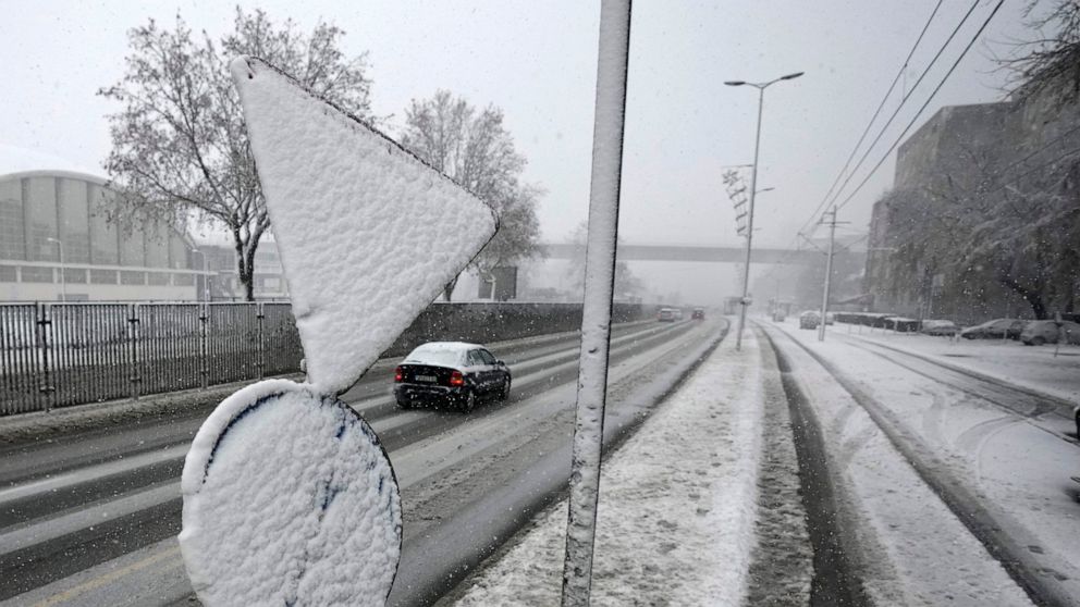
Heavy snowfall has covered Serbian capital Belgrade and much of the Balkans
By The Associated Press
12 December 2021, 09:34

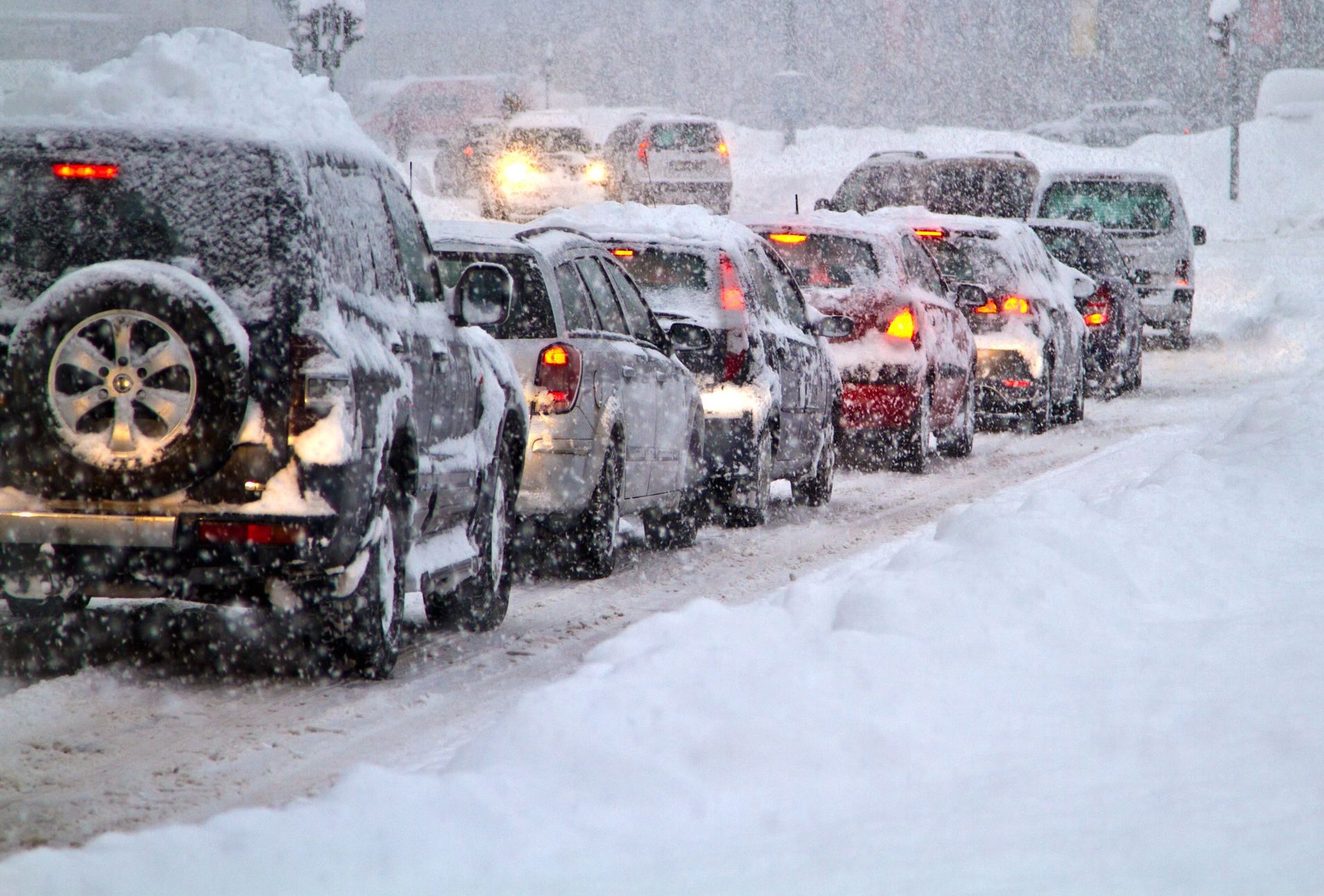
Cars on the street during snow storm in Belgrade, Serbia, Sunday, Dec. 12, 2021. Meteorologists predict heavy snowfall and sub zero temperatures in the Western Balkans throughout the week. (AP Photo/Darko Vojinovic)

Image Icon
The Associated Press
Cars on the street during snow storm in Belgrade, Serbia, Sunday, Dec. 12, 2021. Meteorologists predict heavy snowfall and sub zero temperatures in the Western Balkans throughout the week. (AP Photo/Darko Vojinovic)

BELGRADE, Serbia -- Heavy snowfall covered Belgrade and much of the Balkans on Sunday, hampering traffic, canceling flights at the Serbian capital’s main airport and disrupting public transportation.

Many areas across the country reported power cuts and damages to buildings due to falling trees. The icy conditions saw trucks skidding across the roads and getting stuck while ploughs were being used to pull them out.

Much of western Serbia was without electricity as authorities warned against unnecessary travel and appealed to people in Serbia to conserve power.

In the capital, several trees fell under the weight of the heavy snow, damaging cars and buildings. Some people had to be rescued after being trapped in their damaged vehicles.

Several flights from and to Belgrade’s main airport were canceled because of the weather conditions and a brief power cut to the main terminal, Belgrade media reported. A highway leading to the airport was closed for several hours because of a traffic jam caused by the snowfall.

Passengers on a local train to Belgrade were stuck in snow for seven hours before they were provided bus transportation to the capital

Emergency services have been assisting authorities in the cleanup operation throughout Sunday, while another alert for more snow and ice has been issued.

In Bulgaria, heavy rains and major floods have been ravaging southern parts of the country over the weekend, forcing authorities there to declare a state of emergency.

The worst-hit areas were in the Smolyan region, near the border with Greece, where rivers burst their banks to cause the overflowing of roads and the flooding of homes. Several trucks were trapped in a landslide on an intercity road.

Strong winds disrupted power supply in dozens of villages, authorities said.

Further south in Albania, authorities mobilized police, army and emergency forces to cope with floods following three days of continuous rainfall and snow.

The Vjosa River in the south flooded many areas. An older couple who had stayed overnight on the rooftop of their house in southwest Albania was rescued by police in the morning.

Many roads were temporarily blocked by landslides in the south. Elsewhere in the northeast and southeast of the country, heavy snow has hampered or temporarily blocked traffic.

Heavy snowfall wreaks havoc in Serbia and much of Balkans - ABC News (go.com)
 

TxGal

Day by day
Adapt 2030 has posted parts 3 and 4 of the series:

Nobody Will Escape This (Jeff Nyquist 3/4) - YouTube

Nobody Will Escape This (Jeff Nyquist 3/4)
10,829 views
Dec 12, 2021

View: https://youtu.be/qupaemXvG6M
Run time is 18:50

Synopsis provided:

Jeffrey Nyquist and I sat down to discuss Earth’s electromagnetic field, food supply issues, farming, and theories regarding catastrophic earth changes. One of the big questions is whether the Chinese and Russians have advanced knowledge of these climate changes. If so, are there strategic ramifications?

------------------------------------------------------------------------

A Global Shackleton Event (Jeff Nyquist 4/4) - YouTube

A Global Shackleton Event (Jeff Nyquist 4/4)
3,931 views
Dec 13, 2021

View: https://youtu.be/B13F4NLzWdU
Run time is 20:07

Synopsis provided:

Jeffrey Nyquist and I sat down to discuss Earth’s electromagnetic field, food supply issues, farming, and theories regarding catastrophic earth changes. One of the big questions is whether the Chinese and Russians have advanced knowledge of these climate changes. If so, are there strategic ramifications?
 

TxGal

Day by day
From The Oppenheimer Ranch Project:

Deadly US Tornado Outbreak - Record Snow Forecast - La Palma Update - Solar Outburst Warning - YouTube

Deadly US Tornado Outbreak - Record Snow Forecast - La Palma Update - Solar Outburst Warning
5,525 views
Premiered 17 hours ago

View: https://youtu.be/LuDFyywBVos
Run time is 16:53

Synopsis provided:

Tornado Death Toll Rises as States Assess Damage https://nyti.ms/3pMAO21
Rescuers hunt for survivors after deadly tornadoes pummel several states https://nbcnews.to/3DRWgHI
Tornadoes in St. Louis area leave at least 7 people dead https://bit.ly/3ETz6SI
Six people killed in Illinois Amazon warehouse collapse https://cnn.it/33pqO7l
The 2011 Super Outbreak was the largest, costliest, and one of the deadliest tornado outbreaks ever recorded https://bit.ly/3GFRNcS
Strong winds blow through Michigan, nearly 200,000 without power Saturday https://bit.ly/3ITwKps
Power Outage US https://poweroutage.us/
Hawaii storm breaks records and leaves behind trail of damage https://bit.ly/30ig35q
Powerful storm heading to Sierra Nevada, NorCal bringing heavy rains, up to 10 feet of snow https://bit.ly/3oLI2np
Major winter storm could dump up to 100 inches of snow in Tahoe https://bit.ly/3lUmbsc
SNOWFALL ANALYSIS FROM THE LAST 24 HOURS https://www.weather.gov/crh/snowfall
Unsettled Across the Western U.S.; Critical Fire Weather Conditions for the Southern High Plains https://www.weather.gov/
GFS Model Total Snowfall US https://bit.ly/3yhg6uZ
La Palma volcano update: Eruption continues, but at gradually decreasing intensity https://bit.ly/3lX7HYy
latest quakes near La Palma volcano: past 24 hours https://bit.ly/3hLpMXk http://www.ign.es/web/resources/volca...
Davidof volcano (Aleutian Islands): seismic swarm, Volcanic Alert Level raised to Yellow https://bit.ly/3dLQ8q4
Large Eruption From Nearby Star Is a Warning for Earth https://bit.ly/3ILghnd
EK Draconis Facts https://www.universeguide.com/star/71...
Astronomers Have Discovered Why The Solar System Might Be Shaped Like a Croissant https://bit.ly/3mjK9gX
Ancient DNA Discovery Reveals Woolly Mammoths, Wild Horses Survived Thousands of Years Longer Than Believed https://bit.ly/3yjI4Gh
Fate of Sinking Tectonic Plates Has Long Puzzled Scientists – Now They’ve Found an Answer https://bit.ly/3dMcsQ8
5 Tips on How To Escape An Erupting Volcano
https://bit.ly/3yk3i74
 

TxGal

Day by day
FEMA administrator on extreme weather: 'This is going to be our new normal' -- Earth Changes -- Sott.net

FEMA administrator on extreme weather: 'This is going to be our new normal'

Mychael Schnell
The Hill
Sun, 12 Dec 2021 18:40 UTC

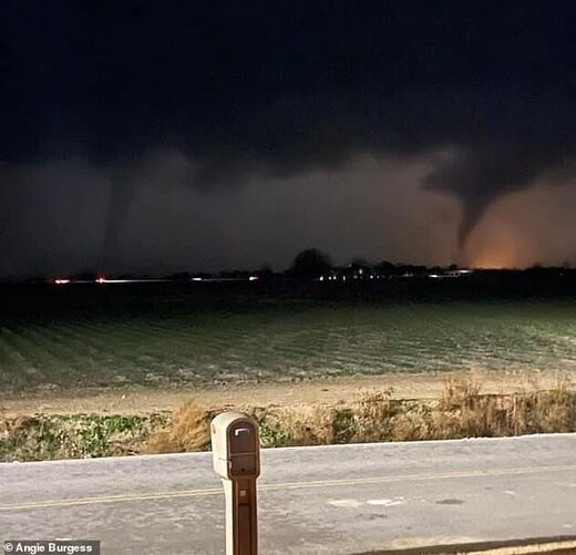
tornado

Federal Emergency Management Agency (FEMA) Administrator Deanne Criswell on Sunday said extreme weather events like the storms and tornadoes that swept through a number of states this weekend "is going to be our new normal," pointing to the effects of climate change.

"This is going to be our new normal and the effects that we're seeing from climate change are the crisis of our generation," Criswell told co-host Jake Tapper on CNN's "State of the Union."

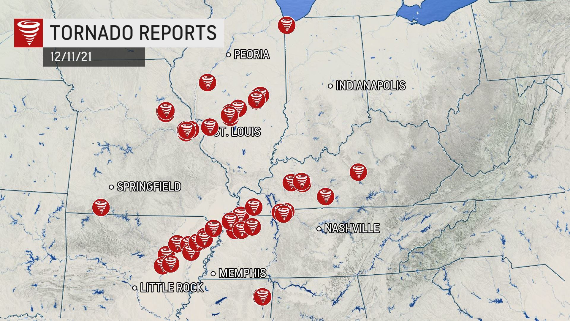
Severe storms and tornadoes tore through states in the South and Midwest late Friday into Saturday, leaving devastating damage, tens of thousands of homes without power and nearly 100 people dead.

Kentucky Gov. Andy Beshear (D) said more than 80 individuals have died in his state as a result of the storm, while warning that the number is expected to grow larger than 100.

Asked how unusual it is to see such a powerful storm this late in the year, Criswell told Tapper "I think it's incredibly unusual," pointing to the magnitude and timing of the cyclone.

"We do see tornadoes in December, that part is not unusual, but at this magnitude I don't think we've ever seen one this late in the year. But it's also historic. Even this, the severity and the amount of time this tornado, or these tornadoes, spent on the ground is unprecedented," Criswell said.

The FEMA administrator said her agency is working with communities in making efforts to "help reduce the impacts that we're seeing from these severe weather events and help to develop system-wide projects that can help protect communities."

Comment: See also: Record-breaking tornado outbreak hits US: At least 3-dozen tornadoes form, including monster that dragged 4 states - At least 100 killed
 

Martinhouse

Deceased
When I read that comment "This is going to be our new normal" I actually felt the hair on the back of my neck stir...all those little muscles tightening. I don't think that's ever happened to me like that before.

I live high enough on a slight slope that it's unlikely that I'd ever see a flood at my doorstep, but I'm as susceptible to hail, high winds and tornadoes as anyone else. The only thing I've ever been able to afford to do about any damage from such things is to buy enough tarps and a way to tie them down that I could keep a damaged roof covered until I could find someone to repair it for me. It would likely be a real patchwork of used lumber and odds and ends of roofing, but with materials becoming less and less available or affordable, I expect lots of people would be doing patchwork repairs if they're even lucky enough to have anything left to be repaired.
 

flame

Senior Member
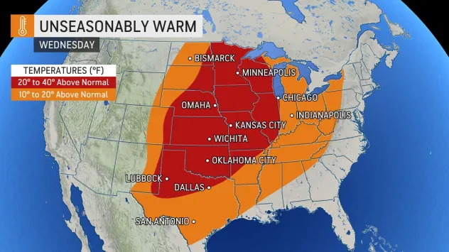
looks like Wednesday will be amazingly warm here..plus a high wind warning has already been issued, with winds gusting up to 65 mph..
Looks like I picked a hellofa day to finish christmas shopping..lol

Southwest Iowa..
 

packyderms_wife

Neither here nor there.
looks like Wednesday will be amazingly warm here..plus a high wind warning has already been issued, with winds gusting up to 65 mph..
Looks like I picked a hellofa day to finish christmas shopping..lol

Southwest Iowa..

I've been reading from various weather sources online, they're talking 70 to 85 mph gusts for central Iowa.
 

TxGal

Day by day
The Oppenheimer Ranch Project has a new podcast out:

7.6 Downgraded In Indonesia - Record Snow Falling West US - Grimsvötn Jökulhlaup Watch - Record Cold - YouTube

7.6 Downgraded In Indonesia - Record Snow Falling West US - Grimsvötn Jökulhlaup Watch - Record Cold
3,478 views
Premiered 8 hours ago

View: https://youtu.be/Dq3q0CmnpF8
Run time is 21:33

Synopsis provided:

74 dead, more than 100 still unaccounted for in Kentucky tornado https://nbcnews.to/3ETbqOv
GFS Model Total Snowfall US https://bit.ly/31YXjbR
Heavy Rain, Mountain Snow, and High Winds Impacting the Western and Central U.S. https://www.weather.gov/
Northern Hemisphere Total Snowmass Live Graph http://bit.ly/2lAFomU
Insane temperature contrast in Russia today https://bit.ly/3IFNBvE
Deep snow totals for the West, Tahoe up next https://bit.ly/3dPaRt0
Awu volcano (Sangihe Islands, Indonesia): increasing seismic activity since October, Volcanic Alert Level raised to Level 2 https://bit.ly/3e4IRBX
Awu https://s.si.edu/3DWGFXs
Grimsvötn volcano (Iceland): jökulhlaup warning, new glacial flood peak expected in 5-10 days https://bit.ly/3m2lRaQ
Spanish island volcano eruption hits local record of 85 days https://bit.ly/30oBPEN
Spain orders 33,000 to seal themselves indoors over toxic gas from volcano https://bit.ly/31THanT
La Palma volcano eruption update: eruption intensifies intermittently https://bit.ly/3EYoWAf
La Palma Volcano Volcanic Ash Advisory: ERUPTION AT 20210919/1410Z ONGOING ERUPTION https://bit.ly/3GI0vYo
Earthquakes Today: latest quakes near La Palma volcano: past 24 hours https://bit.ly/3hLpMXk
http://www.ign.es/web/resources/volca...
Live La Palma Volcano Eruption (Multiview) https://www.youtube.com/watch?v=mDDqS...
Parade of Planets: Crescent moon, five planets, two asteroids to align in the night sky tonight https://bit.ly/3m3rMwu
Scientists studying microplastics in Antarctica discover that 89 per cent of samples analysed came from the paint on their OWN SHIP https://bit.ly/3oUgNr7
Collapse of the mammoth-steppe in central Yukon as revealed by ancient environmental DNA https://www.nature.com/articles/s4146...
 

TxGal

Day by day
Snow Chaos In Serbia & The Balkans, Colder & Snowier Winter Headed For U.S. With Incoming 'Polar Vortex', + FEMA Guilty Of Twister 'Climateering' - Electroverse

Polar-Vortex-US-e1639394663215.jpg

Extreme Weather GSM

SNOW CHAOS IN SERBIA & THE BALKANS, COLDER & SNOWIER WINTER HEADED FOR U.S. WITH INCOMING ‘POLAR VORTEX’, + FEMA GUILTY OF TWISTER ‘CLIMATEERING’
DECEMBER 13, 2021 CAP ALLON

Dr. Vincent Gray: The [IPCC] climate change statement is an orchestrated litany of lies.

SNOW CHAOS IN SERBIA & THE BALKANS

Over the weekend, heavy snow hit Serbia as well as much of the Balkans, disrupting traffic and public transport, canceling flights, and knocking out the power to tens of thousands of homes.

Much of western Serbia was without electricity on Sunday, and authorities warned against unnecessary travel and appealed to all Serbian’s to conserve power.

View: https://twitter.com/itsmesindja/status/1470007947656777729
Run time is 0:12

In the nation’s capital, Belgrade, several trees fell under the weight of the heavy snow, damaging cars and buildings — some people had to be rescued after being trapped in their vehicles.

A number of flights in and out of Belgrade’s main airport were canceled due to the snow, while a brief power cut to the main terminal also resulted in delays. A highway leading to the airport was also blocked by snow, causing further issues.

And passengers on a train to Belgrade were stuck in snow for seven hours.

Emergency services have been assisting authorities in the cleanup operation, but their efforts may be in vain as another alert for more heavy snow and disruptive ice has been issued in and around the Balkans for this week.

View: https://twitter.com/sutija_web/status/1470173026788466689

In neighboring Bulgaria, authorities declared a state of emergency due to intense flooding.

And likewise in Albania, the government there has mobilized police, army and emergency forces to cope with floods following three days of continuous rain and snow.

Looking ahead, and as hinted at above, the Balkans are set for yet more snows and anomalous lows this week; while conversely, much of the European continent will enjoy a brief reprieve from the Arctic conditions that have prevailed since early-November.

But this reprieve will indeed be brief — polar cold is forecast to recommence mid-December, with the most notable temperature departures (-28C below average) gripping the east (Poland, Ukraine, Russia etc.):


GFS 2m Temp Anomalies (C) Dec 20 -Dec 29 [tropicaltidbits.com].

COLDER & SNOWIER WINTER HEADED FOR U.S. WITH INCOMING ‘POLAR VORTEX’

Despite America’s mild Fall –which is due to low solar activity and a meridional jet stream, not man’s irrelevant CO2 emissions– southern Minnesotans saw record snow last Friday–deemed a taster of what’s to come when winter ‘proper’ hits.

Late last week, the official total at Rochester Airport came in at 6.5 inches — this, according to National Weather Service (NWS) data, was more than an inch higher than the previous record for December 10, set back in 1970,

Reports of 9+ inches of snow were dotted throughout the city, and there were two reports of 10.5 inches to the north.

Totals at the NWS office (at the Twin Cities airport) also set a new record for Dec 10 — at 11 inches.

There were also reports of 11 inches in both Kasson and Owatonna.

While 12 inches hit Lake City.

Heavier accumulations were noted on the south and east edges of the Twin Cities, with 21 inches noted in East St. Paul.

POLAR VORTEX TO SEND NATURAL GAS SOARING AGAIN

A mild fall has made many doubt that this winter will mirror last year’s of record snow and deadly freezes; however, latest weather models will check any complacency as they reveal that the U.S. should start bracing for a winter of old.

Since mid-Oct, U.S. natural gas futures have been down as the threat of colder weather and tight supplies waned, crushing bullish traders. But now, with winter less than two weeks away, comes new weather models suggesting “significantly colder” temperatures will hit later this month as the Northern Hemisphere enters its second La Nina winter, and markets are set to rally.

Meteorologists at private weather forecasting firm BAMWX foresee a bullish setup for natural gas futures.

They say the narrative is flipping from warmer weather to the complete opposite as a “polar vortex” (aka Arctic outbreak) threatens to plunge much of the U.S. into a far colder pattern by the New Year.

Kirk Hinz, chief meteorologist at BAMWX, said: “Seeing an interesting pattern developing ahead leading up to Christmas and into Jan ’22, as higher pressure looks to finally re-establish towards Alaska and the North Atlantic, pushing cold from the Arctic down into the US.” Atmospheric phenomenons are currently conspiring “to increase the potential for a Polar Vortex displacement event, sending more consistent cold air deeper into the US … a big risk to watch for the energy markets ahead,” added Hinz, who provided the below graphics on Twitter early Monday morning:

View: https://twitter.com/Met_khinz/status/1470225423942488064

Natural gas traders are being urged to carefully monitor temperature forecasts and heating degree day estimates for the U.S. to gauge future energy demand. Futures found support on an upward sloping diagonal trend line in recent trading, with Bloomberg reporting earlier this week that traders were “buying the dip” on the prospects of colder weather later this month:
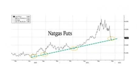


Looking across the Atlantic, colder weather and tight supplies sent Dutch natural gas for next month, the European benchmark, over the 100 euro mark and very close to the all-time highs witnessed early November:


If BAMWX calls for a ‘Polar Vortex’ play out, a monster reversal in U.S. natural gas futures will occur. And while this will be seen as good news for bullish traders, it will be bad news for consumers as bills soar and possible shortages ensue.


Latest BAMWX forecasts for ‘Polar Vortex’.

FEMA GUILTY OF TWISTER ‘CLIMATEERING’

Following the weekend’s deadly U.S. tornadoes, Federal Emergency Management Agency (FEMA) Administrator Deanne Criswell could’t miss out on an opportunity to play the AGW card, saying that extreme weather events like the storms and twisters that swept through a number of states this weekend “is going to be our new normal”.

“This is going to be our new normal and the effects that we’re seeing from climate change are the crisis of our generation,” Criswell told co-host Jake Tapper on CNN’s “State of the Union”–so credibility instantly lost then.

Severe storms and tornadoes tore through states in the South and Midwest late Friday into Saturday, leaving devastating damage, tens of thousands of homes without power and almost 100 people dead.

View: https://twitter.com/mitchell_knight/status/1469656473068265479
Run time is 0:35

This was a tragedy, undoubtedly — a truly hellish ordeal for those there; but to blame global warming and to climateer during such a disaster is disgusting, even by CNN standards.

These days, ‘progressives’ don’t hesitate to blame any kind of severe weather on AGW.

This is even though The Science that said alarmists repeatedly insist we follow states that tornadoes require unusually cool air to form. As climatologist and former NASA scientist Dr. Roy Spencer explains: Very few thunderstorms produce tornadoes. In the hot and humid tropics, they are virtually unheard of. The reason why is that (unlike hurricanes) tornadoes require strong wind shear, which means wind speed increasing and changing direction with height in the lower atmosphere — conditions that exist only when a cool air mass collides with a warm air mass–which is what occurred over the weekend:

View: https://twitter.com/extremetemps/status/1469759219599560709

The catastrophist caterwaulings of agenda-drivers like FEMA are opposed by scientific discovery and meteorological theory: This weekend’s collision of opposing air masses is actually better explained by low solar activity:


Alarmists do not get to alter known reality in order to advance their warped ideologies.

History will hold them to account.

The COLD TIMES are returning, the mid-latitudes are REFREEZING, in line with the great conjunction, historically low solar activity, cloud-nucleating Cosmic Rays, and a meridional jet stream flow (among other forcings).

Both NOAA and NASA appear to agree, if you read between the lines, with NOAA saying we’re entering a ‘full-blown’ Grand Solar Minimum in the late-2020s, and NASA seeing this upcoming solar cycle (25) as “the weakest of the past 200 years”, with the agency correlating previous solar shutdowns to prolonged periods of global cooling here.

Furthermore, we can’t ignore the slew of new scientific papers stating the immense impact The Beaufort Gyre could have on the Gulf Stream, and therefore the climate overall.


Prepare accordinglylearn the facts, relocate if need be, and grow your own.
 

TxGal

Day by day
Moscow Breaks Multidecadal Snowfall Records, "Tremendous Snow Totals" Hit Sierra Nevada Mountains, + Snowiest Greece Since 2004 - Electroverse

road-closed-e1639479284658.jpg

Extreme Weather GSM

MOSCOW BREAKS MULTIDECADAL SNOWFALL RECORDS, “TREMENDOUS SNOW TOTALS” HIT SIERRA NEVADA MOUNTAINS, + SNOWIEST GREECE SINCE 2004
DECEMBER 14, 2021 CAP ALLON

Dr. Richard Courtney: “The empirical evidence strongly indicates that the anthropogenic global warming hypothesis is wrong.”

MOSCOW BREAKS MULTIDECADAL SNOWFALL RECORDS

Much of transcontinental Russia has been holding exceptionally cold of late — from the far east to the far west, records have been falling, and now, so has the snow…

According to Phobos meteorologist Yevgeny Tishkovets, Moscow has busted multiple December snowfall records.
Back on Dec 7, the heaviest snowstorm in 72 years struck the Russian capital — not since 1949 had more snow settled this early in the season.

Then we have the accumulations over the weekend (Dec 11-12), which included the biggest single-day dumping since 1993.

And most recently, on Mon, Dec 13, we hear that 20+% of the city’s monthly snow has now fallen, thanks to largest December drop for the date since 1989.

View: https://twitter.com/singhpuru2202/status/1469496683956346880
Run time is 1:43

After a brief reprieve, Western Russia’s anomalous cold and snow is forecast to return with a vengeance on Dec 20:


GFS 2m Temperature Anomalies (C) Dec 20 – Dec 29 [tropicaltidbits.com]

In fact, much of Europe will be impacted — a scenario that threatens to further deplete already record-low energy supplies:


“TREMENDOUS SNOW TOTALS” HIT SIERRA NEVADA MOUNTAINS

Despite the CONUS holding unusually warm in recent weeks (a natural phenomenon btw), a powerful storm system has managed to tear across the Western U.S., including California where it’s dropping feet upon feet of snow on the Sierra Nevada.

The moisture-rich storm –a 3 on the UC San Diego Center for Western Weather and Water Extremes’ scale— was forecast to produce inches of much needed rain across the Bay Area, Mount Hamilton and coastal Monterey County, as well as feet of snow across the higher elevations:

View: https://twitter.com/capitalweather/status/1470448833717063688

View: https://twitter.com/NWS/status/1470430169437548544

And true to predictions, the Sierra Nevada mountains have indeed been pounded:

View: https://twitter.com/WeatherNation/status/1470528971032956939
Run time is 0:35

By Tuesday evening, 6+ feet of global warming goodness is expected to have accumulated in the Donner Pass and Lassen Volcano National Park, with a whopping 8+ feet on the Sonora, Carson and Ebbetts passes:

View: https://twitter.com/bclemms/status/1470495159188172812
Run time is 0:26

Lake Tahoe ski resorts, including Kirkwood Mountain Resort, have shut down operations until the heavy snowfall lets up, reports timesheraldonline.com. Kirkwood tweeted on Monday: “With 17 inches of snow overnight and high winds preventing snow safety and lift operations we will not be able to open today.”

The snow will gain ground eastwards as the week progresses, impacting most Western states by Thursday–and most every state by the end of the month:


GFS Total Snowfall (inches) Dec 14 – Dec 30 [tropicaltidbits.com].

And Christmas is currently setting up to be a frosty one, at least for the West:


GFS 2m Temperature Anomalies (C) Dec 25 – Dec 27 [tropicaltidbits.com].

SNOWIEST GREECE SINCE 2004

And finally, the month of December in Greece has already seen two “annual records for rainfall and snowfall” busted, according to the National Observatory of Athens, and as reported by ekathimerini.com.

By Dec 12, the annual rainfall reading at Theodoriana meteorological station reached 342.5cm (135 inches), exceeding a 15-year record. And by Dec 11, satellite data revealed that 19% of the country was under cover of snow, beating a 17-year record. Note: Greece’s average daily snow cover in early December is approx. 4%, added the observatory.

NH SNOW

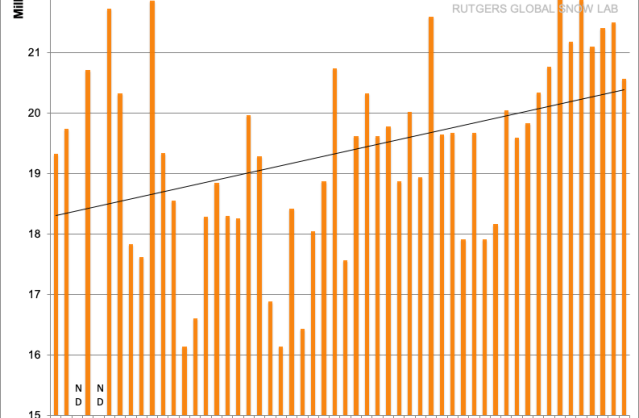
Taking a look at the FMI’s Northern Hemisphere Total Snow Mass chart (below), this season is progressing exceptionally well — snow mass has held above the 1982-2012 average all season, and is currently some 300Gts above the norm, and accelerating:


[FMI]

Furthermore, the global average temperature dropped 0.29C last month, and now stand at just 0.08C above the baseline:


–both are impossibilities under the original AGW hypothesis.

The COLD TIMES are returning, the mid-latitudes are REFREEZING, in line with the great conjunction, historically low solar activity, cloud-nucleating Cosmic Rays, and a meridional jet stream flow (among other forcings).

Both NOAA and NASA appear to agree, if you read between the lines, with NOAA saying we’re entering a ‘full-blown’ Grand Solar Minimum in the late-2020s, and NASA seeing this upcoming solar cycle (25) as “the weakest of the past 200 years”, with the agency correlating previous solar shutdowns to prolonged periods of global cooling here.

Furthermore, we can’t ignore the slew of new scientific papers stating the immense impact The Beaufort Gyre could have on the Gulf Stream, and therefore the climate overall.


Prepare accordinglylearn the facts, relocate if need be, and grow your own.
 

TxGal

Day by day
More bad news coming out of the devastating tornadoes of a few days ago (GSMs historically have increased and more intense storm activity):

Expect food prices further skyrocketing in the US after CHICKENS, TRACTORS AND GRAIN SILOS were destroyed by deadly U.S. tornadoes - Strange Sounds

Expect food price inflation skyrocketing in the US after CHICKENS, TRACTORS AND GRAIN SILOS were destroyed by deadly U.S. tornadoes
Dec 14, 2021

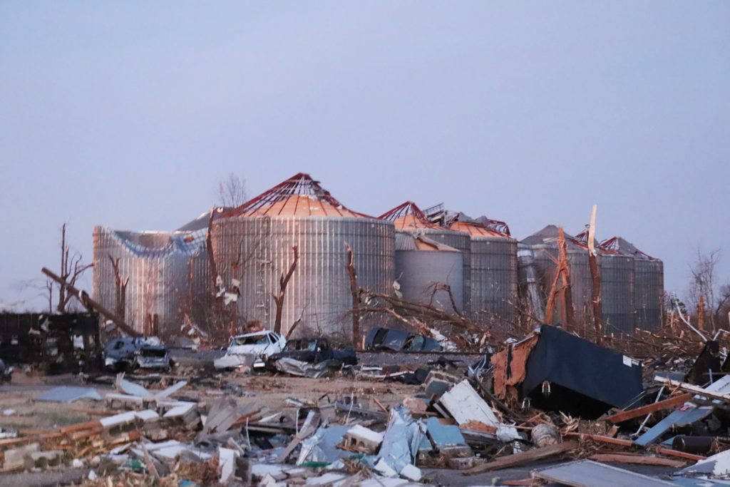
Tornado-damaged grain silos in Mayfield Graves County Kentucky
Tornado-damaged grain silos in Mayfield Graves County Kentucky. Picture by Steven Elder


The road to recovery will be long for farmers and ag businesses in western Kentucky following the storms that moved through late last week.

In Graves County, Mayfield, Kentucky, major agriculture companies were completely leveled, from a John Deere dealership to Mayfield Grain, which handles over 40 million bushels of grain every year. Moreover, Pilgrim’s Pride hatchery was wiped out in Graves County. That will have a ripple effect on the poultry production in Kentucky for some time to come.

We have a 200-mile swath through Kentucky that has pulled-down grain systems, destroyed chicken hatcheries and of course blown-over barns. When you have counties where the fences have been literally uprooted and tossed around, it’s going take some time to sort through animal losses. Simply because the cattle may not be there anymore. We’ve also secured holding facilities for cattle as well as horses,” said Ryan Quarles, Kentucky’s agriculture commissioner.

This first video shows a chicken hatchery & processing factory that has been completely destroyed by the December 10, 2021 Mayfield, Kentucky Tornado

View: https://youtu.be/mLfq6rXI9GM
Run time is 3:04

The destruction in the Midwest could further raise already high chicken prices and add to supply-chain headaches that have made it difficult for farmers to replace tractor parts.

Poultry is Kentucky’s top agricultural commodity, and at least a dozen chicken barns collapsed
, Quarles said. The state is working with the U.S. Environmental Protection Agency to properly kill and dispose of chickens housed in barns that were destroyed, he said.

President Joe Biden will visit the state on Wednesday to survey the damage.

One Pilgrim’s Pride chicken hatchery was a total loss, and another is expected to be offline until spring after suffering significant damage, the company said in a statement. It added that other company hatcheries are supplying chickens to farmers near Mayfield, a town of 10,000 that suffered some of the worst damage from the tornadoes.

Pilgrim’s, which is mostly owned by Brazilian meatpacker JBS SA, is evaluating damage to a local feedmill, while a production plant is expected to be fully operational on Wednesday, the statement said.

The loss of the hatchery in Mayfield “automatically triggers a multi-month delay in the processing and raising of chickens because the hatchery simply is not there anymore to supply the farmers,” Quarles said.

View: https://youtu.be/kNo0F9edeVk
Run time is 12:10

Mayfield is in Kentucky’s top county for agricultural sales, accounting for 6% of the state’s total farm business, according to U.S. Department of Agriculture data, though the state is not a top grain producer. Kentucky held 1.5% of U.S. corn stocks in December 2020, the USDA said.

Lots of farmer elevators damaged. Some small feed mills have damage with indefinite timelines,” said Andrew Jackson, broker at Producers Hedge, in Lancaster, Kentucky.

Mayfield Grain Company, a crop handler, had roofs ripped off of parts of a storage system that holds 6 million bushels of grain in Mayfield, Quarles said. That’s enough corn to fill two Panamax vessels – each ship the length of two football fields.

Photos on Twitter showed yellow corn visible from the tops of bins that lost their roofs. The company had no immediate comment.

View: https://twitter.com/bamwxcom/status/1470395984844922888

You have millions of bushels of corn, much of which was just freshly harvested, being exposed to the elements, being damaged,” Quarles said.

We’re looking for ways to recover spilled grain but also divert the storage and movement of grain to other facilities around the state.

View: https://twitter.com/cikrosintel/status/1470526933582716930

Quarles said the agriculture department will help farmers find buyers for grain amid reduced demand for feed from livestock and poultry producers who suffered losses.

Hutson Inc, a company that sells Deere equipment, said its flagship store in Mayfield was “destroyed by one of the worst natural disasters to ever hit the state.

Workers “waded through debris and used what equipment they could salvage to assist with rescue efforts at a candle plant located next to us that had mass casualties,” Chief Executive Josh Waggener said in a statement online.

Deere said it is in touch with Waggener and working with Hutson to provide financial assistance to the community. [Reuters, BrownFieldAGNews]

Discover terrifying pictures of these weaponized tornadoes here.

https://www.facebook.com/sharer.php...kyrocket-tornado-chickens-grain-tractors.html
 

TxGal

Day by day
Snowfall Records (from the 1800s) Fall In Nevada & California-Just As New Bogus Study Claims "No Snow" In 35 Years - Electroverse

no-snow.jpeg

Articles Extreme Weather GSM

SNOWFALL RECORDS (FROM THE 1800S) FALL IN NEVADA & CALIFORNIA–JUST AS NEW BOGUS STUDY CLAIMS “NO SNOW” IN 35 YEARS
DECEMBER 15, 2021 CAP ALLON

Dr. John Christy: “Little known to the public is the fact that most of the scientists involved with the IPCC do not agree that global warming is occurring. Its findings have been consistently misrepresented and/or politicized with each succeeding report.”

A parched Western U.S. has been buffeted by heavy precipitation this week, precipitation which fell as record-breaking snow across the region’s higher elevations as storm systems collided with descending Arctic air.

As I reported yesterday, snow has buffeted California’s Sierra Nevada this week, with as much as 8 feet has accumulating along the mountain chain, busting regional records. However, as the storm tracked east and entered the state of Nevada, it took out a number of historic snowfall records for the time of year.

Snow fell across Nevada on Tuesday, with the city of Elko picking up 3 inches. More impressive totals were registered elsewhere, though, including in the central Nevada towns of Ely, Eureka, Winnemucca and Tonopah, which all smashed snowfall records.

Winnemucca reported 5.5 inches of snow as of early Monday evening — a reading which busted the town’s previous all-time record for the date, the 3.4 inches set way back in 1889 (solar minimum of cycle 12–during the Centennial Minimum).

Ely logged 3.3 inches, with a water equivalent of .48 of an inch — this was almost double the old record set in 2012.

And Eureka’s .30 of an inch may seem paltry, but it’s still three times the previous record, which was set just last year, in 2020.

Despite the headaches such storms bring to a region, they have marked a meaningful change for a drought-parched West. And despite incessant claims of a “never-ending drought”, this week’s precipitation demonstrates, once again, that you should not make such grand calls when it comes to the climate — Cali’s water levels have now bounced “back to slightly above normal,” said David Gomberg, a meteorologist with the National Weather Service in Oxnard.

As a prolonged bout of low solar activity predicts (aka a ‘Grand Solar Minimum‘), a waning jet stream is throwing us all something of a curve ball: When solar activity is HIGH the jet stream is tight and stable and follows somewhat of a straight path, but when solar activity is LOW (as it is now) that meandering band of air flowing 6 miles above our heads becomes weak and wavy, it effectively buckles which either diverts frigid polar air to atypically low latitudes or warmer tropical air to unusually high latitudes. The jet stream reverts from a ZONAL flow to a MERIDIONAL flow and, depending on which side of it you’re on, you’re either in for a spell of unseasonably cold or hot weather and/or a period of unusually dry or wet conditions.


As well as the historic accumulations seen in Nevada, the storm has also dumped as much as 8 feet of snow between the Lake Tahoe area and Mammoth Mountain, and as much as 4 feet in the mountains around L.A. County — totals the Sierra Avalanche Center warn are overloading the existing snowpack, increasing the likelihood of “very wide avalanches”.

Laughably, these healthy falls have arrived hot on the heels of a new study which claims snow in the Sierras could be all-but gone in just a few short decades, which would result in disaster for California’s water supply. Should greenhouse gas emissions continue unabated, the study goes, winters of low snow, or even no snow, could become a regular occurrence in as little as 35 years.

View: https://twitter.com/WeatherNation/status/1470846058527924233
Run time is 1:24

But as is the case with all modern climate research, the study is built entirely on the presumption that Earth is warming in line with increasing atmospheric CO2 levels–there now being no other way to obtain funding. The paper states that increasing temperatures will mean more precipitation falling as rain instead of snow, “and rain has less water storage potential than its colder counterpart,” points out Alan Rhoades, a hydroclimate research scientist and co-author of the study.

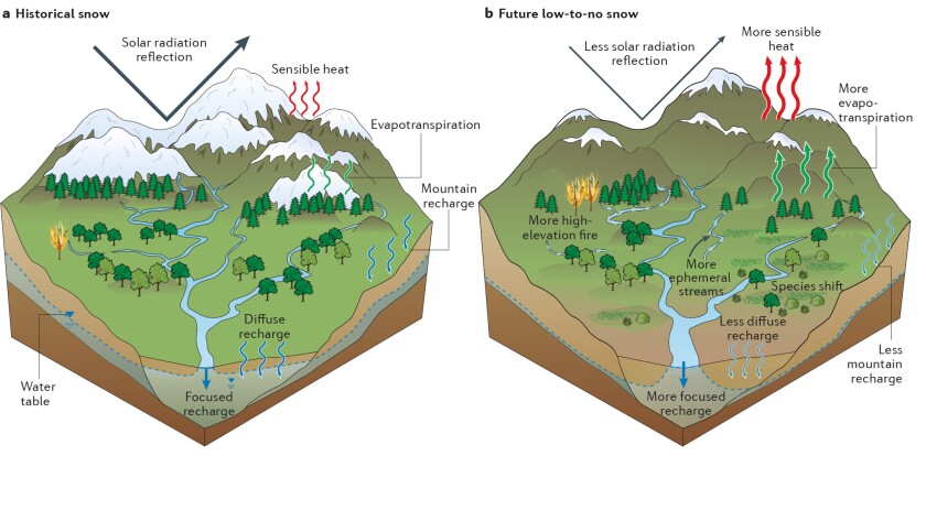
The researchers have an even supplied a patronizing little graphic–presumably for the logically-impaired (aka MSM journalists):

Researchers demonstrated how the West's mountain environments could change under persistent low- to no-snow conditions
‘More snow on left = good, less snow on right (plus two trees on fire) = bad’.

Only later in the paper do the researchers reveal that their findings were primarily based on “a high-emission scenario that is not yet inevitable”, and even less ink is given to the genuine problems re California’s water supply: management.

“Decreasing snowpack is just one of several challenges facing California water managers, including aging infrastructure and declining ecosystem health,” said John Andrew, deputy director of climate resilience at the California Department of Water Resource — a looming reality which lead Gov. Gavin Newsom to allocate more than $5 billion of his $15-billion ‘climate package’ toward drought response and water resilience.

“Water conservation should be a way of life in California,” added Andrew.

View: https://twitter.com/WeatherNation/status/1471072554643189762
Runtime is 0:57

The projections of no snow “are a little bit shocking,” said Rhoades of the study’s findings.

“As a kid who grew up in the Sierra, it’s kind of hard to fathom a low- to no-snow future.”

Indeed it is…

View: https://twitter.com/bclemms/status/1470495159188172812
Run time is 0:26

…and we haven’t even hit winter yet.

The purity of the idiocy at play here –and from supposedly highly-educated people, too– knows no bounds. Researchers like Rhoades are puppets of the AGW Party, whether they know it or not, and they have clearly learned nothing from the long list of prophetic failures of yesteryear.

You cannot put a date on the EOTW.

You will always end up with egg on your face:


Also see ‘Northern Hemisphere Snow Mass Marches On’:


And lastly, Rhoades et al clearly haven’t even bothered to check if the planet is still actually warming:


We are being lied to on every front.

A healthy suspicion is advised.

Stay free.

The COLD TIMES are returning, the mid-latitudes are REFREEZING, in line with the great conjunction, historically low solar activity, cloud-nucleating Cosmic Rays, and a meridional jet stream flow (among other forcings).

Both NOAA and NASA appear to agree, if you read between the lines, with NOAA saying we’re entering a ‘full-blown’ Grand Solar Minimum in the late-2020s, and NASA seeing this upcoming solar cycle (25) as “the weakest of the past 200 years”, with the agency correlating previous solar shutdowns to prolonged periods of global cooling here.

Furthermore, we can’t ignore the slew of new scientific papers stating the immense impact The Beaufort Gyre could have on the Gulf Stream, and therefore the climate overall.


Prepare accordinglylearn the facts, relocate if need be, and grow your own.
 

TxGal

Day by day
Increased volcanic activity and the subsequent ash is frequently discussed as a contributor to the GSM:

With just weeks to go until 2022, the Ring of Fire is suddenly ROARING to life -- Earth Changes -- Sott.net

With just weeks to go until 2022, the Ring of Fire is suddenly ROARING to life

Michael Snyder
End of the American Dream
Sun, 12 Dec 2021 00:00 UTC

Ring of Fire
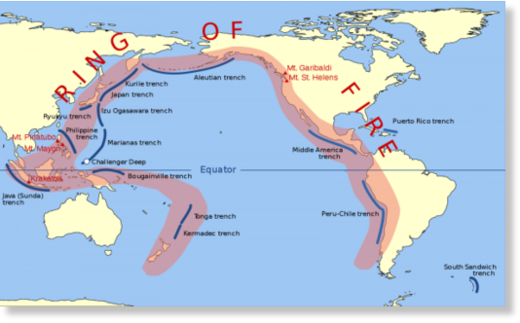
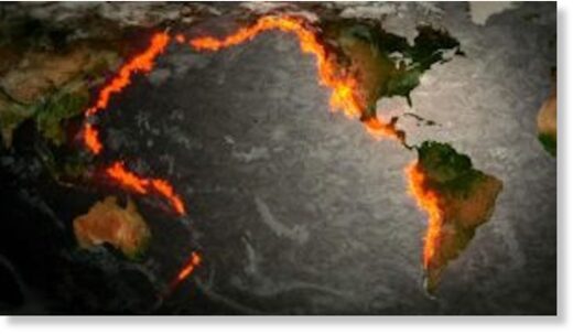
Why are so many earthquake swarms suddenly happening all along the Ring of Fire? For those that don't know, the Ring of Fire is a series of fault zones that run roughly along the perimeter of the Pacific Ocean. 75 percent of the Earth's active volcanoes are located within the Ring of Fire, and it accounts for more than 80 percent of all global earthquakes. So the fact that the Ring of Fire is starting to become so active should definitely trouble us all.
As I write this, we are less than three weeks away from 2022.

And as I have expressed on numerous occasions, I have such a bad feeling about 2022.

So many pieces of the puzzle are starting to come together, and that includes an alarming rise in seismic activity.

Let me start by discussing what just happened in Oregon. Starting last Tuesday and continuing through Wednesday, we witnessed a very strange swarm of earthquakes along the Blanco Fault Zone...
Nearly 250 miles west of Newport, Oregon, a place called the Blanco Fracture Zone has produced more than 60 earthquakes in 36 hours.

"About 20 of them, oh, we just had another one just now, about 21 of them are over magnitude 4.7," said Chris Goldfinger of Oregon State University.
The biggest quake in that swarm was a magnitude 5.8, and it had many wondering whether the nearby Cascadia Subduction Zone could be affected.

Needless to say, a major quake along the Cascadia Subduction Zone would be a really big deal, because it could potentially send a giant tsunamislamming into the west coast...
Meanwhile, the Oregon Office of Emergency has warned if a powerful 9.0+ magnitude earthquake originates from the Cascadia Subduction Zone, it could unleash a "tsunami of up to 100 feet in height that will impact the coastal area."

The state agency adds, "Currently, scientists are predicting that there is about a 37 percent chance that a megathrust earthquake of 7.1+ magnitude in this fault zone will occur in the next 50 years."
Unfortunately, the odds of such an event happening are much greater than 37 percent.

And one prominent scientist has just discovered that a major quake along the Cascadia Subduction Zone could also potentially trigger a quake along the San Andreas fault...
The two faults meet in an area known as the Mendocino Triple Junction. Now, Goldfinger has found evidence that a quake on one could trigger a quake on the other, in essence making for one giant seismic event that would span the entire west coast of the U.S.

The new results stem from the analysis of sediment cores from the Mendocino Triple Junction area. Those cores, pulled from canyons on the ocean floor, show evidence of earthquakes in the form of underwater landslides. Using carbon dating, Goldfinger found that nearly a dozen earthquakes occurred throughout history on both faults at the same time.
Let us hope that something like that doesn't happen any time soon.

2022, The Ring Of Fire
Getting back to current events, another disturbing swarm of earthquakes just hit the Rat Islands along the southern coast of Alaska...
The Rat Islands are part of the Aleutian Islands, a chain of volcanic islands, that results from the subduction of the Pacific Plate beneath the North American Plate.

This plate boundary, the Alaska-Aleutian megathrust, has been the location of many megathrust earthquakes. The latest occurred in on February 4, 1965.

Today, more than 15 earthquakes have rattled the same area.
Of course the entire southern coast of Alaska is included in the Ring of Fire, and at this point the seismic activity up north has become so frequent that it never seems to stop.

Meanwhile, an even more alarming swarm of earthquakes just shook Japan. The following comes from our colleagues over at Zero Hedge...
Quakes first hit Mount Fuji around Dec. 3. The seismic activity continued days later. On Dec. 7, more than 200 quakes were reported across the Tokara Islands. The largest was a 4.8 magnitude.

One poster on the Yahoo Japan news website said, "heard a report that the 'Big One' will happen this month, so I am being cautious."

The Meteorological Agency doesn't know what is causing the quake storm, but we've shown before that quake swarming near a volcano has preceded an eruption (read: here).
How many years have I been warning about Mt. Fuji?

The fact that earthquakes are now shaking the volcano is a very troubling sign.

One of these days Mt. Fuji is going to blow, and when that happens you will not want to be anywhere around.

Speaking of eruptions, volcanoes in Ecuador, Peru, Guatemala, Chile and Indonesia all sent ash high into the sky over the weekend.

Needless to say, all of those mountains sit along the Ring of Fire.

I know that a lot of people don't like when I say this, but the truth is that our planet is becoming increasingly unstable.

On Friday, we witnessed a very painful example of this here in the United States. The worst tornado disaster in the history of the state of Kentucky killed dozens of peopleand flattened countless buildings...
More than 80 people in Kentucky were killed after tornadoes ripped across several U.S. states late Friday.

"I know we've lost more than 80 Kentuckians. That number is going to exceed more than 100. This is the deadliest tornado event we've ever had," Governor Andy Beshear said on CNN Sunday morning.
You can see video footage of the devastation here and here. Overall, six states were affected by the tornadoes that were spawned, and it has been documented that one family photo was sent flying 130 miles away...
The twisters that spread death and destruction across six states on Friday night were powerful enough to send a family photo flying 130 miles and derail a freight train in western Kentucky, which bore the brunt of the horrific storm.

As the sun rose on Sunday morning, survivors picked through the rubble to salvage anything they could in near-freezing temperatures, still shell-shocked at the scope of death and devastation and many without electricity or running water.
Unfortunately, this is just the beginning.

Our planet is going to continue to become more unstable, and we are going to see more horrific natural disasters in 2022 and beyond.

With the Ring of Fire now becoming so active, those living on the west coast should particularly be on alert.

Scientists have been warning us that "the Big One" is way overdue, and at some point time will have run out and it will finally be here.
 

northern watch

TB Fanatic
"Historic" Wind Storm Could Produce Rare Tornado Threat In Central US

BY TYLER DURDEN
ZERO HEDGE
WEDNESDAY, DEC 15, 2021 - 03:46 PM

Last week's tornado outbreak left dozens dead and towns devastated across six states could happen again. The National Weather Service (NWS) warned Wednesday morning that "another historical weather day" is imminent for the Midwest.

2021-12-15_09-58-59.png


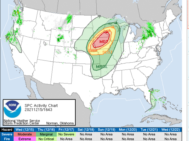
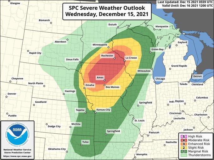
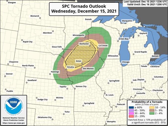
NWS said a severe weather threat is slated for later today into tonight across the Mid-Missouri Valley to the Upper Mississippi Valley. "Embedded gusts of 75-100 mph and a strong tornado or two are also possible, particularly from extreme eastern Nebraska across western to northern Iowa and southeastern Minnesota," the weather agency said.

In a series of tweets, NWS outlines how "another historical weather day is forecast today with two never-before-seen outlooks issued." First, a moderate risk (4/5 on the severity scale) of life-threatening weather has been declared for parts of Iowa, Minnesota, and Wisconsin. The weather agency said this is the first time that it published such an alert for those states in December.

nws%20map.jpg


The highest tornado risk appears to be across much of Iowa. "All of this will likely be occurring AFTER DARK, so make your preparations now and follow severe weather alerts," NWS said.

nws%20twister.jpg


"The Central U.S. has never seen a December storm like this," tweeted MSNBC meteorologist Bill Karins. "Multi-hazard, life-threatening weather today."

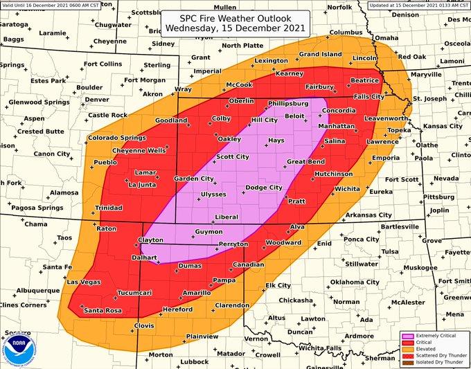
At the same time, Southern and Central Plains states are plagued with the first "extremely critical" fire outlook, the first in NWS' history for December.

nws%20fire%20risk.jpg


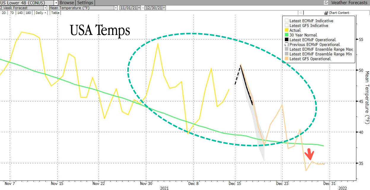
All of this is occurring as temperatures across the U.S. have been mild.

2021-12-15_10-15-21.png


Stay tuned for weather updates this evening and into the overnight.

"Historic" Wind Storm Could Produce Rare Tornado Threat In Central US | ZeroHedge
 
Last edited:
Top