Solar Grand Solar Minimum part deux

TxGal

Day by day
Adapt 2030 has a new podcast out:

Changes Hidden in Plain Sight - YouTube

Changes Hidden in Plain Sight
21,208 views
Oct 1, 2021

View: https://youtu.be/G2jzQwncHyc
Run time is 10:36

Synopsis provided:

Largest electric jet ever sighted in Puerto Rico resembling canyon wall petroglyphs. Northern Hemisphere melt season comes to an end with Greenland and Arctic sea ice levels well above lows experienced in the early 2000's. Antarctic sea ice above average all S. Hemisphere winter . China's corn imports up 221%, early onset of record cols and snow N. Hemisphere.
 

TxGal

Day by day
Dr. Roger Higgs Exposes "Breathtaking Scale of NASA-HadCRUT Temperature-Fixing Fraud" - Electroverse

sun-and-ocean-2-e1633337068707.jpg

Articles
DR. ROGER HIGGS EXPOSES “BREATHTAKING SCALE OF NASA-HADCRUT TEMPERATURE-FIXING FRAUD”
OCTOBER 4, 2021 CAP ALLON

Geoclastica Ltd Technical Note 2021-6 Dr Roger Higgs (DPhil, Oxford, Geology) 28 Sept 2021, amended 2 Oct 2021.

Below is Dr. Roger Higgs’ newest ResearchGate contribution — comprised of 4 simple slides (a 15 minute read) proving beyond doubt that the Sun governs climate.

“The slides reveal the breathtaking scale of NASA-HadCRUT temperature-fixing fraud,” writes Dr. Higgs.
“You will be shocked,” he continues.

“To see the monumental scale of the deception laid bare as I assembled this new contribution over the last few days made my jaw drop. I am disgusted. How dare these unscrupulous people commit this appalling crime against humanity, i.e. manipulating the global thermometer data to ‘justify’ a drastic restructuring of world society (The Great Reset) and the denial of life-prolonging reliable energy to billions of impoverished citizens of developing nations?”

SLIDE 1 — CONCLUSIONS:

1) Our star, the Sun, controls global (& regional) warming & cooling, with 150-year delay due to ocean thermal inertia. (IPCC failed to notice this lag & dismissed solar fluctuations as too small to cause climate change.)

2) ‘Modern Warming’ since 1910 (recovery from Little Ice Age) is greatly exaggerated by NASA-HadCRUT improper ‘corrections’ to the thermometer record, e.g. failure to compensate fully for urbanization. This solves the tree-ring Divergence Problem: “A temperature trend extracted from tree rings alone would not show any substantial warming since the 1950s”.

3) The 1930’s (Dust Bowl) was probably the warmest decade of the last 1,000 years; it corresponds to the climax of the Sun’s 1700-1780 strongest multi-decade surge of the 2nd Millennium (effect delayed 150 years).

4) The joint rise in both CO2 (since 1850, start of Industrial Revolution) & temperature (since 1910, with downturns lacked by CO2, and without CO2’s acceleration) was purely coincidental.

5) Following the 2016 temperature peak, relative coolness will now persist for about 50 years.

6) CO2 is irrelevant to climate. (We need more CO2 for agriculture & forestry).

7) CO2’s theoretical greenhouse effect must be either conceptually flawed or is cancelled by negative feedbacks overlooked or ignored by IPCC.

SLIDE 2 – OBVIOUS CORRELATION OF SUN & TEMP, LAST 1000 YEARS:


[Dr. Higgsclick image to enlarge]

SLIDE 3 – MANIPULATION OF THERMOMETER DATA, LAST 150 YEARS:


[Dr. Higgsclick image to enlarge]

SLIDE 4 – CO2 NON-CORRELATION WITH GLOBAL TEMPERATURE, LAST 2000 YEARS & LAST 150 YEARS


[Dr. Higgsclick image to enlarge]

This new contribution will make for interesting discussion at the imminent United Nations 26th Climate Change Conference (Glasgow, Oct 31 – Nov 12, 2021), titled ‘Uniting the World to Tackle Climate Change” (ukcop26.org). What a complete and utter farce: not only is Earth now cooling (again), but how does one ‘tackle’ solar variations?

Please share Dr. Higgs’ work widely, especially to teachers, journalists and politicians.

Website/blog owners are urged to email Higgs for the original high-res pptx versions of the 4 slides.

Truth must win.


The COLD TIMES are returning, the mid-latitudes are REFREEZING, in line with the great conjunction, historically low solar activity, cloud-nucleating Cosmic Rays, and a meridional jet stream flow (among other forcings).

Both NOAA and NASA appear to agree, if you read between the lines, with NOAA saying we’re entering a ‘full-blown’ Grand Solar Minimum in the late-2020s, and NASA seeing this upcoming solar cycle (25) as “the weakest of the past 200 years”, with the agency correlating previous solar shutdowns to prolonged periods of global cooling here.

Furthermore, we can’t ignore the slew of new scientific papers stating the immense impact The Beaufort Gyre could have on the Gulf Stream, and therefore the climate overall.


Prepare accordinglylearn the facts, relocate if need be, and grow your own.
 

TxGal

Day by day
In these Days of "Catastrophic Global Warming," the South Pole just suffered its Coldest 'Winter' in Recorded History - Electroverse

the-south-poles-e1633344801853.jpg

Articles Extreme Weather GSM

IN THESE DAYS OF “CATASTROPHIC GLOBAL WARMING,” THE SOUTH POLE JUST SUFFERED ITS COLDEST ‘WINTER’ IN RECORDED HISTORY
OCTOBER 4, 2021 CAP ALLON

Contrary to the MSM’s agenda-driven narrative, the South Pole has been suffering unprecedented cold this year.
Between the months of April and September, the South Pole averaged a temperature of -61.1C (-78F).

Simply put, this was the region’s coldest 6-month spell ever recorded, and it comfortably usurped the previous coldest ‘coreless winter‘ on record — the -60.6C (-77F) set back in 1976 (solar minimum of weak cycle 20).

This incredible and AGW-destroying reality is confirmed by Antarctica climatology journalist Stefano Di Battista who has closely watched and published research on Antarctic temperatures for many years:

View: https://twitter.com/pinturicchio_60/status/1443907726359339032


Battista also points out that for June, July, August and September the average temperature for each of these month finished-up below -60C (-76F) — a phenomenon that has occurred on just 3 previous occasions: in 1971, 1975 and 1978.

It has long been proposed that this upcoming bout of low solar activity (Grand Solar Minimum) will commence with a return to the historically cold winters of the 1970s — and here we are. Unfortunately, it’s only downhill from here:


A similar story is playing out at the North Pole, too.

The natural and slight warming trend observed over the past few decades is over: climate is cyclic, never linear, and trends change. And in line with this returning chill, Arctic Sea Ice is also on a sharp uptick this year, as visualized in the NASA chart below:


[NASA]

Anthropogenic Global Warming (AGW) is a control mechanism.

It is a divisive, terrifying theory–and one they have the gall to blame entirely on us humans (which in itself is absurd).

AGW is ideal for advancing their overarching Great Reset agenda, which includes depopulation. They are breeding a culture of fear within the general public in order to achieve political goals via emotional bias.

Our children being the most susceptible to this kind of game-playing is no accident. But for all you adults still being manipulated by this ‘button-pressing’, the data is readily available for you to thoroughly evaluate. To ignore facts and logic, and to instead blindly believe the picture painted by those with vested interests shows a powerful ignorance, and cowardice.

How is it that a person can on the one hand harbor a distrust for politicians/politics, yet on the other unquestioningly believe what governmental bodies/scientists are telling them? How can it be widely accepted that governments are lobbied by powerful multinational corporations, yet when it comes to questions around the efficacy or even the need for a vaccine –for example– we all shut up?

There are powerful silencing tactics at play, driven by fear.

Added to that, most people have mastered the art of cognitive dissonance.

But it stands, asking pertinent questions is NOT the same as pushing mindless conspiracy theories. There are far too many coincidences for current events to be legit. The world is slowly waking up to their intentions — but as punishment, we’re now under their thumb more than ever. As the Chinese Communist Party is currently demonstrating, maintaining power is all that matters — power takes precedence over the health of the economy and the ‘happiness’ of the people, because once you have an authoritarian grip on the 80%, it’s game over for EVERYONE.

Fight for the truth — history reveals it always wins out… eventually.
 

summerthyme

Administrator
_______________
Just a short note - I may not be doing a lot of posting this week, please feel free to post whatever you all find that fits in with the GSM.

I seem to have a good case of eye strain from too much computer time, and need to cut back a bit.
Do you use a blue blocker app or program for your screens? It's made a huge difference for me, especially at night.

Summerthyme
 

TxGal

Day by day
Do you use a blue blocker app or program for your screens? It's made a huge difference for me, especially at night.

Summerthyme
Thanks, Summerthyme, I'll check that out! My DD just got one for her work computer, I probably should, too! I need to get this checked out, really. Just one eye is affected, but I felt a strain when I was playing Mahjong on the computer, over and over. Then it got pretty bloodshot on the inner side. It's a bit better now, but I can still feel it's 'off' - fortunately my vision isn't affected.
 

TxGal

Day by day
From electroverse.com (please note that the author plopped a bit about covid in the article along with the new Project Veritas video....and yes, as he mentioned, I'm one of those who wishes he'd just stick to the GSM.)

Northern Hemisphere 'Snow Mass Season' Opens 250 Gigatons ABOVE 1982-2012 Average - Electroverse

Becca-Sept.-25-e1633424993286.png

Extreme Weather GSM

NORTHERN HEMISPHERE ‘SNOW MASS SEASON’ OPENS 250 GIGATONS ABOVE 1982-2012 AVERAGE
OCTOBER 5, 2021 CAP ALLON

This first observations for the FMI’s “Total Snow Mass For The Northern Hemisphere” chart have just been plotted, and as occurred in previous years, the season has opened well-above the 30 year average.

The opening data-point for the 2021-22 season is approximately 250 Gigatons above the 1982-2012 average, proving once again that IPCC prophesies of decreasing snow cover were formed on flawed foundations:


Red ‘un-circled’ dot indicates opening of the season, at 250 Gts above the average [FMI].

The second data point (from Oct 3) has seen a notable decrease–but only to a level that is still above the upper SD band.

Historically, there can be some flip-flopping at this time of year, and we’ll have to wait a number of weeks before things settle and a trend can be determined. Saying that though, it is certainly safe to speculate that this season will be another explosive one in terms of snow cover–akin to last year (shown below): we can assume this because of 1) the historically low solar activity we’ve experienced of late its impact on global average temperatures, and 2) the multi-year trend of growth developing on ALL of the snow cover charts–such as the FMI’s that I use here (but there’s also ECCC’s, among others, which paint the same picture).


Peak of 2020-21 season [FMI].

This upcoming Northern Hemisphere winter has long been predicted to be a doozy, and while the MSM scrambles to find any and every explanation to support their failing ‘catastrophic global warming’ hypothesis (i.e. warming = cooling), what is far more likely, based on the actual data, is that planet earth is on the cusp of its next great cooling epoch — a Grand Solar Minimum.

The first observations from this season’s FMI Total Snow Mass chart support this.

As does the global temperature drop which began in 2016:


As does the fact that the South Pole recently experienced its coldest 6-month spell in recorded history, busting the previous benchmark held by 1976–a year which lands during the deep solar minimum of the historically weak solar cycle 20:


And then we have the SMB trend-reversal on Greenland, which also began in 2016.

The world’s largest island has experience a string of healthy Surface Mass Balance seasons in recent years during which snow and ice accumulated at levels comfortably above the 1981-2010 average used by the Danish Meteorological Institute (DMI):


Don’t fall for the controlling political agendas of the day.

History won’t remember you fondly.

And on that note, and at risk of further-annoying those imploring me to stick to issues regarding ‘climate’, the COVID debacle is tracking a very similar narrative. Please watch the latest Project Veritas exposé (released today) to hear what Pfizer scientists actually think of their own vaccine:

View: https://youtu.be/On5RYFbcxWY
Run time is 10:06

The COLD TIMES are returning, the mid-latitudes are REFREEZING, in line with the great conjunction, historically low solar activity, cloud-nucleating Cosmic Rays, and a meridional jet stream flow (among other forcings).

Both NOAA and NASA appear to agree, if you read between the lines, with NOAA saying we’re entering a ‘full-blown’ Grand Solar Minimum in the late-2020s, and NASA seeing this upcoming solar cycle (25) as “the weakest of the past 200 years”, with the agency correlating previous solar shutdowns to prolonged periods of global cooling here.

Furthermore, we can’t ignore the slew of new scientific papers stating the immense impact The Beaufort Gyre could have on the Gulf Stream, and therefore the climate overall.


Prepare accordinglylearn the facts, relocate if need be, and grow your own.
 

TxGal

Day by day
Oppenheimer has a new podcast out:

Major Snow Threatens The West & Rockies - Iceland Earthquake Swarm Ongoing - Solar Cycle 25 Update - YouTube

Major Snow Threatens The West & Rockies - Iceland Earthquake Swarm Ongoing - Solar Cycle 25 Update
6,288 views
Premiered 19 hours ago

View: https://youtu.be/CIPmlZJrkeM
Run time is 9:32

Synopsis provided:

Flooding, forecast across Southeast - California, Rockies to see snow https://fxn.ws/3aoDEDb
Hail pounds Disneyland amid bizarre weather in Southern California https://bit.ly/3iAYZxp
Fairbanks sees significant early season snow event https://bit.ly/3BfkKKE
Cleveland’s winter forecast includes shivering temps and lake-effect snow https://bit.ly/3Ag8k3P
Above average snow and cold predicted for this winter, according to AccuWeather https://bit.ly/3Fnc47h
NORTHERN HEMISPHERE ‘SNOW MASS SEASON’ OPENS 250 GIGATONS ABOVE 1982-2012 AVERAGE https://bit.ly/3BhD9Xk
Flash Flood Threat across the Southeast; Record Heat and Fire Weather Concerns for Northern Plains https://www.weather.gov/
Environment Canada issues snowfall warning for the B.C. Peace and Pine Pass https://bit.ly/3lcLgyP
GFS Model Total Snow US https://bit.ly/3Dhc3jI
Hail and wild winds lash Melbourne suburbs https://bit.ly/3uPRmbp
Victoria hit by ‘significant’ hail, damaging winds on the way https://bit.ly/2ZPuLQK
IN THESE DAYS OF “CATASTROPHIC GLOBAL WARMING,” THE SOUTH POLE JUST SUFFERED ITS COLDEST ‘WINTER’ IN RECORDED HISTORY https://bit.ly/2YhX8q3
La Palma volcano eruption already biggest on the island in more than 100 years https://bit.ly/3FncOcz
Krísuvík volcano (Iceland): intense seismic activity, more than 1000 quakes https://bit.ly/2YmMzCh
Ongoing earthquake swarm close to Keilir mountain https://icelandgeology.net/
Iceland Earthquake Map https://en.vedur.is/earthquakes-and-v...
DR. ROGER HIGGS EXPOSES “BREATHTAKING SCALE OF NASA-HADCRUT TEMPERATURE-FIXING FRAUD” https://bit.ly/3a8vGh5
New study says cosmic acceleration and dark energy don’t exist https://bit.ly/3Bih1vN
 

TxGal

Day by day
Solar Cycle 25 Progressing Similarly to 24, + Fairbanks sees Record-Breaking Snowfall - Electroverse

comparison_recent_cycles-1-e1633513853882.png

Articles Extreme Weather GSM

SOLAR CYCLE 25 PROGRESSING SIMILARLY TO 24, + FAIRBANKS SEES RECORD-BREAKING SNOWFALL
OCTOBER 6, 2021 CAP ALLON

Although slightly outperforming SC24, Solar Cycle 25 is currently progressing as expected: the cycle is on course to be another historically weak one, markedly lower than SC21, SC22 and SC23 — this means a persisting migraine for the AGW Party as global temperatures are only set to continue their well-established correlation with solar activity.


Solar Cycle 25 progression (green line) compared to 24, 23, 22 & 21 [updated Oct 1, 2021 — solen.info]

Below is a chart comparing Solar Cycle 25 to the very weak cycles from the turn of the 1900s (the Centennial Minimum):


Solar Cycle 24 & 25 compared to 16, 14, 13 & 12 [updated Oct 1, 2021 — solen.info]

Clear to see is just how lackluster these past two cycles are proving to be — they are the weakest in more than two centuries:

ises-solar-cycle-sunspot-3.png

[swpc.noaa.gov]

The official forecast by the NOAA/NASA Solar Cycle 25 Prediction Panel (made in 2019, and visualized by the red line above) called for a weak cycle 25, peaking in July 2025. And while things are currently tracking slightly ahead of schedule, NOAA don’t believe that the cycle will peak any higher than SC24. Instead, they simply see the peak arriving earlier, in late-2024 (rather than mid-2025). If this plays out it would of course mean an earlier start to Solar Cycle 26, too–a cycle, according to many predictions, that may struggle to produce many sunspots at all — an eventually that could usher in the next Grand Solar Minimum proper.

As always, time will tell.

Stay tuned.

FAIRBANKS SEES RECORD-BREAKING SNOWFALL

Winter is off to a strong start in Fairbanks, after a snow event that began Friday and lasted through Sunday caused an unusually large amount of snow for this time of the year.

Fairbanks set a pair of daily snowfall records and, even more impressive, the two-day and three day snow accumulations were among the highest on record for this early in the season.

View: https://twitter.com/CBSNews/status/1444361569815650314
Run time is 0:17

Friday and Saturday were both record setting days for Fairbanks, according to the National Weather Service (NWS).

Fairbanks received 3 inches of snow on Friday, busting the previous record of 2.4 inches set way back in 1916 (the Centennial Minimum). While the 2.8 inches recorded on Saturday broke the record of 2.1 inches from 1944 (solar minimum of cycle 17).

View: https://twitter.com/NWSFairbanks/status/1444820368355594243

In more than a century of book-keeping, this combined total of 5.8 inches is the sixth greatest two-day accumulation on record for this early in the season.

Additionally, the three-day total for Friday through Sunday closed at 6.7 inches — the fifth highest for the early season.

For reference, the NWS defines Sept 1 to Oct 5 as ‘the early season’.

In terms of total snow accumulation, the weekend event was “very significant,” said climatologist Rick Thoman. According to Thoman, the two and three day accumulations are more notable than the daily records — there are more multiple day stretches of snow, he explained, and so these records are much harder to break.

The early blast of winter wasn’t just confined to Fairbanks, either — vast swathes of Interior Alaska copped inches and inches of global warming goodness:

View: https://twitter.com/NWSFairbanks/status/1444460617234976772

It’s also beginning to look a lot like winter on Mount Washington, reports comoxvalleyrecord.com.

Around 1.6 inches of snow had accumulated Tuesday morning, Oct 5.

And looking ahead, The Weather Network expects further light dustings on the mountain as the week progresses, with another round of potentially heavier snow rolling through on Sunday as overnight lows sink to 24.8F (-4C).

A potent Pacific system is pushing on the B.C. coast, continues the comoxvalleyrecord.com article, and higher elevations are forecast as much as 8 inches (20 cm) of snow — a snowfall warning is in effect for the Peace River region, but with a northwest flow, freezing levels have dropped significantly: the average south coast peaks freezing level for October is just under 9,800 ft (3,000 m); but this coming Sunday and Monday, levels are expected drop to around 3,900 ft (1,200 m).


The COLD TIMES are returning, the mid-latitudes are REFREEZING, in line with the great conjunction, historically low solar activity, cloud-nucleating Cosmic Rays, and a meridional jet stream flow (among other forcings).

Both NOAA and NASA appear to agree, if you read between the lines, with NOAA saying we’re entering a ‘full-blown’ Grand Solar Minimum in the late-2020s, and NASA seeing this upcoming solar cycle (25) as “the weakest of the past 200 years”, with the agency correlating previous solar shutdowns to prolonged periods of global cooling here.

Furthermore, we can’t ignore the slew of new scientific papers stating the immense impact The Beaufort Gyre could have on the Gulf Stream, and therefore the climate overall.


Prepare accordinglylearn the facts, relocate if need be, and grow your own.
 

TxGal

Day by day
Siberia set for extreme winter deep freeze, Russian experts predict, as Europe faces energy shortages with cooler weather on way -- Earth Changes -- Sott.net

Siberia set for extreme winter deep freeze, Russian experts predict, as Europe faces energy shortages with cooler weather on way

RT
Mon, 04 Oct 2021 06:47 UTC

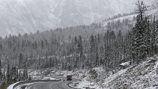
A truck drives along the M54 'Yenisei' highway
© REUTERS/Ilya Naymushin
A truck drives along the M54 'Yenisei' highway during a snowfall in the Western Sayan mountains in Southern Siberia near an administrative border with Tuva region, Russia, October 6, 2015.

One of Russia's top forecasters has warned that extreme weather is predicted to hit the Northern Hemisphere later this year, sparking concerns that it could worsen a deepening energy crisis setting in across parts of Europe.

Harsh conditions are predicted to hit Russia in early January, with snow in Siberia estimated to reach levels twice as severe as the average. On Monday, the meteorological center Phobos also reported that "snowdrifts almost a quarter larger than the norm" could sweep across Moscow.

In recent weeks, much of Western Europe has seen a rapidly growing energy crisis, with some parts of the continent experiencing a 250% increase in the price of gas for the heating and fuelling industry. Petrol stations in the UK running dry faster than they can secure new deliveries have caused severe delays and fights breaking out at refill forecourts.

There are, however, signs that a difficult winter could cause the continent to slip deeper into an even worse energy catastrophe. Simon Thorne, the UK's global director of generating fuels at S&P Global Platts, has said that "the savior likely comes in a milder winter. That would make a difference. But a very cold winter would be disastrous for many - even marginally cold would be very difficult."

Russia's president, Vladimir Putin, said earlier this year that a series of increasingly extreme weather events, including devastating wildfires and floods, are "at least to a large extent due to global climate change in our nation." Putin also told US climate envoy John Kerry that Russia and the US have "common interests" when it comes to combating climate change in a move to team up against global warming, and the pair agreed to work together to improve the situation.

Comment: See also:
 

TxGal

Day by day
Northern Hemisphere Predicted an "Extreme Deep Winter Freeze" by one of Russia's Top Forecasters, a Foot of Early-Season Snow Hits the Alps, as Gas Prices Surge Another "Astonishing" 30% - Electroverse

Snow-Alps-Oct-2021-e1633600883328.png

Articles Extreme Weather GSM

NORTHERN HEMISPHERE PREDICTED AN “EXTREME DEEP WINTER FREEZE” BY ONE OF RUSSIA’S TOP FORECASTERS, A FOOT OF EARLY-SEASON SNOW HITS THE ALPS, AS GAS PRICES SURGE ANOTHER “ASTONISHING” 30%
OCTOBER 7, 2021 CAP ALLON

The lower-latitudes are cooling in line with historically low solar activity, and energy prices are soaring.

The needless ‘green’ policies rolled-out over the past decade+ are biting back, and the poor/unprepared are expected to struggle to heat their homes this winter.

These are the facts — here’s hoping the brutal reality of the next 6 months can stir the brainwashed masses out of their orchestrated stupor.

NORTHERN HEMISPHERE PREDICTED AN “EXTREME DEEP WINTER FREEZE”

As reported by rt.com, one of Russia’s top forecasting centers has warned that “extreme weather” will grip the Northern Hemisphere this winter.

Anomalously-harsh conditions are predicted to hit vast pockets of the hemisphere in early January, according to the meteorological center Phobos, which also sees snow levels in Siberia, for example, surpassing levels “twice as severe as the average.”

This season’s snow mass is already off to an impressive start.

As I reported on Tuesday, NH accumulations have opened some 250 Gigatons above the 1982-2012 average:


According to to this year’s Farmers Almanac, a cold and snowy setup will play out in North America, too.

“It’s going to happen again!” reports txktoday.com regarding Texas, which suffered a deadly Arctic blast last winter.

Quoting the Farmers Almanac, Texans may be “Chilled to the Bone” again this year, and as result, news sources, area officials and local citizens are urging their families, friends and Texas/Arkansas residents to get prepared now — this includes stocking up on items such as blankets, water bottles, canned goods, candles, shovels, batteries, flashlights and firewood.


A FOOT+ OF EARLY-SEASON SNOW HITS THE ALPS

This week, the European Alps are witnessing an early taste of the winter to come with multiple ski resorts registering snowfall totals of more than a foot (30+cm), reports inthesnow.com.

Italy’s Passo Stelvio (pictured below) has seen a healthy 10 inches (25 cm) of fresh snow.

Stelvio is one of eight glacier areas in Austria, Italy and Switzerland to have already opened its slopes for the ski season — four more are due to open this coming weekend, along with the first two centers up in Finland, Levi and Ruka.


Italy’s Passo Stelvio ski resort logs 10 inches of fresh snow.

The Stubai glacier, due to open on Friday, along with already open Hintertux (pictured below) and Pitztal, have reported more than a foot (30+cm) so far, with further flurries in the forecast.


Hintertux registers more than a foot of early-season snow.

We recall those ‘hints of the winter to come’ even back in August and September, when notable summer snowfall hit Europe’s highest elevations; however, this latest event is “much heavier”, continues the inthersnow.com article, and has “pushed the snowline down below 1,000m (3,280ft) altitude in some areas”.

View: https://youtu.be/nkk6dt17GeE
Run time is 3:04

The majority of the European continent has been suffering extreme temperature anomalies of late.

And looking ahead (see latest GFS run below), the chill won’t abate anytime soon–particularly for central and eastern regions where departures from the norm are set to slide double-digits below average.

This week, the Balkans region, for example, will suffer freezing nighttime lows a whopping 16C below the seasonal average:


GFS 2m Temp Anomalies (C) for Oct 8 [tropicaltidbits.com].

Conversely, Western and Northern Europe is currently enjoying a pocket of mild weather; but this is isn’t expected to last.

A white Halloween is actually on the cards for the UK. According to Met Office meteorologists, “cold and unsettled weather will hit the UK in the coming weeks” and “we’re likely to see some snowy weather as October moves into November”.

GAS PRICES SURGE ANOTHER “ASTONISHING” 30%

This threat of a cold Fall and Winter is one of the components driving energy prices to new all-time highs.

In recent weeks, much of Europe has seen a rapidly growing energy crisis, with some parts of the continent experiencing a 500% increase in the price of gas for the heating and fueling industry as supplies run historically low.

In England, The City reacted with “astonishment” yesterday “as natural gas prices continued soaring to unheard of levels,” reports standard.co.uk: day ahead natural gas prices jumped another 78p to 355p per therm, a rise of almost a third in just a few hours.

Jim Reid, a strategist at Deutsche Bank, called the price moves “astonishing”.

Natural gas prices have soared 500% so far this year, repeatedly reaching new all-time highs.

This climb is due in no small part to the historically cold winter of 2020-21 suffered across Europe and Asia which depleted supplies, but failed renewables and a lack of forward-thinking by hamstrung politicians dutifully towing the AGW Party line haven’t helped.

In the UK, gas has already well-exceeded the previous record of 120p per therm reached in 2018 when the “Beast from the East” battered the British Isles. Understandably, such sky-high energy prices are stoking fears about the UK economy — factories have already been forced to shutdown due to costs and consumers are likely to face soaring bills in the near future when the energy price cap is next reviewed.

“This is a big deal,” said George Saravelos at Deutsche Bank.

“The importance of these moves on inflation, growth and external accounts are not to be underestimated.”

As hinted at above, another frigid winter will plunge the world into a genuine crisis (if it isn’t in one already). A difficult winter could cause the continent to slip deeper into an even worse energy catastrophe, is how rt.com puts it: Simon Thorne, the UK’s global director of generating fuels at S&P Global Platts, has said that “a very cold winter would be disastrous for many — even marginally cold would be very difficult.”

Throw all notions of a ‘climate crisis’ out of the window — the controlling elites, via their MSM lapdogs, are spinning us a yarn on that front. Instead, we all need to prepare for a future of self-reliance as the empire crumbles. Don’t wait.


The COLD TIMES are returning, the mid-latitudes are REFREEZING, in line with the great conjunction, historically low solar activity, cloud-nucleating Cosmic Rays, and a meridional jet stream flow (among other forcings).

Both NOAA and NASA appear to agree, if you read between the lines, with NOAA saying we’re entering a ‘full-blown’ Grand Solar Minimum in the late-2020s, and NASA seeing this upcoming solar cycle (25) as “the weakest of the past 200 years”, with the agency correlating previous solar shutdowns to prolonged periods of global cooling here.

Furthermore, we can’t ignore the slew of new scientific papers stating the immense impact The Beaufort Gyre could have on the Gulf Stream, and therefore the climate overall.


Prepare accordinglylearn the facts, relocate if need be, and grow your own.
 

Slydersan

Veteran Member
Well, Ice Age Farmer has a new video up on Youtube. I didn't think he was going to upload any more on there...but here it is -
View: https://www.youtube.com/watch?v=br2zz_v8wWg


Runtime 26 mins - The energy crisis is quickly becoming a food crisis: China's harvest is faltering without electricity. Dutch are unable to heat their greenhouses, which are empty and cold. The UK's meat production is curtailed by a lack of CO2. The world's food supply chains are deteriorating rapidly -- but the tide is turning! People are more receptive to creative ideas than ever -- build and invest in YOUR food production and local food systems NOW!
 

TxGal

Day by day
Adapt 2030 has a new podcast out. It does relate to food and energy, both critical for everyday and GSM life:

What's Your Plan For Food and Safety? - YouTube

What's Your Plan For Food and Safety?
13,593 views
Oct 9, 2021

View: https://youtu.be/4JTOTPs26qE
Run time is 18:14

Synopsis provided:

Bob Kudla from Tradelikeagenius.com and David DuByne of ADAPT 2030 discuss how energy shortages are rocking the planet with gas, coal and electricity shortfalls cascading to greenhouse and mining shutdowns as supply chain gridlock and massive inflation lead to food insecurity and eventual rationing.
 

TxGal

Day by day
Record October Cold To Hit Western U.S. And Europe, Brits Banned From Driving In The Snow, + 'Halo CME' Impact Expected TODAY - Electroverse

gfs_asnow_wus_65-e1633947362591.png

Extreme Weather GSM
RECORD OCTOBER COLD TO HIT WESTERN U.S. AND EUROPE, BRITS BANNED FROM DRIVING IN THE SNOW, + ‘HALO CME’ IMPACT EXPECTED TODAY
OCTOBER 11, 2021 CAP ALLON

RECORD OCTOBER COLD TO HIT WESTERN UNITED STATES…

Over the past 72 hours, a smattering of low temperature records have tumbled across the Western U.S. where the month of October is currently tracking well-below normal — a scenario that’s now set to intensify, according to latest GFS runs.

Letting the weather maps do the talking, temperature departures of as much as 20C below the season average will grip the western half of the CONUS this week.

Tuesday and Wednesday are looking particularly troublesome as powerful mass of Arctic air is forecast to ride unusually-far south on the back of a weak and wavy ‘meridional‘ jet stream flow:

TUES, OCT 12:

GFS 2m Temperature Anomalies (C) Tues, Oct 12 [tropicaltidbits.com].

WEDS, OCT 13:

GFS 2m Temperature Anomalies (C) Weds, Oct 13 [tropicaltidbits.com].

The influx of polar cold will linger well into the weekend, and will also threaten historic mid-October snow — particularly across the higher elevations of Montana, Idaho, Wyoming, Utah, and Colorado:


GFS Total Snowfall (inches) Oct 11 – Oct 27 [tropicaltidbits.com].

The Cheyenne and Riverton Offices of the National Weather Service (NWS), for example, have issued a winter storm watch this week for most of northern Wyoming and some areas in the southern and southeastern parts of the state.

The agency said up to 2 feet of snow is possible in mountain areas between Monday night and Wednesday.

Flurries have already been falling and sticking in many regions for the first time since spring, including Government Camp:

View: https://twitter.com/NWSPortland/status/1447353098465284101

More generally, the NWS has warned of a “powerful Western storm” which will “continue producing heavy mountain snow … and much below normal temperatures” — as a result, approximately 100 winter storm warnings have already be issued across four states.

…AND EUROPE

Pervasive cold has been gripping much of the European continent, too, compounding the ongoing energy crisis.

According to the Slovenský hydrometeorologický ústav (SHMÚ) on Facebook, record cold has swept Slovakia.

Lows of -5.5C were registered in the mountain valleys, but unprecedented October cold was also noted in the East Slovak lowland. The Walnut Station, for example, logged -1.1C, while at many other stations, records have been broken, concludes the FB post.

And as with the Western U.S., the mercury is forecast to plunge even further this week.

Looking at the latest GFS runs, departures will sink some 16C below the seasonal average for many.

Here’s the picture for Italy and the Balkans on Monday, October 11:


GFS 2m Temperature Anomalies (C) Mon, Oct 11 [tropicaltidbits.com].

Zooming out, the continent as whole can expect further intrusions of Arctic air as the month progresses — the longer-range outlook is currently showing a truly frigid close to the month (excluding far southern regions):

gfs_T2ma_eu_fh306-384.gif

GFS 2m Temperature Anomalies (C) Oct 23 – Oct 27 [tropicaltidbits.com].

In line with the descending cold, record snowfall threatens the higher elevations, particularly across the Alps, Scandinavia, and the northern UK:


GFS Total Snowfall (inches) Oct 11 – Oct 27 [tropicaltidbits.com].

Stay tuned for updates.

BRITS BANNED FROM DRIVING IN COLD WEATHER

In the latest example of government overreach, drivers in the UK will soon face fines and penalty points if caught driving in “cold weather”.

Rule 229 specifically sets out what drivers should do before setting off in wintry weather.

Alongside a number of perfectly reasonable requests, such as making sure your windscreen is free from snow/ice, there is also the rule stating that drivers will now risk a £60 fine and/or penalty points on their license if caught driving in the snow.

Motorists could find themselves in trouble with their insurance provider, too–an accident in the snow would now constitute a failure to abide by the Highway Code, and so in turn could lead to the insurer withholding payout.

As if house arrests and mask/vaccine mandates weren’t enough over the past 18 months, Brits will now have to watch for flakes in the air before headed out — an odd rule to introduce during these days of “catastrophic global warming” and “no more snow”.


‘HALO CME’ IMPACT EXPECTED TODAY

This could be the first head-on CME strike of young Solar Cycle 25.

On Saturday, Oct 9, an M1.6-class solar flare in the magnetic canopy of sunspot AR2882 hurled a coronal mass ejection (CME) toward Earth — SOHO coronagraphs recorded the storm cloud:


SOHO

This is called a ‘halo CME’ because CMEs heading directly for Earth seem to form a 360-degree halo around the sun, explains Dr. Tony Phillips of spaceweather.com. CMEs heading directly away from Earth can form a halo, too, but that’s another story.

So far this year, dozens of CMEs have missed Earth — many of them were near misses, provoking no more than minor geomagnetic unrest as they passed by.

This time, however, the sun is shooting straight.

And while a direct hit by this cloud on October 11 threatens a geomagnetic storm, “this is not the Carrington Event,” stresses Dr Phillips. Storm levels should reach no more than G2 on a scale that goes all the way up to G5, meaning satellites and power grids should easily survive the impact; saying all that though, given earth’s ever-waning magnetosphere (due to an intensifying magnetic excursion) combined with the fact that this CME risks coupling with a coronal hole stream, well, things could get a little more interesting…

We don’t have long to wait.

Impact is expected today:


[swpc.noaa.gov]

The COLD TIMES are returning, the mid-latitudes are REFREEZING, in line with the great conjunction, historically low solar activity, cloud-nucleating Cosmic Rays, and a meridional jet stream flow (among other forcings).

Both NOAA and NASA appear to agree, if you read between the lines, with NOAA saying we’re entering a ‘full-blown’ Grand Solar Minimum in the late-2020s, and NASA seeing this upcoming solar cycle (25) as “the weakest of the past 200 years”, with the agency correlating previous solar shutdowns to prolonged periods of global cooling here.

Furthermore, we can’t ignore the slew of new scientific papers stating the immense impact The Beaufort Gyre could have on the Gulf Stream, and therefore the climate overall.


Prepare accordinglylearn the facts, relocate if need be, and grow your own.
 

TxGal

Day by day
Western Sydney Suffers Coldest October Day in 26 Years, Sudden Drop In Temperature Leads to Early Snow in China, Heavy Flurries Batter MT, UT and CO, as the Global Energy Crisis Worsens - Electroverse

blackout-city.jpg

Articles Extreme Weather GSM

WESTERN SYDNEY SUFFERS COLDEST OCTOBER DAY IN 26 YEARS, SUDDEN DROP IN TEMPERATURE LEADS TO EARLY SNOW IN CHINA, HEAVY FLURRIES BATTER MT, UT AND CO, AS THE GLOBAL ENERGY CRISIS WORSENS
OCTOBER 12, 2021 CAP ALLON

A global energy shortage is upon us. Prices for this most basic commodity are soaring, which is having a knock on effect on food production — winter 2021-22 is setting up to be the first real taste of the Grand Solar Minimum to come.

Things are playing out exactly as the ‘skeptics’ suggested it would: how many global warming proponents warned of record cold winters leading to coal and gas shortages, and that this scenario would be compounded by failing wind and solar farms?

But this is the reality we’re living — any other reporting is false, and likely paid AGW Party propaganda.
1984.

WESTERN SYDNEY RECORDS COLDEST OCTOBER DAY IN 26 YEARS

Sydney’s western suburbs had their coldest October day in more than two decades on Monday — holding below 14C in Richmond and Penrith, reports skynews.com.au.

A string of polar fronts have been rolling across the Australian continent of late, and have delivered widespread rain, isolated thunderstorms and even some rare spring snow to the southeast.

Sky News Australia meteorologist Robert Sharpe says the rainband is clearing off the east coast today, but that things will remain cold: “Further south, Sydney’s rain totals were smaller, but the temperatures were frigid. Sydney’s western suburbs had their coldest October day in 26 years on Monday … staying below 14 degrees all day in both Richmond and Penrith.

“Meanwhile, dangerous thunderstorms will spread across eastern NSW and southeastern QLD. Thursday’s storms look nasty. There is a high chance of multiple supercell storms developing — the most dangerous type of storm.

“There is even the chance that a couple of tornadoes could form within these cells like they did a couple of weeks ago near Bathurst, Narrabri and Horsham,” concluded Sharpe.

With regards to the cold, latest GFS runs see anomalous Antarctic chills persisting for many into the weekend:


GFS 2m Temperature Anomalies (C) Oct 10 – Oct 16 [tropicaltidbits.com].

Rare spring snow is forecast to accompany the cold:


GFS Total Snowfall (cm) Oct 12 – Oct 28 [tropicaltidbits.com].

And looking a little further ahead, current models are suggesting a return to the cold on Oct 28:


GFS 2m Temperature Anomalies (C) Oct 28 [tropicaltidbits.com].

Rug up Australians, and continue burning that coal.


Unusual spring cold is being felt in nearby New Zealand, too.

Here, as reported by stuff.co.nz, a cold front moving up the country has delivered snow as far north as the central North Island.
Severe low temperatures and heavy snow also swept alpine areas of the South Island overnight on Monday — in Central Otago, for example, residents of Naseby woke to accumulations of up to 10cm (4 inches) .

There was also widespread snow throughout the Mackenzie Basin and in the hills above Queenstown and Wānaka with the Remarkables ski receiving a “whopping” 20cm (8 inches) dumping of snow overnight, a spokesperson said.

Fresh snow also enabled Mt Hutt ski field in Canterbury to extend its season through to Labour Weekend for the first time since 2008 (since solar minimum of cycle 24), a spokesperson said.

The Remarkables ski field had 20cm of snow during the spring storm overnight.
The Remarkables ski field had 20cm (8 inches) of snow during the spring storm overnight [NZSKI/ALEX STUART].

Cold and snow aren’t the only phenomena that the Southern Pole will kick up to NZ this week.

No, the New Zealand Aurora Nowcasing service predicts there is a high probability southerners will see the Southern Lights tonight (Oct 12) as soon as it gets dark.

As predicted, a CME hit Earth’s magnetic field on Oct 12.

The impact, which occurred at approximately 02:30 UT, sparked a G2-class geomagnetic storm:


Auroras quickly spread across northern Europe, Iceland, Canada, and multiple northern-tier US states, as well as large areas of the southern hemisphere–known here as the Aurora Australis.


“The best colours we’ve seen in years around Saskatoon,” said photographer Frank Lang.

SUDDEN DROP IN TEMPERATURE LEADS TO EARLY SNOW IN CHINA

A sudden drop in temperatures has led to early season snowfalls in parts of China, surprising many residents.

As reported by CCTV Video News Agency on YouTube, Yijun County ushered in the first snowfall of the season on Sunday, while Binzhou County and Longxian County were also hit by “surprising snowfalls”.

Snow in and around the Greater Khingan Mountains led to traffic chaos and power outages, and in response local authorities have initiated “emergency plans” to clear the accumulated snow and to restore electricity.

View: https://youtu.be/T3VXMuhqn-U
Run time is 1:58

THE GLOBAL ENERGY CRISIS WORSENS

China has been struggling to power its economy all year as energy shortages sweep the globe.

The CCP has even eased its carbon emission targets to allow for the firing-up of coal power plants.

However, hindering that effort comes the news that flooding has forced mine shutdowns in China’s biggest coal-producing region — floods have closed 60 of the 682 coal mines in Shanxi province, a region that has produced 30% of China’s supply of the fuel this year, further hampering efforts by Beijing to boost energy supplies before winter sets in, and adding to a worsening energy crisis that is already hampering GLOBAL economic growth

As reported by business-standard.com, the mine outages are hurting China’s efforts to boost coal output and ensure power supplies for the winter heating season.

The State Council said it would allow all coal-fired power to be traded in the market instead of being subject to regulated prices, and promoted increasing capacity in qualified coal mines.

China’s government has also asked miners to spare no costs in boosting coal supplies, and has given them permission to operate at full capacity even after hitting their annual quotas.

Even with these efforts, China could face a coal supply gap of 30 million to 40 million tons in the fourth quarter, Citic Securities analysts said in an Oct 8 report. A shortage of the fuel could cut industrial power use by 10% to 15% in November and December, which would potentially translate into a 30% slowdown in activity in the most energy-intensive sectors like steel, chemicals and cement-making, according to UBS Group AG.

China coal futures surge to record as flood swamps mine hub
Coal futures on the Zhengzhou Commodity Exchange rose 12% Monday to close at 1,408.2 yuan ($218.76) a ton, a new record for the most-active contract.

Again, and still not widely discussed, these shortages are due to 1) a record cold winter 2020-21 across Europe and Asia which depleted supplies, 2) failing renewables, and 3) poor foresight by ‘green’-hamstrung politicians.

Another cold winter could prove disastrous, and, predictably, another cold winter is on the cards: The China Meteorological Administration foresees a La Nina weather pattern prevailing between October and December, which is expected to deliver “more frequent and stronger cold waves” — this pattern will actually impact the entire northern hemisphere, too, and could lead to widespread blackouts during the coldest months of the year.

In addition to China, another economic powerhouse, India, is also facing a looming power crisis — stocks of coal in power plants have fallen to unprecedentedly low levels and states are warning of further blackouts.

States across India have issued panicked warnings that coal supplies to thermal power plants, which convert heat from coal to electricity, are running perilously low. According to data from the Central Electricity Authority of India, and as reported by The Guardian, nearly 80% of the country’s coal-fired plants were in the critical, or “supercritical” stage, meaning their stocks could run out in less than five days.

And if soaring gas and coal prices wasn’t enough, oil topped $84 a barrel for the first time in years this week: Brent crude rose as high as $84.60 in London — a level not seen since October 2018; while the US benchmark, West Texas Intermediate, traded above $81 a barrel — its highest since late 2014.

As discussed for a while now, this is looking increasingly like a controlled demolition of society.
Get out of the cities.

Become self-reliant.

‘The system’ will not have your back when the SHTF.

HEAVY FLURRIES BATTER MT, UT AND CO
MT

Power outages are sweeping Bozeman, Montana this week due to heavy snow:

items.[0].image.alt

Northwestern Energy, the Montana Department of Transportation, and the City of Bozeman are responding to fallen trees and branches. While the Bozeman Police Dept. issued the following warning on Facebook:

1634042317718.png

UT
A strong storm system has engulfed the majority of Utah, one that will impact the state through Wednesday morning.

Heavy snow was already seen in Little Cottonwood Canyon as the sun began to set Monday.

Winter Storm Warnings have been issued for the Wasatch Plateau/Book Cliffs, Western Uinta Mountains, Central Mountains, Southern Mountains, Eastern Juab/Millard Counties, and Southwest Utah.

Snow accumulation could reach up to 20 inches in the mountains, according to the National Weather Service, with snow continuing to fall Tuesday in the morning in the central mountains, with scattered snow in the northern mountains Wednesday.


CO
The first of two powerful storms is now impacting Colorado, kicking off snowpack season and bringing Denver its first wintry flurries.

The first storm is bringing with it 65 mph winds and more than a foot of snow to some mountain locations.

The second serious storm, due to move into CO on Thursday, is set to hit the mountains with another round of heavy snow and wind, and bring Denver and the Front Range its first measurable snow and sub-freezing temperatures of the season.

The weather models (shown below) paint the full picture — they reveal that the entire western half of the CONUS will be hit by anomalous cold and disruptive, potentially record-breaking early-season snow:


GFS 2m Temperature Anomalies (C) Oct 13 [tropicaltidbits.com].


GFS Total Snowfall (inches) Oct 12 – Oct 28 [tropicaltidbits.com].

This is October, right…?

The COLD TIMES are returning, the mid-latitudes are REFREEZING, in line with the great conjunction, historically low solar activity, cloud-nucleating Cosmic Rays, and a meridional jet stream flow (among other forcings).

Both NOAA and NASA appear to agree, if you read between the lines, with NOAA saying we’re entering a ‘full-blown’ Grand Solar Minimum in the late-2020s, and NASA seeing this upcoming solar cycle (25) as “the weakest of the past 200 years”, with the agency correlating previous solar shutdowns to prolonged periods of global cooling here.

Furthermore, we can’t ignore the slew of new scientific papers stating the immense impact The Beaufort Gyre could have on the Gulf Stream, and therefore the climate overall.


Prepare accordinglylearn the facts, relocate if need be, and grow your own.
 

TxGal

Day by day
Mega-drought hammers US, in North Dakota ranchers forced to sell off 25% of herd -- Earth Changes -- Sott.net

Mega-drought hammers US, in North Dakota ranchers forced to sell off 25% of herd

Kirk Siegler
NPR
Wed, 06 Oct 2021 14:16 UTC

cow ranchers
© Kirk Siegler/NPR

North Dakota ranchers have been forced to sell off close to 25% more of their herds over last year.

Joey and Scott Bailey are sitting in their kitchen trying to figure out how they'll get through these next few months.

"Just your grass hay that we would spend $30 a bale on, people are spending $150 a bale, and they're driving 250 miles to get it," Scott says.

The Baileys own a ranch on the remote prairie about 60 miles south of the U.S.-Canada border, in the heart of what locals boast is the capital of North Dakota cattle country, McHenry County. The county is also one of the most drought-plagued places in the nation, where comparisons are now being drawn to the Dust Bowl.

Ranchers here have been forced to sell off their herds at historic rates and are now worried they won't have enough feed to keep their remaining cows alive this winter. The Baileys sold 20 cows a few months back, because they couldn't afford to keep them fed. It's been so dry that they couldn't grow much of their own hay.

"We didn't have any rain last fall, and we had a super warm winter," Joey says. "When we don't get snow in North Dakota, that hurts us a lot in the spring 'cause we need the snow to make it grow right away in the spring."

rancher
© Kirk Siegler/NPR

Scott and Joey Bailey worry the historic drought will make it even harder for young farmers and ranchers to stay in the business.

The historic drought has put a serious strain on forage, which are the plants animals graze on. So that means hay and feed are at a premium.

"You're fighting with your neighbor, your friend, the guy down the road 'cause there's only so much feed out there," Scott says. "It's extremely stressful."

Why you can't 'doomsday it'

Just like in every other bad drought cycle though — the Dust Bowl, 1988 — ranchers here are trying as much as they can to look at this crisis philosophically.


Comment: Note that historical records show that the Americas suffers cyclical mega-drought conditions: A warning from ancient tree rings: The Americas are prone to catastrophic, simultaneous droughts

A few miles east along US Highway 2, on his family's farm outside Towner, James Green says you just have to keep going; adapt and survive.

Drought is a fact of life here, and it always comes in punishing cycles.

"Honestly, I'm gonna plan for next spring to be like a normal spring," Green says. "If you doomsday it, you're just gonna be doomsdaying the rest of your life."

Green is adapting by making hay bales out of failed crops ruined by drought. For now, he figures the plan makes more sense than that drive of 250 miles or more for expensive hay. But it also requires extensive testing for nitrates to ensure the feed isn't contaminated from fertilizers left over from farming.


Comment: Crop failures mean less for the food supply and inadequate feed threatens the health of the surviving cattle. And these problems aren't limited to North Dakota, or even the Americas, across the globe increasingly erratic and extreme and weather patterns are threatening food stocks for both humans and cattle: Third cloudiest month on record for Southern England, prolonged wet weather causing problems with crops and harvesting

As he drilled into a large bale to retrieve some samples to send to a lab, Green stood in a field of mostly brown stubble, an endless blue sky with puffy white clouds above him.

"I've never seen a June or July as hot as we had it, literally these plants would get four to five inches tall, and they'd burn off," he said.

A closer look revealed some little shoots of green grass poking through though. It did rain some here last month. "Life saving rains," locals called them. They weren't drought busters, but it was enough to make Green's 72-year-old mom, Gwen, smile.

"If we can get a month of grazing here [now] that's a godsend," she says.

It's also been a godsend having Gwen Green's sons around to keep the farm going. Her husband passed away last year. She says they're doing what they've always done, getting creative, finding that unconventional feed. She also got some grant money to buy new, more efficient watering systems, and they're exploring other mitigation measures.

But this drought also feels different.

"This is much worse than anything I've been through in 44 years out here," Gwen says. "James asked me one day, 'What would dad do?' I said, 'Dad hasn't seen anything this worse either.' "

You have to keep on doing what you're doing, they say, otherwise you'll get depressed and you won't make it.

North Dakota is an epicenter of the climate crisis

Still, the long term outlook for agriculture in North Dakota is a difficult one, according to climate scientists.


Comment: Climate scientists that claimed 'global warming', meanwhile Antarctica just recorded it's coldest winter on record.

The state, infamous for its brutal winters, is already a place of extremes. State climatologist Adnan Akyuz, a professor at North Dakota State University, says the effects of climate change could be even more pronounced here compared to other states that are closer to the oceans. Along Highway 2, there is a roadside marker denoting the geographical center of North America.

North Dakota is nearly two and a half degrees warmer than it was a century ago, and the erratic swings in weather are becoming more frequent.

"I would say it is the epicenter," Akyus says. "With a 2.4 degree Fahrenheit per century rise it is one of the highest in the nation."

Akyuz points out that just back in 2019, the state experienced its wettest year on record, only to be followed by 2021's historic drought and heat waves.

Yet, climate change doesn't come up that much in North Dakota's ag community, where producers point to the weather having always fluctuated in dramatic cycles. If you're a farmer or rancher, it may also be hard to think about coping or planning for a future of even more extremes when you're just trying to figure out how to stay in business the next few months.

The community skews older, too. The average age of a producer in North Dakota is 56.

"Ranchers and farmers are innovative in themselves, but they're not looking 20 years out because they'll be 70, they're thinking about transition planning," says Rachel Wald, an agriculture extension specialist with North Dakota State University in McHenry County.

The recent rains did lift some spirits, Wald says, even though the forecast is showing little signs of a reprieve through winter.

"If you know any rancher or farmer, staying on the optimistic side is going to help out," she says, "because having a down outlook on everything, it's hard on you after awhile."

Even if this does turn out to be just another bad drought cycle, it will take ranchers years to recover. Selling off even just a few cows is a huge deal when you've spent years — and in some cases, decades — carefully building up quality genetics in your herd.


Comment: And farmers aren't just being hit by the climate, they're livelihoods are threatened by 19+ months of lockdowns: UK farmers face cull of 150,000 pigs after lockdown creates backlog of 'disastrous' proportions

"Just imagine if you had a job for 20 years and now you had to go to another job and your benefit package ain't as attractive, your pay scale ain't as good," says Darryl Lies, president of the North Dakota Farm Bureau.

Lies says even if ranchers last through this winter and start buying cows back, there's no guarantee they'll get the same quality they had and they may end up having to pay a lot more depending on the market.

Money is being drained from the prairie

Ranchers have already sold off close to 25% more cattle than last year, according to figures from the North Dakota Stockmen's Association.

Drive across the state, and it's an all too familiar scene of trailers lined up outside auction barns, anxious cows mooing as they're unloaded into pens.

One auction barn in Rugby, North Dakota, reported a tenfold increase in sales this past summer. In Devil's Lake, the Lake Region Livestock barn has seen roughly double the volume at its weekly sales.

One recent morning, men clutching whips herded a drove of black Anguses into a chute, opening a huge metal door. The cattle, white tags clipped to their ears, were then funneled into a fenced pen with a sawdust floor. The auctioneer shouted out prices to a small crowd of bidders in the bleachers.

It is a short term boon for sale barns, but no one is celebrating.

In the back office, Lake View's owner, Jim Ziegler, sighs as he swats flies off a desk cluttered with paper and receipts. He worries many of his older customers won't be back next year.

"The cost is just prohibitive.
The guys are talking about hay costing a hundred dollars a bale," Ziegler says. "That isn't something you do if you have a large cow herd."

Ziegler opened this barn in 1988, the last truly comparable drought year. In those days, ranches tended to be smaller, he says, and people could figure a way through. Now, it just costs too much to keep a big operation going.

"People just did not get in a position where they felt comfortable going into winter," Ziegler says. "There's gonna be more and more of that. There's gonna be more decisions that have to be made here as we go through the next thirty days."

Indeed, make or break decisions, with the prospect of yet another dry winter looming.
 

Housecarl

On TB every waking moment
Posted for fair use.....

October 12, 2021
Figuring out the lack of connection between CO2 and ice ages
By Ralph Ellis

Here is a bizarre observation: Climate scientists claim they can explain every facet of the climate-weather system, yet they still don’t know why ice-ages occur. Isn’t that peculiar? They will arm-wave about orbital cycles (regular and specific changes in the earth’s orbital relationship to the sun) and CO2, while desperately hoping you won’t ask troubling questions, such as “Why do some orbital cycles produce ice-ages and interglacials (that is, the milder climates between ice ages), while others do nothing at all?” Or “Why should a climate system be selective in its response to orbital cycles?”

And that’s not the only problem for classical climate scientists because they have not even begun to explain the convoluted complexities of the ice-age cycle. And yet they will still claim a thorough understanding of both ancient and modern climate systems.

There were no answers to these problems—until now....

To begin, what are the missing pieces from this palaeoclimatic jigsaw puzzle?

Contrarian CO2 feedbacks
7_201_9.gif

The first problem for CO2 supposedly controlling global temperatures during the Earth’s many ice-ages is that when CO2 concentrations were high the world cooled and when CO2 was low the world warmed. This counter-intuitive temperature response strongly suggests that CO2 was not the primary feedback agent.

Selective orbital cycles
The second problem for CO2 supposedly controlling ice-age temperatures is that interglacial warming periods are always initiated by increased Milankovitch insolation (i.e., increased sunlight because of Earth’s orbital cycles) in the Northern Hemisphere (NH), but never by sunlight increases in the Southern Hemisphere (SH).

If the feedback agent assisting this orbital sunlight forcing was a global gas (CO2), it would be logical for increased sunlight in either hemisphere to force interglacials. That, however, is not what happens. Interglacials are only ever NH sunlight events, a fact that strongly suggests that the true feedback agent for interglacial warming periods is regional rather than global. Something is happening in the northern hemisphere.

Missing orbital cycles

The third problem for CO2 as the factor controlling ice-age temperatures is the vexing fact that, during each roughly 100,000-year ice age, many orbital cycles will come and go, with many producing little or no temperature response. Why would the temperature response to predictable orbital cycles be selective? Again, this is an unlikely result if omnipresent CO2 was the primary feedback agent controlling global temperatures.

A weak feedback agent
The fourth problem for CO2 controlling ice-age temperatures is that CO2 is a very weak feedback agent. During an interglacial warming era, the CO2 feedback requires warming from decade-to-decade to feedback-force (that is, to bring about) warmer temperatures in the next decade. Unfortunately, the CO2 feedback is only 0.007 W/m2 per decade, which is less energy than a bee requires to fly.

The conundrum
This is a problem for those invested in the CO2 theory because of the fact that not every orbital cycle produces an ice-age or interglacial shows that the climate must need a feedback agent to assist Milankovitch orbital cycles. If orbital cycles were sufficiently powerful, the Earth would experience an ice age every 22,000 years—yet it doesn’t.*

To see the answer to this conundrum, a true scientist must shake off the shackles of CO2 indoctrination and look for other feedback possibilities. What we need is a feedback agent that is quite strong but is situated in the NH rather than the SH. Now, what on Earth could that be? How can a feedback agent be regional?

The obvious difference between the northern and southern hemispheres is that all the great landmasses reside in the NH and, during ice-ages, all the great ice sheets likewise reside in the NH. So, could the missing feedback agent be ice sheet albedo—that is, ice’s reflectivity?

Fresh snow on polar ice sheets can have a very high albedo, reaching up to 0.95 albedo, meaning that it reflects 95% of inbound sunlight back into space. This reflectivity can have a huge regional cooling effect on the climate. Indeed, this bright, white ice can reflect so much sunlight that it negates entirely some orbital cycles that, in theory, should bring more sunlight to earth. Thus, the reflection can reach hundreds of W/m2 when measured regionally, rather than the 0.007 W/m2 of CO2. Fig 1 demonstrates the result of this reflectivity.
232995_5_.png

Fig 1. A graph of sunlight strength (blue) vs Antarctic temperatures (red).

Each red peak represents an interglacial warming event, which occurs roughly every 100,000 years. The blue peaks represent orbital cycle sunlight maxima in the northern hemisphere. Note that some sunlight maxima produce no temperature response at all.

Sources: Laskar 2004 orbital cycles, Epica3 2007 temperature data.


These facts suggest that we may have discovered the true ice-age temperature feedback agent: It is albedo (reflectivity), rather than CO2.

However, if ice sheet albedo is such a strong feedback agent (keeping the earth cool no matter its orbital cycle vis-à-vis the sun), how can the climate system generate a sudden interglacial warming era? The simple answer is that ice-sheet albedo has a very prominent Achilles’ heel: Dust.

If dust gets onto ice sheets their albedo is reduced considerably, so they can absorb much more sunlight, causing them to melt very quickly. Surprising as it may seem, this is exactly what happens—every interglacial warming period is preceded by about 10,000 years of intense dust storms.

So, why are dust storms generated just before every interglacial warming era? The answer to this is even more enigmatic and esoteric. In fact, it is so counterintuitive that no indoctrinated climate scientist would ever dream up such a scenario. The unexpected answer to this problem is that CO2 is plant food, making it the most essential gas in the atmosphere. Without CO2, all life on Earth would perish. But due to oceanic absorption during ice-ages, CO2 concentrations eventually reach as low as 180 ppm, which is dangerously low for much of the world’s plant life, especially at higher altitudes.

The result of this low CO2 is that the Gobi Plateau in northern China turns into a true desert caused, not by a lack of rain, but by a lack of CO2—a CO2 desert. Without plant life, it becomes a vast shifting-sand desert that is whisked eastwards by strong prevailing winds, forming the Loess Plateau in China and coating the Laurentide and Eurasian ice sheets in dust. These dust storms last for some 10,000 years, allowing the increased sunlight during a new orbital cycle to be absorbed instead of reflected, melting the ice sheets, and heralding the warming of an interglacial period.

Thus, the delightful conclusion to this study, is that during ice-ages it is low CO2 concentrations, not high ones, that cause global warming.
Q.E.D.
232996_5_.png

Fig 2. A summary graph of all the factors that play a role in glacial modulation.
* Ice sheets (light blue and grey) grow, forcing temperature (red) to fall.
* CO2 (yellow) reduces with temperature (red), due to oceanic absorption.
* As CO2 reaches 180 ppm there are CO2 deserts and dust storms (purple).
* When the next orbital cycle (blue sine wave) comes along,
* …the dusty-ice sheets can melt and the world warms (red peaks).

The above analysis is extracted from Modulation of Ice-ages via Precession and Dust-Albedo Feedbacks.
_________________________________________
*This used to happen 1 million years ago, but it does not happen now. The change between orbitally induced ice-ages and feedback-induced ice-ages is another fascinating topic.
232994_5_.jpg

Image: The ice sheet on Greenland’s east coast by Hannes Grobe. CC BY-SA 2.5.
To comment, you can find the MeWe post for this article here.
 

TxGal

Day by day
Adapt 2030 has a new podcast out, I've only seen part of it but I think it's related enough to fit on this thread:

Reading Between the Lines in Our New World - YouTube

Reading Between the Lines in Our New World
10,820 views
Premiered 13 hours ago

View: https://youtu.be/K_qp8wX5QgQ
Run time is 16:34

Synopsis provided:

What do you tell policy makers when the source information from the experts is not following the trajectory spoken about for forty years? How do we compare new information with outdated information on platforms that discourage exposure of outdated logic? Massive shifts across the globe in terms of finance, agriculture and climate are rearranging this new world.
 

TxGal

Day by day
Posting one from Oppenheimer on the volanoes/earthquakes and climate effects:

La Palma Eruption Stabilizing As Iceland Volcanoes Are Awakening In Number For The Big Climate Boom! - YouTube

La Palma Eruption Stabilizing As Iceland Volcanoes Are Awakening In Number For The Big Climate Boom!
4,379 views
Premiered 8 hours ago

View: https://youtu.be/B07jc0M42-c
Run time is 12:25

Synopsis provided:

La Palma volcanic activity has been stable during the past 24 hours https://bit.ly/3AfB7pX
La Palma Lava Flow Map https://bit.ly/3DGNNYt
latest quakes near La Palma volcano: past 24 hours https://bit.ly/3hLpMXk
La Palma Quakes vs Depth Chart Live https://bit.ly/2XseTTk
Live La Palma Volcano Eruption (Multiview) https://bit.ly/3v4gHyx
Inflation and earthquake activity in Askja volcano https://icelandgeology.net/?p=9799
Iceland Earthquakes Live Interactive Map https://bit.ly/3vNKaNe
Askja Volcano Details https://volcano.si.edu/volcano.cfm?vn...
Reykjanes Volcano Details
https://volcano.si.edu/volcano.cfm?vn...
 

TxGal

Day by day
Western Australia Logs Fifth Snowfall of the Year (Second-Highest on Record), A Foot of Spring Snow Hits New Zealand, Record Cold Sweeps Seattle, + Half of Kashmir is Currently 'White' - Electroverse

snow-CO-e1634116091897.jpg

Extreme Weather GSM

WESTERN AUSTRALIA LOGS FIFTH SNOWFALL OF THE YEAR (SECOND-HIGHEST ON RECORD), A FOOT OF SPRING SNOW HITS NEW ZEALAND, RECORD COLD SWEEPS SEATTLE, + HALF OF KASHMIR IS CURRENTLY ‘WHITE’
OCTOBER 13, 2021 CAP ALLON

WESTERN AUSTRALIA LOGS FIFTH SNOWFALL OF THE YEAR (SECOND-HIGHEST ON RECORD)

Western Australia logged its fifth snowfall of the year on Tuesday — the second-highest on record.

As reported by abc.net.au, a small snow flurry was captured on video at the summit of Bluff Knoll just after dawn on Tuesday as the remnants of a powerful cold front moved across the south coast:

(Facebook video here of snowfalling, 15 secs, I can't bring it over)

Snow has now been recorded on the Stirling Range peak –the highest in southern WA at 1,099m (3,600ft)– in the months of May, July, August, September and October.

The highest-ever number of WA snow flurries ever in a single year was six, in 2016 — all on Bluff Knoll. Five has been recorded on just one previous occasion — back in 1968, and at different locations across the state. This is confirmed by a Bureau of Meteorology spokesperson, who said: “The last time we had five recorded snow events was over half a century ago in 1968.”

Western Australia averages 1.7 snowfalls each year. This year’s five is really quite something, and comes hot on the heels of 2016’s six. This could indicate that a shift in the Western Australian climate is underway (in line with reduced solar activity): the cold season is being extended.

Snowfalls have even been recorded in the hills behind Perth and as far north as Geraldton, concluded the abc.net.au article.
And looking ahead, the majority of the 2.97 million mi² Aussie continent can expect additional spring chills into the weekend:


GFS 2m Temperature Anomalies (C) Oct 15 [tropicaltidbits.com].

A FOOT OF SPRING SNOW HITS NEW ZEALAND

A rare spring snowstorm rolled through the Manuherikia and Maniototo regions of Central Otago yesterday, October 12, delivering heavy snow to the higher elevations of New Zealand’s southern region.

Residents awoke to blanket of snow and motorists were warned to take care on State Highway 85 between Omakau and Kyeburn and in Moa Flat Rd, and Danseys Pass Rd was closed because of snow, reports odt.co.nz.

Among the highest accumaltions were those registered at St Bathans where around a foot was measured.

There was also widespread snow on the hills throughout Central Otago and above Queenstown and Wanaka.

(Another short video here of snowfall that I can't bring over, run time is 7 secs)

The odt.co.nz article points out that such inclement conditions were bad news for farmers at the tail end of lambing and calving season, but great news for local kids.

‘‘I was travelling to Dunedin at 8am this morning and the Pigroot was covered but it was definitely a bit dangerous through the cutting,” said Kyeburn resident Amie Pont.

‘‘It’s a winter wonderland.’’


Kids playing in the aftermath of a bout of ‘catastrophic global warming’ [odt.co.nz/Peter McIntosh]

MetService has warned that more snow could be on the cards.

A spokesman for the weather service said a warning remained in place for the Lindis Pass last night (State Highway 8) with additional snow likely overnight. The deep low that was forecast to hit New Zealand early this week would continue slowly moving away to the east, and the strong, cold southwest flow would gradually continue to ease, concluded the spokesman.

RECORD COLD SWEEPS SEATTLE

A myriad of cold records are falling ACROSS the Western U.S. this week.

Taking Seattle as just one example, benchmark-busting cold is currently sweeping the Western Washington area.
On Tuesday, the National Weather Service (NWS) issued a frost advisory for some areas including Tacoma and Olympia — and for good reason: overnight temperatures dipped below below freezing in these regions.

The temperature in Sea-Tac dropped to 38 degrees at 4 AM — this set a new daily record low, busting the previous record of 39F which was set way back in 1946 (solar minimum of cycle 17), according to the NWS:

View: https://twitter.com/NWSSeattle/status/1447881162257428483

This is the outlook for Wednesday, October 13 across the western half of the CONUS:


GFS 2m Temperature Anomalies (C) Oct 13 [tropicaltidbits.com].

Expect another host of low temperature records to have been toppled this morning.
Additionally, early-season snow will continue to cause traffic problems and power outages as the week progresses:


GFS Total Snowfall (inches) Oct 13 – Oct 15 [tropicaltidbits.com].

View: https://twitter.com/tvheidihatch/status/1447970387657064457

HALF OF KASHMIR IS CURRENTLY ‘WHITE’

Approximately half of India’s northern state of Jammu and Kashmir is currently under as much as a foot of global warming goodness, where the snowfall season has started a full month ahead of schedule, reports bharattimes.co.in.

As much as a foot of snow fell Monday from Amarnath cave to Pir Panjal range.

Sizable drifts also brought traffic along the key Bandipora-Gurej road to a complete standstill.

The mercury sank to just 1.5C (34.7F), according to India’s Meteorological Department — and while heavy snow settled in the hilly areas of the valley, hail and rain fell in the plains, damaging the region’s crops.

Historically, Jammu and Kashmir’s snow season doesn’t start until after November 15.

These are some spectacularly-early accumulations:


The picture is of Mughal Road Pir Ki Gali in Shopian district [Abid Butt].

Looking ahead, India’s Meteorlogical Department foresees the north’s anomalous cold sinking south and into other states.
They say that a drop in temperature with be suffered ACROSS much of India, and have issued an orange alert in 6 districts.
Much of Asia is currently holding anomalously cold, compounding the global energy crisis:


The COLD TIMES are returning, the mid-latitudes are REFREEZING, in line with the great conjunction, historically low solar activity, cloud-nucleating Cosmic Rays, and a meridional jet stream flow (among other forcings).

Both NOAA and NASA appear to agree, if you read between the lines, with NOAA saying we’re entering a ‘full-blown’ Grand Solar Minimum in the late-2020s, and NASA seeing this upcoming solar cycle (25) as “the weakest of the past 200 years”, with the agency correlating previous solar shutdowns to prolonged periods of global cooling here.

Furthermore, we can’t ignore the slew of new scientific papers stating the immense impact The Beaufort Gyre could have on the Gulf Stream, and therefore the climate overall.


Prepare accordinglylearn the facts, relocate if need be, and grow your own.
 

TxGal

Day by day
Early snow and fog blanket Grand Canyon -- Earth Changes -- Sott.net

Early snow and fog blanket Grand Canyon

WilliamsNews.com
Tue, 12 Oct 2021 11:22 UTC

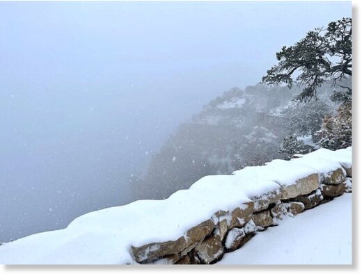
Grand Canyon’s South Rim Village around noon Oct. 12.
© E. Keable
Grand Canyon’s South Rim Village around noon Oct. 12.

Grand Canyon National Park has experienced the first snowstorm of the season Oct. 12.

The park reported that around 3:30 p.m., the fog and clouds parted to reveal the canyon.

Freezing temperatures tonight and Wednesday morning, with a gradual warming trend this weekend are expected in the Grand Canyon area.

South Rim Village roads have been plowed and are mostly clear, however wet road surfaces will turn into black ice in a few hours. The public is asked to watch their speed.

Foot traction and trekking poles are recommended on footpaths and trails.

View: https://youtu.be/V32MmljSVls
Run time is 2:49

A cabin on the North Rim at 9 a.m. Oct. 12.
© J. Pennington
A cabin on the North Rim at 9 a.m. Oct. 12.

The Canyon Rim Trail at Grand Canyon National Park, around 3 p.m. Oct. 12, just east of the historic South Rim Villag
© J. Baird
The Canyon Rim Trail at Grand Canyon National Park, around 3 p.m. Oct. 12, just east of the historic South Rim Villag
 

TxGal

Day by day
Snow makes an early fall appearance in northern Arizona -- Earth Changes -- Sott.net

Snow makes an early fall appearance in northern Arizona

Fox10phoenix.com
Tue, 12 Oct 2021 11:13 UTC

A cat investigated fresh snowfall in Flagstaff, Arizona, on October 12.

The calendar says it's fall, but many parts of Arizona got a dusting of white snow overnight, including Flagstaff, where many broke out the winter coats. FOX 10 Photojournalist Joe Tillman headed north for a look at the early winter blast.

The calendar says it's fall, but many parts of Arizona got a dusting of white snow overnight, including Flagstaff, where many broke out the winter coats. FOX 10 Photojournalist Joe Tillman headed north for a look at the early winter blast.

View: https://youtu.be/b8n66q7eI5E
Run time is 1:44

View: https://youtu.be/prcB4_PA7uo
Run time is 2:41
 

TxGal

Day by day
Winter weather arrives early, foot or more of snow in high country of Colorado -- Earth Changes -- Sott.net

Winter weather arrives early, foot or more of snow in high country of Colorado

Nicholas A. Johnson
Durango Herald
Tue, 12 Oct 2021 11:37 UTC

Clouds lift from the West Needles on Tuesday morning to reveal the snow-covered San Juan Mountains north of Durango.
© Jerry McBride/Durango Herald
Clouds lift from the West Needles on Tuesday morning to reveal the snow-covered San Juan Mountains north of Durango.

Mountain passes turn icy; Wolf Creek Pass closes for five hours

Winter may be a couple of months away, but Southwest Colorado got its first taste of cold and snow Tuesday, with reports of over a foot of snow in the high country.

Scott Stearns, a meteorologist with the National Weather Service in Grand Junction, said an official inch count of how much snow fell in the mountains north of Durango will not be available until Wednesday.

"We usually get a lot of reports the morning after the snow occurs," Stearns said.

Snow reportedly started falling just after midnight Tuesday, with the Colorado Department of Transportation reporting 6 inches of snow on mountain passes as early as 5:30 a.m.

"Our plow drivers were out plowing the surface of the roadways, and they've been after it throughout the day," said CDOT spokeswoman Lisa Schwantes.

View: https://youtu.be/83O2w91s-BE
Run time is 2:53

View: https://youtu.be/PHQyppdZIuk
Run time is 1:32

View: https://youtu.be/3zZotwM0j5U
Run time is 1:35

Schwantes said Red Mountain and Molas passes were the first to receive attention from plow drivers.

Silverton Mountain Ski Area co-owner Jen Brill said the town of Silverton received about a foot.

"We got about a foot in town, and we usually get double up there," Brill said.

Brill said Silverton Mountain's opening day is planned for Dec. 30, with heli-skiing starting around Thanksgiving.

"If it keeps up like this we're always willing to open up early," Brill said. "Usually for us opening is not about snow, it's about business. A lot of people don't want their first day of the season to be advanced and expert skiing."

Purgatory Resort did not have an official snow report as of late Tuesday afternoon, but said about 6 inches had accumulated around picnic tables.

"It was an absolutely gorgeous day," said Purgatory spokeswoman Amanda Anderson.

Anderson said Purgatory had to set up in the snow for this weekend's USA Cycling Collegiate Mountain Bike National Championship.

"It was fun to see the juxtaposition of the cycling event setup in the snow," Anderson said.

A winter storm took a toll on fall colors early
© Jerry McBride/Durango Herald
A winter storm took a toll on fall colors early Tuesday in Southwest Colorado.

Anderson said with Wednesday's forecast reported to be warmer and sunny, the cycling event is still in the plans.

"We can only control what we can control, and we're going to do the best we can to pull it off," Anderson said.

Snow flurries were reported at Mancos and Ridgway state parks, but according to Colorado Parks and Wildlife spokesman John Livingston, the snow was not sticking.

Alongside the snow were high winds, which took a toll on some of the colorful fall leaves. The time for optimal leaf peeping seems to be past.

"The cold weather will have a lot more leaves falling this week, and we are definitely past our peak in the high country," Livingston said.

Wolf Creek Pass was closed for about five hours as a safety precaution on Tuesday, Schwantes said.

"We had several vehicles spinning out, in particular large commercial vehicles, as well as a jackknifed semitruck," Schwantes said. "It was considered a safety closure."

Schwantes said as winter weather approaches, drivers should "know before you go."

"We just want to remind everyone that they need to think about their journey before driving out of their driveway," Schwantes said. "Check the weather forecast, be sure to check on road conditions at cotrip.org, take a look at our cameras and see if you're comfortable driving those conditions."

While things are supposed to warm up on Wednesday, there may be more weather coming through Thursday.
 

TxGal

Day by day
They're Measuring Snow In The FEET Across The Rocky Mountains, Coldest Early-October Day In [At Least] 125 Years Strikes Seattle, as Historic Cold Keeps China Coal Prices High - Electroverse

early-snow.jpg

Articles Extreme Weather GSM

THEY’RE MEASURING SNOW IN THE FEET ACROSS THE ROCKY MOUNTAINS, COLDEST EARLY-OCTOBER DAY IN [AT LEAST] 125 YEARS STRIKES SEATTLE, AS HISTORIC COLD KEEPS CHINA COAL PRICES HIGH
OCTOBER 14, 2021 CAP ALLON

THEY’RE MEASURING SNOW IN THE FEET ACROSS THE ROCKY MOUNTAINS

The Rocky Mountains have received their first big snowfalls of the season, weeks ahead of schedule.

Since Monday, October 11 parts of Montana, Idaho, Wyoming and Utah have received well over 2 feet of early-season snow, with higher elevations receiving much, much more.

View: https://twitter.com/accuweather/status/1448384068727488515
Run time is 0:16

Likewise in Colorado, a widespread blast of cold and snow hit this week, with reports of over a foot of powder in the high country.

View: https://twitter.com/AdiGTV/status/1448152893505224704
Run time is 0:13

Jen Brill, co-owner of Silverton Mountain Ski Area, said the town of Silverton received about a foot, while the hills received about double that. Silverton’s opening day is currently planned for Dec 30; however, “If it keeps up like this we’re always willing to open up early,” said Brill.

One Colorado ski area is opening this weekend after 14 inches hit its slopes. In a recent Facebook post, Wolf Creek confirmed that its beginner ‘Nova Lift’ would be open on October 16 and 17, weeks earlier than normal.

View: https://twitter.com/jnetnon/status/1448558288157691907

Headed east, South Dakota also experienced its first major snowfall of the season.

A whopping 27 inches fell in parts of the Black Hills, according to the National Weather Service. Residents of Rapid City reported just over three inches. While just outside Rapid City, areas received up to nine inches of snow.

North of the Black Hills, Spearfish saw accumulations of 15 inches throughout the city near the Wyoming border:

View: https://twitter.com/CaptainGhazi/status/1448355531937271812
Run time is 2:20

View: https://twitter.com/RapidCityRegEng/status/1448301489211035651
Run time is 0:06

Looking ahead, a second system –that arrived Wednesday– is expected to last through the weekend.

According to fox6now.com, the front will “easily” drop over a foot of snow in some areas of Wyoming and Colorado.
“Winter Storm Watches and Warnings are currently in effect where snowfall totals of 1 to 2 feet are possible,” said the Weather Prediction Center — these alerts stretch from Utah to Montana.


GFS 2m Temperature Anomalies (C) Oct 14 [tropicaltidbits.com].


GFS Total Snowfall (inches) Oct 14 – Oct 30 [tropicaltidbits.com].

COLDEST EARLY-OCTOBER DAY IN [AT LEAST] 125 YEARS STRIKES SEATTLE

This week, the Seattle region is experiencing some of its coldest early-fall days in over 125 years.

According to the National Weather Service, Tuesday’s average temperature of 43F marked the coldest day Seattle has ever seen during the first two weeks of October — the previous record was the 43.5F set on Oct 14, 1899 (the Centennial Minimum).

And when the city dipped to 36F early Tuesday morning, that was also the coldest October low in nearly two decades.

Furthermore, Pullman suffered its coldest Oct 13 on record yesterday: a low of 43F beat out the 44F from 1969.

Seattle’s early-season chill marks the latest in a series of extreme weather events in the Puget Sound region in 2021, reports mynorthwest.com: Back on Feb 13, 8.9 inches of snow fell across the region — the snowiest day Seattle had seen in any month in 52 years, and the most it had seen on a February day in almost a century. Additionally, between Feb 12 and Feb 13, the city also saw the most snow over a two-day period in 49 years. In early June, widespread thunderstorms drenched the Puget Sound region, breaking a number of rainfall records. Then three weeks later, a heat wave broke records across Western Washington, with high temperatures everywhere from Bellingham down to Olympia.

And now, the region (as well as the entire western half of the U.S.) is suffering a stark return to the cold — this reality, far from supporting the baseless AGW theory, actually serves as evidence of the swings between extremes we see during bouts historically low solar activity–due to the loss of energy in the jet streams:


The sun is currently experiencing its lowest output in more than a century (an irrefutable fact btw), and projecting forward, a number of climate scientists and astrophysicists have long-suggested that the next cycle (26) will be weaker still, perhaps even non-existence, akin to those during the Maunder Minimum (1645-1715), which in turn will usher in the next Grand Solar Minimum:


HISTORIC COLD KEEPS CHINA COAL PRICES HIGH

As reported by Reuters, China coal prices held near record highs on Thursday as cold weather swept into the country’s north and power plants stocked up on the fuel to ease an energy crunch that is fueling unprecedented factory gate inflation.

An increasingly concerning power crisis in China –caused primarily by shortages of coal and gas due to a record cold winter of 2020-21 which depleted supplies– has halted production at numerous factories, including many supplying big global brands such as Apple.

The producer price index (PPI) has soared to its highest in at least 25 years, rising 10.7% year-on-year, official Chinese data on Thursday showed.

Cold weather is expected to worsen the situation — and on Wednesday, China’s National Meteorological Center warned that strong northerly winds will drive the average temperature down by as much as 14C across large parts of the country this week.

Already, the three northeastern provinces of Jilin, Heliongjiang and Liaoning along with several regions in northern China including Inner Mongolia and Gansu, have begun winter heating early to cope with the colder-than-normal weather, continues the Reuters article.

In fact, winter is ramping-up early across much of Asia.

Below are the East Asia’s forecast temperature anomalies for today, Oct 14:


GFS 2m Temp Anomalies (C) Oct 14 [tropicaltidbits.com].

And depicted below are those “strong northerly winds” the China Meteorological Department sees approaching — Arctic air is forecast to funnel into the majority of the region and drive temperatures down as much as 16C below seasonal norms:


GFS 2m Temp Anomalies (C) Oct 16 [tropicaltidbits.com].

Stating the obvious, this is bad news for the region — and while Beijing has taken a slew of measures to contain the rise in energy prices, including raising domestic coal output, and the rationing of power at factories, the situation remains dire.

Of late, Beijing had reportedly been trying to reduce its reliance on polluting coal power in favor of cleaner wind, solar and hydro — but this has proven an abject failure, and has only compounded the energy crisis.

“Making sure people are warm and keep businesses running — that’s obvious, of course you need to that,” said Dimitri de Boer, chief China representative with the European environmental consultancy ClientEarth. “Even as an environmentalist you don’t want to get into a situation where you risk turning society against the climate transition. But that should be coupled with deploying renewables as fast as possible, to avoid similar situations in the future.”–Again, we see a brainwashed climate stooge compounding a real-world crisis with ideologically-hamstrung claptrap.

As of Sept 27, more than half of Mainland China had already enforced power consumption cuts:

Reuters Graphics
[Reuters]

Moreover, this power crisis isn’t just confined to China — it is global.

From India to Europe, politicians are struggling to understand how the situation could have gotten this bad. But we realists understand all too well: politics bedded those ‘green ideals’ a little too eagerly, followed the AGW Party line a little too closely, and as a result they’ve been burned–not by the anthropogenic global warming boogeyman, but instead by the unfolding of a genuine climatic crisis: global cooling.

These puppets of the elite now find themselves totally unprepared for winter. I’m sure their ‘expert’ climate modelers foretold of milder and milder winters which in turn would translate to a lower heating demand, but now, and as a direct result of this fraudulent faux pas, many ordinary people will be unable to heat their homes this winter, and some, tragically, are going to freeze to death (as we saw in Texas earlier in the year).

Like a nightmare you can’t easily escape, the indoctrinated masses need to forcibly shake themselves off the totalitarian track they’re marching us all down. Their global warming/climate change is propped-up by propaganda, not science — global average temperatures, as measured by the satellites, prove this every day/week/month of the year. And moreover, ALL alarmist predictions of the past 30/40 years have FAILED — literally every single one.

“We’ve got a cold winter dead ahead, and it’s going to be financially painful for people,” said Mark Zandi, Chief Economist with Moody’s Analytics.

And finally, those 25,000+ politicians, climate ‘experts’ and journalists descending on Glasgow for the COP26 have been warned to pack appropriately as the city is expecting a bout of unusually “cold, wet and windy” weather during the event.

The frank admission is contained in official guidance issued to those planning a trip to the global climate summit starting from October 31. The guide reads: “We recommend ensuring delegates bring warm, waterproof clothing to ensure they stay warm and dry when outside.”

This level of stupidity reminds me of last year, when Scotland blamed its failure to meet its carbon emissions targets on “cold weather”:


Further reading:


The COLD TIMES are returning, the mid-latitudes are REFREEZING, in line with the great conjunction, historically low solar activity, cloud-nucleating Cosmic Rays, and a meridional jet stream flow (among other forcings).

Both NOAA and NASA appear to agree, if you read between the lines, with NOAA saying we’re entering a ‘full-blown’ Grand Solar Minimum in the late-2020s, and NASA seeing this upcoming solar cycle (25) as “the weakest of the past 200 years”, with the agency correlating previous solar shutdowns to prolonged periods of global cooling here.

Furthermore, we can’t ignore the slew of new scientific papers stating the immense impact The Beaufort Gyre could have on the Gulf Stream, and therefore the climate overall.


Prepare accordinglylearn the facts, relocate if need be, and grow your own.
 

TxGal

Day by day
Dang. One of guys we all watch on here (can't remember if it was Ice Age Farmer or the Adapt 2030 guy, David DuByne) has said numerous times "WATCH OATS - They are the canary in the coal mine."

Yep, for both people food and livestock food, too.

I received my case of quick oats from the LDS today, and I wish I'd bought two cases. Not looking good out there in the grocery stores today. I went to three different stores today while running around for hours on med appts, and the produce section at HEB in Huntsville was really hit hard. There was only half a bin of loose red potatoes when usually there are two full ones, and no bags of red potatoes left. I saw cuts of meat I've never seen before, or heard of - beef 'feet' (hooves)...really??!!

Martinhouse - warning on the potatoes, they're in short stock. I've got to plant potatoes...
 

Martinhouse

Deceased
TxGal, I'm hoping to shop in the morning and am planning to get at least one more 5# bag of reds. Buy my sis grabbed the last two of them this afternoon at our little store. I do already have some, but they don't all last until spring so I'd prefer to get more if possible.

I would have shopped this morning, but I wasn't able to even fall asleeo until 5 AM and at my age I won't drive in the dark with little or no sleep.

I'm somewhat worried what I might find by the time I finally get to that store and then the Dollar General, too.

Oh, our Dollar General will be closed Nov. 14 through 17 to change the store all around and they are expanding the grocery section. I'm glad because the little grocery is so high-priced, but wonder about their timing!

Well, back to bed. I just came out to get a snack.
 
Top