WEATHER Severe Weather the Week of May 6th, 2024

Donna_in_OK

Veteran Member
Storms are tightening up in OK.

Just checked ADSB for giggles, and our current hot section is empty except for a few news copters giving us the bird's eye view.

KOCO.com
News9.com
kfor.com

I know the first 2 channels have youtube channels and will probably be live with all of our weather trackers. Plus the eye in the sky view. ;)
 

packyderms_wife

Neither here nor there.
Whatcha cookin'?

Should I head thataway?

Doesn't look like things are really going to get sporty for another coupla hours.

Steak fajitas, homemade guac and pico to go with, maybe some refried black beans. He has a trainee today, that's a total noob, so won't be home from work until close to 8pm.

That's what Ryan said, as well as the local weather guessers here in central Iowa.
 

packyderms_wife

Neither here nor there.
Oklahoma

Tornado Warning
OKC011-043-070000-
/O.NEW.KOUN.TO.W.0097.240506T2320Z-240507T0000Z/

BULLETIN - EAS ACTIVATION REQUESTED
Tornado Warning
National Weather Service Norman OK
620 PM CDT Mon May 6 2024

The National Weather Service in Norman has issued a

* Tornado Warning for...
Northwestern Blaine County in northwestern Oklahoma...
Southeastern Dewey County in northwestern Oklahoma...

* Until 700 PM CDT.

* At 619 PM CDT, a severe thunderstorm capable of producing a tornado
was located near Putnam, moving east at 40 mph.

HAZARD...Tornado and golf ball size hail.

SOURCE...Radar indicated rotation.

IMPACT...Flying debris will be dangerous to those caught without
shelter. Mobile homes will be damaged or destroyed.
Damage to roofs, windows, and vehicles will occur. Tree
damage is likely.

* Locations impacted include...
Canton, Oakwood, Putnam, and Eagle City.

PRECAUTIONARY/PREPAREDNESS ACTIONS...

TAKE COVER NOW! Move to a storm shelter, safe room or an interior
room on the lowest floor of a sturdy building. Avoid windows. If you
are outdoors, in a mobile home, or in a vehicle, move to the closest
substantial shelter and protect yourself from flying debris.

&&

LAT...LON 3608 9851 3583 9848 3581 9896 3581 9900
3595 9905
TIME...MOT...LOC 2319Z 254DEG 35KT 3588 9893

TORNADO...RADAR INDICATED
MAX HAIL SIZE...1.75 IN

$$

30
 

Red Baron

Paleo-Conservative
_______________
Warnings over the last half hour,
-----------------
College of DuPage Meteorology
Severe Weather and Flash Flood Warnings

Note: This page will reload every 2 minutes. Warnings are listed with the most recent first.
Click on the station ID to bring up list of recent severe weather statements.

SVR T-STORM WARNING WICHITA KS - KICT 628 PM CDT MON MAY 6 2024
SVR T-STORM WARNING NORMAN OK - KOUN 628 PM CDT MON MAY 6 2024
SVR T-STORM WARNING TOPEKA KS - KTOP 627 PM CDT MON MAY 6 2024
SVR T-STORM WARNING NORMAN OK - KOUN 626 PM CDT MON MAY 6 2024
SVR T-STORM WARNING NORMAN OK - KOUN 625 PM CDT MON MAY 6 2024
TORNADO WARNING NORMAN OK - KOUN 624 PM CDT MON MAY 6 2024
TORNADO WARNING NORMAN OK - KOUN 620 PM CDT MON MAY 6 2024
SVR T-STORM WARNING MORRISTOWN TN - KMRX 716 PM EDT MON MAY 6 2024
FLASH FLOOD WARNING CHARLESTON WV - KRLX 707 PM EDT MON MAY 6 2024
SVR T-STORM WARNING WICHITA KS - KICT 602 PM CDT MON MAY 6 2024
SVR T-STORM WARNING GREENVILLE-SPARTANBURG SC - KGSP 700 PM EDT MON MAY 6 2024


somdwatcher

Veteran Member
We are now heading into the nighttime where the potential for strong/violent tornadoes is suppose to increase across Oklahoma.
 

SurvivalRing

Rich Fleetwood - Founder - author/coder/podcaster
May 3rd 1999 was a big outbreak in same area. Highest F-5 tornado winds ever recorded hit between Bridgecreek and Moore Oklahoma. Spent 5 weeks there with FEMA as a DSO. Incredible destruction, sod pulled off ground, asphalt roads lifted and torn away, bottom plates of walls ripped off slabs, full water tower ripped from its piers and toppled. Ironically, we're just over the 25 year aniversary of that Moore tornado with a similar situation developing today. Be safe and hit the storm shelter or get out of harms way if F-4/F-5 twisters spin up.
View: https://youtu.be/GMqwwkO7u8o?si=dXuNIBtscf3g9xar

rt - 20:34

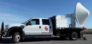
I very vividly remember that very specific storm. It was originally reported at winds of 318 mph, the upper limit of an F-5. This was detected by a mobile Doppler truck mounted radar system.

IMG_3615.png

From the page below ::

The 1999 Bridge Creek–Moore tornado (locally referred to as the May 3 tornado) was a large and exceptionally powerful F5 tornado in which the highest wind speeds ever measured globally were recorded at 301 ± 20 miles per hour (484 ± 32 km/h) by a Doppler on Wheels (DOW) radar. Considered the strongest tornado ever recorded to have affected the metropolitan area, the tornado while near peak intensity devastated southern portions of Oklahoma City, Oklahoma, United States, along with surrounding suburbs and towns to the south and southwest of the city during the early evening of Monday, May 3, 1999. Parts of Bridge Creek were rendered unrecognizable. The tornado covered 38 miles (61 km) during its 85-minute existence, destroying thousands of homes, killing 36 people (plus an additional five indirectly), and leaving US$1 billion (1999 USD) in damage,[5] ranking it as the fifth-costliest on record not accounting for inflation.[6] Its severity prompted the first-ever use of the tornado emergency statement by the National Weather Service.


I'd like to note that the original Building Practices Assessment Team (BPAT) report pdf file that FEMA had on their website listed my original AOL website as one of five sites for more info.


IMG_3613.jpeg

We had our own close call with the April 8th, 1998 F-5 twister that missed our home in central Alabama, by only a couple of miles, but directly hit the home of Annie’s aunt’s house.

These dam storms are the BIGGEST reason we have lived in Wyoming since 2000.
 

Millwright

Knuckle Dragger
_______________
13 minutes ago24 minutes from nowtornadoAt 822 PM CDT, a severe thunderstorm capable of producing a tornado was located near Sherman, or 17 miles southwest of Pipestone, moving northeast at 55 mph.
show me the full warning
Pipestone / Minnehaha / MoodyMN / SDshow me
14 minutes ago9 minutes from nowtornadoAt 822 PM CDT, a severe thunderstorm capable of producing a tornado was located 7 miles south of Johnson, or 8 miles southwest of Auburn, moving northeast at 45 mph.
show me the full warning
Nemaha / OtoeNEshow me
16 minutes ago9 minutes from nowtornadoAt 820 PM CDT, a severe thunderstorm capable of producing a tornado was located 7 miles north of Colman, or 14 miles south of Brookings, moving north at 55 mph.
show me the full warning
Brookings / Lake / MoodySDshow me
26 minutes ago9 minutes from nowtornadoAt 810 PM CDT, a severe thunderstorm capable of producing a tornado was located over Rowena, or 10 miles east of Sioux Falls, moving northeast at 55 mph.
show me the full warning
Lyon / Rock / MinnehahaIA / MN / SDshow me
27 minutes ago9 minutes from nowtornadoAt 808 PM CDT, a severe thunderstorm capable of producing a tornado was located near Moonlight, moving northeast at 45 mph.
show me the full warning
Clay / Dickinson / Geary / RileyKSshow me


From TornadoHQ


anna43

Veteran Member
Here we go again. Took supplies to shelter and waiting to see what happens. It's starting with wind and rain right now. If the town sirens go off, I'll head downstairs. If I didn't have a basement shelter area, these watches and warnings would cause a nervous breakdown. I've survived one F4 or F5 (although the house didn't!) and really do not want to do it again!! Tornados are over quickly but the recovery is a long-term nightmare dealing with everything.
 

Meemur

Voice on the Prairie / FJB!
Yeah, the cat and I are going to sleep in the basement tonight. I hate getting up after I've gone to bed when the tornado sirens go off.

I'm so glad that the ash tree was removed last Friday! I don't have to worry about waking up to a horrible, expensive mess in the front yard.
 

moldy

Veteran Member
DD#2 said they closed the bar/restaurant she works at in Wichita due to the storm. Very strange - it's spring in KS. There will be storms/tornadoes. Is this year supposed to be uber-bad or something?

She wanted me to call my mom ("Call Granny and let her know we're under a warning.") Granny grew up in Enid - pretty sure she knows, but I'll call anyway. Mom was watching the weather - out on her front porch like any good Kansan does.

You all stay safe. I hate the tornados that come in at night.
 

anna43

Veteran Member
Current warning here is severe thunderstorm. Wind is picking up but it's not raining yet. Tornado warning just south of us so I'm keeping alert. I'll be staying dressed and shoes on until it all blows over. Oops just went to tornado warning. Heading downstairs.
 

PrairieMoon

Veteran Member
Big tornado hit a town in Oklahoma called Barnsdall (pop ~1000) with 2 confirmed fatalities and people trapped.

The tornado also may have hit Bartlesville, where my daughter and grands live. They took shelter and are ok. Extended family ok also.

Stay safe, Anna!!
 

Millwright

Knuckle Dragger
_______________
Big tornado hit a town in Oklahoma called Barnsdall (pop ~1000) with 2 confirmed fatalities and people trapped.

The tornado also may have hit Bartlesville, where my daughter and grands live. They took shelter and are ok. Extended family ok also.

Stay safe, Anna!!

Ohhh chit.

This system was looking like an overblown fizzle.

It might be picking up some momentum now.

Didn't think we'd even get rain, south of I-40.

Now, this tornado up north and some cells popping up out west, south of 40.

I guess it ain't over.
 

Pinecone

Has No Life - Lives on TB
Big tornado hit a town in Oklahoma called Barnsdall (pop ~1000) with 2 confirmed fatalities and people trapped.

The tornado also may have hit Bartlesville, where my daughter and grands live. They took shelter and are ok. Extended family ok also.

Stay safe, Anna!!
I am watching Ryan Hall, Ya'll and a trailer park or two was hit.
 

jward

passin' thru
fatalities confirmed via scanner traffic


Oklahoma Tornadoes ️
@OKTornadoDB

Barnsdall #okwx #tornado update @ 10:30 pm.

- Debris lofted over 30,000 feet
- perhaps reached over a mile wide.
- At least 2 fatalities
- multiple entrapments
- homes leveled
- Command Post set up at Barsndall PD with resources being brought in
- Gas leaks present
- SaR is ongoing
- OHP, Sheriff, EM, Fire, and EMS on scene
- Triage at a local gas station
- East side seems to have taken the worst damage
- Walking wounded and survivors going to HS area where a spot is set up
 
Top